->

27 September 2007

Hotmap - Virtual Earth Users Map

Hotmap - A good way to show your Virtual Earth (Live Maps) user base.

Hotmap Virtual Earth Users
This data is based on a sample of tile logs on servers from January through July of 2006.
It combines server hits from road, aerial, and hybrid imagery in one view.
  • Zoom in and out with the control widget in the top left. You can also zoom in by double-clicking the mouse; and zoom in or out with the mouse wheel.
  • Pan by clicking and dragging on the map surface.
  • Inspect a specific point by right-clicking. It shows the exact imagery available at the point clicked, at the current data level.
  • Works in FireFox too!
"Hotmap shows where people have looked at when using Virtual Earth, the engine that powers Live Search Maps: the darker a point, the more times it has been downloaded. Each square represents one unit of imagery, called a "tile". When the program starts, it shows tiles at zoom level 11, which has tiles at a resolution of 74 meters-per-pixel. At the closest in, Virtual Earth has tiles at zoom level 19, 0.3 meters-per-pixel. You can look at higher- or lower-resolution points with the "select data level" indicator at the top."

http://hotmap.msresearch.us/


Now it would be good to see results from Yahoo Maps, Multimap, Google Maps and others...


Labels: , , , , ,

25 September 2007

MultiMap Open API + Ordnance Survey Data

MultiMap Open API + Ordnance Survey Data

Ordnance Survey 1:50,000 Data is now accessible to API developers

is it true?

You can Zoom in and Pan.

A bigger version is available here
http://mapperz.googlepages.com/Multimap_Sample_OS50k_bigger.html

"At Multimap we’re [they are] very proud of the wide range of local and global mapping data available on our website and through our API, and are committed to providing as much of this data via the Open API as we [they] can. To that end, we’re very pleased to announce the availability of Ordnance Survey Landranger maps (at 1:50000 scale across zoom levels 13, 14 and 15) through the Open API.

The Landranger data covers England, Scotland and Wales and provides a wealth of topographic features, such as contour lines, tourist attractions and historic features such as Roman roads. These maps are great for walkers, cyclists, or for providing detailed maps of rural areas. We can’t wait to see how people make use of them through the Open API."


http://blog.multimap.com/


A good but probably expensive (regards to licensing) move by Multimap.

Mapperz

Labels: , , , ,

24 September 2007

Route Scanner - Incidents and Delay Map

Route Scanner - Incidents and Delay Map

This is a fantastic UK Route Planner that works out delays, incidents and tells you the speed/traffic light camera locations along your own route.

Route Scanner created Paul Clark
Paul Clark has developed a clean and informative results page - Colour coded to severity (shades of red).
Uses the Google Maps API Driving Directions and Live Feeds from BBC Travel and the Highways Agency

Quick Guide
  1. Enter your start and destination.
  2. Choose a Buffer distance (1,2 and 5 miles)
  3. Choose Speed Cameras (Don't Show,Show Speed Cameras, Show All)
  4. Press 'Serach'

"Route Scanner uses live traffic information (e.g. accidents, roadworks and delays) combined with a route planner to calculate which incidents could affect that particular journey. It combines the power of Google Maps with the real-time information provided by BBC Travel and the Highways Agency. Route Scanner doesn't just look for traffic and travel updates on motorways and other major roads but through the road network."

Paul Clark also has developed other websites...
Well Done for creating an Excellent UK Mashup
Mapperz

Labels: , , , , , , ,

20 September 2007

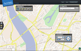
ArcWeb Explorer (Beta) 2.0

ArcWeb Explorer (Beta) 2.0
ArcWeb Explorer 2.0 application, which offers powerful Web map rendering with desktop-like functionality.

ArcWeb Explorer 2 (beta) - Rotated Map
source: ESRI

The rotating map is a clever bit of code - the text flips (renders) itself when it goes beyond 180 degrees.

ArcWeb Explorer 2.0 Application

ArcWeb Explorer 2.0 Flex API

ArcWeb Explorer 2.0 JavaScript API

Exposes ArcWeb Services functionality through easy-to-use widgets

Enables developers to build and/or customize applications

Offers the use of a powerful subset of ArcWeb Services functionality

Offers the ability to quickly find locations, pan and zoom, and choose a map type Provides access to all ArcWeb Services Provides access to ArcWeb Services content
Provides access to street, street tile, aerial imagery, hybrid (integrated street and aerial), shaded relief, and topographic maps Allows for easy and powerful ArcWeb integration inside Adobe Flex Builder Enables easy integration of mapping functionality and content into HTML Web applications
NOTE: The Flex API is designed specifically for use within Adobe Flex 2. The JavaScript and Flex APIs are not designed for use within Adobe Flash Professional.
source: ESRI

To use this service you will be required to login in.
ArcWeb 2.0 Home Page

ArcWeb Explorer JavaScript Example
JavaScript Sample

ArcWeb Explorer Flex Example
Flex Example

Both have the code generated on the fly - therefore it is faster to get up and running with your own apps and data.

Is this to challenge the likes of Google Maps, Virtual Earth and Yahoo Maps API's?
We will see...

Mapperz

Labels: , , , , , , ,

19 September 2007

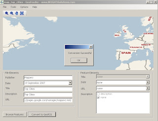
Brighti Solutions - GeoData to GeoRSS

Brighti Solutions - GeoData to GeoRSS

Get your data unlocked and web ready. It's quick and clever
Brighti Solutions GeoRSS Output
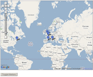
At first glance locations seems displaced. But in the Google map (below) locations are in the correct location.

"Yet the problem remains that most geodata is locked away in formats that don't play nice with the major web mapping providers"

"That’s where BRIGHTi GeoFeeder comes to the rescue"

  • Convert to all variations of GeoRSS formats including RSS, ATOM and Simple,GML,
  • Works with the following formats/extensions: .kml, .kmz, .gml, .shp, .mif, .dxf
  • Convert vector data (points, lines and polygons) to GeoRSS
  • Map feature attributes to GeoRSS attributes
  • Specify multiple attributes for elements
  • Displays all features on a Virtual Earth map
  • Browse features and attributes
  • Zoom and pan
Brighti Solutions GeoRSS Google Map
This map took 30 seconds to create - code from the official example
http://www.google.com/apis/maps/documentation/
examples/geoxml-rss.html
*change api key to your website
*change url of the georss.xml (GeoRSS file)
done!
Nice work.

Suggestions
More formats please
hyperlinking urls (like to products - this can be done if edit the xml file)
feedback forum to share issues and solutions

Labels: , , , , , , , ,

18 September 2007

Mapserver 5.0.0 Released

Mapserver 5.0.0 Released

"Beyond browsing GIS data, MapServer allows you create "geographic image maps", that is, maps that can direct users to content"

MapServer Example (in final testing)
Example Screenshot of Mapserver

New features in Mapserver Version 5.0.0:
------------

- MS RFC 19: Added Style and Label attribute binding

- MS RFC 21: Raster Colour Correction via colour lookup table

- MS RFC 27: Added label priority

- MS RFC 29: Added dynamic charting (pie and bar charts)

- MS RFC 31: New mechanism to load/set objects via URL using mapfile syntax

- MS RFC 32: Added support for map rendering using the AGG library for
better output quality


Long time issues resolved:
-------------------------

- MS RFC 17: Use dynamic allocation for symbols, layers, classes and styles
(got rid of the static limit on the number of instances of each in a map)

- MS RFC 24: Improved memory management and garbage collection for MapScript

- MS RFC 26: Terminology cleanup (layer transparency renamed to opacity,
scale becomes scaledenom, symbol style becomes symbol pattern)

- MS RFC 28: Enhanced the debug/logging mechanism to facilitate
troubleshooting and tuning applications. Added support for multiple
debug levels and more control on output location.

Change log
http://trac.osgeo.org/mapserver/browser/tags/rel-5-0-0/
mapserver/HISTORY.TXT

source: Slashgeo

Labels: , ,

Google Maps coverage expands - 54 more countries

Google Maps coverage expands... 54 more countries covered.

Update 18/09/2007
Pamela Fox (Google Maps API Team) introduces Google Spreadsheets New Features that use your data (xml, html, csv, tsv, as well as RSS and Atom based)


In combination with the Google Maps API you can now view the new tiles via her mashup.


note1 - the Google Geocoder is not perfect.
(click on Costa Rica and you will see)

*Note- Additionally, the limit on functions per spreadsheet is 50.

previous post
Click a hyperlink to view the new coverages - some are limited in content.


Afghanistan
Aruba
Bahamas
Bahrain
Bangladesh
Belize
Bermuda
Brunei Darussalam (limited coverage)
Bhutan (limited coverage)
Bolivia (limited coverage - cities only)
Cambodia
Chile
Colombia (limited coverage - 50% approx)
Costa Rica
Cuba
Ecuador
El Salvador
Fiji (very limited coverage)
Guatemala
Haiti
Honduras
Indonesia (limited coverage)
Iraq
Iran
Jordan
Kazakhstan (limited coverage)
Kyrgyzstan
Kuwait
Laos
Lebanon
Mexico
Myanmar (Burma)
Mongolia
Nepal
Nicaragua (limited coverage - 50% approx)
Oman
Pakistan
Panama (fragmented coverage)
Paraguay (very limited coverage)
Peru(very limited coverage)
Philippines
Papua New Guinea
Qatar
Saudi Arabia
Sri Lanka
Syria
Tajikistan
Turkmenistan
Timor-Leste
Uruguay
Uzbekistan
Venezuela (limited coverage - 50% approx)
Vietnam
Yemen (limited coverage)

*Coverage only approximated by Mapperz

Source:
http://google-latlong.blogspot.com/2007/09/
more-of-world-for-you-to-explore.html

Labels: , , , ,

14 September 2007

Yahoo! MapMixer + Quick User Guide

Yahoo! MapMixer + Quick User Guide

What is MapMixer? "The world is a big place. There are thousands of maps out there that provide unique details about any given destination. MapMixer is a new site that combines those maps with Yahoo! Maps to give you a better view of the world. It's easy to mix your own map. Upload an image of your map, use our layering tool to align it with Yahoo! Maps and we'll do the rest! Your map will have all the features of Yahoo! Maps (zooming, panning). You can also syndicate it on your own site or blog."

Quick user guide
Sign in to Yahoo.
Upload your jpeg,gif or bmp.
(no tif support at present.)

Yahoo Map Mixer Georeference Point
Two Points are needed to estimate the geographical position of the image.
Traditionally in a GIS environment this is at least 3 points.

*Top Tip - use the opacity setting

Yahoo MapMixer Georeferenced Opacity Setting
Use the control points on the edges of the image. Yahoo Mapmixer allows you to unpin your image which enables the moving of the yahoo map base


Yahoo MapMixer Georeferenced Rotate Image
Use the green circle to rotate the image - this helps to get an exact fit of the image.
*rotated image exaggerated here for example of the function.

Reproduced from Ordnance Survey map data by permission of the Ordnance Survey © Crown copyright 2001.

Map Source
http://www.ordnancesurvey.co.uk/oswebsite/freefun/outlinemaps/

"You must not use the images for financial gain. All hard copies and electronically published material produced from Ordnance Survey data must carry the acknowledgment:
Reproduced from Ordnance Survey map data by permission of the Ordnance Survey © Crown copyright 2001."

not sure about the hula hooping mice - a progress bar maybe?

Please observe copyright Christian Spanring explains it clearly

Labels: , , , , ,

Google Moon Update (Map & Charts)

Google Moon Update (minus the cheese)

Google Moon Updated


  • Higher Resolution Images
  • Moon 'Walk' View
  • No Cheese (was on max zoom - Wallace & Gromit ate it all?)

Data/Map Types:

Visible - A mosaic of images taken by the Clementine mission. This is a black-and-white version of what you would see if you were in orbit around the moon. This composite imagery was prepared by the USGS.
Elevation - A lunar terrain map generated by the USGS in conjunction with the The Unified Lunar Control Network 2005, and shaded using an airbrushed shaded relief map. This map is colour-coded by altitude, so you can use the colour key at the lower left to estimate elevations.
Apollo - A collection of place marks that tell the story of the Apollo missions that landed on the moon. This includes stories, quotes, images, panoramas, audio clips, and links to videos of the astronauts' adventures on the lunar surface.
Charts - A collection of geological and topographic charts of various regions of the moon.

Official Post
http://google-latlong.blogspot.com/2007/09/new-moon.html

Labels: , , , , , ,

13 September 2007

MapNik - OpenStreetMap - Google Maps API (Custom Tile)

MapNik - using OpenStreetMap in Google Maps API (as a Custom Tile)

Mapnik Map Transition with Google Maps
MapNik with OpenStreetMap (Oxford,UK) using Google Map API (Custom Tile) works really well. (gif transition created by Mapperz)

"Mapnik is a Free Toolkit for developing mapping applications. Above all Mapnik is about making beautiful maps. It is easily extensible and suitable for both desktop and web development."


UPDATE Starting from 0.4 Mapnik runs on Linux, Mac OS X (10.4.9), Win32 and FreeBSD


Mapnik can read ESRI shapes, PostGIS databases and TIFF rasters
more?
"As always, there are lots of things in the pipeline"

Features

  • Projection transformations
  • Multiple named styles in WMS
  • Line following' text labels
  • 'Shield' symbolizer
  • Feature querying
  • Character encodings support
  • GetFeatureInfo with text/plain and text/xml output
  • Support for right to left languages
If you want to see the functionality of Google Maps and the more detailed (less in some respects)
go to the Demo Area of MapNik website for more examples.

There are other Maps available (a good working one it Victoria, British Columbia)
http://mapnik.org/maps/


*Mapperz used Adobe Image Ready to visualize the cartographic differences between MapNik and the Normal tiles available in Google Maps API

Labels: , , , , ,

12 September 2007

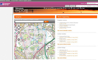
Ordnance Survey Explore (Beta)

Ordnance Survey Explore

OS Explore Beta

Ordnance Survey have launched 'OS Explore', a website designed for walkers, runners, hikers, cyclists, anyone with the interest with the great outdoors and sharing their routes and personal favourite places.

OS Explore Route

Though there is room for improvement:
  • No Help or FAQ - to get non map people to 'get started'
  • No Editing of your own routes (that's a bit silly)
  • No 1:25,000 (Explorer) Mapping is all 1:50,000 (Landranger) (OS have copyright on their own data surely?)
  • No Polygon creation (Area) - only Lines and POI Points.
  • No Export so cannot use the route in a GPS

Well it's a start from the Ordnance Survey - but clearly in Beta.

Needs to be more 'MyMaps' in functionality

Add your comments on the service - maybe they take note, maybe not.


*Routes are British National Grid not WGS84

Ed Parsons (ex Ordnance Survey) also mentions it in his blog

Official Reply on the editing of routes
"Unfortunately, at the current time, users are unable to edit routes once they have been saved. However, before saving, users are able to undo waypoints they have plotted and remove their points of interest. There are several usability changes envisaged for the next release and this is an area we would like to see improved. The site is still in its beta stage so obviously we are keen to hear about any issues encountered."

Labels: , , , , ,

11 September 2007

Embed Ask City Maps

Embed Ask City Maps

Ask City map now allows you to embed the maps into your blog/website similar to Google Maps.


Though 'Ask' has a clever function not seen before - searching within a polygon.

This map was to find Bourne Ultimatum films showing in cinemas in Greater London

How is this function achieved?
Draw a Polygon of the search area. (used the M25 as boundary)

Then when the polygon is completed (double click to close)
a little search magnifying glass appears.

Ask City Search by Shape

Clearly the Ask help is not updated with this

There is a some way to go, only a few results where returned. Looks like the bounding box was (map extent) was used rather than the actual polygon.
But a good step in the geographical spatial search method.

Real spatial searches in 'Search Engines' and web based maps? Maybe very soon.
A quick fast method would be to send the centre coordinates with a radius distance and use a spatial database (postgres is extremely powerful and fast at this) to return all the locations based on the search terms to give the user the first ten.
*postgres can do this in milliseconds.

Labels: , , , , ,

10 September 2007

National Intrusion Map England

National Intrusion Map for England

National Intrusion Map - England
Source: CPRE
The Campaign to Protect Rural England (CPRE) has releases New Maps depicting the Intrusion of many sources (traffic, rail, air, dense population, power lines etc) that lead us to a more intrusive way of life.
  • Within 3km
- of very high disturbance roads such as most major motorways and A roads (e.g. M25, M1, M6) with over 75000 daily traffic flow
- of the edge of large towns of over 270,000 people (e.g. size of Southampton, Liverpool)
- of power stations;
  • Within 2km
- of sections of some motorways (e.g. M6 north of Preston) and many urban A roads with 25,000 to 75,000 daily traffic flow (e.g. A184 in Durham or A24 in West Sussex);
- of the edge of smaller towns of 4,000 to 270,000 people;
  • Within 1km
- of many urban A roads (e.g. within London or Birmingham) and some rural A roads with 10,000 to 25,000 daily traffic flow or ;
- of the published noise contour (57 decibels equivalent sound figure) for civil airports;1
Within 0.5km
- of many rural A roads with 5,000 to 10,000 daily traffic flow (e.g. A594 between Ambleside and Keswick in the Lake District or A354 from Salisbury to Dorchester);
- of settlements of 2,500 to 4,000 people;
- of mainline railways;
- of 400KV and 275KV power lines

Source: CPRE

Where are the Maps?
Developing an Intrusion Map of England (PDF)

Intrusion Map Explained
(PDF)

Large Map (PDF)

Where are the least intrusive places?

"The largest remaining areas of unspoilt countryside are mostly in the national parks - Dartmoor, Exmoor, the Yorkshire Dales, the North Yorkshire Moors, the Lake District and Northumberland.

Shropshire and the North Pennines are also largely free from noise and eyesores."
Daily Mail

Labels: , , , , , , ,

08 September 2007

Google Maps API Clickable Lines & Polygons

modified by Mapperz)

In the latest release (v2.88) of the Google Maps API, Lines (Polylines) and Polygons are now clickable events to GPolyline and GPolygon, much to the enthusiasm of developers in the Google Maps API Group Forum. Since a few developers started speculating on how this is being implemented in the API, all the juicy details right here. Warning: Algorithms ahead!

Polyline Hit Detection

As polylines have no intrinsic width, detecting clicks on polylines is something of a judgement call. To detect polyline clicks, this method needs to determine two things

  • Whether clicks are close enough to a polyline to count as a click
  • Which segment of the polyline is the closest to the click.

Overview of the Algorithm

Click detection begins by measuring the distance (in pixels) between the clicked point and the polyline. For each segment of the polyline, the computed distance between the clicked point and the nearest point along that segment. Then take the minimum of these distances as the closest segment; if the distance is then small enough, it is declared as click on the polyline.

Reducing the Sample Set

Note that the simple algorithm has to look at every segment of the polyline. It can be quite slow for big polylines i.e. driving directions). There are a few heuristics which drastically improve the simple algorithm:

  • Given the bounds of the currently visible map viewport, discarded points which are off screen. This can drastically reduce the number of points to consider.
  • Zooming out from a detailed polyline, generalising the segments of the polyline into a simpler group of segments without noticeably changing its shape. In the example below, a simplify a polyline from 9 points at the highest zoom level to 4 points at a more zoomed-out level.

Using Bounds Trees

If a clicked point is far away from a segment, it is discarded from consideration. Taking advantage of this fact by pre-computing the bounds of groups of segments; if a clicked point is far from these bounds, it skips distances for all of the enclosed polylines. By recursively combining these bounds for larger and larger groups of segments, "bounds tree" that allows to skip most of the segments when performing hit detection.

This dramatically speeds up polyline hit detection. For example, detecting clicks for complicated polylines like the Camden Cycling Map.
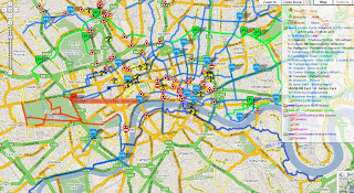
Camden Cycle_Map - Clickable Lines

Polygon Hit Detection

Detecting whether a clicked point is within a polygon is more straightforward, and less open to interpretation. We first draw a straight line from the clicked point to the right of the screen. Each time this test line crosses a segment of the polygon, it changes state from being inside to outside or vice-versa. If the test line crosses an odd number of segments then the point is determined to be inside the polygon, whereas if the test line crosses an even number of segments then the point must be outside.

Many of the same improvements for polylines in polygon detection, using the map viewport and zoom level to drastically reduce the number of segments to consider, and using a bounds tree to avoid performing unnecessary intersection tests.


Original Post modified here by Mapperz

Camden Cycle Campaign is one of the very first to use this functionality in full effect. Well done.

"Our primary aim is to get more people to cycle and to improve things for those who already do so."

Labels: , , , , ,

07 September 2007

VeoGeo Map (Video & Map Tracking)

VeoGeo Map (Video & Map Tracking)

VeoGeo Video Map Tracking

VeoGeo takes video sharing to the next level. Now you can map the activities you video, and share even more of the experience!

See what people from around the world are doing, and see where they’re doing it!

  • Capture your outdoor activities on your video camera
  • Capture a GPS record at the same time
  • Upload them to VeoGeo and share them with the world
This could take off with GPS and Video Capture on Mobile Phones.
The N95 could be used in conjunction with Sports Tracker and the 5 mega pixel camera.

VeoGeo Video Geotagged Map

As the video is played the map has a route and marker that moves in relation to the geographic position in the video. A nice touch is the graph that shows both speed/acceleration and elevation.

Labels: , , , ,

06 September 2007

Google Earth Allowed At Work!

Google Earth allowed at Work!

Google Earth at Work Now Allowed

Great News to users of Google Earth but the restriction is limited to Internal Use only.

Google End Users Licence Agreement (EULA)

Version 4.1 "You may not use the Software or the geographical information made available for display using the Software, or any prints or screen outputs generated with the Software in any commercial or business environment or for any commercial or business purposes for yourself or any third parties."

Version 4.2
"For a business entity user, the Software may be used by you and your employees for internal use"

"Google Earth Free finally becomes a proper universal browser of georeferenced data."
Ogle Earth

Mapperz see's this as a great way and potential improve Google Earth and make it into a Simple GIS.


Google Earth Release Notes
http://earth.google.com/support/bin/answer.py?answer=40901

What's the difference between Google Earth, Google Plus and Google Pro?

"Google Earth" is the free product for Windows (Vista, XP, 2000), Mac (OS X 10.4), and Linux

"Google Earth Plus" is the subscription-based consumer product, available for Windows and Mac only. You can
upgrade to Google Earth Plus via the "Help" menu of the free version of
Google Earth. This version is for non-commercial use only. It has all the
functionality of the Free version and adds the following features:
* GPS devices, including real-time tracking with NMEA
* Higher resolution printing
* Path Measure Tool
* Importation of .csv address files (limited to 100 points)
* Faster network performance

- "Google Earth Pro" is for professional use. It is available for Windows and Mac and includes all the features
in Plus and adds the following features:
* Polygon and circle measure tools
* Style templates (improve presentation of your data)
* Importation of .csv address files (limited to 2500 points)
* Data Importer
* Movie Making
* Very high resolution printing
* Email and chat support

"Google Earth EC" is the enterprise client.

Labels: , , , , , ,

05 September 2007

N95 Free Mobile Software (including Maps)

New N95 Free Mobile Software (including Maps)

reLive! Map London Demo

Nokia Download!
New
"Download! for PC enables you to discover mobile content using a PC. When you connect your mobile device to the PC, Download! for PC automatically synchronises with the corresponding software on your device. This makes it easy for you to find, download and manage content (maps) that is compatible with your device."
http://www.nokia.com/betalabs

Opera Mini 4 Beta v2
http://www.operamini.com/beta/
A Good Mobile Browser that allows you to view web based mapping now in landscape mode.

amAze 4.0
http://www.amazegps.com/index.php?page=countries&language=uk
The best Free Sat Nav For GPS enabled phones (includes N95)

Mosh Nokia New!
http://mosh.nokia.com/
"Your Stuff. Any Phone. Everywhere."
A good resource for finding and sharing Apps, Software,Music, Maps, Games, Pictures, Ringtones etc.

Local Search (Yell and Yahoo Search integrated with Map Option with results)
http://mobilesearch.nokia.com/A4160040


Mapperz Top Pick
reLive!
a unique and handy leisure application, allows you to take photos and write notes along your trip route, and seamlessly attach them to their locations on the map (geo-tagging).

reLive! Map

Demo ( in Flash)
http://relive.atlasct.com/map.asp
Download reLive! at
http://relive.atlasct.com/wap/ (via your mobile)

more info at
http://www.atlasct.com/Applications-ReLive.html

Labels: , , , , , , ,

04 September 2007

EuroStar Map

EuroStar Map including St Pancras International

"On Wednesday, 14 November 2007, Eurostar launches services from St Pancras International, our new home in the heart of London. Experience faster journeys on High Speed 1."

The Official Flash Map


View Larger Map
Mapperz 30 second version...


Waterloo continues to be a major hub in London's Public Transport Network but will not be an international station after 14th November 2007.

Labels: , , , ,

03 September 2007

Hurricane Felix


BBC News
http://news.bbc.co.uk/1/hi/world/americas/6974643.stm

Labels: , ,

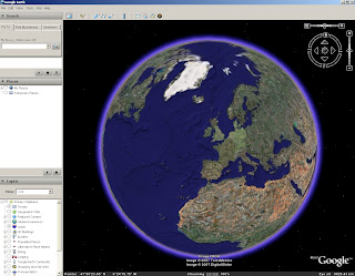
Google Earth Flight Simulator

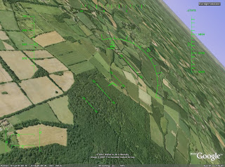
Google Earth Flight Simulator (was a hidden feature)

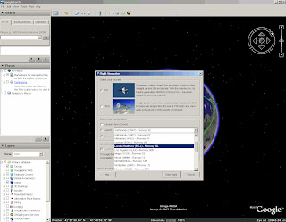
Flight Simulator Google Earth StartFlight Simulator Google Earth Flight

To open the flight simulator use
Windows Ctrl + Alt + A
Mac Command/Open Apple Key + Option + A


Keyboard Shortcuts
http://earth.google.com/intl/en/userguide/v4/flightsim/index.html
"Note that until you enter flight simulator mode, the following commands do not work."

Original Finder
http://marco-za.blogspot.com/2007/08/google-earth-flight-simulator.html

Labels: , , , ,