->

14 November 2007

New Draggable Geograph Map (Beta)

New Draggable Geograph Map

Geograph Map just got easier to use...

Geograph Draggable Map Beta
New draggable maps using Ordnance Survey 1:50,000 mapping (Landranger series)
What is Geograph?
"The Geograph British Isles project aims to collect geographically representative photographs and information for every square kilometre of the UK and the Republic of Ireland, and you can be part of it."

Draggable Geograph Map of Great Britain (beta)

64% complete for the British Isles
http://www.geograph.org.uk/numbers.php

How is this done?
Servers “Jam” “Toast”, “Scone” and “Crumpet” (a good start to any day)
http://blog.dixo.net/2006/07/28/geograph-servers-coming-to-life/

This site uses an Educational Licence from the Ordnance Survey
"Great Britain 1:50 000 Scale Colour Raster Mapping © Crown copyright Ordnance Survey. All Rights Reserved. Educational licence 100045616."

How is the done?
"But basically it just (JUST!?) involved cutting up 12GB of raw tiff files from the
OS, into more manageable png chunks using imagemagick, and then on
demand but cached on disk it cut into png tiles. The overlay is also
generated in php, ondemand and cached with memcached. And of course it
using openlayers as the client library."
Barry Hunter (nearby.org.uk)

Mapperz thanks Barry for sharing his time and tweaks on this. Well done and keep up the good work.


Just a quick note to UK Teachers out there - the 16th November is the last date to get Free Ordnance Survey Maps (for 11 year olds)
http://freemaps.ordnancesurvey.co.uk/freemapsfor11yearolds/

Labels: , , , , , , ,

25 September 2007

MultiMap Open API + Ordnance Survey Data

MultiMap Open API + Ordnance Survey Data

Ordnance Survey 1:50,000 Data is now accessible to API developers

is it true?

You can Zoom in and Pan.

A bigger version is available here
http://mapperz.googlepages.com/Multimap_Sample_OS50k_bigger.html

"At Multimap we’re [they are] very proud of the wide range of local and global mapping data available on our website and through our API, and are committed to providing as much of this data via the Open API as we [they] can. To that end, we’re very pleased to announce the availability of Ordnance Survey Landranger maps (at 1:50000 scale across zoom levels 13, 14 and 15) through the Open API.

The Landranger data covers England, Scotland and Wales and provides a wealth of topographic features, such as contour lines, tourist attractions and historic features such as Roman roads. These maps are great for walkers, cyclists, or for providing detailed maps of rural areas. We can’t wait to see how people make use of them through the Open API."


http://blog.multimap.com/


A good but probably expensive (regards to licensing) move by Multimap.

Mapperz

Labels: , , , ,

12 September 2007

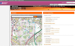
Ordnance Survey Explore (Beta)

Ordnance Survey Explore

OS Explore Beta

Ordnance Survey have launched 'OS Explore', a website designed for walkers, runners, hikers, cyclists, anyone with the interest with the great outdoors and sharing their routes and personal favourite places.

OS Explore Route

Though there is room for improvement:
  • No Help or FAQ - to get non map people to 'get started'
  • No Editing of your own routes (that's a bit silly)
  • No 1:25,000 (Explorer) Mapping is all 1:50,000 (Landranger) (OS have copyright on their own data surely?)
  • No Polygon creation (Area) - only Lines and POI Points.
  • No Export so cannot use the route in a GPS

Well it's a start from the Ordnance Survey - but clearly in Beta.

Needs to be more 'MyMaps' in functionality

Add your comments on the service - maybe they take note, maybe not.


*Routes are British National Grid not WGS84

Ed Parsons (ex Ordnance Survey) also mentions it in his blog

Official Reply on the editing of routes
"Unfortunately, at the current time, users are unable to edit routes once they have been saved. However, before saving, users are able to undo waypoints they have plotted and remove their points of interest. There are several usability changes envisaged for the next release and this is an area we would like to see improved. The site is still in its beta stage so obviously we are keen to hear about any issues encountered."

Labels: , , , , ,