->

28 August 2009

BBC Breathing Places Maps

BBC Breathing Places Maps
BBC Breathing Spaces Maps
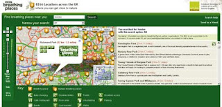
A nice and clean friendly Google Maps with simple icons to guide you to "BBC Breathing Places"

"Breathing Places has some brilliant ideas for rolling up your sleeves and making your very own place for nature – right on your doorstep."

We [The BBC] want to help you get friendlier with wildlife and give you lots of ideas on how you can do just that.

Enjoying the outdoors will do you some good and, as long as you're careful, you will do some good for wildlife as well. It's as simple as doing one thing, no matter how big or small that one thing is. Or if you're really keen you can do lots and lots of one things.

Map Tips:
You can use the drop down menu so your search only shows places with events/ walks within the next week/month, places that need volunteers or places with a particular event theme.
Icons:
Click a single leaf icon to see a bubble with info/links for that place. Multiple (tiled) leaves indicate several places. If the places are too close together to show separately, clicking the leaves shows a bubble with a list of places. If there are too many places to show, clicking the leaves will zoom the map in.

Example Map:
http://www.breathingplaces.org/public/search?location=London&has_js=1&Search.x=0&Search.y=0

Help Guide (for the Map)
http://www.bbc.co.uk/breathingplaces/help.shtml

**Database developed in collaboration with Natural England

Full A to Z of all the 'Places' available currently.
http://www.breathingplaces.org/public/browseplaces/a

For Teachers
http://www.bbc.co.uk/breathingplaces/schools/

Coming Soon is Breathing Places Communities
http://www.bbc.co.uk/breathingplaces/communities/

Labels: , , , , ,

26 August 2009

Google Map Static Map Upgrade (v2)

Google Map Static Map Upgrade (v2)

New Features Encoded Paths, Polygons & Geocoding

update:
here is a useful tip or two using 'MyMaps' created features:
http://imagine-it.org/google/staticmap/encodemymap.php
(thanks to @pamelafox)

Google have made some changes - many top requested features have been included, but due to these feature requests there are some changes required for you code.

  • Locations (in center, markers, or path parameters) can now be specified as addresses instead of latitude/longitude coordinates.
  • Paths can be specified as encoded polylines.
  • Paths can be filled and rendered as polygons.
  • Colours can now be specified as any 24-bit or 32-bit colour.

Use of the Google Static Maps API is unchangedwith a query limit of 1000 unique (different) image requests per viewer per day

Google Static Maps v2
encoded polygon in Google Static Maps v2

http://maps.google.com/maps/api/staticmap?size=400x400&path=fillcolor:0xAA000033|color:0000ff|enc:ykfyHln@bBtLhJkI|JyGdChAzHiL
|BfBvH}IlEvCl@tG%60@rGYjIXbLpApEbC_@a@kJ~@cUpB_@tH~D~FzG%60Eg@
qAeK[iGvBgEeDwB%60A}EuFwA|AqGvG_D?_QdDiJgAiElCuOkGuC_I_Is@iK|
AuFz@_GYuGuEj@{PtG_CTbA~OsJKa@sFcH?XrVQhGi%60@dj@zDdVwRdPrCbO
&key=YOUR API KEY&sensor=false


Note: The fastest way to create an encoded polygon is to create a polygon in Google Earth then right click the polygon and copy & paste into this site

http://facstaff.unca.edu/mcmcclur/GoogleMaps/EncodePolyline/encodeForm.html
check your polygon is located correctly. The click then 'Show Code'
The line {points:
contains the encoded polygon. use this for your static map.

Having been re-written The Static Maps API v2 changes are:

red=old green=new
  • Instead of specifying maptype=mobile, specify the desired map type (like maptype=hybrid) and the parameter mobile=true. This way, we can provide mobile optimised tiles for every map type.

  • The colour for a path is now specified using "color", not "rgba":

    For example:
    &path=rgba:0x0000FF80,weight:5|37.40303,-122.08334|37.39471,-122.07201|37.40589,-122.06171
    becomes:
    &path=color:0x0000FF80|weight:5|37.40303,-122.08334|37.39471,-122.07201|37.40589,-122.06171

  • Similar to how the path styles were specified before, the marker styles are now specified using key:value pairs, separated by pipes [|]. Marker labels are now denoted using uppercase alpha characters instead of lowercase alpha characters.

    For example:
    midreda
    becomes:
    size:mid|color:red|label:A

  • Instead of specifying the marker style after each marker parameter, specify the style at the beginning of the markers= parameter, and that style will apply to all of the markers proceeding. If you want to show markers with different styles, just supply a new markers= parameter for each one.

    For example:
    markers=37.400465,-122.073003,midreda|37.437328,-122.159928,midreda|37.369110,-122.096034,smallblue
    becomes:
    markers=size:mid|color:red|label:E|37.400465,-122.073003|37.437328,-122.159928&markers=size:small|color:blue|37.369110,-122.096034

  • Marker labels now require uppercase alphanumeric characters in the label parameter. This will allow us to later supply lowercase characters if we wish.

    For example:
    markers=37.400465,-122.073003,midreda
    becomes:
    markers=size:mid|color:red|label:E|37.400465,-122.073003

  • Instead of using the span=parameter to make sure that your static map shows a particular viewport, use the visible= parameter instead, and specify a list of coordinates that must be shown.

    For example:
    center=0,0&span=20,20
    becomes:
    visible=10,-10|-10,10

  • The frame parameter is no longer supported.

After upgrading your existing functionality, you might be interested in adding some of the new API functionality to your website.

Tools: Make A Static Map Wizard (V2)

http://gmaps-samples.googlecode.com/svn/trunk/simplewizard/makestaticmap.html

Source:

http://code.google.com/apis/maps/documentation/staticmaps/upgrade.html

Labels: , , , , , , ,

25 August 2009

Open Street Map gets Official Isle of Man Data

Open Street Map gets Official Isle of Man Data

The OpenStreetMap gets a pleasant boost for #OSM Mappers for the Isle of Man.

This is excellent to see. Encouraging for the whole aspect of the project.

Isle of Man 1:25000
OpenStreetMap now has access to Isle of Man Government 1:25,000 data - this contains much detail that can be used to improve the already abundant data in OpenStreetMap.

OSM now has access to two datasets from which can be derived from for the project:
  • the 1:25,000 tourist map (2007) [above], provided as a set of four GeoTIFF images
  • the high resolution aerial imagery (2001) [below], provided as a set of three MrSID images

Isle of Man Aerial Imagery
High Resoultion imagery will help capture detials with out the leg work, and anyone can help contribute to the data capture.

"There is a massive amount of information which we can gain from these datasets still, and I will be posting some ideas soon about different possibilities, such as collecting place names, paths and tracks, historic sites, outlines of the national glens, open rambling land, etc. as well as using the data for error checking and correction in the existing OpenStreetMap dataset.

I am planning to make these datasets available as a WMS server that can be used in JOSM (and Potlatch) for editing, once I've had a chance to organise it, and have had an official license document through."

Dan Karran


Isle of Man Aerial Imagery & 1:25000 overlay

This is a good way to see cartographic features and imagery overlaid - making digital data capture much easier for users.

acknowledgement:

Isle of Man Government map data and aerial imagery © Crown Copyright, DLGE; OpenStreetMap data © OpenStreetMap and contributors, CC-by-SA.

Now would the UK Ordnance Survey allow this? I think not.

source and more information:

http://www.dankarran.com/blog/2009/08/using-official-isle-of-man-map-data-in-openstreetmap

Labels: , , , , , , ,

24 August 2009

The Hot Tube [underground] Map

The Hot Tube [underground] Map

London Underground Tube Hotspots Temperature Map

Transport for London have release a snapshot of the temperatures that were recorded July 28th - July 29th 2009.
Central Line was the hottest with temperatures up to 32C.

Temperatures seem to be at the highest during 4pm and 7pm


"TfL have revealed the hottest spots on the London Underground to identify the areas which need the most cooling. The heat map compiled on July 28 - one of the hottest days of the year, showed the Central Line was the warmest. Luckily it was already coloured red. That part of the network was above 30C (86F)."

(In previous tests , temperatures in some parts during the summer have exceeded 35C, which would make the network officially unfit for transporting cattle.)


Now if only there was a live version of the map, in real-time.

The Map 'undegroundhotspots' (in PDF format)
http://extras.timesonline.co.uk/pdfs/undergroundhotspots.pdf

source:
http://london-underground.blogspot.com/2009/08/tube-map-shows-hottest-spots.html

Labels: , , , , ,

20 August 2009

192.com Aerial Imagery Updated

192.com Aerial Imagery Updated

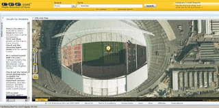
192.com have updated the to most up-to-date online aerial photography for London.
High Resolution aerial photography from Getmapping.com
The new imagery has been captured using the latest digital camera technology with each image pixel equivalent to 12.5cm from the ground. The result are high quailty true-colour photographs - right down to road markings and visable street furniture.

This data is more up to date than google 'satellite' mode and microsoft bing aerial (multimap) mapping sources.

192.com Aerial Mapping Updated

New orthorectified aerial images on 192.com include Wembley Stadium including the Wembley Arch and Wimbledon’s new multi-million centre court roof. Also visible on the new photography is the beginning of the preparations for The Ashes Test Matches at Lords and the Oval Cricket grounds.

"This new photography shows a step forward for aerial imagery used on the net and we believe it will help our users to get richer search results and a more enjoyable experience. The images are truly amazing and even let people check out the most recent aerial shots of their home."
Dominic Blackburn - Product Director

Check the new updated aerial photographs
http://www.192.com/places/


A couple links to some well know landmarks:

Buckingham Palace
http://www.192.com/places/search/?Type=All&place=BUCKINGHAM%20PALACE&gre=529168&grn=179747
(includes Super Zoom Mode)

Wembley Stadium
http://www.192.com/places/search/?location=wembley%20stadium&distance=1838&page=1&searchType=All&place=WEMBLEY%20STADIUM&gre=519384&grn=185519

source:http://www.journalism.co.uk/66/articles/535540.php
& email - thanks to Neil Watts - neil.watts@192.com

Labels: , , , , , ,

18 August 2009

Google Maps News - Street View & Map Maker

Google Maps News - Street View & Map Maker

update:19/09/09
Mexico is now available for Map Maker - please see the official blog post
http://google-latlong.blogspot.com/2009/08/map-maker-goes-west.html

StreetView has been expanded again this now covers
Switzerland and Portugal and also Taipei City in Taiwan

New Street View Chapel Bridge, Lucerne
Chapel Bridge, Lucerne with new Streetview coverage.

Google Maps Mania does a very good round-up of the coverage included
http://googlemapsmania.blogspot.com/2009/08/street-view-arrives-in-switzerland.html


Google Map Maker has been opened up some more with download-able vector data available for Africa [Terms of Use Apply]. This is either in KML format or Shapefile.

On the Mapmaker creation side Eastern Europe has now been opened up for editing.
This includes Albania, Belarus, Kosovo, Macedonia, Moldova, Montenegro, Romania and Serbia.
More news on this here
http://google-latlong.blogspot.com/2009/08/map-maker-gets-european-flair.html

Map Maker Africa Download
This data can be obtained by accepting the terms of use at this link
https://services.google.com/fb/forms/mapmakerdatadownload/
This data can be used in a GIS or Google Earth Application.

Labels: , , , , , , , ,

17 August 2009

Easy OpenStreetMap Editors

Easy OpenStreetMap Editors


One early frustration with wanting to help the OpenStreetMap project was how do you edit the data easily?

OpenStreetMap has lot and lots of data already, though more and more people are required for their local knowledge and to do the mamouth task of keeping the 'map up-to-date'

Well there are lots of different applications from online editors to compiled source code are out there. Which is easiest and user friendly?

These two are mapperz best picks

Merkataartor (v0.14) - fairy new software - but nicely laid out user friendly. Has great potential and is supported by most OS
see the list
http://wiki.openstreetmap.org/index.php/Merkaartor#Download
http://www.merkaartor.org/Download/

Small download, very simple to use - download by area/map of your choice.
No knowledge of OSM to start using. (But advise you to research first)
uploading does require a osm account so you can contribute but downloading and viewing data (in cartographic map-form) does not require a login.
Merkaator Yahoo Imagery - London Bridge

Software is updated regularly and many features have been added - recently Area digitising and tagging tools have been introduced.
Offline mode.
Map Style mode - set one from the list or make your own.
Documentaton: http://wiki.openstreetmap.org/index.php/Merkaartor_doc_0.12
(requires an update to v0.14)


Potlatch - long standing Open Street Map 'online editor' but now more user friendly than ever (thankfully).
Back along mapperz liked the idea of editing in a browser (as all GIS will be in the future).
But Potlatch back then was slow,buggy and choked the browser up - all those issues are long gone and now it is a really fast and easy way to edit 'live'.

Potlatch POI drag and drop editing
Potlatch has greatly increased productivity due to the 'drag and drop' POI (Points of Interest) tool. Tip you reuse tag names with the 'r' button (repeat tag) remember to give as much infomation as you know.
Note: There are many tag names (too many to list) please visit
http://wiki.openstreetmap.org/wiki/Map_Features
for a full list of tags.

Yes, there are many, many other OSM editors out there but this is for the curious potential new user, that just wants to help out.

others:
JOSM is currently the most popular desktop editor. It is a standalone Java application (requires Java 1.5) which allows fluid zooming, panning, and editing of a locally stored dataset, before uploading changes in a batch.

OSM2Go is a mobile mapping solution currently supporting the Nokia Internet Tablet family (N800 & N810), can also be compiled for the Linux/GTK+ desktop.

Vespucci [1] for android devices.

Amenity Editor is a simple online editor for creating and editing nodes and POIs. (ATM only in German)
source:
http://wiki.openstreetmap.org/wiki/Editing

Labels: , , , , , , ,

14 August 2009

ArcExplorer (build 900) - GIS for Everyone finally...

ArcExplorer (build 900) - GIS for Everyone finally... who has a pc'

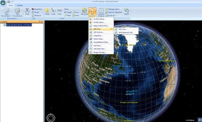
There has been quite a wait for this version of ArcExplorer from ESRI. Though finally a product that can be used by all users.
Think along lines of Microsoft Office now has a geo-spatial browser.

ESRI ArcExplorer (build 900)
GIS for Everyone finally...

What is new and why it is finally a useful product?ArcExplorer Import Content
  • New User Interface (very Microsoft Office ribbon like)

  • GIS analysis (such as visibility, direction finding, and proximity search)
  • GeoRSS feeds import
  • New basemap galley for easy access to different base maps
  • 2D/3D modes now caters for the 2D map perspective.
  • Improved KML support and support for layer packages (.lyr support & the .lpk introduced at ArcGIS 9.3.1)
  • GPX data import
  • JPEG 2000, GeoTIFF, MrSID import
  • New presentation mode - useful for presentations.
  • Bing Maps *free to ArcGIS Desktop users - Though visit Bing Maps to view for free.
  • Localisation - dependant on your language
  • Projections - Expansion package required.
Other notes:
ArcGIS Explorer SDK (direct link to .exe file) - 24.5mb
"For developing custom add-ins which extend the capabilities of ArcGIS Explorer. Requires Visual Studio .NET. Note: The SDK must be installed after installing ArcGIS Explorer. For more information read the ArcGIS Explorer SDK Installation Guide"

Optional Expansion Packs:
(direct links to .exe files)

Data Access Expansion Pack (9.9mb)
Expands geodatabase functionality by allowing direct connections to multi-user geodatabases

Fonts Expansion Pack (2.7mb)
Adds more ESRI fonts for use with ArcGIS Explorer. ESRI fonts are used when displaying ArcGIS Layer files and Layer packages.

Projection Engine Expansion Pack(15.2mb)
Adds more projections and geotransformations for use with ArcGIS Explorer

Source:
http://blogs.esri.com/Info/blogs/arcgisexplorerblog/archive/2009/08/13/what-s-new-in-arcgis-explorer.aspx

Official Page:
http://www.esri.com/software/arcgis/explorer/index.html

What's New Guide (with video)
http://www.esri.com/software/arcgis/explorer/whats_new.html

Demos:
http://www.esri.com/software/arcgis/explorer/demos.html

System Requirements
http://www.esri.com/software/arcgis/explorer/system_requirements.html

Download Page:
http://resources.esri.com/arcgisexplorer/900/index.cfm?fa=home
(the main program is 78.4mb)

@Mapperz

Labels: , , , , , , ,

12 August 2009

BBC Crime Map - Truth About Crime

BBC Crime Map - Truth About Crime

"A unique experiment uncovering crime in a typical British city"

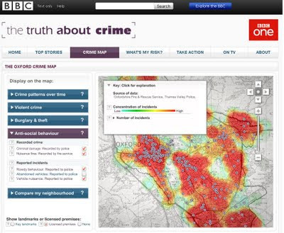
The BBC have chosen Oxford, England because it is as close as they could find to a typical British city. In terms of demographics, and particularly in terms of levels and types of crimes, it is typical of the national picture.

Truth About Crime BBC Heat Map
Heat maps with 'licenced' premises

In making this website and the accompanying television series the BBC worked closely with Thames Valley Police. Oxfordshire Fire & Rescue Service, Oxfordshire County Council Trading Standards Department, Oxfordshire Domestic Abuse Services, South Central Ambulance Service, the John Radcliffe Hospital, and Oxford's Crime & Disorder Reduction Partnership, who supplied the BBC with the original data.

Data Currency:
The data covers the year from November 2007 to November 2008

Why Heatmaps?
'heatmaps' are used to display the crime data, since these offer a clear way for users to see patterns of crime, without requiring users to have the expert knowledge of crime data analysts.

Want to create your own heatmap?
Try - http://www.heatmapapi.com/

View the BBC Heat Map for Oxford
http://www.bbc.co.uk/truthaboutcrime/crimemap/

Labels: , , , , ,

11 August 2009

Google Web Elements - Google Maps

Google Web Elements - Google Maps

Very simple, very quick to publish maps with your location. No need to write code.

Google Maps - Web Elements Maps
Simply add your location (it checks location can be found) - then select map type and size - code is copied and pasted into your own site.

"Web Elements allows your customers to enhance their websites with the ease of cut-and-paste. Webmasters can provide maps, real-time news, calendars, presentations, spreadsheets and YouTube videos on their sites. With the Conversation Element, websites can create more engagement with their communities. The Custom Search Element provides inline search over your own site (or others you specify) without having to write any code"


A simple slippy (interactive map) with out writing any code....

More Google Web Elements
http://www.google.com/webelements/

http://www.google.com/webelements/maps/
for more advanced features (multiple locations)

Labels: , , ,

10 August 2009

Geographic Imager for Adobe Photoshop

Geographic Imager for Adobe Photoshop:


The Geographic Imager for Adobe Photoshop CS3 and CS4 allows you
to access all the tools and functions quickly and easily for
Imagery Manipulation (Remote Sensing).

Retain spatial properties

Geographic Imager allows the use of Adobe Photoshop native
functionality without destroying the spatial properties of an image.

Import/Export imagery

Import and manage georeferenced imagery such as GeoTIFF, JPG, PSD and
other Photoshop compatible raster data formats.
Export reference files as standard industry formats.

Import elevation data

Now import DEM formats such as ArcInfo ASCII Grid, ArcInfo Binary Grid, DEM USGS/CDED ASCII, Military Electations Data/DTED and SRTM. Also new support for other formats such as

ECW, JPEG 2000 and MrSID.

Georeference non-referenced imagery

Import or add ground control points for accurate georeferencing of images with multiple transformation types supported. Save GCP data as reference files. Quick reference using one or two tie-points.

Mosaic

Mosaic individual images to create a seamless image. Retain images as separate layers or flatten to create one image. Now supports image transformation during Mosaic, making it easier to get the images the way you want. Also, now create seamless mosaics of images with different coordinate systems, pixel sizes, channels and colour modes.

Tile

Tile an image into multiple images by tile size or count. Automatically saves tiles using sequential naming.

Crop

The GeoCrop tool allows image cropping based on a combination of pixels or geographic coordinates (geodetic and projected). Also GeoCrop Import lets you crop images before they are opened.


Merge and Split Channels

Adobe Photoshop Merge and Split Channels are now supported. Create false- and true-colour images while retaining georeferencing.

Scripting

Allows for use of Geographic Imager tasks in conjunction with Adobe Photoshop automation tools.

Cost:
Geographic Imager Full Version
* version 2.x for Adobe Photoshop CS2*, CS3 & CS4
$699 (£419**)
Geographic Imager upgrade
* from version 1.x to 2.x
$319 (£191**)
Geographic Imager Floating licenses

* US$1,599 for each concurrent user when 1 to 4 licenses are purchased
* pricing available for 5 or more concurrent users.
$1,599 (£959**)
Geographic Imager & MAPublisher bundle

* Geographic Imager 2.x and MAPublisher 8.x
$1,749 (£1,049**)
* Adobe Photoshop CS2 users require Geographic Imager 2.0
Shipping
All products are shipped by UPS by default. If you prefer another method or to have the shipping charges billed to your account please indicate so when ordering. All prices are shown in U.S. dollars ($USD). Shipping charges (for a single item) are as follows:

* Economy delivery to anywhere in the US and Canada — $35
* Overnight delivery to anywhere in the US and Canada — US$55
* Delivery to anywhere in Western Europe — $85 (£51**)
* Delivery to most other places — $120
** price correct/conversion on 10/08/2009
Image Sources: http://www.avenza.com/geographicimager

Labels: , , , , , ,

06 August 2009

BBC Sport: World Cup 2010 Map - South Africa

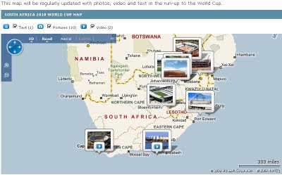
BBC Sport have launched the 'World Cup 2010 Map - South Africa Map'

Use the map to explore preparations for the 2010 World Cup in video, audio, pictures and text.

BBC Sport World Cup 2010 Map

One first load, the map shows all 10 World Cup venues in South Africa.

Click on a pictures to find out more about the venue in question. Use the map's controls, in the top left-hand corner, to zoom in and discover more venues.

This map will be regularly updated with photos, video and text in the run-up to the World Cup 2010

Source & Map
http://news.bbc.co.uk/sport1/hi/football/8094737.stm

Labels: , , , , ,

03 August 2009

Cloudmade: Directions Africa Cape Town to Ethiopia

Cloudmade: Directions Africa Cape Town to Ethiopia

OpenStreetMap gets a boost with capable directions now across Africa


Africa Directions from Cape Town to Ethiopia click 'Hide' view the map route on the map.

view the url:
http://maps.cloudmade.com/?lat=-9.622414&lng=11.25&zoom=3&directions=-33.914731015167575,18.423986434936523,
3.5024553022772564,39.056396484375&travel=car&styleId=1

Other Cloudmade news
http://blog.cloudmade.com/
CloudMade partners release new mobile libraries

Raster Libraries

Vector Libraries

Nutiteq have long been a trusted CloudMade partner providing mobile libraries. They have now added CloudMade support for two leading mobile platforms - Blackberry and Android. Blackberry commands a high worldwide market share for smart phones and is the leading platform for email and enterprise. Google’s Android has set a new bar for open source mobile OSes, and we expect a number of new handsets to come to market during the remainder of this year. Both libraries give access to a full range of CloudMade services including custom image tiles, geosearch and routing.

Labels: , , , , ,