->

30 May 2011

Open Street Map Linked GeoData

Open Street Map Linked GeoData (RDF)

Making geographical data more discoverable and accessible:
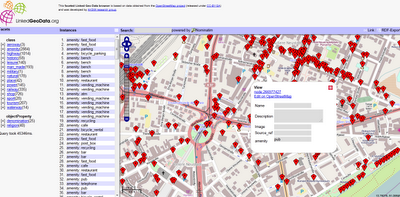
Open Street Map Linked GeoData


LinkedGeoData is an effort to add a spatial dimension to the Web of Data / Semantic Web. LinkedGeoData uses the information collected by the OpenStreetMap project and makes it available as an RDF knowledge base according to the Linked Data principles. It interlinks this data with other knowledge bases in the Linking Open Data initiative.


The Linked Geo Data Knowledge Base

"In order to employ the Web as a medium for data and information integration, comprehensive datasets and vocabularies are required as they enable the disambiguation and alignment of other data and information. Many real-life information integration and aggregation tasks are impossible without comprehensive background knowledge related to spatial features of the ways, structures and landscapes surrounding us."

LinkedGeoData uses the comprehensive OpenStreetMap spatial data collection to create a large spatial knowledge base. It currently consists of information about approx. 350 million nodes and 30 million ways and the resulting RDF data comprises approximately 2 billion triples. The data is available according to the Linked Data principles and interlinked with DBpedia.

Accessing the data:

The following interfaces exist for online access:

  • Rest Api: provides basic access to a database with a full Open Street Map (OSM) planet file loaded.
  • Sparql Endpoints: enable queries on databases with a reduced (but hopefully for many applications relevant) subset of the whole data loaded. The Sparql Endpoints come in two flavours:
    • Static: Contains the data extracted from a OSM planet file of a certain date
    • Live: Initially a copy of the static version that is then synchronized with the minutely updates from OSM.

Example Link
http://browser.linkedgeodata.org/?lat=51.063657689874&lon=13.750735172091&zoom=16&prop=amenity&val=

Access to the Data
http://linkedgeodata.org/OnlineAccess

Labels: , , ,

10 March 2011

OpenEcoMaps

OpenEcoMaps provides free eco-living maps and data from OpenStreetMap

.OpenEcoMaps


OpenEcoMaps Exeter,UK
But why?

There are lots of community groups, councils and companies out there mapping allotments, renewable energy generators, cycle routes and more. But they all suffer from two shortcomings:

1. Duplication - by putting their work into different places, different maps, we're duplicating effort and not benefiting from each other's work. For example, it's common to find several different people all trying to map food growing spaces in the same part of town. Why not share?
2. Tools - not everybody has the tools to map these things, to put the results onto their web site or provide it to their council in the correct format.

OpenEcoMaps encourages people to share all their data in the same place - OpenStreetMap - and makes it easier for you to make use of the results.
How does it work?

OpenEcoMaps takes the data from OpenStreetMap (published under the Creative Commons Attribution-Sharealike 2.0 license), a community that is mapping the whole world and providing all of the information as open data. It takes a fresh data extract every hour and turns it into reusable KML Files, which can easily be displayed on a map.

Map of Exeter includes:
  • Cycling Map
  • Public Transport
  • Aerial Photography
  • Food growing
  • Zero Waste
  • Sustainable Transport
  • Low Carbon Power
http://www.openecomaps.co.uk/map.php?pack=TTE&zoom=1&lon=-3.51&lat=50.72

Source:
http://tom.acrewoods.net/2011/03/09/growing-pains-getting-data-out-of-openstreetmap/

More information:
http://wiki.openstreetmap.org/wiki/OpenEcoMaps
http://www.openecomaps.co.uk/about.php

Labels: , , ,

28 January 2011

Paris Open Data Released

Paris Open Data Released
Paris OpenData in many different data types.

The data held by the City of Paris are fully exploited by the municipal services as part of their missions, but are also an intangible heritage that can be developed for the whole community:
  • researchers can find material to feed their work and experiences,
  • developers can create innovative services using these data,
  • citizens and journalists to find raw information,
  • companies can provide added value to these data, and thus create jobs and wealth for the community.

The movement "Open Data" (open data) is to get any type of structure, including local authorities around the world, the provision of all, free and free of electronic data. More Data to come in the weeks.

Now map it.
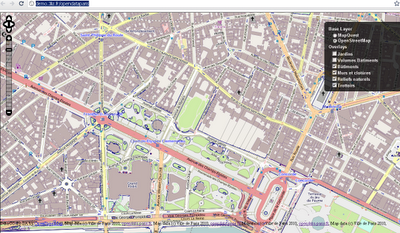
Paris Open Data Released in Open Street Map
Already in OpenStreetMap - http://demo.3liz.fr/opendataparis

Labels: , , ,

16 November 2010

MapQuest Embed Two OSM Editors

MapQuest Embed Two OSM Editors

MapQuest are getting ahead of the rest with an instant online OSM (Open Street Map Editor
MapQuest Potlatch 2 embedded OSM Editors

If you know the area and spot an error on the http://open.mapquest.com sites you can now edit directly using the Potlatch 2 Editor without too much trouble.

Mapquest are pleased with themselves: (and why not?)

"We’ve done it again! Updates are fast and furious on our MapQuest Open sites, powered by OpenStreetMap data. Just this week, we’ve released new edit buttons, ‘send to website’ and ‘right click’ to find the closest thing in your map display.

Our new edit button is really three different edit button or links: below the search result & top right of your map; and edit links that are built into the popup information box. The popup information box allows you to choose which OSM editor you want to use in order to edit the location (or surrounding area). Your two edit tool choices are Potlatch 2 (hosted by MapQuest) or JOSM (known as the “Java OpenStreetMap Editor”). Potlatch 2 uses a GUI user interface for easily making edits whereas JOSM allows you to download chunks of the OSM data onto your desktop to edit and then upload the newly changed data back onto the OSM servers for processing. (Note: be sure JOSM is already installed and running when you click the JOSM edit link.)"

http://blog.mapquest.com/2010/11/11/latest-updates-on-open/

Quite an achievement for both MapQuest and OpenStreetMap

Full Details

http://open.mapquestapi.com/dataedit/

Labels: , , , , ,

02 November 2010

Isle of Man Maps (OpenStreetMap Series)

Isle of Man Maps (OpenStreetMap Series)

Full Credit goes to Dan Karran

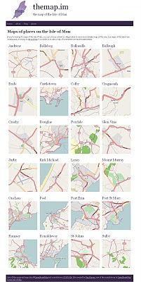
Isle of Man Maps (OpenStreetMap Series)
Using OpenStreetMaps to create a series of maps for the Isle of Man. Image via BBC News

From BBC News

For the first time a comprehensive series of Isle of Man maps have been made available online.

The project has taken Manxman Dan Karran around five years so far and is not finished yet.

In the next stage he will add features like woodland, streams, footpaths, parks, tourist attractions and shops.


Isle of Man Maps Places (OpenStreetMap Series)
Isle of Man Places

http://themap.im/places


"The maps got some great coverage with a BBC Isle of Man article, which has generated a good amount of interest in the site. The more people the map is available to, the sooner we can iron out any issues in the map data. There may be the odd typo, things accidentally added in the wrong place, or things that are missing completely, so all feedback is welcome.

For me, building this site is a great opportunity to use Drupal to help promote OpenStreetMap data, using the OpenLayers mapping library (and Drupal module) to display the maps on the site, and I'm looking forward to building the site out further."

http://www.dankarran.com/blog/2010/11/new-maps-of-the-isle-of-man

Original Source
http://news.bbc.co.uk/local/isleofman/hi/people_and_places/newsid_9132000/9132086.stm

Labels: , , ,

26 October 2010

Evolution: European OpenStreetMap

Evolution: European OpenStreetMap

Evolution of European OpenStreetMap coverage from skobblertutorials on Vimeo.

Hence why Mapquest(Open) and Bing Maps (OSM App) are becoming more mainstream

Labels: , , , , ,

18 October 2010

Open Street Map Potlatch 2 Public Alpha

Open Street Map Potlatch 2 Public Alpha

Major changes in the interface for editing Open Street Map online.

"You know it. You love it. It's the editor on the main OSM web site. It's Potlatch and it's had some serious renovations. It's so new that now it has a new name, "Potlatch 2". But before Potlatch 2 can go live on the OpenStreetMap web site, it has to be put through it's paces. After more than a year of development, Potlatch 2 is a complete re-write of Potlatch. It has new features too numerous to mention, but for the most important feature; it is an editor for OpenStreetMap. So let's test it. "

Open Street Map Potlatch 2 Public Alpha
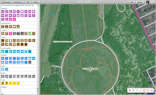
Editing is made easier with the legend based editor. Now based in Flash [Potlatch 2 is written in ActionScript 3 using the Flex framework] and more stable than its predecessor.
Backgrounds are easier to control (OS Streeview OpenData shown above)

Open Street Map Potlatch 2 POI
Point of Interest editing (Image source: OSM Wiki)

Try it you might like it.
If you want to test this new editor that is now in public alpha you can at
http://geowiki.com/

Hopefully this will be implemented in the Open Street Map main site soon.

Techies might be interested to know that this can deployed on your own website.
http://wiki.openstreetmap.org/wiki/Potlatch_2/Deploying_Potlatch_2

Labels: , , , ,

19 August 2010

Open Street Map Routing, Directions & Export

Open Street Map Routing, Directions & Export

OpenStreetMap (OSM) gets even more powerful with directions and routing tools.

Find, View and Export your custom directions
.

Designed Routes for:
  • Car
  • Heavy Goods Vehicles
  • Goods Vehicles
  • Public Service Vehicles (Buses)
  • Motorcycles
  • Bicycles
  • Pedestrian
  • Moped
OSM Powerful Route Finder
Simply have a start and end location - midpoints/waypoints can be included.

OSM Directions of Route
Directions 'explain' your routes, like a satnav would, turn by turn, includes all road names.

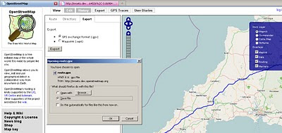
OSM Export Your Route
Export, a very useful component lets you export in GPS exchange format (.gpx) or waypoints (.wpt) format.

The map with route (above) example:

http://nroets.dev.openstreetmap.org/demo/index.html?lat=54.6&lon=-3.8&zoom=5&layers=B000TTTTT&v=motorcar&adj=recommended&markers=!50.06626%2C-5.71482!58.64026%2C-3.06984

Click 'Recommended' to calculate the route.

Labels: , , , , ,

16 August 2010

Open Layers Heatmaps

Open Layers Heatmaps

"Making Open Street Maps even hotter!"

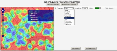
Open Layers OSM Heatmap
A Great Mashup to show 'HeatMaps' using Open Layers and Open Street Map Features (OSM).
Select a number of OSM Features and create dynamic heatmaps from them.
Note: this is the 'inverted' heatmap view.

Credit to Felipe Barriga (http://blog.felipebarriga.cl/)

If you want to create your own HeatMaps the source code is available via OLHeatmap.


What is OLHeatmap ?

OpenLayers Heatmap is a group of hacks ( talented programmers) to render heat maps over OpenLayers. At this moment is very ugly and dirty but I have some ideas in mind to make this a more presentable project....

Why that name ?

OLHeatmap stands for OpenLayers Heatmap

Video Demo


Video via http://opengeodata.org/osm-heatmaps-in-the-browser-w-openlayers

Heat Map
http://blog.felipebarriga.cl/olheatmap_demo/

Source:
http://blog.felipebarriga.cl/programacion/olheatmap-live-demo/

Labels: , , , ,

10 August 2010

MCZ Project Interactive Map

MCZ (Marine Conservation Zone) Project Interactive Map

MCZ Project Interactive Map
Find a huge amount of maritime information, this example shows bathmetry and ship wrecks along the coast of the SW England..

But this map project goes much further:

This project has been jointly funded by Defra, Natural England and the Joint Nature Conservation Committee.
MCZ Project Interactive Map Marine Species
The map contains a huge resource of Marine and Coastal Zone data from Tide Wave Projects to reported Species of marine life surrounding the diverse waters of the United Kingdom.

What is the MCZ Project Interactive Map?

The Interactive Map is a web based Geographic Information System, which is essentially a way of displaying interactive maps online. The MCZ Project Interactive Map allows you to view maps of the United Kingdom and display additional relevant information above it, using layers selected from our marine spatial planning database. The tool also allows you add your own information to the map by drawing and labelling areas that you use or have information about. The MCZ Project Interactive Map is based around the Open Layers interface which is similar to Google Maps, and in many cases the controls will be exactly the same. This similarity will be become apparent as you start to use the tool.

We are using the Interactive Map to achieve two goals:

  1. To communicate the diversity and range of information that is being used by the MCZ Project. We hope that you find the investigation of the spatial data to be an interesting experience and that you discover more about the relationship between mankind and the coasts and seas of the United Kingdom.
  2. To collect information from commercial fishermen who are using the seas around England; however this may be extended to other stakeholder groups such as sea anglers and SCUBA divers. Using the Interactive Map, users can draw and label areas they use or places where they know certain species and habitats occur.
Map Help - and you can become and editor!
http://www.mczmapping.org/WebHelp.aspx#1

View the MCZ Project Interactive Map
http://www.mczmapping.org/#

This Map is another Open Street Map based project

Labels: , , , , , , , , ,

21 July 2010

MapQuest Open (Beta) Using Open Street Map Data

MapQuest Open (Beta) Using Open Street Map Data


MapQuest Open Beta Open Street Map Data and Routes
MapQuest have over the past few months vastly improved the map user interface and are one of the first major mapping service to engage and encourage the use of Open Street Map Data with the new MapQuest Open mapping project.


"At the 4th annual international State of the Map 2010 conference, their plan to be the first major mapping site to embrace and encourage open source mapping at scale.  As part of this initiative, MapQuest just launched their first site that is completely powered by open source data from OpenStreetMap.org"


"This new project – open.mapquest.co.uk – was developed using the new MapQuest.com design but using data provided by the OpenStreetMap community.  The main difference between this new site and our existing MapQuest UK site is that the mapping and routing data was created, edited and enhanced by every day people like you.  OpenStreetMap was designed to give the local community the ability to update areas (roads, parks, hiking trails, bike paths, points of interest, etc) that they know in their own neighborhood and around the world, ultimately leading to what we believe will be the best and most accurate mapping experience for all.


AOL (owners of Mapquest) also announced a $1 million open-source mapping investment fund.  This fund will support the growth of open-source mapping in the United States in the local communities that Patch.com covers.  More information about the AOL grant application process is available by emailing osm@mapquest.com."


View the new Mapping Service - http://open.mapquest.co.uk/

More information - http://blog.mapquest.com/2010/07/09/mapquest-opens-up/
Well done to Mapquest for taking the challenge on and implementing a clean and easy to use mapping service.


Source:
http://www.openstreetmap.org/user/Harry%20Wood/diary/11288

Please give your feedback here http://mapquest.open-street-map.sgizmo.com/s3/

Labels: , , , ,

25 June 2010

State of the Map 2010 - Girona, Spain - Open Street Map

State of the Map (SotM 2010) will be held in Girona, Spain from the 9th - 11th July 2010

State of


the Map!

SotM 2010 location by using Open Street Map

http://www.openstreetmap.org/?lat=42.6&lon=3.11&zoom=6&layers=B000FTF&mlat=41.98523&mlon=2.81161

"The 4th Annual State of the Map is in beautiful Girona, Spain. Consisting of three days, you have fantastic opportunities to discover how OSM is used in business, meet new international OSM friends and tune up on your mapping skills.

Friday starts off with a bang on Business day. Want to use the freely available OpenStreetMap map data in your business? Opportunities abound to hear how other enterprises utilize OSM. You’ll also gain insight on tools that are available to hit the ground running with OSM! Business day is simply a powerful day not to miss. Check out our Friday program.

Community, community, community! The weekend is all about the great clan that is OSM. Packed with talks, panels and social events, all day and into the night! New to OpenStreetMap? Come and meet us and learn what we are passionately working on, who the movers and shakers are and join in on the fun! Have a look at our program for Saturday and Sunday."

Schedules is here: http://stateofthemap.org/schedules/
Mapperz interesting picks:

Friday 9th July 2010: http://stateofthemap.org/schedules/friday/
"Geodata from public sector sources" sounds interesting
Saturday 10th July 2010: http://stateofthemap.org/schedules/saturday/
"Outreach to Non-Technical Communities" sounds promising.
Sunday 11th July 2010: http://stateofthemap.org/schedules/sunday/
"What I’d like to do with Mapnik" cartographic changes coming?

Promotion links of State of the Map 2010
Twitter some of SOTM's tweets to your many followers: http://twitter.com/sotm

Or tweet something new, like this cool new video about the conference: http://stateofthemap.org/impressions/

Blog:Write a quick blog post - be inspired by some SOTM blog posts:

http://stateofthemap.org/program-announced-for-the-state-of-the-map-2010/

Labels: , , , , ,

08 April 2010

OSM edits with OS Streetview 10k Rasters

OSM edits with OS Streetview 10k Rasters (GB only)

This layer is now in the main OSM editor (Potlatch) on http://www.openstreetmap.org
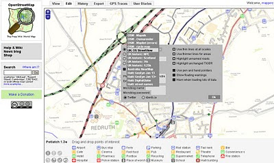
switching to 1:10,000 UK:Streetview Raster Background in Open Street Map Editor

Before you go to far please read this
http://wiki.openstreetmap.org/wiki/Ordnance_Survey_Opendata

take note of:

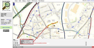
When tracing over OS StreetView

  • When everything is derived from OS StreetView source=OS_OpenData_StreetView
  • When just the name is derived from OS StreetView source:name=OS_OpenData_StreetView

When adding OS vector data

Choose an appropriate tag for the object based upon the OS OpenData product. For example source=OS_OpenData_Boundary-Line

OS OpenData StreetView OSM editor Potlatch
OSM edits with OS StreetView 10k Rasters - adding a Residential Road.

OS OpenData StreetView OSM Potlatch Redruth
http://www.openstreetmap.org/?lat=50.23952&lon=-5.22222&zoom=15&layers=B000FTF

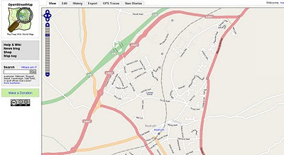
Redruth, Cornwall has always been a bit thin on the ground with OSM data but the Ordnance Survey Open Data Rasters (re-projected)to WGS84 can now help as a background to trace. If tracing from OS Rasters please use the tag source=OS_OpenData_StreetView (if both Name and Road have be derived from OS opendata)
if just the name source:name=OS_OpenData_StreetView

source & thanks to: http://twitter.com/richardf/statuses/11754544110
OS StreetView is now in #osm potlatch editor at zoom levels 15/16 - just click the options icon and select 'OS StreetView'

Labels: , , , , ,

05 April 2010

OSM compare with OS Opendata Meridian2

OSM compare with OS Opendata Meridian2

update3:

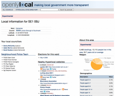
Also Openlylocal is using the OS Opendata Postcodes
Openlylocal.com

http://countculture.wordpress.com/2010/04/06/new-feature-search-for-information-by-postcode/

update2 : Geocode Great Britain Postcodes >> http://www.uk-postcodes.com/ (not Northern Ireland) in HTML, XML, CSV, JSON or RDF formats. [now improved]

update at bottom: OS Streetview(10k rasters) with OSM in WGS84 (latitude, longitude like google,bing multimap maps)

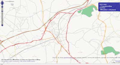
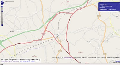
View OpenStreetMap tiles and the new Ordnance Survey OpenData Meridian 2 tiles.
(but go with Meridian2 now or wait for VectorMap District next month?)

OSM compare with OS Opendata Meridian2
Redruth could be improved with the import of Meridian2 data - but is it worth waiting for the New OS Dataset 'VectorMap District' due in May 2010?

Meridian 2 Scale
"
The product is typically viewed at 1:50,000 and at this scale the generalisation of its features maintain geometric integrity and accuracy."


OSM compare with OpenData Meridian2

Traditional Open Street Map tiles can Meridian 2 help improve the more rural areas with many missing roads?

Compare the maps yourself woth the slider in the top left corner.
http://gibin.geog.ucl.ac.uk/~ollie/osopendata/meridian/?zoom=14&lat=50.23598&lon=-5.2233&layers=BT

[Very helpful and quickly set up]


May2010 - sample data is now available for
Bath (SP76) & Milton Keynes (SP83)
VectorMap District format and scale
Raster (lzw tiff)
Nominal scale is 1:25 000.

Recommended scale range is 1:20 000 to 1:30 000.

Vector (ESRI Shapefile)
Nominal scale is 1:25 000.
Recommended scale range is 1:15 000 to 1:30 000.


"
Coming soon – mid-scale customisable mapping

May 2010 will see the launch of OS VectorMap District, a customisable map that you can style to meet your own specific needs. What's more it will be available to use as part of the OS OpenData initiative!

OS VectorMap District provides a backdrop against which other datasets, together with your own information, can be overlaid. OS VectorMap District provides a great combination of high-quality data with the freedom to show the content you want, in the way you want to show it.

OS VectorMap District will be available in both raster and vector formats, so you can use it “out of the box”, or customise the look and feel to meet your specific needs. The vector format is supplied as points, lines, polygons and text, and includes 35 different types of feature code. This allows you to select and style different features in different ways."

More details

http://oliverobrien.co.uk/2010/04/accuracy-vs-completeness-osm-vs-meridian/

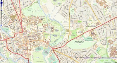
Ordnance Survey Streetview (Rasters) with Open Street Map

Ordnance Survey Streetview (Rasters) with Open Street Map (Development)

http://edgemaster.dev.openstreetmap.org/streetview_tiles/ossv.html?zoom=15&lat=51.75539&lon=-1.2401&layers=BTF


Labels: , , , , , ,

02 April 2010

Surrey Embraces the Open Data Initiative

Surrey Embraces the Open Data Initiative
(Open Street Map gets High Resolution Aerial Photography)

osm_mapper ITO World

Surrey Heath Borough Council and ITO World are proud to announce the first release of high resolution aerial photography, for all of Surrey, UK, to OpenStreetMap under an open licence that allows reuse.

The idea came to James Rutter, GIS Manager for Surrey Heath,
“we created most of the OpenStreetMap data for Surrey Heath, and it struck me that if we had high resolution aerial imagery then many more people would contribute.”

The project also has the financial backing of nine other Surrey districts: Epsom and Ewell,Elmbridge, Guilford, Mole Valley, Runnymede, Spelthorne, Tandridge and Woking. All of
whom will benefit from processed aerial imagery tiles that can be used internally, and the imagery will also be available to OpenStreetMap users so they can contribute to a better
map of Surrey.

There are multiple benefits to be gained by Local Authorities working with OpenStreetMap,
such as a more democratically made map with instant updates. James Rutter said, “we
wanted to start mapping details that were relevant to our local communities, not just what data providers feel is worth mapping. We can edit OpenStreetMap and see the updates
almost instantly, the Ordnance Survey raster products take months for new releases. By doing this we are also making a high quality map base available for all communities in Surrey, with data that we have checked for accuracy.”

ITO World are providing services to allow authorities to monitor and review the accuracy of
contributions to OpenStreetMap for their local area. Christopher Osborne of ITO, says
“OSM Mapper has thousands of users globally, and a growing number of Local Authorities
are using it to engage with the OpenStreetMap project. We provide OpenStreetMap tiles
for websites, but now we are being asked how to crowdsource improvements to data, such as changes to roads and bus stops.” OSM Mapper is a free online product, developed with the support of Ideas In Transit, a five year research project funded by the UK Government.

High quality aerial imagery has been proven to be an extremely effective resource when creating detailed mapping. After the Haiti earthquake, satellite photography was released under an open licence by GeoEye and DigitalGlobe, which resulted in a detailed map of Haiti within days. ITO World visualised the story of ʻOpenStreetMap: Project Haitiʼ, for Sir Tim Berners-Leeʼs talk at this yearʼs TED conference. The visualisation provides a vivid story of how thousands of volunteers from the OSM community were able to create the most comprehensive map of Haiti, using the imagery.

Peter Miller of ITO World, says “the Government's commitment to opening up official data and the imminent release of various Ordnance Survey datasets, under an open license is a very significant development. We are confident this will to lead to considerable innovation to the benefit of the UK economy and its citizens.”


Links:
http://twitter.com/osbornec
ITO World - http://www.itoworld.com
MySurreyHeath - http://isharemaps.surreyheath.gov.uk/mySurreyHeath.aspx
OSM Mapper - http://www.itoworld.com/static/openstreetmap.html

Labels: , , , ,

15 March 2010

CycleStreets.net Easy Cycle Routes Maps

CycleStreets.net Easy Cycle Routes Maps

Some really nice implementations making cycle route planning much easier and user friendly.
CycleStreets.net Namefinder Geocoder

As well as adding postcode search support recently, CycleStreets.net this week upgraded the general street/place finding system geocoder. Default map is Open Street Map (Cycle Map) but Google Streets and Google Satellite are available via the map controls. Image source: http://www.cyclestreets.net/blog/2010/03/14/geocoder-upgraded/

Some tips for quicker searches are:

  • If the map is zoomed out, ideally include a city name as well, so that it knows what area to look in
  • If you do specify a city, add a comma before it, e.g. “York Street, Cambridge” rather than just “York Street Cambridge”
  • Note that lower-case text works the same as Capitalised Text.
f you decide to follow the suggested journey below please take extra care on unfamiliar sections - proceed at your own risk as route quality cannot be guaranteed.

Journey can be customised into 3 types of cycling
  1. Fastest route
  2. Balanced route
  3. Quietest route

CycleStreets.net Route with Photo

Gradient, Wiggliness and number of Traffic lights are also factored in for your journey on your bike.

Example:
Quietness: 83 % Quiet (shhh at the back!)
Traffic signals:at junctions
Wiggliness: 0%. (like it)
Specific Leaving 11.09am, Arriving Times 11.29am.

CycleStreets.net Route with UK Streetview
Now the UK has Full Google Streeview coverage it can be added to almost any cycle route you now plan.

Plan your route on bike, tandem, trike by using this mapping site:

http://www.cyclestreets.net/

Very good work
For more information and details on the technological (gecoder) aspects visit
http://www.cyclestreets.net/blog/

Please Note:
CycleStreets beta: Not all areas have complete cycle route data yet. CycleStreets is UK-wide with over 1500+ locations http://www.cyclestreets.net/area/

Labels: , , , , , , ,

04 September 2009

TopOSM Updates

TopOSM Updates

The 'prettiest' form of Open Street Map has a nice clean update:

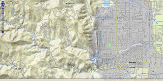
TopOSM Colorado
TopOSM has new coverage - Colorado

Permalink - http://toposm.com/co/?zoom=14&lat=40.0303&lon=-105.30387&layers=B0TT

(Links to the map above)

TopOSM Changes:
  • Released TopOSM Colorado
  • Colour-by-elevation in base layer
  • The hillshading, contour lines and map features are on separate layers. Use the layer switcher (top right "+") to toggle.
Techie talk:
"I created a Python script to generate map legend HTML snippets - complete with images - from mapnik description files and a short description file that specify what features to include. You can see the result at http://toposm.com/ma clicking on the "Show/Hide Legend" at the bottom right. Legends are specific to the current zoom level, so they will refresh when zooming in and out."

"I also added elevation labels for contour lines. The only issue is that the data from MassGIS (where the contours come from) is in meters (3 meter interval) and my map is entirely in ft, so the values look a bit funky sometimes. Not much I can do about that, though..."
Lars Ahlzen

Lots of minor other improvements too. There's a full change log at:
http://toposm.com/changelog.html

As always, the map is at http://toposm.com/

Full Credit to Lars Ahlzen in this excellent version of Open Street Map
he notes:
"It took longer than I thought, but I've finally released TopOSM (my OSM-based topographic map project) for the state of Colorado."


Source:
http://www.openstreetmap.org/user/Ahlzen/diary

Previous Posts:
http://mapperz.blogspot.com/2009/04/toposm-pretty-openstreet-map.html

Labels: , , , , , ,

17 August 2009

Easy OpenStreetMap Editors

Easy OpenStreetMap Editors


One early frustration with wanting to help the OpenStreetMap project was how do you edit the data easily?

OpenStreetMap has lot and lots of data already, though more and more people are required for their local knowledge and to do the mamouth task of keeping the 'map up-to-date'

Well there are lots of different applications from online editors to compiled source code are out there. Which is easiest and user friendly?

These two are mapperz best picks

Merkataartor (v0.14) - fairy new software - but nicely laid out user friendly. Has great potential and is supported by most OS
see the list
http://wiki.openstreetmap.org/index.php/Merkaartor#Download
http://www.merkaartor.org/Download/

Small download, very simple to use - download by area/map of your choice.
No knowledge of OSM to start using. (But advise you to research first)
uploading does require a osm account so you can contribute but downloading and viewing data (in cartographic map-form) does not require a login.
Merkaator Yahoo Imagery - London Bridge

Software is updated regularly and many features have been added - recently Area digitising and tagging tools have been introduced.
Offline mode.
Map Style mode - set one from the list or make your own.
Documentaton: http://wiki.openstreetmap.org/index.php/Merkaartor_doc_0.12
(requires an update to v0.14)


Potlatch - long standing Open Street Map 'online editor' but now more user friendly than ever (thankfully).
Back along mapperz liked the idea of editing in a browser (as all GIS will be in the future).
But Potlatch back then was slow,buggy and choked the browser up - all those issues are long gone and now it is a really fast and easy way to edit 'live'.

Potlatch POI drag and drop editing
Potlatch has greatly increased productivity due to the 'drag and drop' POI (Points of Interest) tool. Tip you reuse tag names with the 'r' button (repeat tag) remember to give as much infomation as you know.
Note: There are many tag names (too many to list) please visit
http://wiki.openstreetmap.org/wiki/Map_Features
for a full list of tags.

Yes, there are many, many other OSM editors out there but this is for the curious potential new user, that just wants to help out.

others:
JOSM is currently the most popular desktop editor. It is a standalone Java application (requires Java 1.5) which allows fluid zooming, panning, and editing of a locally stored dataset, before uploading changes in a batch.

OSM2Go is a mobile mapping solution currently supporting the Nokia Internet Tablet family (N800 & N810), can also be compiled for the Linux/GTK+ desktop.

Vespucci [1] for android devices.

Amenity Editor is a simple online editor for creating and editing nodes and POIs. (ATM only in German)
source:
http://wiki.openstreetmap.org/wiki/Editing

Labels: , , , , , , ,

17 July 2009

Open Street Map - Static API (Development)

Open Street Map - Static API (Early Development)

"Main idea of the project is to create an web application which will provide an easy way of embedding maps into web pages. Application is going to be deeply configurable and easy to install by anyone on his server. It is being implemented in PHP5.

Mapperz first static osm map:

This an Open Street Map generated image live from the osm development server
The url that created this image is
http://dev.openstreetmap.org/~pafciu17/?module=map&center=-1.877589,50.7224&zoom=14&width=400&height=400type=cycle

Required parameters:

&center=latitude,longitude
&zoom=14 (can be 1 to 18)
&width=400 (400px)
&height=400 (400px)
type=cycle (can be mapnik, osmrender or cycle)

optional &imgType=gif or jpg (png is default)

Paths can be created (Google Maps API static maps lacks this function currently)


http://dev.openstreetmap.org/~pafciu17/?module=map&bbox=-100,45,-67,5&width=400&paths=-74,40.34,-82.3,23.1,-85,35,-87.2,32.12;-90,40,-80,40

(green is the first zigzag lines then after the semi-colon ; is the second line)


Suggestions and reporting errors:
During first month of work scaffold of application has been created with its basic functionality. Now it is time for improvements and adding new features. I would be very grateful for any feedback about API. You can send comments, information about errors etc. to osm.static.maps.api(at)gmail.com."

Mapperz has a couple of suggestions:
Can annotation be added? Like "you are here" anno=you%20are%20here;-90,180
Can polygons be added? poly=-90,180;-80,180;-80,90;-90,180&fillcolour=R255G123B0
icons - icon=basic1&3 (a circle with 3 in the middle)?

Full details
http://dev.openstreetmap.org/~pafciu17/


Your area missing map data?
Then contribute to the Open Street Map database - you be surprised how easy it is to add your own collected data. You might even get hooked like with 125,000 other osm contributors.
http://wiki.openstreetmap.org/wiki/Main_Page

Looks very promising.

Labels: , , , , , ,