->

17 July 2009

Open Street Map - Static API (Development)

Open Street Map - Static API (Early Development)

"Main idea of the project is to create an web application which will provide an easy way of embedding maps into web pages. Application is going to be deeply configurable and easy to install by anyone on his server. It is being implemented in PHP5.

Mapperz first static osm map:

This an Open Street Map generated image live from the osm development server
The url that created this image is
http://dev.openstreetmap.org/~pafciu17/?module=map&center=-1.877589,50.7224&zoom=14&width=400&height=400type=cycle

Required parameters:

&center=latitude,longitude
&zoom=14 (can be 1 to 18)
&width=400 (400px)
&height=400 (400px)
type=cycle (can be mapnik, osmrender or cycle)

optional &imgType=gif or jpg (png is default)

Paths can be created (Google Maps API static maps lacks this function currently)


http://dev.openstreetmap.org/~pafciu17/?module=map&bbox=-100,45,-67,5&width=400&paths=-74,40.34,-82.3,23.1,-85,35,-87.2,32.12;-90,40,-80,40

(green is the first zigzag lines then after the semi-colon ; is the second line)


Suggestions and reporting errors:
During first month of work scaffold of application has been created with its basic functionality. Now it is time for improvements and adding new features. I would be very grateful for any feedback about API. You can send comments, information about errors etc. to osm.static.maps.api(at)gmail.com."

Mapperz has a couple of suggestions:
Can annotation be added? Like "you are here" anno=you%20are%20here;-90,180
Can polygons be added? poly=-90,180;-80,180;-80,90;-90,180&fillcolour=R255G123B0
icons - icon=basic1&3 (a circle with 3 in the middle)?

Full details
http://dev.openstreetmap.org/~pafciu17/


Your area missing map data?
Then contribute to the Open Street Map database - you be surprised how easy it is to add your own collected data. You might even get hooked like with 125,000 other osm contributors.
http://wiki.openstreetmap.org/wiki/Main_Page

Looks very promising.

Labels: , , , , , ,

25 May 2009

Google Maps Now Suggests Alternative Routes

Google Maps Now Suggests Alternative Routes

Google Maps Now Suggests Alternative Routes
Google Maps now in certain routes automatically creates an
alternative route.

This can be helpful for users wanting more choice when using the
driving directions from Google.
The 'suggested' option is currently available in Google Maps only
and not the Google Maps API.

The map above route with suggested routes is available with this link:

Dragging the routes is still available after a suggested route is selected.

Labels: , , , ,

03 March 2009

CloudMade Map Editor

CloudMade Map Editor

update 05/03/2009
CloudMade feedback (see comments) looks promising. Thanks for the kind remarks, always willing to help a brilliant minded concept.

Ever wished you can create your own style of map online?
Well CloudMade Map Style Editor might be what you have been waiting for.

"Tired of the same old maps? CloudMade's Style Editor lets you create customized cartography that you can use to distinguish your applications. With the Style Editor, you can easily create a unique map style in a matter of minutes without having to install any special software or have any previous cartography experience"
source:Cloudmade

It uses data from Open Street Map, then allows a logged in user to edit the colour of Roads, Points of Interest [POI], Area features.
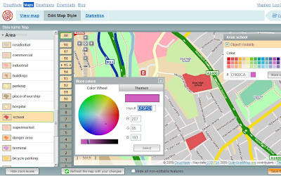
Cloudmade Editor School colour picker
Selecting and editing colours is made easy using this CloudMade Map Style editor.

But what happens if you want different representations of a feature at different scales?
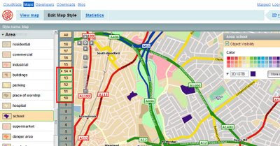
Cloudmade Editor School colour picker - Zoom Levels
Note the zoom scales selected, at these scale you will see a strong purple representation, zoom in and it will be transformed into a more subtle colour (this is only for demonstrating this technique).

Mapperz wish list: (now this is just a very short version)
  • Edit Fonts (Annotation) but notoriously difficult to implement
  • Text Placement, Centre, North,South,East,West placement of point/symbols with text.
  • CMYK colour picker option (for printer), RGB and Hexidemical colours only useful for Screen/Web. See ColorBrewer for this type of usefulness.
  • Polygon to Point Representation [e.g.When a School is at an unsuitable scale for area representation is can be displayed by a point/symbol instead)
  • Preview/Outline Mode (with Auto Refresh) - currently the user requires to click 'refresh the map with your changes' button. Outline mode for seeing the nodes and segments. Similar function is in Adobe Illustrator.
  • Reorder Layers, ranking structure - sometimes having polygons above features can be useful, like a masking out polygon.
  • Export File like Illustrator. (maintaining styles and line widths with attributes).
  • Grid or Graticule Option.
  • Fix the Help [http://www.cloudmade.com/site/products%2Fstyle-editor%2Fhowto] The requested URL /site/products/style-editor/howto was not found on this server.
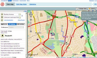
CloudMade Custom Map Directions
And finally you can already add routing/directions to you customised map, this is because the underlining data has not been changed. Only the graphical representation of the data has been customised.

This is just one of many products CloudMade is offering - here is a full list of all.
http://cloudmade.com/products


Some have already created their own map styles, this are available to view
http://cloudmade.com/products/style-editor/gallery


Below is Mapperz first attempt at showing the schools changing colours when zooming in.


Labels: , , , , , ,

26 January 2009

Filmaps.com - Film Locations - Mapped

Filmaps - Film Locations - Mapped

update 27/09/2009
Google Maps Mania Expands the Film Exposure on Maps
http://googlemapsmania.blogspot.com/2009/01/film-locations-on-google-maps.html

Clean cut, easy to navigate, film suggester and maps what else is there...

Film Maps - Bourne Ultimatum
If you know a film well then you can add your own locations and using the 'I know a location' button

"We like films (movies and TV series) and we love travelling around the world, who doesn't?...Sometimes the charm of the places where the films have been filmed wakes up your adventure soul and you would like to discover even visit the exactly place where the scene took place. That's the filmaps aim, the possibility of locating that place!"

There is a lot of activities and tours related with film locations which are designed in order to visit some of them and
recreate the film action. Filmaps wants to help people in order to find that place.

A nice mashup with huge potential to link up with imdb, wiki or rotten tomatoes databases
example 'The Bourne Ultimatum'
http://www.imdb.com/title/tt0440963/
http://en.wikipedia.org/wiki/The_Bourne_Ultimatum_(film)
http://uk.rottentomatoes.com/m/bourne_ultimatum/

Then it's a question of keeping it up to date.

Labels: , , , , ,

15 February 2008

OpenSpace API - More Examples Please

OpenSpace API - More Examples Please

15/02/2008

Keep them coming... (and keep asking the OS for 1:25,000 Explorer Mapping!)


http://www.geothings.net/openspace/index.html

blog post
openspace-licences-limits-and-first-steps-plus-demo

OpenSpace API - More Examples Please

A few weeks on from the Ordnance Survey releasing the OpenSpace API there are a few that are taking up the small challenge and using the API to full effect.

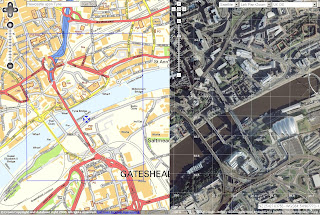
OpenSpace API & Google Maps API Combo Map
Very Clever

http://wheresthepath.googlepages.com/wheresthepath.htm

Note: Spilt screen half OS OpenSpace API and half Google Maps API Aerial imagery and is linked by location (pan and zooom can be enabled)
Blue transparent box shows the extent - switches between the maps.

Another Great Example

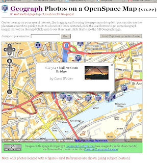
Geograph Photo Locator Map
Geograph Photos on a OpenSpace Map (v0.2c)
http://openspace.nearby.org.uk/geograph.php
(Please do not use the page to plot locations for Geograph!)

Suggestions to make a better Mapping API - OS 1:25k would complete the set as there is a big jump between 1:50k mapping and 1:10k Streetview mapping.

Note: 1:25k is available on the Get a map service. Then you would be able to plan walking and hiking trips using the OpenSpace API. (1:25k has all public footpaths)
Not asking for 1:10k Rasters or MasterMap but there needs a scale.
There needs to be more Official Examples and better documentation with clear examples.

http://openspace.ordnancesurvey.co.uk/openspace/support.html
maybe and Advanced Section showing users the full potential of what can be done.

Working pages rather than static images with code would also be a helpful guide to newcomers to mapping API's.

Know of another OpenSpace API Map or have another suggestion? Then add yours via the comments.

Note:
"Newcastle-upon-Tyne" needs to be "Newcastle upon Tyne" or you will get an error.

Note:
"There will be a outage today 14th Feburary OpenSpace has a planned downtime from 5-6PM GMT today."

Labels: , , , ,