->

20 April 2011

Ovi Maps 3D Beta (Now Photorealistic)

Ovi Maps 3D Beta ( Now Photo-realistic)


Cities coverage

Nokia's photorealistic 3D models of metropolitan areas initially include:

- Barcelona
- Boston
- Chicago
- London
- Copenhagen
- Florence
- Helsinki
- Las Vegas
- Los Angeles
- Madrid
- Miami
- Milan
- New York
- Oslo
- Prague
- San Francisco
- Stockholm
- Toronto
- Venice
- Vienna

http://maps.ovi.com/3d/
(plugin required) - servers are in demand currently and might not get the full picture - wait a few days for the hype to calm down.

http://conversations.nokia.com/2011/04/19/ovi-maps-3d-the-world-is-not-flat/

Labels: , , , , ,

11 April 2011

New Zealand 1:50,000 Topo Maps

New Zealand Topo Map

New Zealand Topo Map is an interactive topographic map of New Zealand using the official LINZ's 1:50,000 / Topo50 and 1:250,000 / Topo250 maps.http://www.blogger.com/img/blank.gif

New Zealand 1:50,000 Topo Maps

http://www.topomap.co.nz/NZTopoMap/9432/Vampire/Westland

Lord of the Rings (and The Hobbit 2012) Fans will be interested in
http://www.topomap.co.nz/NZTopoMap/7770/Lindis%20Pass/Otago

Labels: , , , ,

24 February 2011

Embed ArcGIS Online Maps for Free

Embed ArcGIS Online Maps for Free


View Larger Map

required > OpenStreetMap and the license (CC-by-SA). < http://wiki.openstreetmap.org/wiki/OpenStreetMap_License#Attribution">OSM attribution).

A fix is required on the ESRI side [code]

Thanks to David highlighting the issue.
http://lists.openstreetmap.org/pipermail/talk/2011-February/056894.html

Full Screen Map
http://www.arcgis.com/home/webmap/embedViewer.html?webmap=1907d8d1c2954484b4b6569b5d8de305&zoom=true&scale=true


ArcGIS Online Example & Make your Own Map(s)
http://www.arcgis.com/home/
source:
http://nygeog.blogspot.com/2011/02/embedding-arcgis-online-maps-open.html
deleted by poster.

Labels: , , , ,

24 December 2010

Pegmans Gets A Hat

Pegmans Gets A Hat

Pegman finds a Hat
Pegman gets a Christmas hat for the weekend? http://goo.gl/maps/jAgL

Predictions - 2011 will bring,

A new perspective to old fashioned raster maps... with the help of HTML5.

OpenStreetMap will go mainstream... more so than at present.

AddressPoint (UK Postal Address locations) become more accessible without huge costs.

Fusion Tables SPATIAL will improve vastly.

Best of 2010 mapping
Opendata from Ordnance Survey. (No April Fools there)

Ovi Maps downloads maps via wifi to phone (no more Ovi Suite!)

Bing Maps Apps more usable adding OpenStreetMap.

MapQuest pump $1million in Open Source Data.

Labels: , , , ,

09 November 2010

Artography Maps

Artography Maps

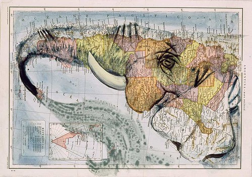
More art into cartography and creating amazing illustrations...

Artography - Dolphin Map

"The word atlas conjures up two very different ways of perceiving the world. The first one that springs to mind is of a book containing a planet-spanning collection of maps, exhaustively descriptive. And then there's Atlas the Greek titan, condemned to carry the weight of the entire world (1) on his shoulders. The latter meaning begot the former: when cartographers started publishing map collections in book-form, they often included in the frontispiece of those collections an image of the world-bearer"


Artography - Elephant Map

Full coverage [Source] including more Artography on The Big Think Blog

Labels: , , , ,

22 October 2010

Take a Walk - Clover Campaign

Take a Walk - Clover Campaign

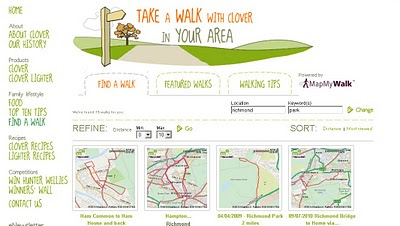
With over 25,000 walking routes throughout the UK. Short to long walks are available ranging from 0.1 to 30 miles.


Take A Walk Clover Maps
After entering your rough walk preferred location and the distance you are wanting to walk.
Some preset maps are also available.

Take A Walk Clover Maps
You chosen route is overlaid on a Google map and mileage markers are represented.
Routes can be printed or emailed/tweeted for later use or sharing.

Clover is behind the campaign with the routes provided by http://www.mapmywalk.com/

Find a Route with Clover
http://www.cloverfamily.co.uk/find-a-walk/

Labels: , , , , ,

01 September 2010

New BBC Travel Maps (Beta)

New BBC Travel Maps (Beta)

New BBC Travel Maps (Beta)
Improved Navigation and live feeds (jamcams included), much better Travel News from the BBC.

http://www.bbc.co.uk/travelbeta/birmingham/

What's new:
  • Updated design, with wider pages and larger text.
  • Improved navigation, allowing movement between adjacent geographic areas
  • Interactive mapping, which can be minimised if you prefer the text incident list
  • Clearer timestamping of incidents.
  • Traffic jam cams showing frequently updated still images of traffic conditions on motorways and trunk roads
Addional Improvements
  • The text incident list has been updated to improve readability, and is synchronised with the map.
  • Local weather forecast from the BBC Weather Centre for the next 6 hours from now
  • Backend improvements to our data-handling system to categorise data, and speed up the reception and delivery of data to the site.

What's not changed:
  • BBC's comprehensive traffic and travel information remains at the core of the service, updated around the clock
  • The text list remains, and you can hide/minimise the map, to put the functionality of the site back to the way it used to be.
  • BBC have made the redesign as subtle as possible, in order to retain the things you've told us you like about the existing site.
  • In the final version of the site, you'll be able to click to see a country-wide motorways or major roads overview from every page.
  • BBC's door-to-door journey planner, powered by Transport Direct, remains but has been made more prominent.

Why a new version of BBC Travel News:

"Firstly, to update the design to take advantage of the BBC's wider page layout, introduce maps across the site for the first time, and make some basic improvements to the presentation of our information
Secondly, to improve the data-handling processes behind the scenes, to allow us to separate the data into more useful groups, and reduce the time it takes for the data to reach you
Thirdly, to integrate traffic jam cameras (where available) into the main BBC Travel News website alongside our incident data"

Current BBC Travel Maps (Beta) Areas:

Birmingham beta
Black Country beta
Coventry beta
Herefordshire beta
Shropshire beta
Staffordshire beta
Warwickshire beta
West Midlands beta
Worcestershire beta
Wolverhampton beta

Labels: , , , ,

30 August 2010

Embed MapQuest - New

Embed MapQuest - New
You can now add MapQuest maps to your blog or website.


How to do this:
Enter the location into New.MapQuest.com
Click the “Send To” button, then the “Your Website” tab
Copy and paste the code to your site.

"The MapQuest specific HTML code is written for you and all you need to do is add that text to your HTML source on your web page. This is useful for businesses, bloggers, or even hobbyists building your own website. Imagine making it easier for your customers to see where you are, and with a click or two, they can get directions directly to your location. This allows you to add maps instead of just links! This works for single locations, as well as routes. More advanced features for Embedded maps will be coming soon as we continue our fast, iterative feature releases."

Also includes the ability to pick your language, search and re-arrange saved locations within your ‘My Maps’ collections and more in-line help. We have also updated the ‘Send to’ feature to now support Garmin GPS devices and added the Embedded Maps option.


Source:

Labels: , , , ,

27 August 2010

Hurricane Tracker Bing Maps

Hurricane Tracker Bing Maps
*Hurricane Danielle is now a category 4 (major hurricane)

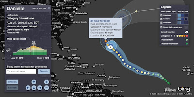
See current locations, forecast paths and detailed stats for any active hurricane this season (2010)

Hurricane Tracker Bing Maps
Currently Hurricane Danielle 2010 - Currently Category 4

  • Profile view of wind speed & forecast wind
  • Animated symbols
  • Lighten darken map
  • Possible forecast error shown
View the Hurricane Bing Map
http://www.msnbc.msn.com/id/26295161/

source:
http://bingmapswatch.blogspot.com/2010/08/hurricane-tracker-bing-maps.html


Another very good and interactive map to track Hurricanes is Stormpulse.

Hurricane Danielle Stormpulse Map

http://www.stormpulse.com/

Labels: , , , , ,

26 August 2010

Map Channels - Location Maps

Map Channels - Location Maps
*Using Google Maps API v3

Location Maps are simple controls to display a map of a single location. Street View can optionally be shown with the map.

Location Maps use the
Google Maps v3 API and are provided free for commercial or non-commercial use.

No adverts are included in Location Maps. An 'embed' control links from the map to this page.


Control size, maptype, map controls, markers and more with the new Location Maps which utilizes the fast v3 of Google Maps API.

Technical Notes:

You may copy the embeddable Location Map HTML Page to your own website (change the url used within the embeddable HTML code).

• Location Maps use the new Google Maps v3 API. This is more compact so loads faster.
• No API Key is needed for the Google Maps v3 API.
• The Street View is displayed without using Flash so no browser plugins are required.
• The 'fullscreen view' option included with the v2 API is not available. To see a larger street view click on the Google logo to see the street view at maps.google.com.

Full API reference can be found here http://www.mapchannels.com/LocationMaps.aspx#api


Labels: , , , , , ,

20 July 2010

StepMap - Create Free World Maps

StepMap - Create Free Personal World Maps

"StepMap is a free service, enabling you to create, edit and share individual and personalized maps. Also, it allows you to export your maps to any other web site. The term "map" includes all kinds of topics, themes and design option. StepMap offers you a free tool to create maps that represent your specific, personal requirements and design ideas."

Step Maps - Create Free World Maps - Step1
Create and customise your own world, regional or country map with this service.

Step Maps - Create Free World Maps - Step2
Change the style, add, symbols, images, media, text, metadata a comprehensive resource in creating very specific mapping for personal and commercial use.

Personal Commercial
Creating a Map using the Online-Editor FREE FREE
Presentation in the Map Directory FREE FREE
Save as private Map FREE FREE
Embedding the Map to another website FREE FREE
Additional web space for rich media FREE FREE
Adding to Google Search FREE FREE
Printing a Map FREE PAID


StepMap for Educational Purposes

The free of charge features that are listed for private users also apply for any educational purpose, e.g. schools, universities or research.

That means that teachers and students can use StepMap for free considering the general terms ad conditions.

http://www.stepmap.com/termsofuse2.php


Try creating your map

An example

Labels: , , , , ,

11 July 2010

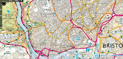
Ordnance Survey Map in Bing Maps - Silverlight

Ordnance Survey Map in Bing Maps 1:25k and 1:50k Mapping Scales

Ordnance Survey 50k Landranger Bing Maps Silverlight

Ordnance Survey 1:50,000 (Landranger series) scale mapping in Bing Maps

Ordnance Survey 25k Landranger Bing Maps Silverlight
Ordnance Survey 1:25.000 (Explorer series) scale mapping in Bing Maps

http://uslot.com/NewBingTestPage.html

Source:
http://bingmapswatch.blogspot.com/2010/07/ordnance-survey-map-in-bing-maps.html

more details on the implementation from this blog
http://jimlynn.wordpress.com/2009/11/12/ordnance-survey-maps-in-bing-maps-silverlight-control/

Labels: , , , , ,

10 May 2010

Global Action Atlas by National Geographic

Global Action Atlas by National Geographic

Global Action Atlas by National Geographic. The application allows users to peer into areas where our planet needs help. National Geographic and Bing Maps invite you to support efforts across the globe to help people in need, protect plants and animals, usands of others who are donating, volunteering, and sharing knowledge on behalf of community-based projects working to solve global challenges.

National Geographic Global Action Atlas Bing Map
"The Global Action Atlas spotlights hundreds of local, cause-related projects from around the world to a large audience of concerned citizens, giving individuals opportunities to take action by donating, volunteering, advocating, and sharing information. The Atlas enhances and extends the mission of the National Geographic Society"

Themes of interest include Conservation, Humanitarian Affairs, Cultures, Exploration, Climate Change and Energy.

Global Action Atlas

  • Conservation: Includes categories on animals and plants; fresh water; landscapes; migrations and corridors; and oceans and coastal areas.
  • Climate Change: Focuses on projects having to do with forest conservation and management; renewable energy; reforestation; and ocean impacts.
  • Cultures: Features projects focusing on preserving endangered languages; cultural preservation; archeology; and indigenous rights.
  • Energy: Focuses on technology; energy efficiency; and energy investment.
  • Exploration: Focuses on taking action to help preserve our planet; to explore its mysteries through sustainable travel; and to raise awareness about cultures and environments, and science and adventure projects.
  • Humanitarian Affairs: Includes projects focusing on water and sanitation; emergency relief; health; education; empowering women; and poverty and hunger.

View the Global Action Atlas - http://www.actionatlas.org/map

source:http://www.bing.com/community/blogs/maps/archive/2010/05/10/new-bing-maps-application-global-action-atlas.aspx

Labels: , , ,

25 March 2010

@Nomads_land got Ordnance Survey Maps!

@Nomads_land got Ordnance Survey Maps!

What's the story here?

Ordnance Survey have helped the request for Ordnance Survey maps for a long walk (7,000 miles) around the United Kingdom for 3 UK Charities by Nathaniel Severs
Ordnance Survey
http://www.ordnancesurvey.co.uk/oswebsite/

The Three Charities:
  1. Southampton General Hospitals Paediatric Physiotherapy department
  2. The Stroke Association
  3. The Mammal Society
The request:
requested: 10:33 AM Mar 16th via Twitter on the web
S: Right Twitter,Nat is after some maps for the Scottish leg of the walk. SO, has anyone got OS Maps of scotland they could donate?Please RT

@mapperz picked up this request after following the daily tweets from @Nomads_land on his walk around the UK coast.

Basically mapperz has a number of good contacts, those contact have even better contacts.
Enter @StevenFeldman to the request and things really start moving and thanks to him Ordnance Survey have given the maps away for the Scottish leg of the 7,000 mile journey. That's over 40 1:25,000 Explorer Maps and a geo success of social networking that can be achieved.

More info on the guy doing the work:
"My names is Nathaniel Severs, I am 24 years old and in 2010, I am walking the entire coastline of mainland Britain (7,000 miles) for three great charities."Nomad's Land Big Walk Blog
Keep up to date on the Big Walk on http://natsevs.wordpress.com/

"I set out from Portsmouth on 10 January accompanied only by a large rucksack carrying my tent and kit. I camp most nights but am open to offers for accomodation! The entire journey will be completed using leg power and if there is a bridge, I will be crossing it (so Anglesey and the Isle of Skye will both be on the agenda). I will stay true to the coastline at all times, so if there is a ferry across a river (the River Dart, for example) that is not classed as coastline, then I will allow myself to take a ferry if one is available. But a ferry cannot be used at any other time. I aim to be home by Christmas!"

The journey so far
Nats Big Walk Route
Natathan is currently along Pembrokeshire Coast Path [Fishguard] (a very nice walk rain or sun)
Follow his progress here http://natsevs.wordpress.com/progress/

Many thanks to:

@Nomads_land for taking up the challenge to walk around the entire UK coast
http://natsevs.wordpress.com/

Steven Feldman (@StevenFeldman)
http://giscussions.blogspot.com/

Ordnance Survey for being so quick to respond and making the solution to the request.
hopefully a post on http://magazine.ordnancesurvey.co.uk/magazine/tscontent/editorial/exploremagazine/ about this soon?

Social networking Site Twitter - http://twitter.com/ connecting us all up.

and myself Mapperz @mapperz for helping a good cause.

Labels: , , , , , , ,

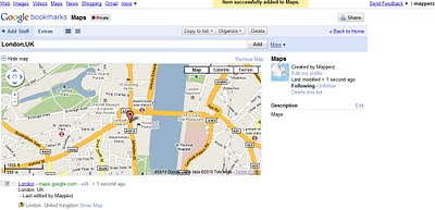
Google Bookmarks Your Maps

Google Bookmarks Your Maps

Simple, no lon
g urls can be private or public (to share)

"
Today we’re debuting lists in Google Bookmarks, an experimental new feature that helps you easily share those sites with friends."

Google Bookmarks Share Maps
Google bookmarking your maps - Tip: With the Google Toolbar simply click the star and it will be saved in your favourite bookmarks. No need to worry about very long urls that can be broken in emails etc.

https://www.google.com/bookmarks/l (Google Account Required)

Privacy
http://www.google.com/support/bookmarks/bin/answer.py?hl=en&answer=159231

Using Maps with Google Bookmarks
http://www.google.com/support/bookmarks/bin/answer.py?hl=en&answer=162168

source:
http://googleblog.blogspot.com/2010/03/collaborative-bookmarking-with-lists.html

Labels: , , , ,

17 March 2010

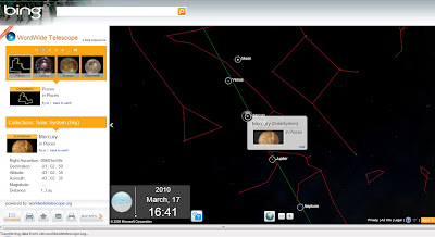
Worldwide Telescope (WWT) now in Bing Maps

Worldwide Telescope (WWT) now in Bing Maps [Preview mode]

The Sky at night (and day) in Bing Maps Explore

With the new Bing Maps Worldwide Telescope (WWT) App you can explore the constellations and other known space objects just like you would navigate through a regular Bing Maps.Worldwide Telescope Preview in Bing Maps
To access this use the "Map Apps" and choose Worldwide Telescope

Drag Telescope Icon Preview in Bing Maps
Drag the Telescope image to a location on the map you want to view (this sets the view up as "looking up" from that point from the Earth)

Worldwide Planets and charts
Exploring Planets is made easy from the data catalogue on the left hand side in the legend panel and click the very small "fly to" links. Zooming is very fast but not quite light speed.

View the Sky in Bing Maps
http://www.bing.com/maps/explore
Select >Maps Apps >Worldwide Telescope

For much more details and vast about of pulling tons of collections from the Worldwide Telescope Community including Constellations, Solar System, All-Sky Surveys, Spitzer Studies, Chandra Studies, Hubble Studies, Astrophotography, Radio Studies, NOAO Studies, Gemini Studies, Messier Catalog, Planets/Moons, Earth (Bing!), Panoramas, and Tours.
Then go to:
http://www.bing.com/community/blogs/maps/archive/2010/03/10/new-bing-maps-application-worldwide-telescope.aspx

Labels: , , , , , , , , ,

29 January 2010

Mobile GeoRSS Maps *Beta* (Map Channels)

Mobile GeoRSS Maps *Beta* (by Map Channels)

"The easy way to add mapping for mobile websites"

Mobile GeoRSS Maps combines the Google Maps v3 API and Google Feeds API to display a GeoRSS feed on a map that is optimized for mobile phone display.
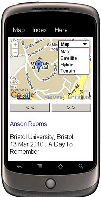
Mobile GeoRSS Maps
Create your own Map with feeds for your mobile, mymaps or georss feeds can auto-update and provide you with latest information whilst on the move.

Use Mobile GeoRSS Maps to simply add your map to your mobile website, or to generate a map link for emailing.

Google My Maps are supported. Use Mobile GeoRSS Maps to generate a mobile version of a My Map in seconds.

Mobile GeoRSS maps works on any phone which supports the Maps v3 API, such as the iPhone and Android or Symbian platforms.
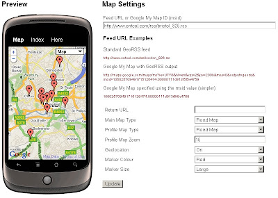
Mobile GeoRSS Maps Preview
Simple instructions to set you up for adding your own feeds to your mobile.

Technical Notes:

This map is a *beta* project, please contact us if you notice any bugs.

Only placemarks in a feed are displayed (lines and polygons are not displayed)

A maximum of 200 placemarks are displayed on the map

Custom Marker styles contained in a My Map are not displayed

base url for the following parameters
http://data.mapchannels.com/mobmap/100/map.htm

f = Feed URL or My Maps ID
r = Return URL
mt = Main Map Type (1=Road Map, 2=Satellite, 3=Hybrid, 4=Terrain)
pt =Profile Map Type (1=Road Map, 2=Satellite, 3=Hybrid, 4=Terrain)
z =Profile Map Zoom (between 1 and 20)
g =Geolocation (0=Off 1=On)
c =Marker Colour (0=Red 1=Blue 2=Green 3=White)

example:
http://data.mapchannels.com/mobmap/100/map.htm?g=1&mt=1&pt=1&z=16&c=0&s=1&f=http://www.entcal.com/rss/bristol_826.rss&r=
(will appear a full page map on a web browser)

Try it out here
http://www.mapchannels.com/MobileGeoRSSMaps.aspx

Nice, clean simple you set up and use, good work by the Map Channels keep up with developments at http://www.mapchannels.com/News.aspx

Labels: , , , , , , , ,

21 January 2010

Big News - Nokia Ovi Maps Free for Life

Big News - Nokia Ovi Maps Free for Life

updated 5.07pm 21/01/2010
Nokia Ovi Maps Free for Life
No more subscriptions, Ovi Maps with Navigation (Walking, Driving) is now Free.
*N97 soon after firmware update release.
update N97 users: "New Ovi Maps for N97 will be available on 28th January 2010." with Maps v3.3 included in the firmware update.

note:some N97 users are confirming that the new ovi maps application will install when there is more than 20mb free space on the c: drive (untested by mapperz).

A New version of Ovi Maps 3.3 comes with FREE driving (car) & walking (pedestrian) features turn-by-turn, with voice guided navigation. Ovi Maps has a large global coverage.
74 countries are covered.
Maps Data for all the regions will be available, for free, for loading over the air (data costs!) or pre-loading via a desktop computer (PC or Mac). Traffic information and city guides from the likes of Lonely Planet and Michelin, will also be made available at no additional cost.

Since Nokia owns Navteq (the map data company) they can do this without losing out. So Google, tomtom and many others look out.

Press Release:January 21, 2010
Nokia makes walk and drive navigation free on its smartphones, doubling size of mobile navigation market
http://www.nokia.com/press/press-releases/showpressrelease?newsid=1375569

Video


Official Nokia Maps Website
http://maps.nokia.com/explore-services/ovi-maps/ovi-maps-main

Supported Devices for the Nokia Ovi Maps v3.3
http://europe.nokia.com/support/product-support/maps-support/compatibility-and-download#/default/

More Details at:
http://www.womworld.com/nokia/13158/your-thoughts-on-this-mornings-ovi-maps-announcement/
http://www.allaboutsymbian.com/news/item/11010_Nokias_Ovi_Maps_navigation_goe.php

News Links
PC World
http://www.pcworld.com/article/187335/nokia_delivers_free_navigation_service_to_customers.html

Engadget
http://www.engadget.com/2010/01/21/nokia-ovi-maps-with-free-turn-by-turn-navigation-hands-on/

BBC News
http://news.bbc.co.uk/1/hi/technology/8472165.stm

The Guardian
http://www.guardian.co.uk/technology/2010/jan/21/nokia-satnav-software

The Times Online
http://technology.timesonline.co.uk/tol/news/tech_and_web/article6996954.ece

Labels: , , , , , , ,

10 January 2010

Photospots.co.uk Maps (OS & Google)

Photospots.co.uk Maps (OS & Google)

"A website for amateur photographers to share their favourite photography locations."

Photospots.co.uk Google Map
Very clean site with direction of the sun and location of the photograph clearly show for each individual shot.

UK photograph locations have the additional maps from Ordnance Survey Openspace

Photospots.co.uk OS Map
Switching from Google Maps to Ordnance Survey is extremely well implemented no page refreshing required making this very user friendly and usable.

Map and Photographs viewable
http://www.photospots.co.uk/

Blog
http://www.photospots.co.uk/blog/
Well done to Andrew Rickmann http://twitter.com/photospots/

Geograph
A similar and much more established photographic by map location project http://www.geograph.org.uk/ is hugely popular. [1,560,388 images]
"The Geograph British Isles project aims to collect geographically representative photographs and information for every square kilometre of Great Britain and Ireland"

Access to these images can be made by the Geography API.
http://www.geograph.org.uk/help/api

Here under educational licence is a slippy map version
http://www.geograph.org.uk/mapper/

See previous mapperz post on Geograph
http://mapperz.blogspot.com/2007/11/new-draggable-geograph-map-beta.html

Labels: , , , , ,

08 January 2010

Ovi Maps Racing - Sneak Peak

What happens when you combine Ovi Maps and Ovi Games? Ovi Maps Racing is what happens – another gaming title announced today by Nokia, coming soon to the Ovi Store.

Ovi Maps Racing


"In a truly unique experience, you use the GPS in your device to find your location or use Ovi Maps to choose any location in the world), then customize a track around your neighborhood, and finally fire up those engines."


useful? or just fun... you decide.

Labels: , , , , , ,