Historypin - Streetview with History
Historypin - Streetview with History
*Historypin was built with Google and they provided invaluable support throughout the process.
update: Nice introduction to HistoryPin with this video.
"Historypin is a online tool that acts as a digital time machine, allowing people to view and share history in a totally new way."

Sharing Past memories and important events with Google Streetview and Historical Photography display correctly in 4D space.
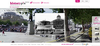
"Historypin invites the public to dig out, upload and pin their own old photos, as well as the stories behind them, onto the Historypin map. Uniquely, Historypin allows users to layer their old images onto modern Street View scenes, revealing a series of windows into the past."
http://www.wearewhatwedo.org/generations/
Interactive Timeline
One of the most useful tools for finding historical photographs is the interactive timeline that can span as far back as 1840's.

Use the time-line interactive slider to find more recent or past photographs whilst in the map/streetview mode.
Using Google Maps and Street View technology, Historypin aims to become the largest user-generated archive of the world’s historical images and stories.
The site invites the public to dig out, upload and pin their own old photos, as well as the stories behind them, onto the Historypin map. Uniquely, Historypin allows users to layer their old images onto modern Street View scenes, revealing a series of windows into the past.
Trafalgar Square, London.
http://www.historypin.com/photos/search/streetview/1/radius/969778/bounds/56.523139564372194,9.99755859375,50.90303283111257,-18.12744140625/zoom/0/geo/53.800651,-4.064941/date_from/1840-1-1/date_to/2010-6-3/yaw/292.37/pitch/5.95
same link in human terms: http://tinyurl.com/historypin-trafalgar-sq
More information:
http://googlemapsmania.blogspot.com/2010/06/largest-archive-of-photos-on-google.html
Main website: http://www.historypin.com/
Go straight to the Map - http://www.historypin.com/photos/
Creators - http://www.wearewhatwedo.org/
Labels: Historic, Historypin, Interactive, Photography, Street View, Timeline


