->

13 December 2010

Google Zeitgeist Mapped

Google Zeitgeist Mapped

Based on the aggregation of billions of search queries people typed into Google this year.


Labels: , , ,

02 June 2010

Map Open Data with Google Fusion Tables

Map Open Data with Google Fusion Tables

With all the Open Data coming online is it easy to take for granted what can be done with it.
But the fact is a file that holds location-al information is great but even better with a map.

Example
Warkwickshire Bridges Map Fusion data
Presentation of the Bridge Height data from Warwickshire County Council in a visual map shows a much more valuable way to deliver the information. proving that the information behind the markers is more important.

source data:
http://opendata.warwickshire.gov.uk/datasets/bridge-height-restrictions

(xls file saved as a csv and uploaded to fusion tables)

Note: Easting and Northings [UK Grid Reference]- quick conversion to latitude and longitude with a slight offset.
Offsetting the marker makes it easier for the user to identify the location of the bridge in this case.

Warkwickshire Bridges Map Fusion Table data

load into google fusion tables
http://tables.googlelabs.com/DataSource?snapid=57803

map
http://tables.googlelabs.com/DataSource?snapid=57802

Then the final Map is just wrapped
in an iframe an offset has been included with bridge locations
done so not to obscure marker data and table information

Final map Zoom in and select Satellite MapType to see the offset markers next to the bridge
http://mapperz.110mb.com/GMAP/warkwickshire_bridges.html

Important Note to Local Authorities
would be good if all the county/metropolitan councils could get this data ready like this!

Labels: , , , , , , ,

25 March 2010

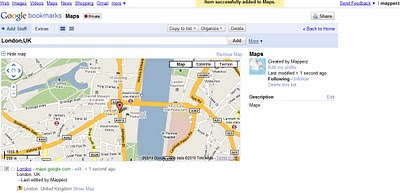
Google Bookmarks Your Maps

Google Bookmarks Your Maps

Simple, no lon
g urls can be private or public (to share)

"
Today we’re debuting lists in Google Bookmarks, an experimental new feature that helps you easily share those sites with friends."

Google Bookmarks Share Maps
Google bookmarking your maps - Tip: With the Google Toolbar simply click the star and it will be saved in your favourite bookmarks. No need to worry about very long urls that can be broken in emails etc.

https://www.google.com/bookmarks/l (Google Account Required)

Privacy
http://www.google.com/support/bookmarks/bin/answer.py?hl=en&answer=159231

Using Maps with Google Bookmarks
http://www.google.com/support/bookmarks/bin/answer.py?hl=en&answer=162168

source:
http://googleblog.blogspot.com/2010/03/collaborative-bookmarking-with-lists.html

Labels: , , , ,

11 March 2010

UK Streetview - FULL Coverage

UK Streetview - FULL Coverage

updated...

http://maps.google.co.uk/?ie=UTF8&hq=&hnear=United+Kingdom&ll=53.343993,-5.185547&spn=8.217413,23.269043&z=6
(and drag the yellow pegman)

Longest unbroken Trip in Streetview for the UK now possible

http://mapperz.110mb.com/GMAP/LongStreetView_UK.html
838 mi (about 15 hours 2 mins)

England, Wales, Scotland and Northern Ireland Full Coverage.

(Republic of Ireland streetview coverage is likely in due course.)

New Content:

Visit Wales in Streetview
http://tinyurl.com/visit-wales-view
NationalTrust in Streetview (better coverage)
http://tinyurl.com/NationalTrust-view

Note:some images are over 1 year old since google recorded them.

Big Brother is now complete for the United Kingdom.

mapperz

Labels: , , , , , ,

10 March 2010

Biking Directions on Google Maps - New!

Biking Directions on Google Maps - New! (in beta)
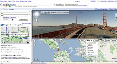
Biking Cycling Directions on Google Maps in Beta
Green 'highlighted' lines are specific for Cyclists using Google Bicycle directions

  • Bike lanes: For more than 150 cities in the US, we know which streets have dedicated bicycle lanes. These are also prioritized when coming up with a routing suggestion. On the bicycling layer, you’ll see these roads indicated in bright green.
  • Recommended routes: For many cities we also provide information on streets that have been designated as good for cyclists, so we them into account in our algorithm. These roads are indicated with dashed green lines on our bicycling layer.
  • Uphill slopes: l don't know anyone who enjoys biking up a hill, especially when you're trying to get somewhere you need to be. Going uphill is worse than simply being much slower; it's also exhausting and can take a toll on the rest of your ride. Our biking directions are based on a physical model of the amount of power your body has to exert given the slope of the road you’re biking on. Assuming typical values for mass and for wind resistance, we compute the effort you’ll require and the speed you’ll achieve while going uphill. We take this speed into account when determining the time estimate for your journey, and we also try hard to avoid routes that will require an unreasonable degree of exertion. Sometimes the model will determine that it's far more efficient to make you ride several extra blocks than to have to deal with a massive hill. My teammates in San Francisco were relieved to see that this does indeed work!
  • Downhill slopes: Many cyclists will tell you that going downhill is annoying for a different reason: you may have to ride your brakes all the way down. All else equal, we try to avoid routes that require a lot of braking. Of course, in some cities, including my hometown of Seattle, this isn’t always possible! And if you feel like you need a big workout and want to climb some hills, or if you just love that wind-in-your-hair feeling of a long downhill (you better be wearing a helmet and staying safe!), you can always turn on the terrain layer to check out the hilliness of an area for yourself.
  • Busy roads: Cyclists often tend to prefer to stay off of fast roads, and not even cross them unless it's necessary. This is roughly the inverse of driving directions, where you want to stay on arterials and freeways, so we had to rework a lot of those fundamental calculations when coming up with our biking directions algorithm.
  • Busy intersections: We try to avoid making you cross busy streets with a lot of car traffic and long wait times.


Try it (US only currently)
http://maps.google.com/biking
(goes into official mapplet mode)

The Official Blog Post is now available:
http://googleblog.blogspot.com/2010/03/biking-directions-added-to-google-maps.html

and official cross blog post
http://google-latlong.blogspot.com/2010/03/its-time-to-bike.html

updates
@Mapperz

Labels: , , , , ,

09 March 2010

New Google Geocoding Web Service

New Google Geocoding Web Service

The service is now 'not limited' but you are required to show the results on a Google Map.
Examples given to help user understand the importance of this update.
Lots of updated content and improvement from feedbackNew Service v3 Geocoding
  • Unlimited Usage*
  • Status Codes (in Plain English!)
  • Java Support (Parsing XML with XPath)
"*Note: the geocoding service may only be used in conjunction with a Google map; geocoding results without displaying them on a map is prohibited."
[2,500 requests may be sent to the Geocoding Web Service per day from a single IP address]

but purley for example based on the official example given
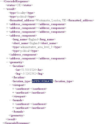
Geocoding London (UK)
http://maps.google.co.uk/maps/api/geocode/xml?address=London&sensor=false
New Google Geocoding Web Service

Reverse Geocoding 51.5001524,-0.1262362 (London)
http://maps.google.com/maps/api/geocode/xml?latlng=51.5001524,-0.1262362&sensor=false

Countries Support
http://spreadsheets.google.com/pub?key=p9pdwsai2hDMsLkXsoM05KQ&gid=1
Note: en-GB ENGLISH (GREAT BRITAIN) enabled

New Status Codes - now in Plain English
  • "OK" indicates that no errors occurred; the address was successfully parsed and at least one geocode was returned. example
  • "ZERO_RESULTS" indicates that the geocode was successful but returned no results. This may occur if the geocode was passed a non-existent address or a latlng in a remote location. example
  • "OVER_QUERY_LIMIT" indicates that you are over your quota. (your geocoding too fast!)
  • "REQUEST_DENIED" indicates that your request was denied, generally because of lack of a sensor parameter. example
  • "INVALID_REQUEST" generally indicates that the query (address or latlng) is missing. example
Now for the new content:

geometry contains the following information:

* location contains the geocoded latitude,longitude value. For normal address lookups, this field is typically the most important.
*location_type stores additional data about the specified location. The following values are currently supported:
o "ROOFTOP" indicates that the returned result is a precise geocode for which we have location information accurate down to street address precision.
o "RANGE_INTERPOLATED" indicates that the returned result reflects an approximation (usually on a road) interpolated between two precise points (such as intersections). Interpolated results are generally returned when rooftop geocodes are unavailable for a street address.
o "GEOMETRIC_CENTER" indicates that the returned result is the geometric center of a result such as a polyline (for example, a street) or polygon (region).
o "APPROXIMATE" indicates that the returned result is approximate.
* viewport contains the recommended viewport for displaying the returned result, specified as two latitude,longitude values defining the southwest and northeast corner of the viewport bounding box. Generally the viewport is used to frame a result when displaying it to a user.
* bounds (optionally returned) stores the bounding box which can fully contain the returned result.

Java Support
Parsing XML with XPath

Although it is not as lightweight as JSON, XML does provide more language support and more robust tools. Code for processing XML in Java, for example, is built into the javax.xml packages
please see http://code.google.com/apis/maps/documentation/geocoding/#XMLParsing for full details.

Full Documentation (updated)
http://code.google.com/apis/maps/documentation/geocoding/
Official Blog Post
http://googlegeodevelopers.blogspot.com/2010/03/introducing-new-google-geocoding-web.html
Mano Marks (Google Geo Developer Advocate)
http://randommarkers.blogspot.com/2010/03/client-side-geocoding-rocks.html

Full terms and conditions
http://code.google.com/apis/maps/terms.html#section_10_12
Maps API Terms
http://code.google.com/apis/maps/terms.html

Labels: , , , , , ,

25 February 2010

Google Fusion Maps - February 2010 Update

Google Fusion [Tables] Maps - February 2010 Update - More Powerful
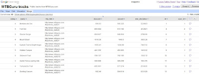
An Interesting update here in a previous blog post
Note: Suggestions, would be nice to be able to overlay the thematic map [based in flash] over the Google Map (or creating gpolygons). Sharing with the option of embedding and link to would be convenient.

Well seems like this service has improved:
How?
  • Some new features that will let you upload and map large amounts of geographic data.
  • You can also now hide and show different data depending on your own criteria.
  • Create Custom HeatMaps with your own data.
  • You Do NOT need to be a Developer.
  • Embed Your Map to your website or blog.
Google LatLong Blog has a great example of the new power (without being a developer)
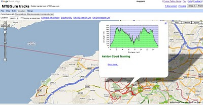
Google Fusion Tables Routes Datasource
Go from the this table of Bike Tracks.. http://tables.googlelabs.com/DataSource?dsrcid=11310

to a nice bike tracks map with routes and altitude on a map with little or no programming.
Google Fusion Tables Routes Mapped

Points are displayed at small scales but zoom in and routes of bike tracks are displayed very fast on the map Note: Goto 'Visualize >Map
http://tables.googlelabs.com/DataSource?dsrcid=132848

http://www.mtbguru.com/ is responsible for this first example using this method, mapperz highly recommends readers to look at the blog post: http://blog.mtbguru.com/2010/02/24/mtbguru-tracks-as-seen-through-google-fusion-tables/
which goes through the motions clearly on how to do this. Then you can try it with your own datasets.

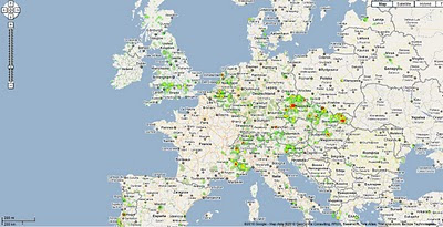
Create Heatmaps
Google Fusion Tables Routes Heatmap
You can even create Heat Maps simply with your own data.

A great way to get started on mapping your own data.

Embed the Map:


(for the coders)

Using iframe
iframe width="500px" height="300px" scrolling="no" src="http://tables.googlelabs.com/embedviz
viz=MAP&q=select%20col0,col1,col2,col3,col4,
col5,col6,col7,col8,col9,col10,col11
%20from%20132848%20where%20col11%20%3E%20'70'&h
=false&lat=49.85392252759648
&lng=14.85626220703125&z=9&l=col10"/iframe

Under the hood:
http://maps.google.com/maps?gwt=1&file=api
&client=google-fusiontables&sensor=false&v=2.x">

var map = new GMap2(document.getElementById("map_canvas"));
map.setCenter(new google.maps.LatLng(49.98,14.88),9);
var l = new GLayer("span style="font-weight: bold;">ft:132848");
<< style="font-weight: bold;">select+col10+from++132848/span"); 
Select column 10 from fusion table ID

map.addOverlay(l);
map.setUIToDefault();
map.addControl(new GMapTypeControl());
map.addControl(new GLargeMapControl());
map.addMapType(G_PHYSICAL_MAP);

Source and More details on http://google-latlong.blogspot.com/2010/02/mapping-your-data-with-google-fusion.html
credit to http://www.mtbguru.com/

Labels: , , , , , ,

09 February 2010

New Street View Coverage for Norway & Finland

New Street View Coverage for Norway & Finland
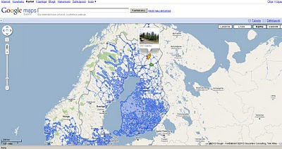
update:
Canada has large coverage updates too
Canada Streetview Expands
New Canadian Coverage (substantial)
Yukon (Whitehorse)
Northewest Terroritories (YellowKnife)
Alberta (example Grande Prairie)
Bristish Columbia (example Prince George) (also includes Snow Mobile Streetview)
Saskatchewan (Example Prince Albert)
Manitoba (Lake Winniepeg)

Google Maps Street view Finland
New Suomi (Finland) Street View Coverage

View the New Coverage
and drag the yellow pegman, drop on anywhere that is blue.


Google Maps Street view Norway

Norge (Norwegian) Street View Coverage

View the Norge Streetview


Also available on the Desktop via Google Earth see
http://www.gearthblog.com/blog/archives/2010/02/streetview_added_to_norway_and_finl.html

Source:
http://googlemapsmania.blogspot.com/2010/02/street-view-arrives-in-norway-finland.html

Labels: , , , , , , , ,

10 January 2010

Photospots.co.uk Maps (OS & Google)

Photospots.co.uk Maps (OS & Google)

"A website for amateur photographers to share their favourite photography locations."

Photospots.co.uk Google Map
Very clean site with direction of the sun and location of the photograph clearly show for each individual shot.

UK photograph locations have the additional maps from Ordnance Survey Openspace

Photospots.co.uk OS Map
Switching from Google Maps to Ordnance Survey is extremely well implemented no page refreshing required making this very user friendly and usable.

Map and Photographs viewable
http://www.photospots.co.uk/

Blog
http://www.photospots.co.uk/blog/
Well done to Andrew Rickmann http://twitter.com/photospots/

Geograph
A similar and much more established photographic by map location project http://www.geograph.org.uk/ is hugely popular. [1,560,388 images]
"The Geograph British Isles project aims to collect geographically representative photographs and information for every square kilometre of Great Britain and Ireland"

Access to these images can be made by the Geography API.
http://www.geograph.org.uk/help/api

Here under educational licence is a slippy map version
http://www.geograph.org.uk/mapper/

See previous mapperz post on Geograph
http://mapperz.blogspot.com/2007/11/new-draggable-geograph-map-beta.html

Labels: , , , , ,

02 December 2009

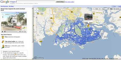
Google Streetview Singapore Released

Google Streetview Singapore
http://maps.google.com.sg/maps and drag pegman....

Labels: , , ,

10 November 2009

Street View - Gran Canaria & Tenerife.

Street View - Gran Canaria & Tenerife. (Hawaii too)
Street View Gran Canaria
Gran Canaria
Street View Tenerife.
Tenerife

Don't Forget the 50th State of the United States too. Hawaii

Official Blog
http://googleblog.blogspot.com/2009/11/fifty-states-of-street-view.html

Labels: , , , ,

Google Street View Mexico Arrives

Google Street View Mexico Arrives


Mexico City

Monterrey
Guadalajara
Puerto Vallarta
Cancun
Playa del Carmen
Cozumel

nice views on the Google Maps Mania Blog
http://googlemapsmania.blogspot.com/2009/11/mexico-gets-street-view.html

Labels: , , ,

13 October 2009

Google Building Maker - New!

Google Building Maker - New!

Contributors will be able to help creat buildings for over 50 cities.
(likely to expand in the future)
Building Maker Cardiff UK

"We [Google] like to think of Building Maker as a cross between Google Maps and a gigantic bin of building blocks. Basically, you pick a building and construct a model of it using aerial photos and simple 3D shapes – both of which we provide. When you're done, we take a look at your model. If it looks right, and if a better model doesn't already exist, we add it to the 3D Buildings layer in Google Earth. You can make a whole building in a few minutes."


The YouTube Video shows how fast it is to add/contribute your own buildings, Google will check them and when verified they will acknowledge your work.Creating Building Maker Cardiff Model Building
Building Maker in Cardiff - with simple tools to create buildings

Requirements before you can contribute:
  • Building Maker is an online tool, and it runs entirely in your web browser (Google Chrome, Firefox, Safari, Internet Explorer, etc.)
  • Before you can add a building to Google Earth, you need to sign in to your Google Account (so you get credit for what you contribute).
  • Models you create with Building Maker "live" in the Google 3D Warehouse (a giant, online repository of 3D models).
  • You can use Google SketchUp (the free, general-purpose 3D modeling tool) to edit or otherwise modify anything you make with Building Maker.
  • Make sure you have the latest version of Google Earth installed on your computer.
  • If using an Apple Mac, you need to download the Google Earth plug-in directly.
Google Building Maker
http://sketchup.google.com/3dwh/buildingmaker.html

source:
http://google-latlong.blogspot.com/2009/10/introducing-google-building-maker.html

Labels: , , , , , ,

08 October 2009

Google StreetView for Canadian Cities - New!

Google StreetView for Canadian Cities - New!

Seems a long time waiting but finally Google Street View comes to Canada.
Google Street View Canada

The service is now available in much of the Greater Toronto Area and in Vancouver and the surrounding area, north to Whistler (2010 Winter Olympics Venues) and east to Chilliwack, British Columbia


Google Street View is also available in the Ontario cities of Hamilton, Kitchener, Waterloo, Ottawa also Calgary, Canmore, Banff and Lake Louise in Alberta, Montreal and surroundings, Quebec City and finally Halifax in Nova Scotia.


Source and embedded StreetView Scenes available at
http://googlemapsmania.blogspot.com/2009/10/street-view-comes-to-canada.html

Don't forget you can embedded your own StreetView tours easily with
http://www.streetcities.com/

Labels: , , , , , ,

28 August 2009

BBC Breathing Places Maps

BBC Breathing Places Maps

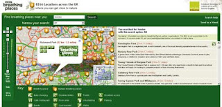
BBC Breathing Spaces Maps
A nice and clean friendly Google Maps with simple icons to guide you to "BBC Breathing Places"

"Breathing Places has some brilliant ideas for rolling up your sleeves and making your very own place for nature – right on your doorstep."

We [The BBC] want to help you get friendlier with wildlife and give you lots of ideas on how you can do just that.

Enjoying the outdoors will do you some good and, as long as you're careful, you will do some good for wildlife as well. It's as simple as doing one thing, no matter how big or small that one thing is. Or if you're really keen you can do lots and lots of one things.

Map Tips:
You can use the drop down menu so your search only shows places with events/ walks within the next week/month, places that need volunteers or places with a particular event theme.
Icons:
Click a single leaf icon to see a bubble with info/links for that place. Multiple (tiled) leaves indicate several places. If the places are too close together to show separately, clicking the leaves shows a bubble with a list of places. If there are too many places to show, clicking the leaves will zoom the map in.

Example Map:
http://www.breathingplaces.org/public/search?location=London&has_js=1&Search.x=0&Search.y=0

Help Guide (for the Map)
http://www.bbc.co.uk/breathingplaces/help.shtml

**Database developed in collaboration with Natural England

Full A to Z of all the 'Places' available currently.
http://www.breathingplaces.org/public/browseplaces/a

For Teachers
http://www.bbc.co.uk/breathingplaces/schools/

Coming Soon is Breathing Places Communities
http://www.bbc.co.uk/breathingplaces/communities/

Labels: , , , , ,

26 August 2009

Google Map Static Map Upgrade (v2)

Google Map Static Map Upgrade (v2)

New Features Encoded Paths, Polygons & Geocoding

update:
here is a useful tip or two using 'MyMaps' created features:
http://imagine-it.org/google/staticmap/encodemymap.php
(thanks to @pamelafox)

Google have made some changes - many top requested features have been included, but due to these feature requests there are some changes required for you code.

  • Locations (in center, markers, or path parameters) can now be specified as addresses instead of latitude/longitude coordinates.
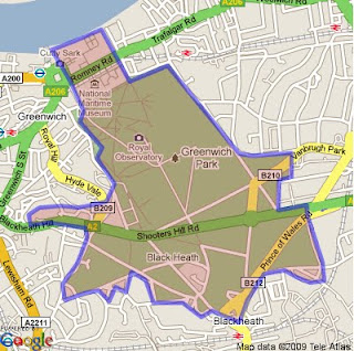
  • Paths can be specified as encoded polylines.
  • Paths can be filled and rendered as polygons.
  • Colours can now be specified as any 24-bit or 32-bit colour.

Use of the Google Static Maps API is unchangedwith a query limit of 1000 unique (different) image requests per viewer per day

Google Static Maps v2
encoded polygon in Google Static Maps v2

http://maps.google.com/maps/api/staticmap?size=400x400&path=fillcolor:0xAA000033|color:0000ff|enc:ykfyHln@bBtLhJkI|JyGdChAzHiL
|BfBvH}IlEvCl@tG%60@rGYjIXbLpApEbC_@a@kJ~@cUpB_@tH~D~FzG%60Eg@
qAeK[iGvBgEeDwB%60A}EuFwA|AqGvG_D?_QdDiJgAiElCuOkGuC_I_Is@iK|
AuFz@_GYuGuEj@{PtG_CTbA~OsJKa@sFcH?XrVQhGi%60@dj@zDdVwRdPrCbO
&key=YOUR API KEY&sensor=false


Note: The fastest way to create an encoded polygon is to create a polygon in Google Earth then right click the polygon and copy & paste into this site

http://facstaff.unca.edu/mcmcclur/GoogleMaps/EncodePolyline/encodeForm.html
check your polygon is located correctly. The click then 'Show Code'
The line {points:
contains the encoded polygon. use this for your static map.

Having been re-written The Static Maps API v2 changes are:

red=old green=new
  • Instead of specifying maptype=mobile, specify the desired map type (like maptype=hybrid) and the parameter mobile=true. This way, we can provide mobile optimised tiles for every map type.

  • The colour for a path is now specified using "color", not "rgba":

    For example:
    &path=rgba:0x0000FF80,weight:5|37.40303,-122.08334|37.39471,-122.07201|37.40589,-122.06171
    becomes:
    &path=color:0x0000FF80|weight:5|37.40303,-122.08334|37.39471,-122.07201|37.40589,-122.06171

  • Similar to how the path styles were specified before, the marker styles are now specified using key:value pairs, separated by pipes [|]. Marker labels are now denoted using uppercase alpha characters instead of lowercase alpha characters.

    For example:
    midreda
    becomes:
    size:mid|color:red|label:A

  • Instead of specifying the marker style after each marker parameter, specify the style at the beginning of the markers= parameter, and that style will apply to all of the markers proceeding. If you want to show markers with different styles, just supply a new markers= parameter for each one.

    For example:
    markers=37.400465,-122.073003,midreda|37.437328,-122.159928,midreda|37.369110,-122.096034,smallblue
    becomes:
    markers=size:mid|color:red|label:E|37.400465,-122.073003|37.437328,-122.159928&markers=size:small|color:blue|37.369110,-122.096034

  • Marker labels now require uppercase alphanumeric characters in the label parameter. This will allow us to later supply lowercase characters if we wish.

    For example:
    markers=37.400465,-122.073003,midreda
    becomes:
    markers=size:mid|color:red|label:E|37.400465,-122.073003

  • Instead of using the span=parameter to make sure that your static map shows a particular viewport, use the visible= parameter instead, and specify a list of coordinates that must be shown.

    For example:
    center=0,0&span=20,20
    becomes:
    visible=10,-10|-10,10

  • The frame parameter is no longer supported.

After upgrading your existing functionality, you might be interested in adding some of the new API functionality to your website.

Tools: Make A Static Map Wizard (V2)

http://gmaps-samples.googlecode.com/svn/trunk/simplewizard/makestaticmap.html

Source:

http://code.google.com/apis/maps/documentation/staticmaps/upgrade.html

Labels: , , , , , , ,

18 August 2009

Google Maps News - Street View & Map Maker

Google Maps News - Street View & Map Maker

update:19/09/09
Mexico is now available for Map Maker - please see the official blog post
http://google-latlong.blogspot.com/2009/08/map-maker-goes-west.html

StreetView has been expanded again this now covers
Switzerland and Portugal and also Taipei City in Taiwan

New Street View Chapel Bridge, Lucerne
Chapel Bridge, Lucerne with new Streetview coverage.

Google Maps Mania does a very good round-up of the coverage included
http://googlemapsmania.blogspot.com/2009/08/street-view-arrives-in-switzerland.html


Google Map Maker has been opened up some more with download-able vector data available for Africa [Terms of Use Apply]. This is either in KML format or Shapefile.

On the Mapmaker creation side Eastern Europe has now been opened up for editing.
This includes Albania, Belarus, Kosovo, Macedonia, Moldova, Montenegro, Romania and Serbia.
More news on this here
http://google-latlong.blogspot.com/2009/08/map-maker-gets-european-flair.html

Map Maker Africa Download
This data can be obtained by accepting the terms of use at this link
https://services.google.com/fb/forms/mapmakerdatadownload/
This data can be used in a GIS or Google Earth Application.

Labels: , , , , , , , ,

31 July 2009

Google Maps Flash API - 3D Perspective

Google Maps Flash API - 3D Perspective

"2-D maps are great, but sometimes it's cool to gaze into the distance. Today we're happy to announce support for perspective"

Google 3D Perspective Directions Panoramio - Flash Maps
Official Example:Driving Directions with Panoramio along a route in 3D Perspective

You can manipulate the 3D map using the same keyboard controls as you use on Google Earth and within the Maps API. Clicking and dragging moves the map in the direction being dragged, as you would expect. When dragging the map while holding down an optional modifier key, however, you can alter the attitude of the map:

  • SHIFT alters the rotation and attitude of the map around a clicked point.
  • CTRL (or the Apple key) alters the rotation and attitude of the map from the point of view of the camera.

Flash Map Google UK Weather
Ian Watkins has created this 3D perspective UK Weather Map


Keir Clarke (Google Maps Mania fame) points out to @mapperz the nice youtube video that demonstrates the flashiness of the UK Weather Map

The key and simple code to make the changes are:

Map3D.viewMode = View.VIEWMODE_PERSPECTIVE;

and replace the old position and zoom controls with the
new navigation control:


addControl(NavigationControl);
Full details and documentation
http://code.google.com/apis/maps/documentation/flash/3d-maps.html

Want even more Flash Demos
http://code.google.com/apis/maps/documentation/flash/demogallery.html

Official Blog Post and Source:
http://googlegeodevelopers.blogspot.com/2009/07/3d-perspective-in-maps-api-for-flash.html

Labels: , , , , , ,

25 June 2009

Google City Tours (Labs)

Google City Tours (Labs)

Google City Tours Google Labs - London


Google Labs " Google City Tours" which uses Google Maps. The idea is that anyone can locate points of interest and plan up-to three day trips in major cities.

City Tours has a number of tours for pre-set for San Francisco, New York, London and Dublin. Major landmarks, museums and art galleries are available in each of the cities.


Landmarks can be edited on your own tour using the google map. Info windows display this information for the markers includes user rating and the opening hours. The Sidebar shows the order of the walk and the time it should take to walk from one location to the next.

City Tours Example - London Day 2
Mapperz Suggestion: The walking directions should follow the walkable path for the streets and not as the crow files in this case. Hopefully this gets an update.

Try it here
http://citytours.googlelabs.com
[Google account require to edit and save/rate tours]

Related post:
http://googlemapsmania.blogspot.com/

Labels: , , , , , , ,

11 June 2009

Google Fusion Tables [Fast Batch Geocoding]
Google Fusion Tables [Fast Batch Geocoding]
"A fast an effective way to batch geocode spreadsheet data."

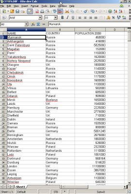
World Cities Population in Open Office
Take some data, with no geographic information. Upload to the New Google Fusion Tables and Map it.

Some spot checking of data in location - as geocoding is not an exact science.
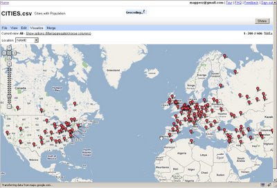
World Cities with population checking locations

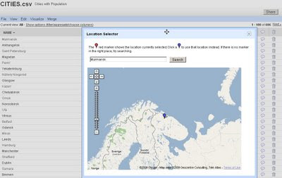
Simply import the data will then give you access to 'Map' the data.

Automatic Batch Geocoding
Then the real magic of automatic batch geocoding on the fly - you can visually see the data being placed on the map.
All within a few seconds - then whole process takes less than 30 seconds [based on 606 cities] though only 1-200 markers are display at one time.

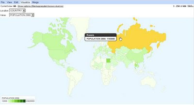
And to finish it off - it is easy to create a simple thematic map.Population Summary Thematic Map

Suggestions, would be nice to be able to overlay the thematic map [based in flash] over the Google Map (or creating gpolygons).
Sharing with the option of embedding and link to would be convenient.
*Note currently in Google Labs things will change.

A nice tool with great potential has unique features and powerful visualization functions.

Summary
Google Chart meets Google Maps with Google Spreadsheets binding them.

Related
http://googlemapsmania.blogspot.com/2009/06/
google-fusion-tables-google-maps.html

Official Post
http://googleresearch.blogspot.com/2009/06/google-fusion-tables.html

Labels: , , , , , , , ,