->

30 April 2007

Geotagging N95 Camera Photos to Google Maps

Geotagging N95 Camera Photos to Google Maps

update 30/04/2007
Ogle Earth reviews Digital Urban's post and ShoZu (more info).

Digital Urban beat Mapperz to it (had done this in practice, honest).

Digital Urban N95 Geotagged Photo
The result Geotagged Photo in Google Maps, Content from Digital Urban.

To do this you will need:
1x N95
1x ShoZu
1x Yahoo/Flickr Account
1x Google Account

So will hand you over for full details
http://digitalurban.blogspot.com/2007/04/how-to-geotag-
photographs-from-nokia.html


N95 users notes a special additon of ShoZu is coming out for the N95 soon.
"Thanks for your review of ShoZu :-) We're working on a special version for the N95 with a few cosmetic fixes and also the ability to automatically 'wake' the gps antenna without you having to load the Maps app in the background."
Source: Digital Urban comments

We look forward to it.

Labels: , , , ,

25 April 2007

Yahoo Maps India

Yahoo Maps India

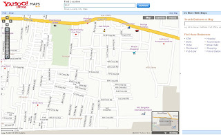
Yahoo found India now it is mapped

Yahoo Maps India
Yahoo Maps India

Mumbai Yahoo Maps India
Mumbai

Yahoo Maps India Bangalore
Bangalore Airport

So where is next?
Antarctica anyone...?

Labels: , , , ,

Google Spreadsheets - Geocoding

Google Spreadsheets - Geocoding (well almost...)

Mapperz looking for London (UK), but gets the wrong London!

*Please note this is not a full solution and it might seem to geocode, but check all locations.

Not really documented on the geocoding side but the is =GoogleLookup function that seems to understand "latitude" and "longitude" in a request formula in Google Spreadsheets

Here is an example (google account holders can edit and see the function)
http://spreadsheets.google.com/pub?key=pAxR-aN5DCiWkZ60GpHxJOQ

Google Spreadsheets Geocoding Nearly
Note 'London' is not London,UK but London (Kentucky)

Same goes with Paris, no it's not Paris, France but Paris, Kentucky

detecting a pattern here?

But potentially a useful service, though some standards are needed to be able to get the correct users location, maybe "Location, State/County, Country"

For more information on this have a look at Ogle Earth post on it.

Sticking to having lat and lng fields in the spreadsheet and using google maps with
javascript:void(prompt(%22http://www.google.co.uk/search?
q=%22,gApplication.getMap().getCenter()));
(copy and paste that code, if doing lots create a bookmark, FireFox works best)

More details on that script on a previous post.

Labels: , , , ,

24 April 2007

My Maps in Your Blog +KML

My Maps in Your Blog +KML


Nice simple and quick to do.

http://www.dr2ooo.com/tools/maps/

Easier if you have created a KML output in My Maps
for fast indexing of kml use google pages (google servers index very fast)

source:
http://tim.lauer.name/2007/04/23/embed-google-my-maps-map-into-your-blog/


mapperz

Labels: , , , , , ,

20 April 2007

Multimap - Rolls Out API Services to Businesses

Multimap API - Rolls Out new services to businesses

How do you improve a mapping service?
(with over 10 million unique users 190 million page impressions a month)

The API was reported back in February 2007. By Mapperz
http://mapperz.blogspot.com/2007/02/multimap-api-updated

-includes-uk.html

With a few updates and lots of testing of the service, multi-map launch this service.

API Chart

The Multimap API v.1.2 is routing, mapping, geocoding, using POI data and imagery into a single one-stop mapping service.

Multimap Map Widget
One new change - the Map Widget can show how the API can show points of interest of various kinds around a location on a map.
more on this

Summary (there is quiet a bit)

• Mapping - draggable maps with ‘fast fill’ smooth zooming; suite of widgets (including location breadcrumbs, overview map, map tools, zoom slider); custom menus, map interactions and events; custom markers with automatic ‘de-clutter’, tabbed info boxes, dynamic text and icons; and choice of map types (map, aerial imagery*, hybrid*) and styles (local*, global) – (* where available).

• Searching - choice of search modes, including search by radius, location ID, bounding box, donut and driving distance, search along route and non-spatial search; custom result ordering, pagination and display; fuzzy searching (including starts with, ends with, contains, sounds like); and plug-and-play POI data.

• Routing - point-to-point, multiple via points and ‘travelling salesman’ optimization; multi-language directions; multi-modal routing (e.g., drive to here, then walk to here) and avoid specific road types; choice of outputs (text, highlight, ‘expense claim’, summary); enabled for route animation.

• Geocoding - single point of access to Multimap’s full, best-in-class geocoding capability; high-accuracy, high-performance geocoding; and Javascript and HTTP access.

• Local Information - Points of Interest (POI) can be easily displayed on maps, and routed to and from. Multimap provides access to a large range of POI, including schools, transportation, restaurants and bars, ATMs, car parks and more.

“We are proud to offer the latest version of our API service to the industry. Ease and speed of implementation are key considerations driving many businesses to embrace the new service, with the ability to be up and running with a highly interactive, signature site in a matter of hours."
Sean Phelan, founder of Multimap

Source of Press Release: Directions Magazine

Labels: , , , , , ,

17 April 2007

More N95 Free Applications - including more GPS & Maps

More N95 Free Applications - including more GPS & Maps Apps

(a few tips and tricks at the bottom)

Mapperz N95 installed apps
Yes all the above Apps here are on Mapperz N95 and are Free to Download and use.

In Summary from top left
  1. Google Maps
  2. MGmaps
  3. Google Mail
  4. Sports Tracker (Nokia)
  5. F-Secure
  6. J2MeMaps
  7. TruWiz (Voice over IP)
  8. NSysInfo
  9. S-Tris-2 (Tetris)
  10. scanR (OCR)
  11. Screenshot
  12. Live Messenger
Smart2Go - Maploader (Nokia)
Okay, here is a few free applications some mapping and some not. For the N95's out there.
Standard Mapping Application with the N95 - Map Data is Vector and downloaded to Memory Card (MicroSD 2GB card - from Moby Memory) via the Smart2Go Maploader Software.

Nokia Maps - London in 3D Mode
London in 3D with all Points of Interest (POI's) on. Joystick rotates on the blue square.


Google Maps on N95 - easy to Install and use.
Google Maps on N95


Mobile Gmaps - as above but includes, Microsoft, Yahoo and Ask Maps as optional maps
MGmaps on N95


Sports Tracker in GPS mode, shows distance, time, speed and location, exports to google earth kml

Nokia Sports Tracker with live GPS

Would work better with the preloaded maps, though GPS fix is fast and plenty of real-time data been fed back to the user. Tip get a GPS fix before you start your workout. Standing still also helps GPS locate you faster

Nokia Sports Tracker with live GPS

So you can't have Internet Calling (Voice Over IP) on Orange (UK)?
Well Mapperz can
Orange N95 with Internet Calling Working
The little phone and world icon is Internet Calling Active any Outgoing Calls are using the T'internet connection and if move out of Wifi Range it flips over to Orange (UK) GPRS EGPRS
works like a normal call. Also picks up other Wifi unsecure networks and uses them. So in theory free calls forever?
Fring are to be next with an N95 Voice OverIP
Truphone does work with a free £2/$2 start up.


To Unlock your phone http://www.blueghost.co.uk/unlock_guide/unlock.html
for a guide. Use at your own risk.

Top Tips for N95 Users -
Reset your N95 to Factory Settings before use - for faster GPS Fixes.
Switch off Applications, Bluetooth, Infrared, Wifi re-scan etc to improve battery life in GPS mode.
Format your new MicroSD Card on the phone first before connecting to a PC via USB.
Load the Map Application before you load any map data to the device, this puts important files and folders on your memory card, and makes loading the map data faster when in use.

And one careful tip, this device is very loud when used in media/video/game mode - even 50% is very loud, careful when use switch to earphones - you will hurt your ears.

Get a car charger if being navigated over 2 hours by this device.

Spare batteries for the N95 are in high demand... grab one if you can!

Keep and eye on http://www.nokia.com/betalabs

mapperz

Labels: , , , , , ,

ArcGIS 9.2 Service Pack 2 Released

update
Service Pack 3 is now available 01/08/2007
http://mapperz.blogspot.com/2007/08/arcgis-92-service-pack-3-released.html

The ArcGIS 9.2 Service Pack 2 is released for download to solve all your bugs with ArcGIS 9.2.1 (?)

ArcGIS 9.2.2 (build 1350)

ArcGIS Service Pack 2 Desktop Administrator
This is what is fixed - all 15 pages.

In summary with direct links to the downloads

ArcGIS Desktop (ArcInfo, ArcEditor, ArcView)
ArcGISDesktop92sp2.msp 87 MB
ArcGIS Desktop Help updates
ArcGISDesktopHelp92sp2.msp 335 MB
ArcGIS Desktop Developer Kit for the Microsoft .Net Framework
DesktopSDKDNet92sp2.msp 46 MB
ArcGIS Desktop Developer Kit for Visual Basic 6
DesktopSDKVB692sp2.msp 1 MB
ArcGIS Desktop VBA Developer Resources
DesktopSDKVBA92sp2.msp 1 MB
ArcGIS Desktop Developer Kit for Visual C++
DesktopSDKVCPP92sp2.msp 75 MB
ArcReader
ArcReader92sp2.msp 46 MB
ArcView 9.2 Evaluation Edition
ArcGISEvalEdition92sp2.msp 87 MB


ArcGIS Engine Runtime
ArcGISEngine92sp2.msp 62 MB
ArcGIS Engine Developer Kit for C++
ArcGISEngineSDKCPP92sp2.msp 69 MB
ArcGIS Engine Developer Kit for the Microsoft .Net Framework
ArcGISEngineSDKNet92sp2.msp 46 MB
ArcGIS Engine Developer Kit for the Java Platform
ArcGISEngineSDKJava92sp2.msp 1 MB
ArcGIS Engine Developer Kit for Visual Basic 6
ArcGISEngineSDKVB692sp2.msp 1 MB
ArcGIS Engine Developer Kit for Visual C++
ArcGISEngineSDKVCPP92sp2.msp 66 MB


ArcGIS Server for the Microsoft .Net Framework
ArcGISServerDotNet92sp2.msp 215 MB
ArcGIS Server Web ADF Runtime for the Microsoft .Net Framework
ArcGISServerWebADFRuntime92sp2.msp 6 MB
ArcGIS Server for the Java Platform
ArcGISServerJava92sp2.msp 209 MB

ArcGIS Server Post Install Workaround

Labels: , , , , , ,

16 April 2007

Get A Little Extra - Tesco Maps

Get A Little Extra - Tesco Store locater maps
Easy uncomplicated store and nearest stores locater, click on icons (markers) for the opening times, address and contact numbers.
Tesco Map
"Find Tesco store locations on a Virtual Earth map of the UK with an optional satellite image overlay. Hover the mouse over a location to get directions, or click on the name of the store to view its address, phone number and store hours."

http://www.tesco.com/storelocator

includes
  • Tesco Extra (the largest stores)
  • Tesco Express (small convenience stores)
  • Tesco Metro (food only small stores)

There are more out there than you think!

Uses Microsoft Virtual Earth,Live Local, Live Maps (enter another name here in two days).

"It's been named MSN Virtual Earth, Windows Live Local, Windows Live Maps, Live Search Maps and now Live Maps."
Official Source Virtual Spaces Blog


Mapperz

Labels: , , , , ,

12 April 2007

Google Maps goes 2.5D

Google Maps goes 2.5D
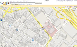
First there was plain old maps, then building outlines, now they have grown... upwards
Google Maps 2.5D

See New York in 2.5D in Google Maps.

Other US Cities have also been updated.

Mapperz

Labels: , , , ,

Canada Adopts Free Model for Map Data

Ordnance Survey take note!
Rationale for charging has gone, says government information expert

"If you've got a computer and a fast connection, you can now download all the maps and satellite pictures you could ever want of Canada. Its government has decided to abandon the charging model that it used until last month for the use of its map data and move to a "free data" model - as being urged for Britain by Technology Guardian's Free Our Data campaign"

What about the copyright of the data?

"Another part of the move loosens the ties on the data - although Canada still uses Crown Copyright, it only asks for acknowledgement of the source. We suspect Canada will see the benefits quite soon. Will the UK follow?"
Source: The Guardian - reported by Charles Arthur

Yes Please -sooner rather than in 50 years (when the map data will be out of copyright) by the time they have unwrapped the red tape from the crown copyright issues.
Free our data!

So if you want Canadian Data - and have plenty of free disk space download from these sources

http://www.geobase.ca

http://geogratis.cgdi.gc.ca/geogratis/en/index.html


Labels: , , , , ,

11 April 2007

BlueGhost Integrates GeoRSS Maps

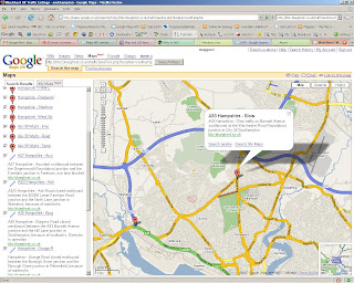
The BlueGhost Project nows uses Google Maps Enhancements to provide up to the minute Travel Incidents across the UK.
BlueGhost GeoRSS and Google Maps

Live Feed Link
http://maps.google.co.uk/maps?q=
http://bbc.blueghost.co.uk/travel_data/locations.rss

Clicking on the blueghost.co.uk inside the icon info window will link to a new map of just that selected area.

BlueGhost GeoRSS Southampton and Google Maps

Markers Represent there is a Incident and the Lines Represent the Road is Closed.

This works very well with live data and shows the full potential of GeoRSS feeds - providing users with up-to-date information.

Well Done to Michael Pritchard (Blueghost creator) for creating this and other very useful data feeds that are displayed in map form.

Other Blueghost maps
http://bbc.blueghost.co.uk/site4.php
(Traffic, Rail and Weather on Google Map - with nice icons)

Labels: , , , ,

09 April 2007

N95 Free Applications - including GPS & Maps

N95 Free Applications - including GPS & Maps

N95 in the Box
Source: Mapperz (this blog (via adsense) helped buy this device!))

To Start an Official Application (Supports Google Earth Output- KML)

Sports Tracker
"If you own a N95 one of the first things you should do is download the recently released free application 'Sports Tracker' from Nokia. Sports Tracker is aimed at the sports or general user on foot or cycling and more importantly it provides full route tracking with the ability to upload to Google Earth."
Source and More Info at Digital Urban

MapLoader and the Standard Software on the PC>Phone does the Job.
(though have a day to hand loading the maps on - 150mb took 6 hours)

Though recommend you only use this for Foot and Car Naviagation in Semi-Urban and Urban Areas. Or if you do hill walking, hiking and mountaineering this software is not for you.
The solution here would be to be able to import your own maps.

update:more free official apps here

Mobile GMaps
"Mobile GMaps is a FREE application that displays Google Maps, Yahoo! Maps, Windows Live Local (MSN Virtual Earth) and Ask.com Maps and satellite imagery on Java J2ME-enabled mobile phones, PDAs and other devices. MGMaps can connect to a GPS receiver over bluetooth or use internal GPS features on some phones in order to automatically display the map for your current position."
More Info and Download at mgmaps


Online Data Backup
All this Data but what if the phone goes down and and out have not backed up your phone?
"Store your mobiles phone numbers, calendar and SMS safely with ZYB. Sign up now, and get a copy of your precious mobile content"
https://zyb.com/

A Very Fast Calculator
Try this simple example: start the standard calculator and do 2/3 x 7. It takes 13 clicks. Using Calcium it only takes 6!
More Info
http://mtvoid.com/calcium/

Like to Stay in Contact?
Via Wifi or EGPRS*

http://mobile.live.com/wml/

http://mobile.yahoo.com/go


http://code.google.com/p/mobile-google-talk-http/

or use this app for all three
http://www.gizmoproject.com/
(Yahoo! Messenger, Google Talk, or Windows Live)

Free Phone Calls? (using Voice Over IP)
Using Wifi or EGPRS*
Fring

EGPRS* is charge by data transfer - depending on your network operator and mobile tariff this can vary in cost. Use Wifi if you can!
http://en.wikipedia.org/wiki/Enhanced_Data_Rates_for_GSM_Evolution
_Rates_for_GSM_Evolution

add a comment if you know of more!

mapperz

additions pending.... mapperz approval


Labels: , , , , , , ,

05 April 2007

My Maps Service - New from Google Maps

All New from Google Maps 'My Maps' - Make your own Custom Maps with help from Google Maps

Like this....
My Maps New from Google Maps
(note mapperz not really having Tea with the PM purely for example reasons and testing this useful service out)

So how do you get this to work?
Easy if you have a Google account. If you want one you can sign up here
Login and go to http://maps.google.co.uk
or your localized area eg http://maps.google.com

Click on My Maps New
In the Left Table of Contents

You will notice some new icons appear
My Maps New Icons Edit Mode
Pan, Create Marker, Create Line, Create Polygon
Now Search for your area of interest, 10 Downing Street, London, UK in this instance
this will zoom into and place a 'found' marker to show you the centre point.

Now you can add your own marker (like mapperz has to locate Number 10)

This is easy to create and edit, you can have as many markers as you like.

Google provide a tool tips help when using the point, line and polygon in edit mode.
Drag to move vertices polygon edit mode

Want to edit the colour and transparency of the polygon?
easy

Editing polygon fill transparency
Transparency or Fill Opacity can be changed so that the background mapping can be seen.
Default is 45, (100= solid fill, 0= no fill)

Okay now you have a go!

Top Tip: If you want a KML file so you can view in Google Earth you can use the KML Icon in the Top where 'Link to Page' is located.

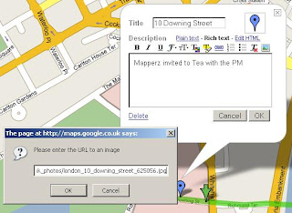
To add an image - use the 'Rich Text' Mode
Add images to my maps rich text mode
Click on the image icon on the toolbar and find a copyright free image or your own which is hosted on a webserver/site.Copy Image Location on the image and paste into the prompt on the My Map Editor as above.

The same can be done with Video from the likes of You Tube, MySpace etc.

For a more interactive tutorial (video) please visit the following (after the ad)
http://news.com.com/1606-2_3-6173473.html?tag=ne.vid

Want more information on this?

Google Earth Blog does a good round-up of this new service...

"The really interesting aspect to the announcement is that the underlying data is all KML! KML is the file format for Google Earth content - and now Maps too. This means you can create your maps and then click on the "KML" in the upper right of the map and immediately view the content in Google Earth. Furthermore, when you search for content you will not only be able to get local business search results, but also get KML search results (just like the recent KML search update for Google Earth). Look for a "See user-created content" link after the other results - it only appears when there is relevant content searched in the current view (see example)."

Source: Google Earth Blog

more info to feed on here...

Official Post: map-making-so-easy-caveman-could-do-it
Official 'My Maps' Help: http://maps.google.com/help/maps/userguide/index.html

And of course Google Maps Mania blogged it.

mapperz

Labels: , , , ,

PdMarker 2.01 (for Google Maps)

Updated PDMarker 2.01 (for Google Maps)

PdMarker 2.01

Peter Jones has been busy, updating the very useful PdMarker.
Available here for detailed instructions and tips.

Don't forget that the is a very good Virtual Google Earth to help create a Google Map with Markers - this would be good for the 'My Maps' service

for the new feature and functions
"http://www.pixeldevelopment.com/pdmarker_testbed.asp
This page allows you to try and see how most of the features of
PdMarker work without writing any code. You can also test these
features using a specified version of the Google Maps API. Some
PdMarker features (setImage, display) now rely on a Google Maps API version of at least 2.77. "

mapperz likes the bit 'without writing any code'

Note: Data Export Options
Exporting to JS, XML,KML and HTML is available

Labels: , , ,

04 April 2007

New Version of Live Maps Launches

A new version of Live Maps Launches (Live Local, Virtual Earth, Microsoft)

Firefox 3D Live Maps Microsoft Officially Supported
In Summary
  • Firefox support (officially supported) for 3D mapping (hooray)
  • Ratings and Reviews of Business Listings and Details page enhancements (USA Only)
  • Subscribe to a Collection via RSS.
  • Area Calculations and Drawing Enhancements
  • Traffic and Driving Directions Enhancements
  • Address-Only Geocoding
  • Live Search Maps for Outlook is Updated
  • Twitter 3D map in Virtual Earth (see link)

In detail here

Labels: , , , , ,

Viewing KML on Mobile Devices

Viewing KML on Mobile Devices

As most know about view KML directly via google maps

like this file


http://maps.google.co.uk/maps?f=q&hl=en&q=
http://mapperz.110mb.com/Mapperz.kml&layer=&ie=UTF8&z=17&om=1

Well you can now do this via a mobile device.
Here's how
Have a Java based phone.
Go to http://www.mgmaps.com/
Download the latest release, currently
MGMaps version 1.33.01, released on April 2nd, 2007
from
http://wap.mgmaps.com/get.php?version=13&platform
=main&submit=Download
Download the JAR or JAD file
use Bluetooth, USB or WAP to do send the file to your phone/pda.
Install the application, (It is safe)
Run MGMAPS
You get a Google Map, this is default. Yahoo, MSN and ASK maps are also available.

for adding KML add your map - select options menu> 3. Services and a sub menu has View KML. Select this and then enter the address in full and it is case sensitive.
http://mapperz.110mb.com/Mapperz.kml
This load the file and then can be overlay on the map.

pics to be included... happy mapping.

mapperz


Labels: , , , ,

01 April 2007

Nokia N95 - part 1, The Navigator (Smart2go)

Nokia N95 - part 1, The Navigator (Smart2go)

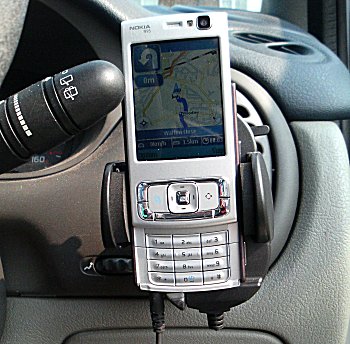
N95 in Action in Car
Image source: allaboutsymbian

A first clear and detailed review of the N95 (super duper smart phone) and the Smart2go mapping application.
Officially Released Tomorrow (2nd April 2007) in the UK.

in summary the review points out:
the pluses +
  • maps are basically completely free
  • option to have all maps stored on your expansion card or to grab them as needed over GPRS or 3G (cheaper to get them via wifi)
  • Navigation always intuitive
  • Route planning was as good as any other
  • 2D and 3D view Mapping (like a TomTom)
  • The zoom/scale is adjusted dynamically
minuses -
  • Navigation is not free (approx £30 (€50)) per year for turn by turn info
  • tediously slow, nokia maploader servers are slow due to high demand (leave overnight to download)
  • Battery life in GPS mode is approximately 1 hour from a full charge (best used with 12v car charger for navigation)
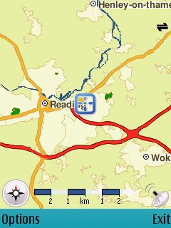
N95 in Action Reading Map
Image source: allaboutsymbian

Overall this combination of an all in one smart device and mapping is the start of bring all the 'now' technologies (gps,wifi,3g etc) together to make a very useful and handy for everyday life.

read in more detail at http://www.allaboutsymbian.com/reviews/item/Nokia
_N95-part_2_the_Navigator.php

Labels: , , , , , , ,