->

26 December 2009

The London Of Sherlock Holmes...Mapped

The London Of Sherlock Holmes...Mapped
Sherlock Holmes Film (2009)
The New movie and the New Map of Locations
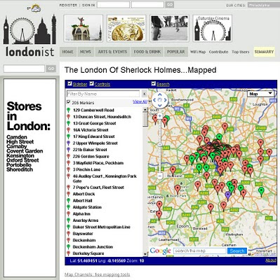
Sherlock Holmes Map London Locations
Find the locations of Sherlock Holmes and even some answers to clues on this Map of Sherlock Holmes in London.


The whole world is about to go Sherlock Holmes bonkers, due to the Warner Brothers movie starring Robert Downey Junior and Jude Law and Directed by Guy Ritchie of Lock Stock and 2 Smoking Barrels and Snatch fame.

"With each new telling, the character receives a certain amount of reinvention. One thing is constant, though. London. You can't have Holmes without the city he was so intimately associated with. But which parts of town did he know best? Our well of nerdiness will never run dry, so we re-read all the original Holmes tales and plotted every London location on the map above.

Some interesting patterns emerge. Naturally, there's plenty of action around the Baker Street area, but Holmes never once set foot in nearby Soho. Zooming out, there's a surprising cluster of incidents around Crystal Palace. The reason is elementary when you know that Sir Arthur Conan-Doyle lived for a time in South Norwood. We haven't plotted the numerous out-of-town locations mentioned in the books, but you can get a sense of Holmes' peregrinations by noting which rail stations he used most. Southern stations Charing Cross and Waterloo are visited a combined total of 16 times, while King's Cross and Euston are only blessed with the detective's patronage on four occasions."

Key: Green = precise location; red = imprecise location; purple = real-world Holmes-related sites; blue line = route taken by Holmes. Page numbers refer to those in the Folio Society's 1994 collection

source: The Londonist

Created by the Excellent Tools at Map Channels

View the Map
http://londonist.com/2009/11/the_london_of_sherlock_holmesmapped.php

Official Film (2009)
Official Website for the New Movie
http://sherlock-holmes-movie.warnerbros.com/


Labels: , , , , ,

23 December 2009

'Ordnance Survey Free' 23rd December 2009

'Ordnance Survey Free' 23rd December 2009

The document that everyone has been waiting for ;

"Policy options for geographic information from Ordnance Survey Consultation"

Ordnance Survey Website April 2010
Will the Ordnance Survey Website have a direct link to your free data in April 2010?

Ordnance Survey Free products from 1 April 2010 is shown below. It includes digital reference
products and digital display products:

Raster Free Products:
Vector
  • Code-Point - that's full grid refrenced postcode data
  • Boundary-Line - a specialist 1:10 000 scale boundaries dataset
  • Meridian 2 - transport network and topographic themes
  • Strategi - 1:250 000 scale topographic database

The products that are released as part of Ordnance Survey Free will continue to be
maintained by Ordnance Survey to a high and consistent standard. The product set
may evolve over time.

Ordnance Survey Free is intended to allow communities to combine (or “mash-up”)
government data about their community and environment from a number of sources
and illustrate their findings in a geographic context:

The raster products will enable developers to produce an application that overlays
their information on a map and to zoom-in from a national view with MiniScale
down to the street level with OS Street Viev, the gazetteer, boundary and postcode information will enable widespread use.

These commonly used geographies and it will act as a link between other
government data sets which reference the same geography
the 1:50 000 Scale Gazetteer provides a definitive source of town and place.

names to search and locate a place of interest on the map

Code-Point provides the location of every postcode to enable accurate search and display of specific locations and it will link to other data with a postcode reference

• Boundary-Line provides the outline and a unique reference to all the
administrative and electoral units of Great Britain.

• Meridian2 and Strategi are small scale vector products which provide the
geometry of features to allow customisation and combination with other data.
Meridian 2 includes a full named and attributed road network.

Issues - none is there?

Issues highlighted by Ordnance Survey:
The most immediate impact on Ordnance Survey as a result of the release of
Ordnance Survey Free products will be the reduction in revenues.
Three different types of existing and future revenue loss have been identified, and their potential impact on Ordnance Survey quantified.
These include: direct revenue impacts as a result of the loss of revenue from the products to be released for free; product substitution affecting Ordnance Survey’s remaining products, which will arise as customers switch to Ordnance Survey Free products; and increased competition impacts as competitors are able to derive their own products from the Ordnance
Survey Free products.

The estimated that the revenue loss to Ordnance Survey from a combination of
these three effects would be £19-24m p.a. Further growth was anticipated in these
products, which could now be foregone.

The provision of Ordnance Survey Free datasets and associated services has been
assessed on the basis of avoidable cash costs at £6-8m p.a. over the next five years,
including both the operating costs and on-going investments required for these
products. In addition there would be one-off development costs for data provision of
up to £1.1m.

source:
http://www.communities.gov.uk/documents/corporate/pdf/1415413.pdf [PDF]
[Section 7]

Labels: , , , , ,

20 December 2009

OpenOrienteeringMap

OpenOrienteeringMap

OpenOrienteeringMap is an orienteering map of the whole of the UK, based on OpenStreetMap data. There are two map types – “Street-O” and “Pseud-O”.

OpenOrienteeringMap Pseud-O Map Mode

The Pseud-O map is a less serious map (as the level of detail in OSM is not sufficient for “proper” orienteering maps) but attempts to emulate the look and feel of standard orienteering maps.

OpenOrienteeringMap Street-O Map Mode

The Street-O map contains the level of detail equivalent to the Street-O maps used for informal orienteering races around the streets of London and other urban areas in the UK.

Both maps make (loose) use of the ISOM and ISSOM [see pdf's] orienteering mapping specifications, particularly the colours and the styling. Measurements are less likely to be within spec, due to artistic considerations and limits of standard screen resolutions.

When accessing the website, you initially see a “cloud” of place names. Pan to your area of interest, then zoom in a few times until you start seeing the orienteering map.

Because the maps are based on the “Tile Mapping Service” standard, they are viewable only at fixed scales. The current scale is displayed on the bottom right of the map.

The most relevant scales for orienteering are 1:7000 and 1:14000 – these are the scales you will see, assuming a 72dpi screen.

Large areas of the UK are still missing much detail at Orienteering scales . You can help build the free map of the UK by contributing to the OpenStreetMap project, by surveying your local area and adding the roads, land types and other data into the project. The data is then pulled into OpenOrienteeringMap on an approximately monthly basis. The current data is from the beginning of November 2009.

Known bugs in the Pseud-O Map:
* At river mouths, there is generally a black line drawn across the “border” between river and
the sea – in some cases (e.g. the Mersey), this line protrudes far out into the sea.
* Brown road ends are not crossed off with a black border-line.
* Several layering assumptions are made. For example, it is assumed that water is always underneath roads and railways.
* No north lines or arrow – and the map is orientated to true north rather than magnetic north.
* No contours – yet. OpenCycleMap tiles?
* The background maps (OSM/Aerial) do not work in Internet Explorer 6, as the Street-O map tiles’ transparency does not work on this browser.

Other things to bear in mind:
* Performance in Internet Explorer is quite slow (although it does just about work.) Use of Firefox, Safari or Chrome standards-compliant web browsers is strongly recommended for this and other websites.
* The website delivers multiple layers of full-colour PNG graphics, so you’ll need a fast broadband connection (at least 3Mbps) and a fast computer to be able to pan around the maps in real-time.
* The maps are created on-the-fly but are cached, so subsequent visits to an area should be faster to view. The server can only support a few people using the site at once, so if it’s running slow, be patient or come back later.
* Only the UK is covered at the moment but the map could very easily be extended to cover the whole world – it’s just a case of getting the data in the database.

If you have any comments or suggestions for improvements in the clarity, styling and colouring, please send an email to (mail (at) oliverobrien.co.uk) Note that Ollie cannot help fix the data – this should be done with the editing tools in OpenStreetMap – however if you have made a significant improvement to an area and would like it reflected in OOM before the next data refresh, by all means let Ollie know.

source & original post:
http://blog.oobrien.com/oom/ full credit to Ollie O’Brien

View the Map - Milton Keynes
http://oobrien.com/oom/?layers=B00FFTT&zoom=15&lat=52.03717&lon=-0.76533

Labels: , , , , ,

17 December 2009

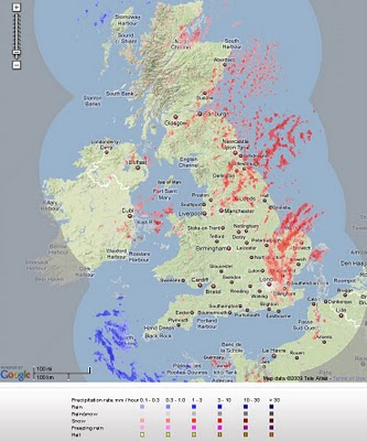
Live Snow Radar Map UK

Live Snow Radar Map UK
*almost live

Live Snow Radar - UK Map
Pink and Red highlights snowfall - blue and purple represents rain.

"Radar is a remote sensing tool used by weather forecasters to analyse the extent and intensity of precipitation. Radar detects objects by transmitting radio waves which are reflected back to the starting point by any object they encounter. Distance can be calculated using the speed of the radio waves and the amount of time that each pulse takes to reach the object and return back to the starting point. Rain, snow and hail all stop the radio waves. The more pulses that are reflected back, the greater the intensity of the precipitation."

http://www.raintoday.co.uk/static/about_radar.html


View the map in near real-time
http://www.raintoday.co.uk/

powered by Meteogroup and Google Maps API

source: @mapperz

Labels: , , , , , , ,

16 December 2009

BBC Crash Map: Death on Britain's roads

Crash Map: Death on Britain's roads

Not a great topic be but a blunt reality...

"For an everyday activity, travelling by road is probably the riskiest thing many of us do on a regular basis."

BBC Crash Death Map - Thames Valley
The map spans dates from 1999 to 2008 and highlights where deaths occured and what nature and how many deaths. Thames Valley (Police Authority) seem to have had a successful downward reduction in road deaths across the time period.
Main causes - Speeding, Mobile/Cell use and Drink Driving (alcohol)
Lots of Motorway deaths seem to be lorries (trucks) and passenger cars - the blind spot?

On average, some seven people are killed every day on the roads in Great Britain. Hundreds more are injured, many of them seriously, often with life changing consequences.

In 2008, 2,538 people died on Britain's roads, on average nearly seven every day. Using official data released by the Department of Transport, this map plots the location of every fatal road crash in Great Britain between 1999 and 2008, a total of 32,298 deaths.

Select a police authority or type in a postcode to discover where fatal road crashes occur. Click the yellow markers to get more detail. For 2008 we have included some links to stories – both BBC news and others – to convey some of the grim reality behind the statistics.

Source and interactive map (bing map):
http://news.bbc.co.uk/1/hi/uk/8412891.stm

Labels: , , , , , , ,

14 December 2009

Mapquest Streetview (called 360) - Street Level Imagery

Mapquest Streetview (called 360) - Street Level Imagery
Mapquest Steetview 360
You can now view MapQuest Maps in a whole new way. We have developed a simple, easy-to-use interface that fits seamlessly into the MapQuest mapping experience you have come to know and understand. 360 View provides fantastic panoramic views (360° horizontally and 160° vertically) of any given image within the 360 View coverage area
*selective USA Cities only
Mapquest Steetview 360 mode
orange glow represents 360 street level imagery available when the '360 view' option is on.

The quality of the imagery is not as high resolution as Google (Streetview) or Bing Streetside but then they require post-processing bluring faces, mapquest does not.
The Orange 'bubbles in' 360 mode could be made transparent but do indicate direction of the next photo in a simple manner.


Mapquest API
currently 360 mode is not available in the mapquest api
http://developer.mapquest.com/web/products/beta-releases

source:
http://blog.mapquest.com/2009/12/11/street-level-imagery-comes-to-mapquest-com-as-360-view/
screen shots:
http://www.mapquest.com/360-details

Labels: , , , ,

11 December 2009

Planning a big event? - Marquee Venues Mapped

Planning a big event? - Marquee Venues Mapped

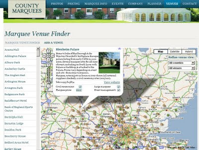
There are maps for almost anything, here is a site that can give you access to marquee sites and locations in South East England.
These are for small to very large events (weddings, rock festivals, sport events and corporate events.

Marquee Venues Mapped
Numerous locations that can accommodate large marquee events

http://www.countymarquees.com/venues.htm

This site does well due the integration of locating, planning events and gives clear and full specifications of all types of marquee's available.

In additional users can update this map with locations that accommodate these large shelters.

Geographical Areas covered:
  • London
  • Sussex
  • Surrey
  • Oxfordshire
  • Kent
  • Hampshire
  • Essex
  • Hertfordshire
  • Berkshire
  • Bedfordshire
  • Buckinghamshire
Equipment

Map

Neat 'undercover' Marquee Planner

Labels: , , , , , ,

08 December 2009

Birds Eye View - Google Maps API - New

Birds Eye View - Google Maps API- Aerial Imagery
*limited coverage currently
**currently only available via the Google Maps API V2)

Users of Bing Maps (Virtual Earth/Live Maps fame) will recognised this maptype.

Birds Eye View Google Maps - New Map Mode
New Map Mode - Tilted Aerial Imagery comes to the Google Maps API.
(techies call it oblique aerial and its taken from aircraft from the side or front)
getmapping has a good set of examples
http://www2.getmapping.com/Services/Obliques


"Starting today [8th December 2009], developers will have access through the Google Maps API to high-resolution overhead imagery that is presented in a new aerial perspective. This is currently available in 2 spots in California: San Jose and San Diego. This new perspective gives users the ability to tilt their view of the world. In addition to seeing hotel rooftops like in our current "satellite" view, users can now see both the rooftop and sides of the hotel at an angle. In fact, users can rotate around all the sides of a hotel to get 4 different views from back to front"

2 Official Blog Posts
http://googlegeodevelopers.blogspot.com/2009/12/getting-better-view-with-maps-api-v2.html

http://google-latlong.blogspot.com/2009/12/changing-your-perspective.html

"What's great about this new imagery is that all of your existing data and Google Maps services like driving directions can be displayed on your map with no extra work. This is a result of a lot of code and computing power that reprojects the imagery to make it easy to overlay data on the map given lat/lon locations like in any other Google Map type. The result is a great user experience together with easy display of data on the map"

Documentation
http://code.google.com/apis/maps/documentation/introduction.html#AerialMapTypes

Examples:

Simple
http://code.google.com/apis/maps/documentation/examples/aerial-simple.html
Now with Auto-rotate
http://code.google.com/apis/maps/documentation/examples/aerial-rotation.html

@mapperz uber widescreen version (1200x800)
http://mapperz.googlepages.com/Aerial_RotateGoogle_Maps.html

Labels: , , , , ,

05 December 2009

Ordnance Survey Ireland Map 'Shop' Viewer

Ordnance Survey Ireland Map 'Shop' Viewer

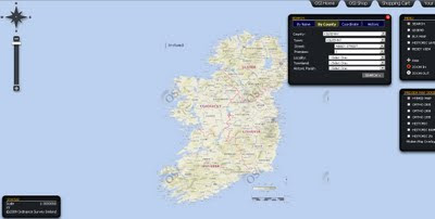
Ordnance Survey Ireland Map Viewer
Map Viewer, shop by map, digitised/scanned maps all in one location

Between 1829 and 1842 Ordnance Survey Ireland (OSI) completed the first ever large-scale survey of an entire country. Acclaimed for their accuracy, these maps are regarded by cartographers as amongst the finest ever produced.

As the national mapping archive service for Ireland, OSi has captured this and later mapping data in a digitised format. Through this website you can view and download this data or place an order for delivery by post.

The new archive currently comprises the following series of maps:

  • 6 inch mapping series (1:10,560) colour 1837-1842
  • 6 inch mapping series (1:10,560) greyscale 1837-1842
  • 25 inch mapping series (1:2,500) greyscale 1888-1913
  • The above historic maps, originally surveyed on a county basis, now make up Ordnance Survey Ireland's digital image archive. Every image in the archive has been captured from an original print and each digital map image is now a seamless map title within the archive.

    With an easy-to-use browser you can search by county or townland. You can also pan across the entire archive and zoom in to view sections in greater detail. All A4 size historic products purchased from the online shop are delivered via PDF electronic download only. For larger A0 size historic products, we deliver by post only.

    *Certain mountain and moorland areas were mapped to a 6 inch scale only. These particular areas will appear as gaps when viewing the 25 inch map series online.

    source:

    http://www.mjhughes.co.uk/index.php/2009/12/04/os-ireland-mapping-portal/

    View the Shop by Map Viewer

    http://ims0.osiemaps.ie/website/publicviewer/main.aspx


    other OSI products that might interest you.
    Wind Map
    http://shop.osi.ie/Shop/Products/Default.aspx#wind

    Labels: , , , , , ,

    03 December 2009

    BING Maps Explore (Streetside)

    BING Maps Explore (Streetside)
    *Sliverlight required & in beta
    **Streetside mode is in some USA Cities only currently

    BING Maps Explore Streetside
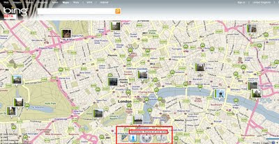
    Looks familiar to Google StreetView but is a light blue indicating 'StreetSide' coverage.

    BING Maps Explore Streetside - Streetside Mode
    Streetside mode - has similar features to streetview, controls are slightly different.

    BING Maps Explore Map Apps
    Apps for your BING Maps - Nearby App (useful), Traffic, Twitter App displays geo-tweets, many more to explore.

    BING MAPS BETA NEARBY CLUSTER MARKERS
    Nearby Map App- Markers(Icons) group in clusters when there is not enough space to display all markers at zoom levels.

    BING MAPS BETA STREETSIDE
    BING Maps Explore has new controls - automatic 'finds' the best map mode for your zoom level

    try it
    http://www.bing.com/maps/explore/

    warning to firefox users - can cause memory leaks and freeze up your browser.

    source:
    http://www.bing.com/community/blogs/maps/archive/2009/12/02/bing-maps-adds-streetside-enhanced-bird-s-eye-photosynth-and-more.aspx

    Labels: , , , , , ,

    02 December 2009

    Big Street View Update for Canada

    Big Street View Update for Canada

    Street View Canada update Victoria & Nanaimo
    Canada has had a large update of Street View - Victoria, British Columbia is new
    along with

    Edmonton, Saskatoon, St. John’s, Winnipeg, Victoria.


    Small update for United Kingdom
    Eden Bio-domes Streetview Coverage
    Kew Gardens
    Warick Castle
    EDEN Project
    Stonehenge
    ITV [UK TV Channel] have 'Coronation Street'

    Sources
    http://www.mcwetboy.net/maproom/
    http://maps.google.ca/
    http://maps.google.co.uk/

    official post
    http://google-latlong.blogspot.com/2009/12/more-street-view-updates-see-sea-see.html

    updates throughout the day at http://twitter.com/mapperz

    Labels: , , , , , ,

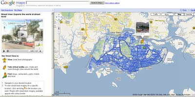
    Google Streetview Singapore Released

    Google Streetview Singapore
    Google Streetview Singapore
    http://maps.google.com.sg/maps and drag pegman....

    Labels: , , ,