->

29 June 2010

Happy Mappy 5th Birthday - Google Maps API

Happy Mappy 5th Birthday - Google Maps API

Google Maps API was released 5 years (today) ago and now there are 350,000 unique map 'mashups' truly amazing. Good luck to the next 5 years!

5th Happy Mappy Birthday - Google Map API
Keir Clarke - Google Maps Mania author created this 5th Birthday Google Map Mashup to display messages and map mashup - you can contribute by adding your message....

from the Official Post:
"Today is an important milestone here at Google and we’re all pretty excited - the Google Maps API turns 5! It was five years ago today that we posted a brief announcement to let the world know about the JavaScript Maps API and now 5 years later more than 350,000 active websites make use of it. Uses have ranged from tools that have made it easier to find an apartment, track the Gulf of Mexico oil spill and even make an Earth sandwich! Many, many more examples have been chronicled on sites like Mashable and the Google Maps Mania blog. In 2005, Adrian Holovaty launched the first crime mashup that overlaid Chicago’s public crime data onto online maps providing Chicago’s citizens and journalists with a true picture of crime in their city. The site won the 2005 Batten Award for Innovations in Journalism and was named by The New York Times as one of 2005's best ideas. In honor of this very special birthday, we took a chance to check back in with Adrian to see what he thought about the journey of the Google Maps API over the past 5 years:"

“Of my 11 years of doing Web development, Spring 2005 was the most interesting and exciting time. When Google Maps launched -- with maps assembled client-side, in JavaScript! -- I was one of the band of tinkerers around the globe who poked at Google's obfuscated code until we figured out how to embed their maps in our own pages. It was a ton of fun, not only doing the reverse engineering, but seeing the various discoveries and hacks other people were making: embedding multiple maps in a single page, swapping out the map tiles, using custom map markers, making markers move, loading real-time data onto maps... New discoveries were being made on a seemingly daily basis, and the best ones built on the other ones, which led to a sense of a community contributing to a greater understanding.

“These days, it's hard to fathom a Web without embeddable maps. Wasn't it always that way? To Google's eternal credit, instead of shutting these hacks down, they recognized the demand and legitimized it in the form of their mapping API.

“And the rest is... well, kind of boring in its simplicity, now that reverse engineering isn't involved. There was something raw and pure about those original hacks, like hunting and skinning your own food, living off the land, a digital self-sustainability. I feel like an old man yelling at kids to get off my lawn: ‘Back in my day, I had to reverse engineer Google's obfuscated JavaScript to get embeddable maps on my pages!’ You don't know how good you have it.”

The Google Maps API has seen some significant milestones of its own during the past five years. Some of the announcements we’re most proud of are the Maps API for Flash, Static Maps API, our Enterprise offering Maps API Premier, and the new Maps API v3, built with mobile use cases in mind and recently graduated from Code Labs. The Google Maps API has established itself as the most popular Google API and the most deployed service-based API on the web. We continue to be amazed by how popular this API continues to be for web and mobile apps being developed today. This ProgrammableWeb dashboard shows that of the apps built and submitted over the past 2 weeks, a quarter of them make use of the Google Maps API. Click the 'All Time' tab and you'll see that nearly half of the almost 5000 cataloged mashups use it.

Today, on this 5 year milestone, we really have all of you to thank for this incredible chapter in web and mapping development. The remarkable levels of innovation, creativity and interest have come from all of you. You saw the possibilities the Google Maps API held and what it could be combined with to create, and you built it. Now join us to celebrate! Keir Clarke from Google Maps Mania has created a mashup that we want all of you to contribute to. Please tag your Google Maps mashup or tool to the map wherever you are:

Birthday Map
http://mappybirthday.appspot.com/

Original Post by Mike Pegg (former author & creator of Google Maps Mania)
http://googlegeodevelopers.blogspot.com/2010/06/big-birthday-google-maps-api-turns-5.html

Labels: , , , , , ,

28 June 2010

Download ESRI ArcGIS 10 - Released

Download ESRI ArcGIS 10 - Released

Finally ArcGIS 10 has put the 'E' back in Environmental Systems Research Institute

updated: 21:38 BST 28th June 2010.

Read the Requirements before thinking of downloading

"ESRI (UK) is pleased to announce that ArcGIS® 10 will be available shortly. ArcGIS 10 will revolutionise how organisations use geographical data and delivers a host of new possibilities."

"The ArcGIS 10 software will be available as a download from week commencing 28 June or on DVD at a later date." [But when?]

Users with a maintenance plan can download the software (3.2GB +8.0GB for ArcGIS 10 Data)ESRI ArcGIS 10 Released - Downloadable

ESRI UK has re-vamped their site to include ArcGIS 10 (not just re-directing to the US site)

Here are the links (note: don't try downloading whilst viewing videos unless have a super-fast broadband connection)

ArcGIS 10 Demos:

Introduction to ArcGIS 10
Usability Enhancements (10 usability enhancements in ArcGIS Desktop)
3D in ArcGIS 10 (display, analyze, and maintain 3D data in ArcGIS 10)
Enhanced Map Editing (enhanced map editing tools and workflows)
Modeling and Analysis (more productive, access data faster, and generate better models and results)
Mapping Workflows ( create, manage, and share your maps more efficiently)
Production and Automation (Python window in ArcGIS 10 MapBook, Sharing)

UK Users of UK Specific Products

UK Product Compatibility Status

ProductCompatibility Date
ProductivitySuiteJuly 2010
CrimeAnalystAugust 2010
LocalView FusionAugust 2010
LocatorHubSeptember 2010
http://www.esriuk.com/arcgis10/existing_customers.asp
Full Product list

Please note the web browsers below are supported for the ESRI Customer Care Portal from which our customers will download ArcGIS 10
Internet Explorer: version 6+
FireFox: all versions
Chrome: all versions
Safari: all versions
Opera: 9+
Additionally users will need Flash Player 9+ installed and JavaScript enabled to use the site.

FILE SIZES - BIG
Product LineProducts Available for DownloadFile Size (approximate)
ArcGIS DesktopArcGIS Desktop 103.2 GB

ArcReader 101.6 GB

ArcGIS Desktop Tutorial Data 102.0 GB

ESRI Data & Maps for ArcGIS 108.0 GB


ArcGIS Server EnterpriseArcGIS Server Enterprise 10 for Windows3.0 GB

ArcGIS Server Enterprise 10 for Red Hat Linux Enterprise and SUSE Linux Enterprise3.2 GB

ArcGIS Server Enterprise 10 for Sun Solaris on SPARC3.2 GB

ArcSDE 10 for Windows1.0 GB

ArcSDE 10 for UNIX2.5 GB

ESRI Data & Maps for ArcGIS 108.0 GB

ESRI Data & Maps for ArcGIS Server 108.0 GB


ArcGIS Server WorkgroupArcGIS Server Workgroup 103.5 GB


ArcGIS Engine Developer KitArcGIS Engine Developer Kit 10 for Windows2.6 GB

ArcGIS Engine Developer Kit 10 for Red Hat Linux Enterprise and SUSE Linux Enterprise and Sun Solaris on SPARC2.75 GB

ArcGIS Engine Runtime 102.6 GB


ArcGIS Engine RuntimeArcGIS Engine Runtime 102.6 GB


ArcIMSArcIMS 103.4 GB

ArcIMS Gazetteer0.65 GB


ArcInfo WorkstationArcInfo Workstation 10 for Windows & Sun Solaris on SPARC1.9 GB


ArcGIS Image ServerArcGIS Image Server 100.50 GB


ArcGIS Workflow ManagerArcGIS Workflow Manager 100.07 GB


ArcGIS Server Workflow ManagerArcGIS Server Workflow Manager 100.08 GB


ESRI Mapping and Charting SolutionsESRI Production Mapping 100.25 GB

ESRI Aeronautical Solution 100.35 GB

ESRI Defense Mapping 100.40 GB

ESRI Nautical Solution 100.35 GB


ArcGIS Data ReviewerArcGIS Data Reviewer 100.10 GB


Tracking ServerTracking Server 100.50 GB


ArcPadArcPad 100.20 GB

ESRI StreetMap Premium Tele Atlas North America (USA and Canada)2.0 GB

ESRI StreetMap Premium Tele Atlas Europe3.0 GB
US Site:

Labels: , , , , ,

25 June 2010

State of the Map 2010 - Girona, Spain - Open Street Map

State of the Map (SotM 2010) will be held in Girona, Spain from the 9th - 11th July 2010

State of


the Map!

SotM 2010 location by using Open Street Map

http://www.openstreetmap.org/?lat=42.6&lon=3.11&zoom=6&layers=B000FTF&mlat=41.98523&mlon=2.81161

"The 4th Annual State of the Map is in beautiful Girona, Spain. Consisting of three days, you have fantastic opportunities to discover how OSM is used in business, meet new international OSM friends and tune up on your mapping skills.

Friday starts off with a bang on Business day. Want to use the freely available OpenStreetMap map data in your business? Opportunities abound to hear how other enterprises utilize OSM. You’ll also gain insight on tools that are available to hit the ground running with OSM! Business day is simply a powerful day not to miss. Check out our Friday program.

Community, community, community! The weekend is all about the great clan that is OSM. Packed with talks, panels and social events, all day and into the night! New to OpenStreetMap? Come and meet us and learn what we are passionately working on, who the movers and shakers are and join in on the fun! Have a look at our program for Saturday and Sunday."

Schedules is here: http://stateofthemap.org/schedules/
Mapperz interesting picks:

Friday 9th July 2010: http://stateofthemap.org/schedules/friday/
"Geodata from public sector sources" sounds interesting
Saturday 10th July 2010: http://stateofthemap.org/schedules/saturday/
"Outreach to Non-Technical Communities" sounds promising.
Sunday 11th July 2010: http://stateofthemap.org/schedules/sunday/
"What I’d like to do with Mapnik" cartographic changes coming?

Promotion links of State of the Map 2010
Twitter some of SOTM's tweets to your many followers: http://twitter.com/sotm

Or tweet something new, like this cool new video about the conference: http://stateofthemap.org/impressions/

Blog:Write a quick blog post - be inspired by some SOTM blog posts:

http://stateofthemap.org/program-announced-for-the-state-of-the-map-2010/

Labels: , , , , ,

23 June 2010

Met Office Events Weather Maps

Met Office Events Weather Maps

Whether your interested in The World Cup in South Africa, Wimbledon Tennis Championships or the Music at the Glastonbury Festival the Met Office has released weather map events.

Met Office Weather Events Glastonbury Map
Check out the Glastonbury Temperature, UV, Pollen Forescast weather is continously updated to provide you with warning (Thunderstorms, high ultraviolet rays and hopefully sun.)

Met Office Weather Events Wimbledon UV Map
See UV Sun Index guidance with the interactive symbols on the Wimbledon Weather Map


"The World Cup finals will, for the first time, be taking place in Africa, with South Africa playing the host nation for what is regarded as the world's largest sporting spectacular.

The tournament is taking place between 11 June 2010 and 11 July 2010.

The Met Office are providing a weather forecast for the venues of the World Cup finals, click on the weather symbols on the map to get more detailed information on the venue of interest. "

Met Office Weather Events World Cup Map
Looks like Sunny all the way in South Africa for the World Cup 2010.

Map Links
http://www.metoffice.gov.uk/public/pws/events/worldcup/
http://www.metoffice.gov.uk/weather/uk/wimbledon.html
http://www.metoffice.gov.uk/weather/uk/glastonbury.html

Source:
http://www.metoffice.gov.uk/public/pws/events/

update: 24th June 2010
Met Office News - Press Release on these Events
http://www.metoffice.gov.uk/corporate/pressoffice/2010/pr20100624.html

Labels: , , , , , , ,

21 June 2010

UKFreeTV Creates Freeview Digital Coverage Map

UKFreeTV Creates Freeview Digital Coverage Map (Beta)

Over the last month Mapperz has seen this excellent (though still in beta) Google Map Mashup develop with comments and feedback from users of this free service being acknowledged by the creator.
[which is 100 times better than the official site that can only do postcodes searches but no visualisation]
The site is developed and maintained by @briantist (Brain Butterworth) and well done for taking the time to compile and map UK Digitial TV Coverages which does include Freeview HD coverage.

UKFreeTV  Creates Freeview Digital Coverage Map Example

Yellow is the area where the transmitter provides the best signal, green is where there is overlap and the selected transmitter is not the strongest signal.

Example: http://www.ukfree.tv/transmitters.php?P=RH130TR&s=map

The green/yellow fades to white where the signal is weakest.

Other Features:
The new Freeview prediction system - includes Freeview HD
  • Now with any date choice
  • Terrain mode (beta) - profile see below
UKTV digital TV map terrain profile
Terrian or Profiles of the Transmitters to your choosen location (postcode)

There are five different views
  • By direction: this will show the various directions your aerial might point and the services you can receive from the transmitters in that direction
  • Received signal strength: this shows the information ordered by signal strength, to help you find the strongest signals.
  • By frequency: this lists broadcast frequencies from C21 to C68, showing the services on each. This view can be used to find potential interference or to help with digital region overlap areas.
  • Service names: this lists the services that you can receive, each ordered by the strongest signal.
  • Transmitter names: and finally an alphabetical list of the transmitters with the services listed by broadcast frequency.

Note Terrain Mode(beta) the diagrams (can take several seconds to generate) below show the terrain between the selected location (postcode) and a number of transmitters. Green is used to denote ground, blue for water, with the transmitter on the right.

The values shown in meters are the height above sea level (for the receiver and transmitter aerials), the value in kilometres is the distance from the transmitter. Also shown as a value in degrees in the bearing, with each block being a kilometre step along the way.

Signal Strength
UKTV Digital TV by signal strength title=
Users can drill-down to individual channels if required.

Reception requires a line-of-sight between the transmitter and receiver aerial. Distant transmitters will, during periods of Inversion become visible and (unintentionally) they may adversely effect reception.

Sources:
http://www.ukfree.tv/fullstory.php?storyid=1107051660

http://www.ukfree.tv/starthere.php

Map Example (RH130TR Postcode)
http://www.ukfree.tv/transmitters.php?P=RH130TR&s=map

One of the best individual Google Map Mashups to date (21th June 2010).

Labels: , , , , , , ,

17 June 2010

New! Explore Yell.com in 3D Photo-real Maps UK

New! Explore Yell.com in 3D Photo-real Maps UK

Yell_Beta_Photo_Real_3D_Cities_UK
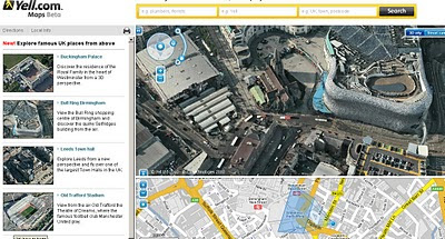
3D Photo-real imagery comes to a few cities in the United Kingdom in Yell Maps Beta.

"In a UK-first, the photo-realistic 3D maps were created from actual film footage shot from light aeroplanes using sophisticated aerospace technology, which is then merged with other film taken from ground level. They can be used for free on the Yell.com website, which is the online version of the Yellow Pages directory. "

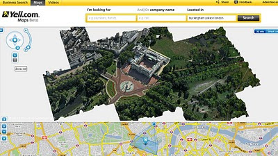
Yell Beta Photo Real 3D Cities UK - Buckingham Palace
Rendering in 3D Buckingham Palace.
Discover the residence of the Royal Family in the heart of Westminster from a 3D perspective.

View the Bull Ring shopping centre of Birmingham and discover the quirky Selfridges building from the air.


Explore Leeds from a new perspective and fly over one of the largest Town Halls in the UK.


View from the air Old Trafford the Theatre of Dreams, where the famous football club Manchester United play.

Full Url to the Birmingham Bullring

Source:
Slashgeo

Labels: , , , , , ,

16 June 2010

Transport for London - Data Released June 2010

Transport for London Data Released June 2010

Transport for London Data Release
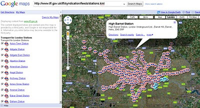
Tube Stations Data (but not up-to-date) in KML format

Data is Available from Here [Feb 2010]
Metadata is Here

Mapped


What is Free?

The London Datastore currently hosts the following travel-related data sets: Via the TfL developer page:

Station Locations

TfL Pier Locations

Live Traffic Cameras

Oyster Ticket Stop Locations

Static files on GLA servers

Cycle Hire Locations

London Underground Signals Passed at Danger

TfL Investment Programme

TfL Business Plan

Riverboat Timetables

The LDS says it is "currently working" on also releasing more datasets by 30 June 2010, including

- Bus Stops

- Bus Routes

- RODS Data (Rolling Origin and Destination Survey Data).

[Note: LIVE FEEDS ARE NOT AVAILABLE signing up required.]

Links to Examples:

http://www.tfl.gov.uk/tfl/businessandpartners/syndication/example-feeds.aspx

Thanks to the Guardian and it's campaign

Labels: , , , , , ,

14 June 2010

ArcGIS 10 - Are You Ready?

ArcGIS 10 - Are You Ready?

Some ESRI users might get a bit of a shock now. ArcGIS 10 is to be released in 14 days
Users with up-to-date maintenance can download it for the first time.
Note: importantant changes to ArcGIS 10 Geodatabases at the bottom of this post.

ESRI to release ArcGIS - June 2010
ESRI to Release ArcGIS 10 by the end of June 2010.

The release date of ArcGIS 10 is announced for 21st June 2010 (ESRI Partners) and 28th June 2010 to everyone else on maintenance.
The 'E' in ESRI (for Environmental) is now acknowledged as ArcGIS will be downloadable.
(2.4 GB for the desktop version)

The bigger shock will be the Minimum Requirements:

Hardware required to drive ArcGIS 10:

CPU Speed 2.2 GHz dual core or higher
Processor Intel Core Duo, Pentium 4 or Xeon Processors

Memory/RAM 2 GB or higher
Display Properties 24 bit color depth
Screen Resolution 1024 x 768 recommended or higher at Normal size (96dpi)
Swap Space Determined by the operating system, 500 MB minimum.
Disk Space 2.4 GB
In addition, up to 50 MB of disk space maybe needed in the Windows System directory (typically C:\Windows\System32). You can view the disk space requirement for each of the 10.0 components in the Setup program.

If using ArcGlobe (as part of 3D Analyst),
additional disk space may be required. ArcGlobe will create cache files when

Video/Graphics Adapter ArcGIS 3D Analyst – ArcGlobe requires a 24-bit capable graphics accelerator

An OpenGL 2.0 or higher compliant video card is required, with at least 128 MB of video memory however 512 MB of video memory or higher is recommended.
Networking Hardware
Simple TCP/IP, Network Card or Microsoft Loopback Adapter is required for the License Manager.

Software Requirements:
.NET Framework 3.5 SP1 must be installed prior to installing ArcGIS Desktop.

Internet Explorer 7+ Some features of ArcGIS Desktop require a minimum installation of Microsoft Internet Explorer Version 7.0 or 8.0. If you do not have an installation of Microsoft Internet Explorer Version 7.0/8.0, you must obtain and install it prior to installing ArcGIS Desktop.

Python Requirement for Geoprocessing:
Several ArcGIS geoprocessing tools, such as Multiple Ring Buffer, use the Python scripting language and require that Python is installed. If the ArcGIS Desktop, Engine or Server setups do not find Python 2.6.2 on the target computer, it will install Python 2.6.2 plus Numerical Python 1.3.0 during a typical or complete installation. You may choose a Custom installation to unselect the Python feature to avoid installing this feature. See the install guide for additional information concerning Python.

Microsoft Vista and Windows 7 WinHelp patch

http://resources.arcgis.com/content/arcgis-desktop-system-requirements#ArcGISDesktop-SoftwareRequirements

Do users need to upgrade Geodatabases?
Yes
, but there are situations where you cannot (clients not on the same platform).

But to get New Features like:
  1. A new utility, Query Layers based on Stand-alone tables or SQL Tables (queries you define are executed each time you use or render the data).
  2. Six New Topology Rules (Polygon: Contains One Point, Line: Must Be Inside etc)
  3. Controlling the storage has changed. [GEOMETRY_OUTOFLINE, BLOB_OUTOFLINE, and GEOMETRY_AND_BLOB_OUTOFLINE]
  4. New Geometric Network Wizard (creates faster geometric networks)
  5. Vertical Lines have z-values (you can have the same x,y in 2 features but each has different z values).
  6. New data types: ST_Raster, New DBTUNE (SDE API), Varbinary(max) (MS SQL server)
  7. New date columns created in ArcSDE geodatabases in SQL Server 2008 use the datetime2 data type. Datetime2 can store dates as early as 01/01/0000, whereas the earliest date you can store with a datetime field is 01/01/1753
  8. ST_Geometry storage type in geodatabases in Oracle and PostgreSQL can now store parametric circles and ellipses.
  9. GEOMETRY_STORAGE parameter can be set to either GEOMETRY or GEOGRAPHY (SQL server)
http://help.arcgis.com/EN/ArcGISDesktop/10.0/help/index.html#/What_s_new_for_geodatabases/00qp0000000v000000/

ArcGIS 10 New Features
http://www.esri.com/software/arcgis/whats-new/new-features.html#f1

So are you really ready? Are you sure?

Labels: , , , , , ,

11 June 2010

World Cup 2010 Maps - South Africa

World Cup 2010 Maps - South Africa

updated 8pm 11th June 2010

With South Africa Opening the World Cup with the first World Cup 2010 GOAL against Mexico here is a quick guide of the best of a selection of World Cup Maps (RSA 1 vs Mexico 1 final score)

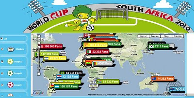
Bing Maps World Cup 2010

Bing Maps World Cup 2010 App

Only just released is a another 'app' from Bing Maps that gives you metadata on teams, fixtures and results on the map and left side panel. Hopefully it will be updated live in real-time.

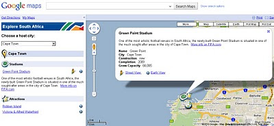
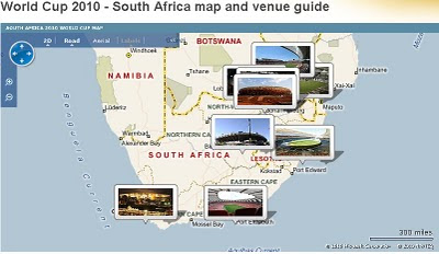
Google Maps World Cup 2010 Cape Town
Google have a dedicated World Cup 2010 Venue Map at
http://maps.google.com/maps?ftr=marketing.worldcup


Mapsize World Cup 2010
Colourful World Cup Map at:
http://worldcup.mapize.com/


Washington Post World Cup Explorer
http://www.washingtonpost.com/wp-srv/sports/worldcup/map/index.html


BBC World Cup Map Bing Maps
BBC have a Venue Map here
http://news.bbc.co.uk/sport/hi/football/8094737.stm & here
http://news.bbc.co.uk/2/hi/in_depth/8726302.stm

An Best Individual Map Award goes to Keir Clarke
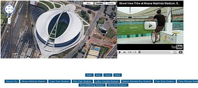
Keir Clarke South Africa Venues World Cup
World Cup Venues
http://homepage.ntlworld.com/keir.clarke/web/wcvenues.htm

Labels: , , , , ,

09 June 2010

Google Android Navigation Expands

Google Android Navigation Expands

Google Maps Navigation version 4.2 is now available in Austria, Belgium, Canada, Denmark, France, Germany, Italy, the Netherlands, Portugal, Spain, and Switzerland
*
for Android devices 1.6+

Google Navigation Coverage Map


Google first added free turn-by-turn voice guidance to its smartphone operating system in October last year. The move has had some lasting effects on the navigation sector. For example, Nokia followed in Google's footsteps and announced free turn-by-turn voice guidance for Ovi Maps in January.

Sources:
http://www.pcworld.com/article/198376/googles_turnbyturn_navigation_comes_to_more_countries.html

http://googlemapsmania.blogspot.com/2010/06/google-maps-navigation-going-global.html
Official Post:
http://googlemobile.blogspot.com/2010/06/fun-on-autobahn-google-maps-navigation.html

Labels: , , , , ,

08 June 2010

South Africa Google Streetview Released

South Africa Google Streetview Released

update: now available at http://maps.google.co.za/
South Africa Google Streetview Released
South African Streetview Coverage

Just in time for the Football World Cup 2010.

But don't forget the scenery like this


Official Post:
http://google-latlong.blogspot.com/2010/06/street-view-brings-taste-of-south.html
View Larger Map

Labels: , , , , , ,

07 June 2010

Bing Maps API 6.3 Released [AJAX] & REST Service

Lots Bing Maps news out this week. MoreBing Maps Apps and A New Bing Maps SDK

But more importantly for the developers who make these mapping applications

So this post covers Bing Maps API 6.3 Released [AJAX]
Bing Maps AJAX New Version 6.3

The new AJAX Control is version 6.3 and has the following changes:

Core functionality version of the map control. The Bing Maps AJAX Control is now available in both full functionality [6.3] and core functionality [light 6.3c] versions. If you do not have advanced mapping needs, you can enhance the performance of your map control application by using the core version of the latest map control. Note the version number (v=6.3c) for the core control which is now a slimmer down to an impressive 35kb. Meaning your maps will load much faster in the web browser.

Replace the Map Control Script to:
http://ecn.dev.virtualearth.net/mapcontrol/mapcontrol.ashx?v=6.3c&mkt=en-us


New Search and Geocode methods.
The new VEMap.Search Method and the VEMap.Geocode Method provide an easier way to return the most accurate search results. The current VE.Find Method has like 11 arguments for making your request more specific. If you know what you want and would rather slim your request down to 3 (query, callback, options).

Sample: (Geocode): map.Geocode(‘1 Microsoft Way, Redmond, WA’, findCallback, options);

Sample: (Search): map.Search(‘Fish Tacos in San Diego’, findCallback, options);

Drag-able Push-pins!
Drag-able pushpins. With the latest version of the Bing Maps AJAX Control, your pushpins become drag-able by simply setting the VEShape.Draggable Property of the pushpin to true. There are also optional events associated with the dragging motion that you can capture and fire off additional events such as search queries or grabbing pixels to convert to lat/lons.

Sample:
var pushpin = null;

pushpin = new VEShape(VEShapeType.Pushpin, map.GetCenter());
pushpin.Draggable = true;
pushpin.onstartdrag = StartDragHandler;

pushpin.ondrag = DragHandler;

pushpin.onenddrag = EndDragHandler


Good stuff for Bing Maps Platform developers! hope to see some cool applications coming from these new APIs.#Bing Map Apps API that was also released today. The Bing Map Apps API allows you to submit your Silverlight application to be published on Bing Maps.

New Bing Maps REST Service: (now with example requests and responses)

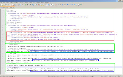
"This was in addition to the Bing Maps SOAP Service (via Windows Communication Foundation) and the AJAX Control that have been in use for years now. Today, we’re announcing a REST interface into those wonderful maps, aerial images, and geocoding and routing systems for your grubby coding hands to get all dirty. And, the beauty with REST is that you simply need to build URL queries and handle the JSON or XML responses."
Bing Maps AJAX New Version 6.3 - REST Geocoding XML etc
Click for a bigger version: Geocoding by XML, PIPE|, TAB and CSV responses from BING Maps using REST method.
Blue and Red represent the actual geo-info you are after to plot markers on a map
Source:
http://msdn.microsoft.com/en-us/library/ff701732%28v=MSDN.10%29.aspx

http://www.bing.com/community/blogs/maps/archive/2010/06/07/rest-easy-bing-maps-has-you-covered.aspx


Links:
http://www.microsoft.com/maps/isdk/ajax/ not updated to 6.3 yet.
http://www.bing.com/community/blogs/maps/ 4 Bing Maps related posts:
New Developer Forum
http://www.bing.com/community/forums/12283.aspx not much here yet.

Labels: , , , , , ,

04 June 2010

Historypin - Streetview with History

Historypin - Streetview with History
*
Historypin was built with Google and they provided invaluable support throughout the process.

update: Nice introduction to HistoryPin with this video.


"Historypin is a online tool that acts as a digital time machine, allowing people to view and share history in a totally new way."

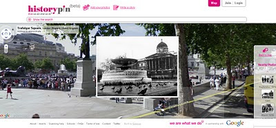
Historypin beta - Streetview with History
Sharing Past memories and important events with Google Streetview and Historical Photography display correctly in 4D space.

"Historypin invites the public to dig out, upload and pin their own old photos, as well as the stories behind them, onto the Historypin map. Uniquely, Historypin allows users to layer their old images onto modern Street View scenes, revealing a series of windows into the past."
http://www.wearewhatwedo.org/generations/

Interactive Timeline
One of the most useful tools for finding historical photographs is the interactive timeline that can span as far back as 1840's.

Historypin beta - Streetview with TimeLine Slider
Use the time-line interactive slider to find more recent or past photographs whilst in the map/streetview mode.
Using Google Maps and Street View technology, Historypin aims to become the largest user-generated archive of the world’s historical images and stories.

The site invites the public to dig out, upload and pin their own old photos, as well as the stories behind them, onto the Historypin map. Uniquely, Historypin allows users to layer their old images onto modern Street View scenes, revealing a series of windows into the past.


Trafalgar Square, London.
http://www.historypin.com/photos/search/streetview/1/radius/969778/bounds/56.523139564372194,9.99755859375,50.90303283111257,-18.12744140625/zoom/0/geo/53.800651,-4.064941/date_from/1840-1-1/date_to/2010-6-3/yaw/292.37/pitch/5.95

same link in human terms: http://tinyurl.com/historypin-trafalgar-sq

More information:
http://googlemapsmania.blogspot.com/2010/06/largest-archive-of-photos-on-google.html

Main website: http://www.historypin.com/

Go straight to the Map - http://www.historypin.com/photos/


Creators -
http://www.wearewhatwedo.org/

Labels: , , , , ,

02 June 2010

Map Open Data with Google Fusion Tables

Map Open Data with Google Fusion Tables

With all the Open Data coming online is it easy to take for granted what can be done with it.
But the fact is a file that holds location-al information is great but even better with a map.

Example
Warkwickshire Bridges Map Fusion data
Presentation of the Bridge Height data from Warwickshire County Council in a visual map shows a much more valuable way to deliver the information. proving that the information behind the markers is more important.

source data:
http://opendata.warwickshire.gov.uk/datasets/bridge-height-restrictions

(xls file saved as a csv and uploaded to fusion tables)

Note: Easting and Northings [UK Grid Reference]- quick conversion to latitude and longitude with a slight offset.
Offsetting the marker makes it easier for the user to identify the location of the bridge in this case.

Warkwickshire Bridges Map Fusion Table data

load into google fusion tables
http://tables.googlelabs.com/DataSource?snapid=57803

map
http://tables.googlelabs.com/DataSource?snapid=57802

Then the final Map is just wrapped
in an iframe an offset has been included with bridge locations
done so not to obscure marker data and table information

Final map Zoom in and select Satellite MapType to see the offset markers next to the bridge
http://mapperz.110mb.com/GMAP/warkwickshire_bridges.html

Important Note to Local Authorities
would be good if all the county/metropolitan councils could get this data ready like this!

Labels: , , , , , , ,