->

02 May 2011

ArcGIS 10 Service Pack 2 Released

ArcGIS 10 Service Pack 2

Issues addressed:
http://downloads2.esri.com/support/downloads/other_/ArcGIS-10sp2-issues.htm
ArcGISDesktop10sp2.msp
364 MB

(required)
ArcGISLicenseManager10sp2.msp
13 MB

http://resources.arcgis.com/content/patches-and-service-packs?fa=viewPatch&PID=17&MetaID=1752


Top picks of issues
NIM063852 - The service pack information does not appear in the help about box

NIM064990 - The first 2 links in the Help; About on Windows 7 only, do not work. The 3rd one does.

NIM058951 - ArcMap and ArcCatalog crash when trying to open a particular DGN V8 file.

NIM061452 - Spatial reference along with the units is not read correctly for TIFF images

NIM059249 - ArcMap crashes in an edit session when clicking the layer name in the Attributes window

NIM064252 - Add Rule To Topology tool and Remove Rule From Topology tool needs entries for new rules added at ArcGIS 10

NIM064497 - For maps that contain view extents not present in the spatial ref's extent, ArcMap hangs or crashes when exporting to PDF with the Export Map Georeference Information checkbox turned on.

NIM064458 - Cartographic line symbology with a negative offset causes ArcMap and ArcCatalog to crash when at a large scale.

Full list
http://downloads2.esri.com/support/downloads/other_/ArcGIS-10sp2-issues.htm

Labels: , ,

12 November 2010

ArcGIS 10 Service Pack 1

ArcGIS 10 (Desktop, Engine, Server) Service Pack 1

ESRI recommends that all ArcGIS 10 customers download and install Service Pack 1 at their earliest convenience, to ensure the highest quality experience when working with ArcGIS 10.

NOTE: If you are using a localized version of ArcGIS (other than Simplified Chinese, Japanese, German, French and Spanish), please contact your local distributor to get the updated language supplement.


ArcGIS Desktop (ArcInfo, ArcEditor, ArcView, ArcGIS Eval Edition)
ArcGISDesktop10sp1.msp
361 MB
ArcGIS License Manager
ArcGISLicenseManager10sp1.msp
5 MB
ArcObjects SDK for the Microsoft .NET Framework
ArcObjectsSDKNET10sp1.msp
264 KB
ArcObjects SDK for Cross Platform C++
ArcReader10sp1.msp
76 MB
ArcGIS Engine Runtime
ArcGISEngine10sp1.msp
105 MB
ArcGIS Server for the Java Platform
ArcGISServerJava10sp1.msp
111 MB
ArcGIS Server for the .Net FrameworkArcGIS Server - GIS Services
ArcGISServerGISServices10sp1.msp
85 MB
ArcGIS Server - Web Applications
ArcGISServerWebApplications10sp1.msp
26 MB
ArcGIS Server Web ADF Runtime

Labels: , ,

28 June 2010

Download ESRI ArcGIS 10 - Released

Download ESRI ArcGIS 10 - Released

Finally ArcGIS 10 has put the 'E' back in Environmental Systems Research Institute

updated: 21:38 BST 28th June 2010.

Read the Requirements before thinking of downloading

"ESRI (UK) is pleased to announce that ArcGIS® 10 will be available shortly. ArcGIS 10 will revolutionise how organisations use geographical data and delivers a host of new possibilities."

"The ArcGIS 10 software will be available as a download from week commencing 28 June or on DVD at a later date." [But when?]

Users with a maintenance plan can download the software (3.2GB +8.0GB for ArcGIS 10 Data)ESRI ArcGIS 10 Released - Downloadable

ESRI UK has re-vamped their site to include ArcGIS 10 (not just re-directing to the US site)

Here are the links (note: don't try downloading whilst viewing videos unless have a super-fast broadband connection)

ArcGIS 10 Demos:

Introduction to ArcGIS 10
Usability Enhancements (10 usability enhancements in ArcGIS Desktop)
3D in ArcGIS 10 (display, analyze, and maintain 3D data in ArcGIS 10)
Enhanced Map Editing (enhanced map editing tools and workflows)
Modeling and Analysis (more productive, access data faster, and generate better models and results)
Mapping Workflows ( create, manage, and share your maps more efficiently)
Production and Automation (Python window in ArcGIS 10 MapBook, Sharing)

UK Users of UK Specific Products

UK Product Compatibility Status

ProductCompatibility Date
ProductivitySuiteJuly 2010
CrimeAnalystAugust 2010
LocalView FusionAugust 2010
LocatorHubSeptember 2010
http://www.esriuk.com/arcgis10/existing_customers.asp
Full Product list

Please note the web browsers below are supported for the ESRI Customer Care Portal from which our customers will download ArcGIS 10
Internet Explorer: version 6+
FireFox: all versions
Chrome: all versions
Safari: all versions
Opera: 9+
Additionally users will need Flash Player 9+ installed and JavaScript enabled to use the site.

FILE SIZES - BIG
Product LineProducts Available for DownloadFile Size (approximate)
ArcGIS DesktopArcGIS Desktop 103.2 GB

ArcReader 101.6 GB

ArcGIS Desktop Tutorial Data 102.0 GB

ESRI Data & Maps for ArcGIS 108.0 GB


ArcGIS Server EnterpriseArcGIS Server Enterprise 10 for Windows3.0 GB

ArcGIS Server Enterprise 10 for Red Hat Linux Enterprise and SUSE Linux Enterprise3.2 GB

ArcGIS Server Enterprise 10 for Sun Solaris on SPARC3.2 GB

ArcSDE 10 for Windows1.0 GB

ArcSDE 10 for UNIX2.5 GB

ESRI Data & Maps for ArcGIS 108.0 GB

ESRI Data & Maps for ArcGIS Server 108.0 GB


ArcGIS Server WorkgroupArcGIS Server Workgroup 103.5 GB


ArcGIS Engine Developer KitArcGIS Engine Developer Kit 10 for Windows2.6 GB

ArcGIS Engine Developer Kit 10 for Red Hat Linux Enterprise and SUSE Linux Enterprise and Sun Solaris on SPARC2.75 GB

ArcGIS Engine Runtime 102.6 GB


ArcGIS Engine RuntimeArcGIS Engine Runtime 102.6 GB


ArcIMSArcIMS 103.4 GB

ArcIMS Gazetteer0.65 GB


ArcInfo WorkstationArcInfo Workstation 10 for Windows & Sun Solaris on SPARC1.9 GB


ArcGIS Image ServerArcGIS Image Server 100.50 GB


ArcGIS Workflow ManagerArcGIS Workflow Manager 100.07 GB


ArcGIS Server Workflow ManagerArcGIS Server Workflow Manager 100.08 GB


ESRI Mapping and Charting SolutionsESRI Production Mapping 100.25 GB

ESRI Aeronautical Solution 100.35 GB

ESRI Defense Mapping 100.40 GB

ESRI Nautical Solution 100.35 GB


ArcGIS Data ReviewerArcGIS Data Reviewer 100.10 GB


Tracking ServerTracking Server 100.50 GB


ArcPadArcPad 100.20 GB

ESRI StreetMap Premium Tele Atlas North America (USA and Canada)2.0 GB

ESRI StreetMap Premium Tele Atlas Europe3.0 GB
US Site:

Labels: , , , , ,

14 June 2010

ArcGIS 10 - Are You Ready?

ArcGIS 10 - Are You Ready?

Some ESRI users might get a bit of a shock now. ArcGIS 10 is to be released in 14 days
Users with up-to-date maintenance can download it for the first time.
Note: importantant changes to ArcGIS 10 Geodatabases at the bottom of this post.

ESRI to release ArcGIS - June 2010
ESRI to Release ArcGIS 10 by the end of June 2010.

The release date of ArcGIS 10 is announced for 21st June 2010 (ESRI Partners) and 28th June 2010 to everyone else on maintenance.
The 'E' in ESRI (for Environmental) is now acknowledged as ArcGIS will be downloadable.
(2.4 GB for the desktop version)

The bigger shock will be the Minimum Requirements:

Hardware required to drive ArcGIS 10:

CPU Speed 2.2 GHz dual core or higher
Processor Intel Core Duo, Pentium 4 or Xeon Processors

Memory/RAM 2 GB or higher
Display Properties 24 bit color depth
Screen Resolution 1024 x 768 recommended or higher at Normal size (96dpi)
Swap Space Determined by the operating system, 500 MB minimum.
Disk Space 2.4 GB
In addition, up to 50 MB of disk space maybe needed in the Windows System directory (typically C:\Windows\System32). You can view the disk space requirement for each of the 10.0 components in the Setup program.

If using ArcGlobe (as part of 3D Analyst),
additional disk space may be required. ArcGlobe will create cache files when

Video/Graphics Adapter ArcGIS 3D Analyst – ArcGlobe requires a 24-bit capable graphics accelerator

An OpenGL 2.0 or higher compliant video card is required, with at least 128 MB of video memory however 512 MB of video memory or higher is recommended.
Networking Hardware
Simple TCP/IP, Network Card or Microsoft Loopback Adapter is required for the License Manager.

Software Requirements:
.NET Framework 3.5 SP1 must be installed prior to installing ArcGIS Desktop.

Internet Explorer 7+ Some features of ArcGIS Desktop require a minimum installation of Microsoft Internet Explorer Version 7.0 or 8.0. If you do not have an installation of Microsoft Internet Explorer Version 7.0/8.0, you must obtain and install it prior to installing ArcGIS Desktop.

Python Requirement for Geoprocessing:
Several ArcGIS geoprocessing tools, such as Multiple Ring Buffer, use the Python scripting language and require that Python is installed. If the ArcGIS Desktop, Engine or Server setups do not find Python 2.6.2 on the target computer, it will install Python 2.6.2 plus Numerical Python 1.3.0 during a typical or complete installation. You may choose a Custom installation to unselect the Python feature to avoid installing this feature. See the install guide for additional information concerning Python.

Microsoft Vista and Windows 7 WinHelp patch

http://resources.arcgis.com/content/arcgis-desktop-system-requirements#ArcGISDesktop-SoftwareRequirements

Do users need to upgrade Geodatabases?
Yes
, but there are situations where you cannot (clients not on the same platform).

But to get New Features like:
  1. A new utility, Query Layers based on Stand-alone tables or SQL Tables (queries you define are executed each time you use or render the data).
  2. Six New Topology Rules (Polygon: Contains One Point, Line: Must Be Inside etc)
  3. Controlling the storage has changed. [GEOMETRY_OUTOFLINE, BLOB_OUTOFLINE, and GEOMETRY_AND_BLOB_OUTOFLINE]
  4. New Geometric Network Wizard (creates faster geometric networks)
  5. Vertical Lines have z-values (you can have the same x,y in 2 features but each has different z values).
  6. New data types: ST_Raster, New DBTUNE (SDE API), Varbinary(max) (MS SQL server)
  7. New date columns created in ArcSDE geodatabases in SQL Server 2008 use the datetime2 data type. Datetime2 can store dates as early as 01/01/0000, whereas the earliest date you can store with a datetime field is 01/01/1753
  8. ST_Geometry storage type in geodatabases in Oracle and PostgreSQL can now store parametric circles and ellipses.
  9. GEOMETRY_STORAGE parameter can be set to either GEOMETRY or GEOGRAPHY (SQL server)
http://help.arcgis.com/EN/ArcGISDesktop/10.0/help/index.html#/What_s_new_for_geodatabases/00qp0000000v000000/

ArcGIS 10 New Features
http://www.esri.com/software/arcgis/whats-new/new-features.html#f1

So are you really ready? Are you sure?

Labels: , , , , , ,

03 April 2010

ESRI Resource Centre - New

ESRI Resource Centre - New
or Center

ArcGIS 10 resource centre open

http://resources.arcgis.com/

ArcGIS 1o products included (intentionally?)

ArcGIS 10 includes a redesign of the ArcGIS Desktop interface and additional and improved functionality throughout the ArcGIS product line.

The following sections summarize changes in the software in different functional areas. Each section includes links to topics with more information for that specific area of the software.

Documentation

The resource centers and Support Web sites are merged into a single Web site and user experience.

Product documentation is reorganized and improved.

  • Over 75 percent of the help has been rewritten and updated.
  • Topics have been organized based on skill sets. The Essentials library contains core GIS concepts. The Professional library contains information about software functionality, how to use it, and more advanced GIS concepts.
  • The Administrator library contains information for people who install software, manage licensing, and administer servers and databases. The Developer library contains information for people who want to customize ArcGIS, create their own custom applications, or access data outside of ArcGIS clients.
  • Workflows and tutorials have been added to the ArcGIS installed and Web help.
  • The installed help files take up less space on your computer.
  • Videos have been added to the Web help.
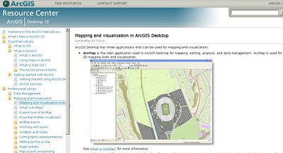
example :
Mapping and visualization in ArcGIS Desktop

http://help.arcgis.com/en/arcgisdesktop/10.0/help/index.html# /Mapping_and_visualization_in_ArcGIS_Desktop/00660000042t000000/

Deeper Examples:
Exercise 1: Learning the fundamentals of representations
http://help.arcgis.com/en/arcgisdesktop/10.0/help/index.html#/Exercise_1_Learning_the_fundamentals_of_representations/008t00000073000000/

source:
http://geo.geek.nz/esri/redesigned-esri-support-centre-website-now-available/

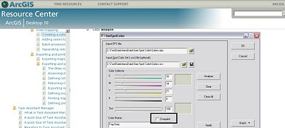
and a surprise Overprinting is now supported!
(after 8 years of asking)

Spot Tool overprinting

ArcGIS 10 supports overprinting via the Spot Color tool. This allows you to create color-mapped .eps files for a series of map sheets that use the same set of colours.

Labels: , , , , , , ,