->

30 January 2008

Nokia Beta Labs - Location Tagger

Nokia Location Tagger
(georeferencing your phone camera photos)

Nokia Location Tagger

"What is it all about? Nokia Location Tagger is a small application running on “selected” S60 3rd devices that allows you to tag pictures captured from Camera application with geographical coordinates from GPS. The tagging process itself is sometimes called geotagging or geocoding (see also this article at Wikipedia). Technically, the location information is stored in the EXIF header of your pictures (.jpg file)."

Nokia Location Tagger S60


With Nokia Location Tagger, you can automatically tag your location data to your pictures. As you take a picture, your GPS coordinates are saved to the EXIF header of the JPEG file. You can use this data later, for example, to locate your pictures on a map.
In the near future, we hope to make location tagging a seamlessly integrated part of your Nokia experience. Until then, Nokia Location Tagger is a small standalone application that gives you a sneak preview. We are not planning to productize this application as such, but we’d love to hear your thoughts already now, so that we have time to take it into account in the mainstream development.
Tested with Nokia N95, N95 8GB, N82, and E90 using the integrated GPS. Should work but not fully tested with all S60 3rd edition devices using an external Bluetooth GPS receiver. Sharing your location-tagged pictures online requires Share Online 3.0.

- Launch Nokia Location Tagger application.- On the main screen, you will see the status of your GPS module. It will show the coordinate if GPS module is active. Otherwise, it will show "Searching".- To tag pictures with GPS coordinates, simply use the built-in Camera application. Press the Camera button of your device to take pictures as usual. When Nokia Location Tagger is running in the background, you will see small icon at the top left corner of Camera’s view finder. This indicates the status of GPS module: Green: GPS module is active. Amber: Nokia Location Tagger is connecting to GPS module or searching for GPS coordinate. Red: GPS module is inactive.

Q: What happens if I take pictures while the GPS module is not active yet?

A: Nokia Location Tagger tries to tag pictures to the last "known" coordinates in the last 10 minutes. Since GPS module normally takes some time to initialize, it’s better to launch Camera application a couple of seconds before taking pictures. Launching Camera application will activate Nokia Location Tagger; which will initialize GPS module. You can also bring Nokia Location Tagger window to the foreground to initialize GPS module.


Q: Will my battery be empty very fast when running Nokia Location Tagger in the background?A: Nokia Location Tagger has a time-out feature (by default, it is 5 minutes). If there is no picture until time-out time, the GPS module will be turned off. This will normally save power. you can change the time-out option in the settings (2, 5 (default), or 10 minutes)

Q: How can I view the GPS coordinates of my pictures?A: The GPS coordinates are stored in the EXIF header of JPEG files. Some online sites, such as Flickr and Panoramio are able to display GPS coordinate from the EXIF. For more info on these services, please see below. You can also use photo organized software that read EXIF, such as Picasa (with the combination of Google Earth).
Q: How can I set Flickr to automatically import location in my uploaded pictures, and place them on a map accordingly?A: Please go to this URL: http://www.flickr.com/account/geo/exif, sign in, tick the yes please box and click save. From now on, all new tagged pictures that you upload will automatically be placed on a map. Also underneath every picture, there will be a map link that - after you click on it - shows where the picture is taken. Here are some examples. A nice alternative to Flickr is Panoramio. After uploading your pictures, you can view them on Google Maps but also export them to Google Earth. Here are some examples.
issues- The pictures from secondary camera are not tagged. Nokia Location Tagger tags pictures from the main camera only.- In a very rare case, Nokia Location Tagger may not be able to tag picture with the error message "File is being used".- Pictures captured in burst mode may not be displayed in order in the Logs tab.- This version has been tested on N95, N82, E90 as well as N73, N81 with external GPS module (Nokia LD-4W). It should work on all other devices; but there is no guarantee at this point.

What can we do with the Geo-tagged pictures? You can upload them to the photo sharing sites, such as Flickr, Panoramio and Picasa Web, so that your friends know where the pictures were taken. If you want to keep them private on your PC, some photo organizer applications, such as Picasa (combined with Google Earth), are able to display location information.
Please read the instructions at Nokia Location Tagger web page.

Labels: , , , , , ,

28 January 2008

London Maps gets SuperZoom - 192.com

London Maps gets SuperZoom - 192.com

update: 28/01/2008
Full Screen Beta Version
of SuperZoom


(aerial photography at a resolution of 4cm for London)

192.com Maps Super Zoom London


"See 280 square miles of London in amazing aerial photography, from Parliament Hill to Dartford, Tooting to Upminster"


192.com Maps Super Zoom Nelsons Column Trafalgar Square
Images are very high resolution but concerns over privacy.

**The west of London is unavailable because of flight restrictions around Heathrow.

More details and privacy concerns raised here Guardian Technology

12.5cm Aerial Photography is available for the rest of the UK on
http://www.192.com/maps/


Labels: , , , ,

Did you mean? Google Maps

Did you mean? Google Maps

Did You Mean? Yellow Markers Points of Interest
New yellow markers indexed to the sidebar help narrow down places of interest.
You can also get directions to each one.
Lots of 'GIS' going on underneath to do this.


Now you can find points of interest and do not need to have an end address/location to get map directions.
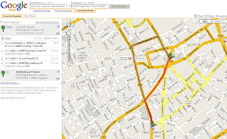
Click for route - but walking might be quicker
Driving Directions? But sometimes quicker to walk.
(red line would be shortest route to walk and still uses Teleatlas data)
**red line added by mapperz

Suggestion:
Would be handy in large cities to have a 'walk to' option as you can see in Leicester Square you get sent around the one way system. But Leicester Squaree is pedestrian only and would take only a few minutes to walk.
If driving you might miss the show.

based on the post
http://google-latlong.blogspot.com/2008/01/no-address-required.html

Labels: , , , ,

25 January 2008

The Mole Map UK

The Mole Map UK

"The map below shows a selection of the sightings that have been recorded. Click on a molehill to find out who spotted what!"

The Mole Map UK

"The mole is thought to be one of the most common mammals here in the UK, however there is very little basic information about them and their numbers. With continuing changes to our countryside it is important to monitor species that can be affected by farming methods and the fragmentation of their habitat, before something happens and it is too late to help. Currently there is no detailed map for moles in the UK, so we have decided to carry out MoleWatch, to find out more about these secretive creatures"
http://www.ptes.org/molewatch/about.html

currently 27,040 moles and counting...

The Mole Map

"A group of moles is called a labour."
(you learnt something today)

See or seen a mole or labour of moles? in the UK - sign in here http://www.ptes.org/molewatch/survey-form-1.html


Labels: , , ,

23 January 2008

The Weather Cam Map (UK)

The Weather Cam Map (UK)

Weather Cam MapWeather Cam Map Accuracy
Webcams show you the weather live - Coloured Polygons show you an accuracy ratio

  • Nice clean map
  • Easy to use and update
  • Informative and up-to-date
Note:
This is not intended to show how weather forecasting can be inaccurate, but more to show which areas are served well by a general weather forecast.

Map created by beats! design

Suggestions?
Maybe a georss overlay from the Met Office?
(as google maps api supports georss)

Example is BlueGhost UK Weather

Labels: , , , , ,

21 January 2008

Google Transit Map UK

Google Transit Map UK - Real-Time Transit Information
Google Transit Maps UK
Nothing new but a UK first, data from Traveline Southeast
for the Map above

Shame Transport for London (TfL) cannot make use of this.
They have the feeds (rss based) now.
Automatic Geocoding has undesired results (some outside the UK)

There is good coverage particularly in California, US
see more transit areas
http://maps.google.com/transit

Why only the South East?
It's all down to sources, currently only Travel Line have there data in the correct format for Google to read and be able to map it.
It's early days for this in the UK, hopefully National Rail and Transport for London & others start providing this information for third parties such as Google.
try:
http://googleblog.blogspot.com/2008/01/public-transit-made-easy.html


Transit Feed Specification is available here
http://code.google.com/transit/spec/transit_feed_specification.html
hopefully this blog gets read by the companies to make it happen.
Again there will be copyright and legal issues on what can be done with the data


Labels: , , , , ,

17 January 2008

Airliner crash lands at Heathrow (Map)


View Larger Map
A quick map of news - based on news information (BBC Sourced) - only an approximate location

"The incident happened as Prime Minister Gordon Brown was due to leave Heathrow for China and India. His flight was delayed because of the incident. "

"All 136 passengers and 16 crew escaped from the British Airways flight BA038 from Beijing. Six people have been taken to hospital with minor injuries.

An airport worker told the BBC that the pilot said he had lost all power and had to glide the plane into land. "


More information on the BBC News Website

Sky News also have good coverage (pics)

Labels: , , , , , ,

15 January 2008

MSN Map Search in China

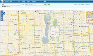
MSN Map Search in China

Detailed Searching now available in China

Mapping at street level with local search terms

"MSN today launched its latest online map search in China. Based on Microsoft’s virtual earth platform, the new service will include detailed information on 114 cities in China, including information on the public transit system in 11 cities. MSN China had launched its online map service in China prior to Baidu and Google both launching their own map services."

source:RedlineChina

Maps at:
http://ditu.live.com/

Labels: , , ,

11 January 2008

OpenStreetMap Nestoria (Experimental)

OpenStreetMap Nestoria (Experimental)

Nestoria are looking and experimenting with the OpenStreetMap Data and making some very clever and useful additional usability to finding property (to buy, rent or flatshare). In the UK or Spain

Nestoria Openstreet Map Experiment
With the drop down (more search options) you can be more specific
options:
  • Balcony
  • Basement
  • Dishwasher
  • Fireplace
  • Furnished
  • Garage
  • Garden
  • High Ceilings
  • Lower Ground
  • Parking
  • Wood Floor
Census information can also be applied and helps locate nearby services.

The Mapping Data does vary in places but it is very good to see that this being used and work very well.

Nestoria also have an API for Developers:
http://www.nestoria.co.uk/help/api

Open Street Map is moving on, lots more data is going in. (09-Jan-2008 20:57 3.1GB)
compared to 2.1GB only a month ago (05-Dec-2007 09:42)
http://planet.openstreetmap.org/

Where is all this new data coming from?
Well the OSM servers are flying as at noted the entire Tiger dataset was getting imported

The entire US will be done in: 1499766 seconds or 17 days or 0.047525 years on Monday January 28th at 17:26:08 2008.
(previous blog post noted Sun Aug 24 12:27:57 2008 as the finish date)


Also in discussion is the "The licence: where we are, where we’re going"
http://www.opengeodata.org/?p=262

Mapperz gives full credit to Nestoria and Open Street Map - People outside the UK don't really understand the expense and difficult/complex data licensing that Ordnance Survey produces.
(but it can afford to build a brand new HQ)
*wonder if their government ceramic discs will go missing in the move?

Labels: , , , , , , , ,

10 January 2008

New Nuclear Plants Get Go-ahead - KML Map

New nuclear plants get go-ahead
from the BBC News Top Story
http://news.bbc.co.uk/1/hi/uk_politics/7179579.stm

Nuclear UK Development Plans
Image Source: BBC News/Jackson Consulting & DTi


To Location Map in Google Maps with link to the Wikipedia for each site.


View Larger Map

Thanks to Mike Williams (HTML in KML assistance)

Labels: , , , , ,

09 January 2008

Sam Knows Broadband - New Mapping Engine

Sam Knows Broadband - New Mapping Engine

Sam Knows is one of the best independent sites for finding broadband (Phone or Cable) in the United Kingdom. Now their Mapping Application is even easier use.


The 'Old' Mapping required both Telephone (BT) Number and Postcode to find out broadband availability. Now you do not need these.

Sam Knows Broadband UK - Mapping
Reverse Geocoding aids the location search for broadband services in any area of the UK.
Purple Transparent Polygon shows the approximate area of broadband coverage for a BT Exchange.
Try it out here:
http://www.samknows.com/broadband/mapping/mapping.php

The mapping system is designed to be as easy to use as possible. If you just want to browse around your area to see what telephone exchanges are nearby and what services they provide, then simply enter the name of your area in the search box and click Search. You can then zoom in, zoom out or move around the map (by clicking and dragging with your mouse).

Exchanges will appear as blue buildings on the map and will appear dynamically as you move around. You can click on any exchange to see a summary of the wholesale services at the exchange (e.g. the ADSL, SDSL, LLU and cable services in the area).

The Map 'Side Panel' records and shows you more information on the exchange and shows a list of broadband providers with a good approximate maximum speed of broadband
for that location

If you're looking to move home or are just interested in your own area, then the mapping system has something for you too. Click on any road or place on the map to receive useful information including the connected telephone exchange and the distance from it in metres. There's also an option here to perform a broadband availability check.

The new mapping engine makes extensive use of the existing database we have and couples it closely with the Google Maps API, which provides the postcode and address lookup functionality. A special thank you goes to Nico for his Reverse Geocoder addon for the Google Maps API (Click here for more).
Mapperz update - Nico has version
1.0.5 out now:
http://nicogoeminne.googlepages.com/full5.html
"
I added a helper function to search the resulting placemark for a certain property."

The availability checks offer a significant improvement over the existing postcode-level checks in use by sam knows and others. These new checks are premise-level for all ADSL based services and Virgin Media's cable services. The estimated speed for ADSL broadband services is derived directly from BT Wholesale's checker systems. Note that the ADSL2+ speed estimates are derived from the distance from the exchange and the ADSL speed attainable, correlated against the Internode graph

The exchange coverage polygons are derived from known postcodes served by the exchanges (captured from historical checks performed on the existing availability checker). Sampling well over a million such records and combining it the data with Google's geocoding engine has enabled us to produce the polygons. Note that these are likely to be erroneous in some instances, primarily due to a postcode being incorrectly tagged to an exchange. Such errors will be cleared up over time.

Samknows.com is dedicated to tracking the roll-out and progress of broadband across the UK. It was created by Sam Crawford, and is also maintained by Paul Buck and Ian Saunders.

"The site was started as a small hobbyist site after I worked at Datasouth UK on the Hampshire Broadband project. I left there in September 2003 to study for a BSc Hons in Computer Science at the University of Bath. Four years on and I have now graduated with a first-class degree, and will be returning to Canary Wharf this autumn to work as a developer of mobile computing applications."


Well done Sam and the Team.
Nico Reverse Geocoder was blog about here first.
http://mapperz.blogspot.com/2007/08/exclusive-reverse-geocoding-using.html
http://mapperz.blogspot.com/2007/11/google-reverse-geocoder-update.html
Nice to see that it is getting used in full.


Labels: , , , , , , ,

08 January 2008

Yahoo! Go 3.0 (Beta) with Maps

Yahoo! Go 3.0 (Beta) with Maps

Yahoo Go 3.0 Beta


Yahoo! Go 3.0 services:

  • oneSearch
  • Yahoo! Calendar
  • Yahoo! Address Book
  • Yahoo! Local
  • Yahoo! Maps
  • Yahoo! News
  • Yahoo! Sports
  • Yahoo! Finance
  • Yahoo! Entertainment
  • Yahoo! Weather
  • Flickr
  • Yahoo! Mail

"Yahoo! Go 3.0 connects your device to these Yahoo! services in real time. You can manage your contacts on the device and changes are synchronized with your Yahoo! account. The application uses widgets to display information from your Yahoo! services. Download provides a basic set of Yahoo! Go 3.0"

Yahoo Go 3.0 Map Search

Local & Maps searches for and provides information and images specific to a location or business. The results of the search show up on the display as a

map with pinpoint links to a list of items including:
  • web sites
  • mobile-friendly web sites
  • businesses with addresses, telephone numbers, driving directions, maps, and ratings and reviews

Results will vary based on what you search for and the location set. Local & Maps remembers the last location mapped so that you can get the information again immediately.

Other ways to get information relevant to a location are listed at the Local & Maps position of the carousel:

  • Map View for the location at the top of the display
  • City guide about places to eat, drink, stay, visit, shop and more
  • Find nearby... with lists of categorized goods and services
  • Driving directions for turn-by-turn instructions for getting from A to B
  • Traffic Watch where you can check traffic incidents for your location and for special routes you define.

*Local & Maps is only available in versions for the United States of America currently.

If your device has GPS, you can use it with Local & Maps.

related links:
http://beta.m.yahoo.com/

http://mobile.yahoo.com/local
(opening 9am PST/5pm GMT 08/01/2008)

Supported phone/device list
http://mobile.yahoo.com/go/phones;_ylt=Ai3Qyh0abqfrpE_8BfnHMAFltQcJ
(N82...?)

See the Tour
http://mobile.yahoo.com/go/tour

Labels: , , , , , ,

07 January 2008

UK and Ireland Flight Maps (Google Earth)

UK and Ireland Flight Maps (Google Earth)

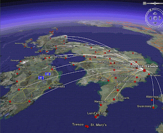
UK Flights from London Gatwick - Click for Animation

Created by http://www.barnabu.co.uk/
KML file available:
http://www.barnabu.co.uk/uk-and-ireland-flight-maps/

"The Placemark balloons include information about airlines and destinations.
Labels follow Wikipedia’s convention of using place names rather than real airport names.
Routes are displayed with exaggerated altitude. "


Guidelines:
"One downside of Google Earth’s highlight mode is it doesn’t stay switched on a after a mouse click. However, there are a few navigation tricks that allow you to keep routes displayed and move around."

  • Click the middle mouse button on an airport icon, and hold it down while moving the the mouse.
  • Hover the mouse pointer over an icon, then switch to keyboard control (cursor keys, shift + cursor keys, Page up/down, + key, - key, etc…).
  • Click on an airport icon, quickly drag it and let go. Just as you would to set the Earth rotating.

Data source:
"The source data for all this is scraped from the Airport pages on Wikipedia, and compiled using a lot of Perl scripting to scrape, mash and meld it into KML. Obviously its never going to be 100% reliable, but at least it should be pretty easy to keep the file regularly updated, and expand to other parts of the world."

Nice use of Wikipages and Google Earth.
Mapperz

Labels: , , , , , ,

04 January 2008

Graphics and Shapes Extension for ArcGIS

Graphics and Shapes Extension for ArcGIS 9.2

11/08/2008
A few extra functions have been added:
  • Added “Build Polygon” function
  • Added Polyline Azimuth options to “Calculate Geometry” tool.
  • Multiple minor edits to code and manual, described in full in manual.
  • Build 1.1.76 (January 10, 2008) Corrects a bug where the Spheroidal Length was being written to the wrong field.
version 1.1.76
http://arcscripts.esri.com/details.asp?dbid=15376

"Description: This extension includes a large suite of tools for calculating geometric attributes of vector features and for selecting and naming graphics. All tools are available at the ArcView license level."

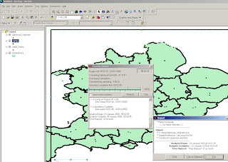
Jeff Jenness Graphics Shape Tools for ArcGIS Results
Cleaner and Faster than conventional 'ESRI' Toolsets (and a progress bar that works)


Jeff Jenness Graphics Shape Tools for ArcGIS
Simple layout of functions - much better than those geoprocessing tools in the toolbox you can never find the name for.

Tools for Graphics
Graphic Elements to Shapes
Select Graphic Elements by Type
Select All Graphic Elements
Unselect All Graphic Elements
Flip Graphic Element Selection
Zoom to Selected Graphic Elements
Name Graphic Elements
Tools for Shapes
Convert Polygons to Label Points
Convert Shapes to Centroids
Convert Shapes to Spherical Centroids (detailed method explained in PDF)
Convert Shapes to Vertices
Convert Polylines to Polygons
Convert Polygons to Polylines
Split Multipart Features
Combine Features
Calculate Geometry


"Jeff Jenness is an independent GIS consultant specializing in developing analytical applications for a wide variety of topics, although he most enjoys ecological and wildlife-related projects. He spent 16 years as a wildlife biologist with the USFS Rocky Mountain Research Station in Flagstaff, Arizona, mostly working on Mexican spotted owl research. Since starting his consulting business in 2000, he has worked with universities, businesses and governmental agencies around
the world, including a long-term contract with the United Nations Food and Agriculture Organization (FAO) for which he relocated to Rome, Italy for 3 months. His free ArcView tools have been downloaded from his website and the ESRI ArcScripts site over 190,000 times."

Full and comprehensive documentation (in PDF Format)
http://www.jennessent.com/downloads/Graphics_Shapes_Online.pdf

Source:
Jenness, J. 2008. Tools for Graphics and Shapes: Extension for ArcGIS. Jenness Enterprises.
Available at: http://www.jennessent.com/arcgis/shapes_graphics.htm

Labels: , , , , ,