Batch Geocoder to ArcGIS Tutorial
(for getting Latitude and Longitude for Postcodes and Addresses)
Now this requires a bit of prior knowledge on Geocoding and Basic GIS Skills
Thanks to Google for providing the UK Geocoding in the Google Maps API
Have a set of addresses or postcodes ready.
*but if you intend to do a huge amount of geocoding it's politer to have your own api key rather than using othersexample postcodes used in this example (can be 5 can be 50,000)
AL1 1HH
AL1 1HJ
AL1 1HQ
AL1 1HR
AL1 1PW
AL1 1RZ
AL1 1SD
AL1 1SE
AL1 1SF
AL1 1SG
AL1 1SH
AL1 1SN
AL1 1SQ
AL1 1ST
AL1 1SW
AL1 1XU
or use Addresses like
10 Downing Street, Westminster, London, UK
(can be your own list of clients, businesses, store locations etc)
where do they go?
Either
http://www.batchgeocode.com/or
http://www.gpsvisualizer.com/geocoder/(for your own version flow instructions at bottom of gpsvisulizer page)
or
http://www.wotton.org/map/batchgeo.html (recommended for ease of use)
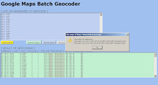
Copy and Paste in the top light blue box, wait until the alert shows the copy and paste from the bottom green box into a New Spreadsheet.
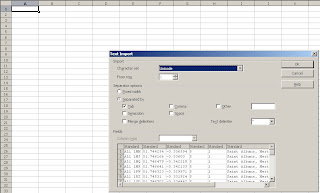
Paste into Open Office Calc or Excel with the correct delimiters.
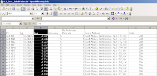
Make the pasted lat and lng's six figures in decimal places
save the spreadsheet
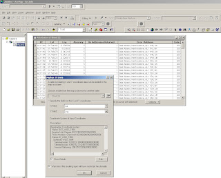
Add the Spreadsheet to ArcGIS (will need a double click if more than 1 worksheet is in the file)
Use WGS84 Geographical Projection to set the Excel Spreadsheet into the correct projection
Use Add XY Data add the data by Lat/Lng and an event theme will be created, this can be exported out as a shapefile or geodatabase.
Important Note: Geocoder Accuracy ALWAYS check Accuracy - this shows that the all Geocoders have limitations
This compares Codepoint (accurate to 100m) to the Google Geocoded Postcodes and there is approximately +/- 150 metres error in their location.
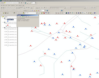
Blue is OS Codepoint in Geographic WGS84
Red is the Google Geocoded Postcodes
(used for a comparison only!)
The method is useful for small datasets, depending on your use.
It could be easily changed to load the geocoded data into a MySQL or Postgres databases for spatial retrieval and added back on to web mapping applications.
Yahoo does Geocode UK Addresses (in some cases more accurate) but it's limitation is that it can only be used on it's on Mapping API and the Geocoder is limited to just 5,000 requests per 24 hours.
For Manual Geocoding
Please use the Official Example:
http://gmaps-samples.googlecode.com/svn/trunk/geocoder/singlegeocode.htmlLabels: Accuracy, ArcGIS, Batch, Geocoder, Geocoding





