->

22 August 2011

Bing Maps Streetside - London UK

Bing Maps Streetside - London UK

Bing Maps Streetside - London UK
Streetside is now available for some parts of London, England

Bing Maps Streetside - Westminster Bridge London UK
Westminister Bridge, London Bus and London Eye Iconic Landmarks, but do not expect 'Google Streetview' type functionality this is more a slide-show of images.


More information on Streetside
http://www.microsoft.com/maps/en-GB/streetside.aspx

View Streetside - London UK (click the icon next to Traffic)
http://www.bing.com/maps/?v=2&cp=51.50085314131346~-0.12088798043215165&lvl=14&dir=0&sty=r&trfc=1&form=LMLTCC

cross-posted from BingMapsWatch

Labels: , , , ,

07 January 2011

#ukfuel Bing Maps

#ukfuel Bing Maps

#ukfuel Bing Maps

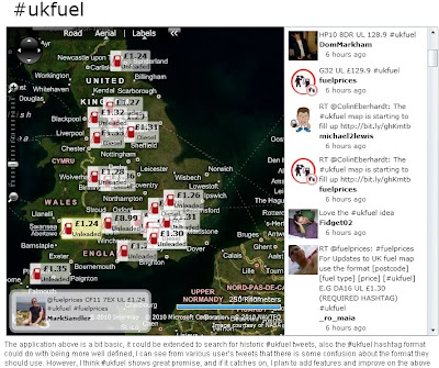
Same concept as Ben Marsh's http://uksnowmap.com/ but with UK fuel prices and UK Post Codes and twitter mapped out on Bing Maps

The format of #ukfuel tweets is as follows:
[postcode] [fuel type] [price]

For example:

DA16 UL £1.30

http://www.scottlogic.co.uk/blog/colin/ukfuel-a-twitter-bing-maps-mashup-for-tracking-fuel-prices/

cross-posted from http://bingmapswatch.blogspot.com/

Labels: , , , , ,

17 November 2010

Cornwall Flooding - November 2010

Cornwall Flooding - November 2010

Cornwall Flooding November 2010

Submit a Flooding Report
Cornwall Flooding November 2010 Submit


About This Project

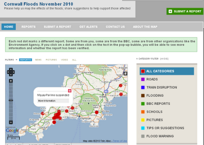
"This is an experimental project created by BBC Cornwall to map reports of the floods. We will add our reports but we'd love you to add your experiences and your tips for helping the community."

You can submit a report by:

a) Sending an email to radio.cornwall@bbc.co.uk

b) Sending a tweet with the hashtags #cornwall #flood or #floods

c) Filling in the form on this site http://cornwallfloods.crowdmap.com/

When you send your reports or comments, they will be put up on the map.


http://cornwallfloods.crowdmap.com/

Labels: , , , ,

27 July 2010

The UK SoundMap Beta - British Library

UK SoundMap starts with a pilot survey based on the Sheffield metropolitan area. The national survey will follow later in 2010. 
The UK SoundMap Beta - British Library


Make sure Location Services in Settings/General is switched on. Otherwise you can edit your recording on Audioboo FM and add a location by placing the microphone icon on the map at the place where you made the recording

How can I take part?

If you can make recordings in any location within the Sheffield area, please record your surroundings, describe them with tags and comments, then upload the recordings to our map. From there, a permanent public record of everyday sounds - the UK SoundMap - will be made accessible to everyone, while being stored at the British Library and made available to soundscape experts.

Want to add your sounds to the map then follow these steps;

  1. register with AudioBoo
  2. record & publish
  3. listen to soundscapes

Ways to record and publish

There are two ways. The easiest way is to use a smartphone. Alternatively you can use a web browser.

Listen to soundscapes

Once uploaded, your recordings will be found easily as locations on the soundmap and searchable by tags. Please allow 48 hours for your recordings to appear on UKSoundMap. You can meanwhile check your recordings right away on AudioBoo.fm

  • Just record your everyday surroundings.
  • What do your home, leisure and work environments sound like?


    • What sounds define these places and how do they make you feel? Some may be restful, some unpleasant - let us know why.
  • Does the sound of these places differ during the day?


    • What are the differences? Let us know what these sounds mean to you.
  • Where are the noisiest or quietest parts of your locality?


    • What makes it so noisy? What can be heard even when it's quiet?
  • Make as many recordings as you like at different locations and times.
  • Each recording may be up to 5 minutes long.
Map
http://sounds.bl.uk/uksoundmap/map.aspx

Source:
http://sounds.bl.uk/uksoundmap/index.aspx

    Labels: , , , ,

    28 June 2010

    Download ESRI ArcGIS 10 - Released

    Download ESRI ArcGIS 10 - Released

    Finally ArcGIS 10 has put the 'E' back in Environmental Systems Research Institute

    updated: 21:38 BST 28th June 2010.

    Read the Requirements before thinking of downloading

    "ESRI (UK) is pleased to announce that ArcGIS® 10 will be available shortly. ArcGIS 10 will revolutionise how organisations use geographical data and delivers a host of new possibilities."

    "The ArcGIS 10 software will be available as a download from week commencing 28 June or on DVD at a later date." [But when?]

    Users with a maintenance plan can download the software (3.2GB +8.0GB for ArcGIS 10 Data)ESRI ArcGIS 10 Released - Downloadable

    ESRI UK has re-vamped their site to include ArcGIS 10 (not just re-directing to the US site)

    Here are the links (note: don't try downloading whilst viewing videos unless have a super-fast broadband connection)

    ArcGIS 10 Demos:

    Introduction to ArcGIS 10
    Usability Enhancements (10 usability enhancements in ArcGIS Desktop)
    3D in ArcGIS 10 (display, analyze, and maintain 3D data in ArcGIS 10)
    Enhanced Map Editing (enhanced map editing tools and workflows)
    Modeling and Analysis (more productive, access data faster, and generate better models and results)
    Mapping Workflows ( create, manage, and share your maps more efficiently)
    Production and Automation (Python window in ArcGIS 10 MapBook, Sharing)

    UK Users of UK Specific Products

    UK Product Compatibility Status

    ProductCompatibility Date
    ProductivitySuiteJuly 2010
    CrimeAnalystAugust 2010
    LocalView FusionAugust 2010
    LocatorHubSeptember 2010
    http://www.esriuk.com/arcgis10/existing_customers.asp
    Full Product list

    Please note the web browsers below are supported for the ESRI Customer Care Portal from which our customers will download ArcGIS 10
    Internet Explorer: version 6+
    FireFox: all versions
    Chrome: all versions
    Safari: all versions
    Opera: 9+
    Additionally users will need Flash Player 9+ installed and JavaScript enabled to use the site.

    FILE SIZES - BIG
    Product LineProducts Available for DownloadFile Size (approximate)
    ArcGIS DesktopArcGIS Desktop 103.2 GB

    ArcReader 101.6 GB

    ArcGIS Desktop Tutorial Data 102.0 GB

    ESRI Data & Maps for ArcGIS 108.0 GB


    ArcGIS Server EnterpriseArcGIS Server Enterprise 10 for Windows3.0 GB

    ArcGIS Server Enterprise 10 for Red Hat Linux Enterprise and SUSE Linux Enterprise3.2 GB

    ArcGIS Server Enterprise 10 for Sun Solaris on SPARC3.2 GB

    ArcSDE 10 for Windows1.0 GB

    ArcSDE 10 for UNIX2.5 GB

    ESRI Data & Maps for ArcGIS 108.0 GB

    ESRI Data & Maps for ArcGIS Server 108.0 GB


    ArcGIS Server WorkgroupArcGIS Server Workgroup 103.5 GB


    ArcGIS Engine Developer KitArcGIS Engine Developer Kit 10 for Windows2.6 GB

    ArcGIS Engine Developer Kit 10 for Red Hat Linux Enterprise and SUSE Linux Enterprise and Sun Solaris on SPARC2.75 GB

    ArcGIS Engine Runtime 102.6 GB


    ArcGIS Engine RuntimeArcGIS Engine Runtime 102.6 GB


    ArcIMSArcIMS 103.4 GB

    ArcIMS Gazetteer0.65 GB


    ArcInfo WorkstationArcInfo Workstation 10 for Windows & Sun Solaris on SPARC1.9 GB


    ArcGIS Image ServerArcGIS Image Server 100.50 GB


    ArcGIS Workflow ManagerArcGIS Workflow Manager 100.07 GB


    ArcGIS Server Workflow ManagerArcGIS Server Workflow Manager 100.08 GB


    ESRI Mapping and Charting SolutionsESRI Production Mapping 100.25 GB

    ESRI Aeronautical Solution 100.35 GB

    ESRI Defense Mapping 100.40 GB

    ESRI Nautical Solution 100.35 GB


    ArcGIS Data ReviewerArcGIS Data Reviewer 100.10 GB


    Tracking ServerTracking Server 100.50 GB


    ArcPadArcPad 100.20 GB

    ESRI StreetMap Premium Tele Atlas North America (USA and Canada)2.0 GB

    ESRI StreetMap Premium Tele Atlas Europe3.0 GB
    US Site:

    Labels: , , , , ,

    21 June 2010

    UKFreeTV Creates Freeview Digital Coverage Map

    UKFreeTV Creates Freeview Digital Coverage Map (Beta)

    Over the last month Mapperz has seen this excellent (though still in beta) Google Map Mashup develop with comments and feedback from users of this free service being acknowledged by the creator.
    [which is 100 times better than the official site that can only do postcodes searches but no visualisation]
    The site is developed and maintained by @briantist (Brain Butterworth) and well done for taking the time to compile and map UK Digitial TV Coverages which does include Freeview HD coverage.

    UKFreeTV  Creates Freeview Digital Coverage Map Example

    Yellow is the area where the transmitter provides the best signal, green is where there is overlap and the selected transmitter is not the strongest signal.

    Example: http://www.ukfree.tv/transmitters.php?P=RH130TR&s=map

    The green/yellow fades to white where the signal is weakest.

    Other Features:
    The new Freeview prediction system - includes Freeview HD
    • Now with any date choice
    • Terrain mode (beta) - profile see below
    UKTV digital TV map terrain profile
    Terrian or Profiles of the Transmitters to your choosen location (postcode)

    There are five different views
    • By direction: this will show the various directions your aerial might point and the services you can receive from the transmitters in that direction
    • Received signal strength: this shows the information ordered by signal strength, to help you find the strongest signals.
    • By frequency: this lists broadcast frequencies from C21 to C68, showing the services on each. This view can be used to find potential interference or to help with digital region overlap areas.
    • Service names: this lists the services that you can receive, each ordered by the strongest signal.
    • Transmitter names: and finally an alphabetical list of the transmitters with the services listed by broadcast frequency.

    Note Terrain Mode(beta) the diagrams (can take several seconds to generate) below show the terrain between the selected location (postcode) and a number of transmitters. Green is used to denote ground, blue for water, with the transmitter on the right.

    The values shown in meters are the height above sea level (for the receiver and transmitter aerials), the value in kilometres is the distance from the transmitter. Also shown as a value in degrees in the bearing, with each block being a kilometre step along the way.

    Signal Strength
    UKTV Digital TV by signal strength title=
    Users can drill-down to individual channels if required.

    Reception requires a line-of-sight between the transmitter and receiver aerial. Distant transmitters will, during periods of Inversion become visible and (unintentionally) they may adversely effect reception.

    Sources:
    http://www.ukfree.tv/fullstory.php?storyid=1107051660

    http://www.ukfree.tv/starthere.php

    Map Example (RH130TR Postcode)
    http://www.ukfree.tv/transmitters.php?P=RH130TR&s=map

    One of the best individual Google Map Mashups to date (21th June 2010).

    Labels: , , , , , , ,

    05 May 2010

    UK Election Map #ge2010

    UK Election Map #ge2010
    UK Election Geo.me tweets map

    View live geotagged tweets over a constituency map of Britain. Recent geotagged tweets are shown, so the tweets you see have been sent from the actual locations shown.

    Twitter Controls: Use the yellow search box to search for specific terms. You can disable automatic reloading, force a reload and clear the map using the panel controls. Loading status and popular hash-tags (#geo2010) are shown at the bottom of the panel.

    Constituency Data: the constituency map uses the new 2010 boundaries released as Ordnance Survey Open Data, coloured by the notional 2005 election results, as provided by the Guardian Data Store. Zoom closer to see constituency names. Boundaries for Northern Ireland constituencies are not yet available as open data.

    Important Note: the map shows only properly geotagged tweets, made by users who have enabled this feature. This represents only a small proportion of all tweets.

    UK Election Map
    http://www.geo.me/election

    source:
    http://googlemapsmania.blogspot.com/2010/05/uk-election-on-google-maps.html

    Labels: , , , , , , ,

    21 April 2010

    Google's FREE Navigation killer - now released for the UK

    Google's FREE Navigation killer - now released for the UK ( & Ireland)

    Google's FREE Navigation Killer
    Image:The Guardian

    http://www.google.com/mobile/navigation/

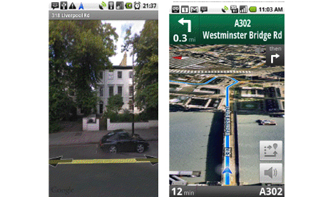
    Killer Features:

    1. FREE
    2. Voice Commands
    3. Traffic Indicator (Red Slow/Stop, Yellow, Green Go.)
    4. Map, Satellite and Streetview modes
    5. There are already upwards of 50 million people using Google Maps.

    Full Article by Jemma Kiss
    http://www.guardian.co.uk/media/pda/2010/apr/21/digital-media-google

    Download Google Maps Navigation
    http://www.google.com/mobile/navigation/

    Labels: , , , ,

    25 March 2010

    @Nomads_land got Ordnance Survey Maps!

    @Nomads_land got Ordnance Survey Maps!

    What's the story here?

    Ordnance Survey have helped the request for Ordnance Survey maps for a long walk (7,000 miles) around the United Kingdom for 3 UK Charities by Nathaniel Severs
    Ordnance Survey
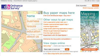
    http://www.ordnancesurvey.co.uk/oswebsite/

    The Three Charities:
    1. Southampton General Hospitals Paediatric Physiotherapy department
    2. The Stroke Association
    3. The Mammal Society
    The request:
    requested: 10:33 AM Mar 16th via Twitter on the web
    S: Right Twitter,Nat is after some maps for the Scottish leg of the walk. SO, has anyone got OS Maps of scotland they could donate?Please RT

    @mapperz picked up this request after following the daily tweets from @Nomads_land on his walk around the UK coast.

    Basically mapperz has a number of good contacts, those contact have even better contacts.
    Enter @StevenFeldman to the request and things really start moving and thanks to him Ordnance Survey have given the maps away for the Scottish leg of the 7,000 mile journey. That's over 40 1:25,000 Explorer Maps and a geo success of social networking that can be achieved.

    More info on the guy doing the work:
    "My names is Nathaniel Severs, I am 24 years old and in 2010, I am walking the entire coastline of mainland Britain (7,000 miles) for three great charities."Nomad's Land Big Walk Blog
    Keep up to date on the Big Walk on http://natsevs.wordpress.com/

    "I set out from Portsmouth on 10 January accompanied only by a large rucksack carrying my tent and kit. I camp most nights but am open to offers for accomodation! The entire journey will be completed using leg power and if there is a bridge, I will be crossing it (so Anglesey and the Isle of Skye will both be on the agenda). I will stay true to the coastline at all times, so if there is a ferry across a river (the River Dart, for example) that is not classed as coastline, then I will allow myself to take a ferry if one is available. But a ferry cannot be used at any other time. I aim to be home by Christmas!"

    The journey so far
    Nats Big Walk Route
    Natathan is currently along Pembrokeshire Coast Path [Fishguard] (a very nice walk rain or sun)
    Follow his progress here http://natsevs.wordpress.com/progress/

    Many thanks to:

    @Nomads_land for taking up the challenge to walk around the entire UK coast
    http://natsevs.wordpress.com/

    Steven Feldman (@StevenFeldman)
    http://giscussions.blogspot.com/

    Ordnance Survey for being so quick to respond and making the solution to the request.
    hopefully a post on http://magazine.ordnancesurvey.co.uk/magazine/tscontent/editorial/exploremagazine/ about this soon?

    Social networking Site Twitter - http://twitter.com/ connecting us all up.

    and myself Mapperz @mapperz for helping a good cause.

    Labels: , , , , , , ,

    11 March 2010

    UK Streetview - FULL Coverage

    UK Streetview - FULL Coverage

    updated...

    http://maps.google.co.uk/?ie=UTF8&hq=&hnear=United+Kingdom&ll=53.343993,-5.185547&spn=8.217413,23.269043&z=6
    (and drag the yellow pegman)

    Longest unbroken Trip in Streetview for the UK now possible

    http://mapperz.110mb.com/GMAP/LongStreetView_UK.html
    838 mi (about 15 hours 2 mins)

    England, Wales, Scotland and Northern Ireland Full Coverage.

    (Republic of Ireland streetview coverage is likely in due course.)

    New Content:

    Visit Wales in Streetview
    http://tinyurl.com/visit-wales-view
    NationalTrust in Streetview (better coverage)
    http://tinyurl.com/NationalTrust-view

    Note:some images are over 1 year old since google recorded them.

    Big Brother is now complete for the United Kingdom.

    mapperz

    Labels: , , , , , ,

    05 January 2010

    A Real Snow Map #uksnow

    A Real Snow Map #uksnow

    updated 17.51 06/01/2010

    A Real Snow Map

    via @jasonhesse

    More Interactive Maps are
    UK SNOW MAP
    http://www.raintoday.co.uk/

    The Met Office Invent site
    http://www.metoffice.gov.uk/public/pws/invent/weathermap/

    BBC Weather
    http://news.bbc.co.uk/weather/forecast/10209


    Wunderground
    http://www.wunderground.com/global/UK.html

    #uksnow Map 2.0
    http://uksnow.benmarsh.co.uk/

    UK Snow Dynamic Crowd Sourced Maps

    The UK has been experiencing a snow storm recently and people have been tweeting about it!. This page has been setup, as part of my research into crowd sourcing, to track the #uksnow hashtag based on the following format [Postcode District Score/10] since #uksnow became a trending topic. You can help out by tagging the current snow conditions in your own Tweets like this:
    http://www.casa.ucl.ac.uk/sjg/twitter/

    more info - http://stevenjamesgray.com/projects/uksnowmaps/


    Labels: , , , , , ,

    17 December 2009

    Live Snow Radar Map UK

    Live Snow Radar Map UK
    *almost live

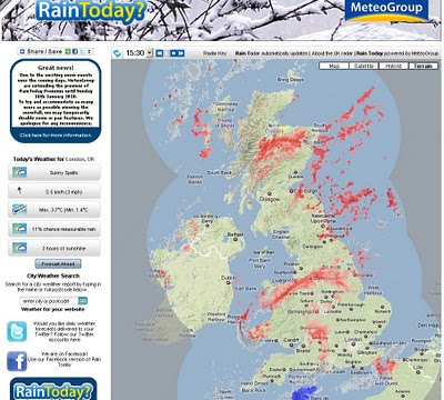
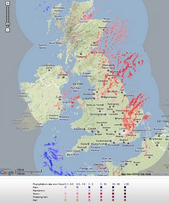
    Live Snow Radar - UK Map
    Pink and Red highlights snowfall - blue and purple represents rain.

    "Radar is a remote sensing tool used by weather forecasters to analyse the extent and intensity of precipitation. Radar detects objects by transmitting radio waves which are reflected back to the starting point by any object they encounter. Distance can be calculated using the speed of the radio waves and the amount of time that each pulse takes to reach the object and return back to the starting point. Rain, snow and hail all stop the radio waves. The more pulses that are reflected back, the greater the intensity of the precipitation."

    http://www.raintoday.co.uk/static/about_radar.html


    View the map in near real-time
    http://www.raintoday.co.uk/

    powered by Meteogroup and Google Maps API

    source: @mapperz

    Labels: , , , , , , ,

    11 November 2009

    Marine Protected Area (MPA) Map - UK

    Marine Protected Area (MPA) Map - UK

    Marine Protected Areas Map
    The interactive map illustrates the location of the different MPAs in the UK. For each site there is information about its designation, interest features and a link to a relevant website.

    A Marine Protected Area (MPA) is often defined as any area of intertidal or subtidal terrain, together with its overlaying water and associated fauna, flora, historical and cultural features, which has been reserved by law or other effective means to protect part or all of the enclosed environment.

    Related to this is the Marine and Coastal Access Bill
    "The Marine and Coastal Access Bill will ensure clean healthy, safe, productive and biologically diverse oceans and seas, by putting in place better systems for delivering sustainable development of marine and coastal environment."
    More Information
    http://www.defra.gov.uk/environment/marine/legislation/index.htm

    Labels: , , , , ,

    16 September 2009

    ALL 1,841,177 UK POSTCODES FREE'D?

    ALL 1,841,177 UK POSTCODES FREE'D?


    Example of UK Individual Postcodes

    Example of UK Individual Postcodes (density)
    image source:

    http://da.vidnicholson.com/2006/12/uk-postcode-coverage-map.html


    According to the Guardian:

    "Wikileaks is hosting what it says is a copy of the entire UK postcode list, last updated on July 8 2009, that contains "all 1,841,177 UK post codes together with lattitude [sic] and longitude, grid references, county, district, ward, NHS codes and regions, Ordnance Survey reference, and date of introduction. The database ... is over 100,000 pages in size."

    The 230MB file, zipped to 20MB, does indeed contain a huge slew of postcodes in comma-separated form, with those details as headers for each column.

    Oh my. We have no idea who has leaked this, but it is the gateway to some valuable information: Royal Mail, as we ascertained previously in the Free Our Data campaign, sells the Postcode Address File (aka PAF) for a considerable sum, and makes a good profit on it: in August 2007 the postal regulator Postcomm revealed that PAF operations made a profit of £1.58m on revenues of £18.36m, all but £4m from resellers."

    Data seems to be

    Postzon™

    "links Postcodes and addresses to geographical data"

    http://www.royalmail.com/portal/rm/jump2?mediaId=400088&catId=400084

    so there is a licence cost:

    System licence £1,000
    Multi-system licence £3,000
    Corporate licence £25,000

    Full story:

    http://www.guardian.co.uk/technology/blog/2009/sep/16/wikileaks-postcode-file-free-data

    More information on UK Postcodes

    http://en.wikipedia.org/wiki/Postcodes_in_the_United_Kingdom

    If you want a non-derived Royal Mail/Ordnance Survey and Free Postcodes without an annual licence.

    http://www.freethepostcode.org/currentlist


    Labels: , , , , , ,

    30 June 2009

    The Met Office (Google Maps) Weather

    The Met Office (Google Maps) Weather

    The Met office are experimenting with the Google Maps API - this is a very interesting move. The results are quite impressive and this is a potentially a bold move and a great way to represent weather forecasting on the web.
    This includes animating the weather for the next 24hrs using the time bar above the map.

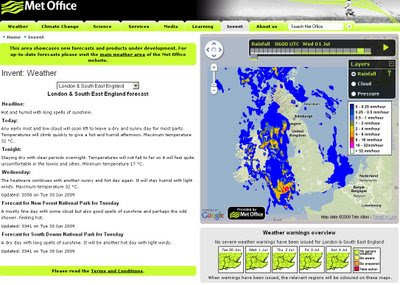
    The Met Office Weather using Google Maps 1st July
    Google Maps API with Meteorological Data overlayed to represent very visually the foretasted weather for the UK. Animation is controlled by the 'Play' Button.

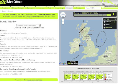
    Not only is rainfall overlayed but isobars representing the pressure is also animated.

    The Met Office Weather using Google Maps Isobars
    Isobars (Barometric Pressure) overlay on Google Maps

    There is Temperature, Winds(strength/direction) missing currently, this is planned for the future and will be very useful for users.

    This is an impressive experiment and greatly improves the very static generated images that currently dominated the Met Office Website.

    Well done to all involved, this is what the public want.

    The Met Office Google Map (Experimental)

    Currently the BBC have Temperature and Winds [Flash required]
    http://news.bbc.co.uk/weather/forecast/10209

    Suggestions - Opacity Control - current radar blocks the background map.
    Temperature and Winds layers would be very handy.
    5 day forecast possible?
    An a final request on the raw data - it possible to have a basic GeoRSS feed for budding developers to create weather overlays for their own maps
    GeoRSS weather warnings?

    Labels: , , , , , ,

    16 June 2009

    MSN UK - Local Maps with Local Information

    MSN UK - Local Maps with Local Information

    Microsoft new service for the United Kingdom:

    "a market-leading range of data to allow people to conduct personalised searches of any UK neighbourhood and create an-easy-to-understand map, with all relevant information displayed succinctly on one page."


    MSN UK - Local Maps with Local Information
    MSN UK overlay Local POI (Points of Interest) for the current map, panning or zooming automatically updates the map with more local information based on users choices in the sidebar.

    The coloured polygons represent the local constituencies though out the UK.

    One option that is interesting is 'Flood Layer' though not currently available - issues with Crown Copyright and the Environment Agency? ononemap.com has the same issue.

    MSN UK Local Map Local constituencies Bing Maps


    property portal Propertyfinder.com and Virtual Earth (now Bing) developers shoothill.comMSN UK Local Map Local House Price Heatmap Bing Maps
    Find out where "Risers & Fallers" are with this heatmap

    Overall , lots of data, managed in a way that it is not totally overload the base maps [TeleAtlas, Ordnance Survey and Collins Bartholomew background maps available].
    A good selection of local information is currently available.

    Bird Eye View is available but local information is not overlayed - am sure Multimap has this available (Multimap now owned by Microsoft)
    See http://www.multimap.com/s/JV2Swe8T
    for points in Bird Eye View.

    Source:
    http://www.techradar.com/news/internet/msn-offers
    -localised-property-info-service-608518

    Labels: , , , , , , , ,

    10 June 2009

    The UK Blue Badge Map [via direct.gov.uk]

    The UK Blue Badge Map [via direct.gov.uk]

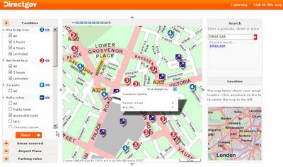
    Finally a very useful map that will help aid 'Blue Badge' users finding parking across the UK.

    Blue Badge Parking Map - UK

    The Blue Badge map can be used to find:

    • Blue Badge parking bays in over 100 towns and cities across the UK
    • Red Route parking bays in London
    • petrol stations and their service facilities on major routes in the UK
    • accessible public toilets in over 100 towns and cities across the UK
    • railway stations and their accessibility
    • Underground stations and their accessibility in London
    • taxi ranks
    • Shopmobility centres
    • accessible beaches
    • Wheelyboat locations
    • Mobility Centres
    • locations of interest, like town halls, hospitals, museums and tourist attractions
    • parking rules for all councils in the UK
    The map features Blue Badge bays, council car parks, taxi ranks and public toilets in 115 towns and cities across the UK. Red Route bays in London are also covered.

    In addition, petrol stations along major routes are featured, indicating their services. This includes cash machines, 24-hour-opening, accessible toilets and ServiceCall

    New on the map are railway stations, including their access level. There are three access levels:

    • accessible - step-free access to all platforms and staff to help
    • partly accessible - step-free access to all platforms but there may not be any staff to help
    • inaccessible - steps to some or all platforms
    The Blue Badge Map
    http://bluebadge.direct.gov.uk/index.php?br_wid=1280&br_hgt=1024

    Well done to DirectGov for implementing this, it is very useful for all.

    Also available in Welsh.
    http://bluebadge.direct.gov.uk/cy/index.php?br_wid=1280&br_hgt=1024

    For more information about the map:
    Blue badge scheme map

    and how to get this information on your mobile device:
    http://www.direct.gov.uk/en/Hl1/Help/YourQuestions/DG_069492

    Related News:
    http://www.bbc.co.uk/blogs/ouch/2009/06/get_the_blue_badge_map_on_your.html

    Labels: , , , , ,

    01 June 2009

    http://www.theukmap.co.uk/

    http://www.theukmap.co.uk/

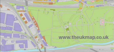
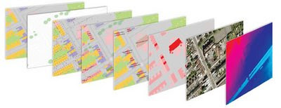
    01/06/2009 - Press Release The GeoInformation Group Announces UKMap Programme New large-scale mapping for the UK "Cambridge, 1 June 2009: The GeoInformation® Group today announces a ground breaking and innovative new mapping programme. UKMap® is the UK’s first commercially funded, large-scale topographic mapping and address database created completely independently of the Ordnance Survey®. "UKMap is a modern, highly detailed, feature rich mapping database. It comprises of several map layers designed to be used as a single integrated geographic information database. UKMap layers include a 1:1,000 scale topographic map layer accurately locating all buildings, extensions, garages, property boundaries, roads, road markings, rivers, trees and many other features of our environment. Other layers include a location database holding addresses, commercial and retail names, building heights, tree heights, street names, government offices, and place names. In addition to these layers there is an aerial photography layer and a digital terrain model."

    The UK Map

    Is the data derived from the Ordnance Survey?
    NO!
    "No absolutely not. All the buildings, roads and all line work was digitised from our own aerial photography, and all the information collected in the field by our survey team was done so by writing down on our digitised maps everything they could see. The only piece of third party data that is within the UKMap database, and it is optional, is the Postcode"

    Detailed Method for the digital mapping layers:
    "Well first we use our latest high resolution aerial photography, all captured using a very advanced digital camera at 12.5cm resolution. The aerial photos are orthorectified using GPS and a very detail terrain model from our own Cities Revealed LiDAR database. This gives us a very accurate stereo aerial photo database from which we can digitise; the accuracies of our air photo database and the subsequent features we digitise have been tested and show absolute positional accuracies compared to independent GPS points of 0.7m RMSE (Root Mean Squared Error). We then digitise, using stereo pairs, all features we can see in the photo, such as fences, buildings, road markings, trees bridges etc. These are all digitised with some key tools so we ensure parallel lines, right angled corners and splines for curves. This all makes for a much neater, accurate and cartographically improved line map. The digitised maps are then printed and sent out to our field survey team who then walk every street, park, office complex in fact anywhere where there is public access to collect all the information we need and add that to our map, this includes house numbers, street names, shop names, locality information, office names etc. All this data is then complied into the UKMap database. "


    UKMap is made up of the Topo product suite, comprising of 8 map layers, and the Thematic product suite, a 1:5,000 scale map layer with annotations for use on the web.

    This is very good.TheUKMap Layers

    Why use it?
    Cost
    1. Cost Savings
      UKMap contains a number of data layers that you would normally pay extra for:

      • Addresses
      • Points of interest including retail and commercial data
      • BLPUs
      • Aerial photography
      • Terrain
      • Land Use
      • 3D buildings
    Discover more on this at http://www.theukmap.co.uk/

    Labels: , , , ,

    27 May 2009

    UK Broadband Notspots

    UK Broadband Notspots

    Lots of noise about where UK Broadband exists and does not exist - which is more important?

    UK Broadband 'notspots' map

    The UK Broadband Notspots (slow broadband or no broadband)
    http://www.broadband-notspot.org.uk/coverage-map.html

    Or by County
    http://www.broadband-notspot.org.uk/maps-by-county.html

    Define: Broadband
    (typically speeds above 2mb bandwidth)

    "The broadband comparison site SamKnows.com composed a connection map which shows graded postcode areas with a connection speed according to their distance from the UK's 5,500 telephone exchanges. Any more than 4km from an exchange and the speed drops below 2Mbps - but that's the case for 50% of homes in Basingstoke and about 25% of homes in Hampshire. Around 1% of UK homes can't get any broadband connection.

    SamKnows co-founder Alex Salter said decent broadband has economic implications for both consumers and businesses. "In some cases people aren't able to shop online, aren't able to view certain websites or use social media applications such as Facebook and Twitter and they can't watch the BBC's iPlayer.

    "It prevents flexible working. If the problem is fixed it means a lot more people could work from home which offers a very real way to improve society."

    source: Jemima Kiss - Broadband Britain: Can you get 2Mbps? The Guardian

    Media Coverage:
    http://www.guardian.co.uk/media/pda/2009/may/27/broadband-digital-media
    http://news.bbc.co.uk/1/hi/technology/8068676.stm

    Labels: , , , ,

    13 April 2009

    Super Heatwave in April? [BBC Weather Map]

    Super Heatwave in April? [BBC Weather Map]


    Super Heatwave - BBC Weather Error

    According to BBC Weather there is a SuperHeatwave [36+ degrees] in the North of England at 12 noon today.

    When data feeds go wrong?


    The Met Office [Offical UK source] has a more normal prediction
    Met Office - Normal Prediction
    http://www.metoffice.gov.uk/weather/uk/uk_forecast_temp.html


    Surprisingly it looks like and error on the BBC Weather side as they use Met Office data.

    Labels: , , , ,