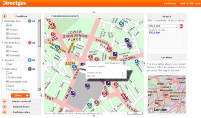
The UK Blue Badge Map [via direct.gov.uk]
The UK Blue Badge Map [via direct.gov.uk]
Finally a very useful map that will help aid 'Blue Badge' users finding parking across the UK.
The Blue Badge map can be used to find:
- Blue Badge parking bays in over 100 towns and cities across the UK
- Red Route parking bays in London
- petrol stations and their service facilities on major routes in the UK
- accessible public toilets in over 100 towns and cities across the UK
- railway stations and their accessibility
- Underground stations and their accessibility in London
- taxi ranks
- Shopmobility centres
- accessible beaches
- Wheelyboat locations
- Mobility Centres
- locations of interest, like town halls, hospitals, museums and tourist attractions
- parking rules for all councils in the UK
In addition, petrol stations along major routes are featured, indicating their services. This includes cash machines, 24-hour-opening, accessible toilets and ServiceCall
New on the map are railway stations, including their access level. There are three access levels:
- accessible - step-free access to all platforms and staff to help
- partly accessible - step-free access to all platforms but there may not be any staff to help
- inaccessible - steps to some or all platforms
http://bluebadge.direct.gov.uk/index.php?br_wid=1280&br_hgt=1024
Well done to DirectGov for implementing this, it is very useful for all.
Also available in Welsh.
http://bluebadge.direct.gov.uk/cy/index.php?br_wid=1280&br_hgt=1024
For more information about the map:
Blue badge scheme map
and how to get this information on your mobile device:
http://www.direct.gov.uk/en/Hl1/Help/YourQuestions/DG_069492
Related News:
http://www.bbc.co.uk/blogs/ouch/2009/06/get_the_blue_badge_map_on_your.html
Labels: Blue Badge, DirectGov, Facilities, Map, Parking, UK


0 Comments:
Post a Comment
<< Home