Mapperz - The Mapping News Blog
Mapperz - The Map & GIS News finding blog. With so many Mapping sites online. This blog tries to provide you with the best maps and services that are currently available online. @mapperz
29 February 2008
Google Maps API Demo Gallery +Resources
Google Maps API Demo Gallery

A useful resource for finding and building Google Maps Applications
"Why re-invent the wheel when you can copy and paste our wheel instead?"
Other Recommended Resources
http://econym.googlepages.com/index.htm
http://www.usnaviguide.com/
Want more Advanced Examples then join the Google Maps API Group and ask.
Labels: Gallery, Google Map API, Group, Resources
27 February 2008
UK Earthquake Map
Update 28/02/2008
From the comments
http://virtualtourism.blogspot.com/2008/02/uk-earthquake.html
UK Earthquake Map
View Larger Map
"The British Geological Survey recorded an earthquake with a magnitude of
5.2 ML 4 km north of Market Rasen, Lincolnshire, at 00:56 GMT. The BGS has
been inundated with calls from the public, media and emergency services
throughout England. By 7 am this morning, over 1,400 felt reports had been
received via the online questionnaire on the BGS website.
There is a report of one person having been injured.
Reports indicate that the earthquake has been felt widely across England, with reports
of damage to chimneys in the epicentral area. Earthquakes of this size occur in
the mainland UK roughly every 30 years, although are more common in
offshore areas. This is the largest earthquake in the UK since the magnitude
5.4 ML Lleyn Peninsula."
Source:
http://www.telegraph.co.uk/news/main.jhtml?xml=/news
/2008/02/27/nquake527.xml
data source:
http://pasadena.wr.usgs.gov/shake/ous/STORE/
X2008nyae/ciim_download.html
Labels: Data, Earthquake, Magnitudes, Map, Source, UK
New York Times - Mapping the other 70%
New York Times - Mapping the other 70%
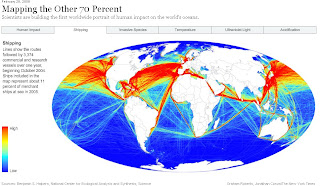
Shipping is impacting oceans across the globe.
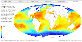
Acidification is also impacting oceans across the globe.
All the maps
"scientists are building the first worldwide portrait of such dispersed human impacts on the oceans"
Full article
http://www.nytimes.com/2008/02/26/science/earth/26coas.html
Credit to Benjamin S. Halpern, National Center for Ecological Analysis and Synthesis; Science
& New York Times Graham Roberts, Jonathan Corum
Labels: Human Impact, Maps, NCEAS, New York Times
25 February 2008
What's New in ArcGIS 9.3?
What's New in ArcGIS 9.3?
ArcGIS 9.3 is expected to be available in the third quarter of 2008.
ArcGIS Desktop
The new Convert Graphics to Features dialog at ArcGIS 9.3
A new Convert Graphics to Features dialog has been added to allow you to create features by drawing graphics without using the editor.
For this function now go here ( Tools for Graphics and Shapes v. 1.1.76).
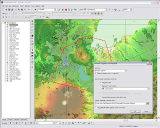
ArcGis 9.3 - Converting graphics to shapes
Pause Labeling
A new button in the Labeling toolbar lets you temporarily pause labeling to increase performance while you assemble the other layers in your map or do analysis. This saves you having to turn labeling off completely.
Manage Bookmarks
Bookmarks are much easier to access. You can also re-order and sort them, and export and load them between different data frames, maps and globes.
"Bookmarks are easier to access with the new Bookmarks pulldown menu. The 9.3 Bookmark Manager dialog lets you reorder bookmarks anyway you want and save bookmarks to a file for loading into other data frames, maps or globes. You can update the extent of an existing bookmark without having to recreate it. You can also save bookmarks into your My Places dialog so you can use the same bookmark in any map or globe you work with."
Data View and Layout Synchronised
Layer legends in the Table of Contents (TOC) and on your map layout automatically use lighter colors for symbols in layers that have transparency applied to them.
Full Table Joins
When you join tables, all of the field properties & field aliases, are now retained which makes working with joins much easier. You can now perform joins between layers or tables with definition queries defined and the definition queries are respected correctly.
There is now a toggle between showing field name aliases and showing the underlying field names. You can also sort a table on multiple attributes.
Full Identify Attributes
Identify window, the dialog will now respect all the field properties, such as primary display field, field aliases and field visibility, of any layer or table in your map that represents that related data in your map. Also when you identify a feature, you can now immediately launch the properties dialog and attribute table of the layer that the feature belongs to directly from the Identify window. This saves you having to look for a specific layer in the Table of Contents and is particularly useful when your map contains a large number of layers.
Address Geocoder and Reverse Geocoder
The new Address Inspector lets you click on a map to get the nearest address to any location
A new reverse geocoding tool called the Address Inspector lets you click on a map to get the nearest address to any location, and you can add that address to the map as a label.
Export & Clip Raster Data
It is now easier to export raster data. A new option within the Export Raster Data dialog in ArcMap lets you clip the output raster to the extent of the selected graphic(s) on your map.
Relative Scale Bar (1 in = 5 miles)
In 9.3 you can customize the scale control so that scales are always reported in relative format.
There is a now way to display map scales throughout the ArcMap user interface in relative format, such as 1 in = 5 mi, in the units of your choice, making scales easier to understand.
Double click Layer File (opens ArcMap)
Layer files are now registered with the ArcGIS Desktop applications. Double-click LYR files in Windows Explorer, Outlook, Windows Desktop to add them into your current map or launch ArcMap if it is not already running.
You can also click on LYR files presented on Web pages to add them into your maps, which provides internet data publishers with a simple way to provide ArcGIS Desktop users with access to their map services.
New Cartographic Tools
WYSIWYG (What You See Is What You Get) editing of cartographic representations has been added. When moving representations on a map, you'll be able to see the symbology instead of the wireframe outline so that you can better see how the edit will impact your map.
The new representation marker dispersal tool reduces the complex one-to-many relationship to a simple dynamic map
New Geoprocessing Tools
have been added to help with cartographic production. Disperse Markers has been added to allow you to spread representation markers apart which are coincident or nearly coincident. The new 'Set Representation Control Points at Intersect tool', you can now add a control point where coincident features share vertices.
New geometric effects
Move, Rotate, Scale, Wave, Tapered Polygon, and Regular Polygon.
*When exporting to XML, there is more information available about cartographic representations & rules.
Enhancements to Geoprocessing.
Within ModelBuilder, variables are more flexible in models and the 'Feature Record Set' and 'Record Set Controls' have been improved. More control over your geoprocessing model's parameters such as if a parameter is optional or required and what variable values are acceptable as inputs.
Script tools can now have multi-value outputs. The Results Window now shows environment settings. The Python scripting experience has also been improved. Python can now be run within an ArcGIS process.
**Error messaging has been revamped to make errors more descriptive and better linked to the help system. Messages are now standardized across all products, including ArcGIS Desktop extensions. These new, more informative messages will make it easier to build scripts and models.
Tool progress
messaging has also been improved and now more accurately displays actual progress. Not only will you be able to see how long an operation will take, but you'll know if the operation is proceeding as planned and not in some unknown state.
The 'Near' tool has been made more flexible and will now work with more than points and lines. It will perform calculations to all features within a given search radius. The ability to join to the closest feature has been added to the Spatial Join tool, making it easier to merge attributes.
New Spatial Statistics Tools
A new 'Generate Spatial Weights' tool in 9.3 gives you a new way to model spatial relationships. Its use results in a spatial weights file that is re-usable, editable, and sharable. A new 'Ordinary Least Squares Regression' (OLS) tool help you decide if your data is suitable for analysis using a global model that is the most commonly used regression statistic. The new 'Geographically Weighted Regression' (GWR) tool uses a local model for regional variations and helps you understand how processes vary of space.
ArcGIS Server
- Improved performance
- On-demand caching and improved caching geoprocessing tools will allow you to create faster mapping services.
- New image services will let you quickly publish imagery that is optimized for the Web.
- Better diagnostics
- Precise logs will enable you to easily identify bottlenecks and points of failure and improve your installation and configuration experience.
- New options in Manager will make it easier for you to secure Web services and Web applications
Major additions have been made to the online help and SDK documentation.
A new ArcGIS Server Resource Center brings together the set of online resources to help make you successful including blogs, samples, and best practices information.
Mapping API
ArcGIS Server 9.3 also introduces several important new features:
New REST and JavaScript APIs
These APIs will dramatically simplify your development experience and enable you to deliver fast and user-friendly mashup GIS Web applications.
***The JavaScript libraries will also let you embed ArcGIS Server maps, geocoding, and geoprocessing services into Google Maps API and Microsoft Virtual Earth API.
OGC and industry standards
New Open Geospatial Consortium (OGC) services support
Additional support for OGC and industry standards, such as Web Coverage Service (WCS), Transactional Web Feature Service (WFS-T), and KML 2.1, will improve your ability to integrate with virtually all the commonly accepted GIS and IT standards.
New PostgreSQL support - thank you ESRI! :)
(This gives you the ability to store and manage spatial information in this open source database system without ArcSDE.)
"The 9.3 release of ArcGIS Server represents a complete and integrated server-based GIS with significant quality enhancements and several new features that will make it even easier for you to create and manage end-user applications and services for spatial data management, visualization, and spatial analysis."
The Geodatabase
The geodatabase continues to be the common data storage and management framework for ArcGIS. At ArcGIS 9.3, the geodatabase offers improved spatial data management and enhanced capabilities for integration with enterprise systems.
ArcGIS 9.3 geodatabase enhancements include:
- Raster data management. New geoprocessing tools make the transfer of unmanaged raster catalogs (in Microsoft Access personal geodatabases and file geodatabases) from one location to another much easier
- Geodatabase replication. Microsoft Access personal geodatabases and file geodatabases can participate in one-way replication as child geodatabases
- ArcGIS 9.3 allows for more detailed logging of geodatabase replication activity.
ArcGIS 9.3 clients can make direct connections to pre-9.3 enterprise geodatabases (e.g., 9.2, 9.1, and 9.0).
Backward compatibility allows easier implementation of phased migration strategies for new ArcGIS releases.
Versioned editing
The Merge Geometries option enhances conflict and reconcile management.The Version Changes Viewer tool allows a version to be compared with an ancestor version without performing a reconcile operation.
Support for PostgreSQL (Open Source DBMS)
Enterprise geodatabases can be implemented on PostgreSQL with full support of the geodatabase data model.Vector geometry is stored in the ESRI spatial type.
PostGIS Open Source spatial type is supported.
Support for SQL Server 2008
The SQL Server 2008 release will introduce two spatial types: Geography and Geometry. These will be supported in enterprise geodatabases implemented on SQL Server 2008.
Operating System
New 64-bit platform support
Enterprise ArcSDE technology is now available as a native 64-bit application for Windows and Linux.
Source: ESRI (Mapperz edited for this post)
Labels: 9.3, ArcGIS, New Features, Postgres, SQL, Support, What's New
21 February 2008
Google 'Static' Maps API
Google 'Static' Maps API
"The Google Static Maps API lets you embed a Google Maps image on your webpage without requiring JavaScript or any dynamic page loading."
Pro's:
- No Javascript
- Works on standard webpages
- Designed for mobile/cell device developers
- Normal and Mobile Map Types
Con's
- Limited to only 1000 unique image requests per user per day.
- Limited function, non interactive
- GIF-format only
- Very long urls
Source:
http://googlemapsapi.blogspot.com/2008/02/google-maps-without-scripting.html
18 February 2008
TIGER,TIGER OpenStreetMap
TIGER, TIGER in OpenStreetMap
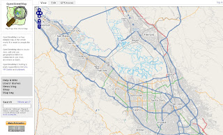
Well ahead of schedule TIGER data (USA) has been successfully imported to OpenStreetMap
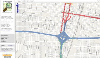
Clean, attributed data in OpenStreetMap
"OpenStreetMap (OSM) has completed the bulk import of comprehensive street and highway data for the United States, months ahead of the project's original estimates. The massive data set originated with the US Census Bureau's public domain map database, and importing it required a dedicated upload process running around the clock since August 2007. The imported data will still require human editing and error-correction, but the completed task is a major milestone for the OSM project."
How was this done so fast?
Once happy with the results, the project began importing the data into the main OSM system using three dedicated daemons running concurrently. Requiring all of the imported data to go through the OSM server's API just like manually collected GPS trace data meant it was a time-consuming process, but it was safer than attempting to bypass the API and alter the database directly.
Quadtiles to the rescue...
At the beginning of the process, the predicted completion date hovered between late May and early June 2008. Luckily, admin Tom Hughes found a way to re-index the database using quadtiles, resulting in greatly shortened database lookup times.
"Quadtiles recursively split each quadrant of the map into four sub-quadrants, allowing for better space efficiency by only subdividing those quadrants that require more detail -- a quadrant containing only ocean and therefore no roads, for example, would not require subdivision, whereas a metropolitan city center would."
Community Help
Now the real work begins, and you can help
The TIGER data set covers 6% of the Earth's surface. Its successful import does not mean that the work is finished. Users who have collected their own GPS logs in areas covered by the TIGER maps and uploaded the resulting data report sporadic problems with TIGER's information. Problems include misalignment of roads, missing features (including the regular absence of on-ramps and access roads, and representation of divided highways as a single road), and occasional confusion on features such as cul-de-sacs. Since the TIGER map data was produced from aerial photography, and was originally intended to assist Census Bureau officials in the field, such problems are bound to occur and are unlikely to have undergone official correction.
History
"OSM has performed one other bulk data import. In July 2007, AND Automotive Navigation Data donated a comprehensive road map of the Netherlands and highway system maps of India and China. The Netherlands import was completed last fall, but the data for the India and China import has yet to be released to the project.
Future
Although other prospects for large-scale map donations have been discussed, none are on the horizon. The addition of the AND and TIGER information gives the OSM project a helpful boost, but the bulk of the future work remains in the hands of individual users, each contributing their input toward the whole."
Some Random Places
Mountain View, Santa Clara
http://www.openstreetmap.org/?lat=37.3873&lon=-122.0877
&zoom=12&layers=B0FT
Seattle
http://www.openstreetmap.org/?lat=47.60933&lon=-122.33515
&zoom=15&layers=B0FT
Orlando
http://www.openstreetmap.org/?lat=28.6276&lon=-81.3724
&zoom=12&layers=B0FT
Labels: Data, imported, Open Street Map, quadtiles, Tiger
15 February 2008
OpenSpace API - More Examples Please
OpenSpace API - More Examples Please
15/02/2008
Keep them coming... (and keep asking the OS for 1:25,000 Explorer Mapping!)
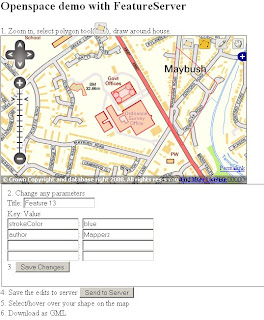
http://www.geothings.net/openspace/index.html
blog post
openspace-licences-limits-and-first-steps-plus-demo
OpenSpace API - More Examples Please
A few weeks on from the Ordnance Survey releasing the OpenSpace API there are a few that are taking up the small challenge and using the API to full effect.
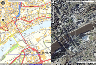
Very Clever
http://wheresthepath.googlepages.com/wheresthepath.htm
Note: Spilt screen half OS OpenSpace API and half Google Maps API Aerial imagery and is linked by location (pan and zooom can be enabled)
Blue transparent box shows the extent - switches between the maps.
Another Great Example
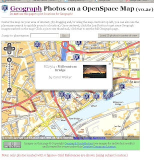
Geograph Photos on a OpenSpace Map (v0.2c)
http://openspace.nearby.org.uk/geograph.php
(Please do not use the page to plot locations for Geograph!)
Suggestions to make a better Mapping API - OS 1:25k would complete the set as there is a big jump between 1:50k mapping and 1:10k Streetview mapping.
Note: 1:25k is available on the Get a map service. Then you would be able to plan walking and hiking trips using the OpenSpace API. (1:25k has all public footpaths)
Not asking for 1:10k Rasters or MasterMap but there needs a scale.
There needs to be more Official Examples and better documentation with clear examples.
http://openspace.ordnancesurvey.co.uk/openspace/support.html
maybe and Advanced Section showing users the full potential of what can be done.
Working pages rather than static images with code would also be a helpful guide to newcomers to mapping API's.
Know of another OpenSpace API Map or have another suggestion? Then add yours via the comments.
Note:
"Newcastle-upon-Tyne" needs to be "Newcastle upon Tyne" or you will get an error.
Note:
"There will be a outage today 14th Feburary OpenSpace has a planned downtime from 5-6PM GMT today."
Labels: API, Exmaples, Maps, OpenSpace, Suggestions
13 February 2008
Spreadsheet Mapper 2.0
A Google tutorial shows you how to enter data in an on-line spreadsheet to generate a set of markers in Google Earth and Maps and Google Maps API. Google Docs' web-based, collaborative editing allows your team members to simultaneously enter data and instantly publish updates.
"Using this tool you could: showcase your organization's projects, program sites or partners; map your offices, volunteers, or resources; or visualize your data on local, regional or global scales."
Time to create Lines and Polygons...
Lines
Excel to KML (now with Line and Arrows from GPS track logs) http://www.earthpoint.us/ExcelToKml.aspx
Polygons
http://code.google.com/articles/support/ezdigitizer.htm
(copy and paste the code into excel or notepad and save as kml)
Official Link:
http://earth.google.com/outreach/tutorial_mapper.html
source: http://freegeographytools.com/
Labels: 2.0 Mapper, KML, Lines, points, Polygons, Spreadsheet
11 February 2008
Nokia Maps 2.0 Beta (pre-release)
Two blogs in one.... "Nokia aiming to banish paper maps" & Nokia Maps 2.0 Beta (pre-release)
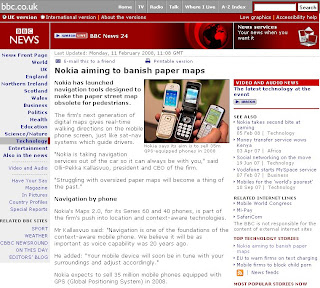
BBC News Technology
"Nokia expects to sell 35 million mobile phones equipped with GPS (Global Positioning System) in 2008"
Nokia Maps 2.0 Beta (pre-release)
What is new?
- Pedestrian mode
- Enhanced driving navigation mode
- Satellite maps
- Hybrid (satellite and important map features overlayed)
- Vastly improved search
- New real time traffic information
Official Release here

http://www.nokia.com/betalabs/maps
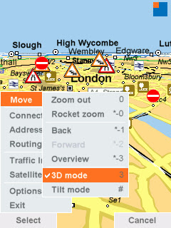
Screenshot of Nokia Maps 2.0
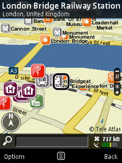
Image source: Allaboutsymbian
Beta means Beta! here are the known issues:
" We recommend you do not purchase or use Traffic info yet with this Beta release."
"New map data also still in beta and, for example, Taiwan, Hong Kong and Macau are not drawn correctly"
"N95 users, please make sure you have the latest firmware (v20.0.015)"
"The help texts have not yet been updated from previous Maps version"
"Localization is not completed in all languages so some menu items might still be in English"
"Please note that extra services like Drive and Walk navigation and City guides require" purchase."
Allaboutsymbian as ever releases some great screenshots and first impressions on the application.
Questions...
Navigation is now SIM locked not to the device.
If you have purchased a license (for example, for navigation) in Nokia Maps 2.0 Beta, you can transfer it freely from one device to another as long as you keep using the same SIM card.
In case you change your SIM card, you can regain your navigation license in the Nokia Maps application for the remaining time period of your navigation license.
(but you require your old SIM card to put in the licence onto the new one very the device)
Changed device and SIM card?
First, use your old SIM card (the one you used when purchasing the license in Nokia Maps) and insert it into your new device. You can now transfer your license by connecting to the license server. Go to
Options > Extras > Drive & Walk. Choose the region for which you purchased the navigation license
and go to Options > Update.
Well it better than using the IMEI code which means if the device is sold or given away you cannot move navigation license.
Look out for a review on this from here in a few weeks
Mapperz sources:
http://www.nokia.com/betalabs/maps
http://www.allaboutsymbian.com/news/item/6704_Nokia_Maps_20_hits_beta.php
http://news.bbc.co.uk/1/hi/technology/7230686.stm
and keep an eye on
http://www.womworld.com/nseries/
for more blog posts in the coming hours
Labels: 2.0, BBC News, Beta, Hybrid, Maps, New Features, Nokia, Pedestrian, Pre Release
10 February 2008
Carmenta Mobile (N95)
Carmenta Mobile
'The future of maps in mobile phones'
"Carmenta Mobile is a high performance map engine for mobile phones, targeting companies that want to provide advanced Location Based Services applications around maps, routing and geocoding"
Carmenta Mobile can be easily embedded into a mobile application as it provides a rich set of features such as:
- 2D and 3D maps with 3D buildings and landmarks
- Onboard and/or offboard (loaded from server) maps
- Maps as images or vector data
- In-car personal navigation
- Pedestrian personal navigation
- Friend finder
- Proximity search, “where is the closest restaurant from my location”
- Location based games
- Tracking
- Fleet management
video: http://www.youtube.com/watch?v=iBGvkmmSkWI
http://www.carmenta.com/company is a company producing high-class geospatial software products.
08 February 2008
Popular Baby Names World Map (Beta)
Popular Baby Names World Map (Beta)
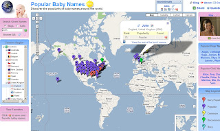
http://www.babynamemap.com/
Guy Davis has updated a very clear and fast map of popular names around the world.
"I wanted to send out a big Thank You to the Google Maps developers for creating a great tool and making it easy to build applications upon. Ever since the API was announced I've been looking for an opportunity to build something useful with Google Maps. When I found out that my wife and I were expecting our first child, my searches for popular baby names yielded a bunch of sites with boring old static HTML tables of data.
So instead, I've aggregated popular baby name statistics and show them on a Google Map which makes exploring this dataset a lot more interesting. If you're interested, check out the Baby Name Map at: http://www.babynamemap.com
Hopefully others will find the map useful as well. Keep up the great work on the API. I look forward to incorporating more new features into the map. "
From the Google Maps API forum and receiving lots of positive responses
New features are:
Floating windows
- Tab panes
- Dynamic trees
- Interactive data tables
- Flags of the world (tree directory)
"The new tree of countries makes it easy to navigate around the map and let me make use of some more interesting features of Google Maps. Now I need to update the map with some of the recent 2007 statistics."
Mapperz suggestion - Google Maps API with Google Chart API might work very well with this type of information, comparing names and statistics with location.
05 February 2008
London Low Emission Zone Maps
London Low Emission Zone Maps
The Low Emission Zone (LEZ) commenced on 4 February 2008.
Updated post (4th January 2012)
http://mapperz.blogspot.com/2012/01/low-emission-zone-map-london-uk.html
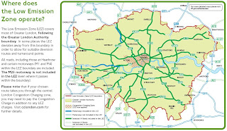
bigger than you thought?
Image source page 10
http://www.tfl.gov.uk/
"The Low Emission Zone (LEZ) affects older, diesel-engined lorries, buses, coaches, large vans (exceeding 1.205 tonnes unladen weight) and minibuses (over eight seats and below 5 tonnes)."
- The LEZ does not apply to cars and motorcycles.
- The LEZ applies to all roads and some motorways across most of Greater London NOT just the central London Congestion Charging zone
- The LEZ operates 24 hours a day, every day of the year which is different to the central London Congestion Charging hours.
- Your vehicle must meet Euro III standards for particulate matter to be driven within the zone or you will need to pay a £200 daily charge
** All maps in PDF format some are large file sizes (14mb+)
Labels: London, Low Emissions, Maps, Transport
04 February 2008
Track your Pizza (Map)
Track your Pizza from oven to door.
(when tracking becomes is a serious business!)
Domino's Pizza Tracker™ are permitting people to check the progress of their order to the nearest 40 seconds. By using their telephone number, customers can see the name of the person who took their order. They can see at the same time at which the pizza goes into the oven and the points at which it is removed, boxed, bagged and put onto a delivery bike\vehicle.
Image:
http://www.dominos.uk.com/media_centre/pictures.aspx
Domino's said the initiative followed a study of the emotions involved in awaiting a pizza which revealed that the "high" at the point of ordering was followed by a trough of anxiety.
"People have told us that anxiety sets in. They don't know if we've got their order, if we'll get it right, if it will arrive on time," said spokesman Tim McIntyre. "The tracker takes out the mystery involved."
http://www.guardian.co.uk/business/2008/jan/31/fooddrinks
With the new system, after an order is placed, the customer can go to dominos.com, click on the Pizza Tracker icon and follow the progress of the order. The site confirms that the order has been received, when the pizza is in the oven, when it's been boxed and when it's left the store.
http://www.usatoday.com/money/industries/food/
2008-01-29-pizza-tracker_N.htm
Bet your hungry too, now...
Labels: Custom Map, Domino's, Pizza, Tracker
02 February 2008
BBC Correspondents Map (v4.0)
update: 02/02/2008
The BBC Correspondents Map gets an Official blog post from Google Lat/Long
http://google-latlong.blogspot.com/2008/02/
all-news-thats-fit-to-map.html
1 February 2008 [v4.0]
- Moved up to new version - with shiny new photos and RSS links to the latest three articles on the BBC News website. Enjoy!
31 January 2008 [v3.2]
- Fixed layout bug in Firefox - thanks to it being entirely developed on BBC computers (and therefore in non-compliant Internet Explorer 6), it didn't display in browsers which are standards-compliant. This issue has now been fixed.
- Design change to move the black bar to the top of the page instead of the bottom.
30 January 2008 [v3.1]
- Fixed bug where correspondents based in bureaux were not displayed in the list.
30 January 2008 [v3.0]
- Changed info bubbles to tabs - one for each correspondent - in preparation for future features.
- Added links to BBC News search in order to find stories from the city, country and correspondent.
update: 31/01/2008
The BBC has taken a liking to this site:
http://www.bbc.co.uk/blogs/technology/2008/01/
bbc_reporters_mashed.html
"For more great news and maps mash-ups, take a look at this blog."
blog post by Darren Waters
Mapperz hopes that the BBC takes this on, as Geo-Spatial content is and will be a powerful media representation for BBC News.
maybe add latitude and longitude to RSS feed to get GeoRSS - http://www.georss.org
google already support this functionality
http://googlemapsapi.blogspot.com/2007/03/
kml-and-georss-support-added-to-google.html
"News has location and can be mapped." Mapperz
BBC Correspondents Map (v2.5)
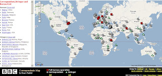
Version 2.5 of the BBC Correspondents sees new features based on user comments & feedback
A Great Mashup a few days old and moves on at a great pace...
Todays changes:
- A distinction between correspondents and stringers, as requested by users
- A full list of correspondents, stringers and bureaux, for users who have a name but not a location
- 4 RSS feeds for others to mash up
- Still to come: - More info on each correspondents- Links to correspondents' work on the BBC News Website from their location bubble
- More as I (Stuart) thinks of features
Version History:
29 January 2008 [v2.5]
Added a full, clickable list of correspondents, stringers and bureaux.
Introduced 4 RSS feeds which makes use of all the data.
Added an information link to explain more about the map.
Added this version history!
27 January 2008 [v2.0]
Added a comments link for feedback.
Added stringer distinction following feedback on the comments.
Databased the correspondent data up, to make it easier to update and in preparation for future features.
Slight redesign of the bottom bar to accommodate new feature links.
22 January 2008 [v1.2]
Added plenty of new correspondents to the map.
21 January 2008 [v1.1]
Added key to the map and the 'Jump to' section to go straight to a specific region of the world.
20 January 2008 [v1.0]
Map launched.
The Mapper - Stuart Pinfold, Media Co-ordinator, Newsgathering Traffic.
"works in the department (unique to the BBC) which intakes calls from every BBC correspondent and either records their despatches for use across all radio and TV outlets (including the World Service) or connects them to the TV or radio studio for live two-way interviews with the anchor."
The Map Link:
http://www.stuart-pinfold.co.uk/bits/corrmap/
(and look out for new features, see 'Version History')
other useful links:
http://googlemapsmania.blogspot.com/2008/01/google-maps-mania-links-for-2008-01-27.html
Labels: BBC, BBC News, Correspondents, Map, New Features, v2.5
01 February 2008
Nokia Internal vs External GPS
Nokia GPS Internal vs External
"The Nokia Bluetooth GPS Module LD-4W is for you if you’re looking for a navigation solution to send you effortlessly on your way. The lightweight, slim design makes this technology a great travelling companion" (AND DON'T HAVE AN INTERNAL GPS BUILT TO YOUR MOBILE PHONE)

Nokia GPS Module - it's light, small and gets good fixes with good battery life.
(though users with built in Internal GPS (i.e.N95, N82 etc might be surprised on this independent review...)
GPS Module LD-4W generously supplied by WOM World, not only did they just supply a bluetooth GPS but also a Nokia N95.
Mapperz likes thank them once again for this opportunity.
Nokia says you can...With a Nokia Bluetooth GPS Module LD-4W you can: Turn your mobile device into a navigator (but only if you sign up to Nokia Maps with Navigation)Explore with GPS features on Nokia Maps, or compatible software (correct)tap in an address to Nokia Maps and let voice-guided directions take you there (see note 1)
Take it along with the belt clip or suction cup (yes it comes with this though you might not ever use it)
Operate up to 11 hours on a single, fast charge (fast charge is 1 hour approx -came with a car charge but not a mains charger, though you can use the N95 mains charger.)
If on a long trip 11 hours or more your likely to need a double car charger or if not driving out on the mountains then a Power Monkey is recommended.
Tech Spec:
The GPS Module Tech spec:
SiRF Star III LT, 20 parallel channels, Weighs 31 g (It is small and super light
Up to 11 hours, continuous tracking (so your phone will need a charge by then
Stand-by up to 4 days (seems pretty good for a small device
Typical ± 5-10 m (seem better than that most of the time with 8 or more satellites)1 second refresh rate-30°C up to +70°
Cold start (when the Nokia Bluetooth GPS Module has been switched off more than 2 hours): up to approx. 45 seconds on average - TrueHot start (when the Nokia Bluetooth GPS Module has been switched off for less than 2 hours): up to approx. 2 seconds on average - True
DatumWGS84 (world geodetic system) only - (this seems the main stream format these days)
Supports most Nokia bluetooth phones - though you will need a map application or tracking application to use it.
Here is Mapperz tested Map Application List...
Tested with:Google Maps Mobile (with 'My Location')
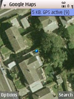
Google Maps used the fully capacity of the GPS Module and got 9 satellites
(less than 4 metres in true terms)
MGMaps (Internal GPS worked but failed to detect the paired bluetoothed GPS device)
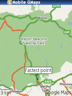
but does overlay kml from sport tracker
Yahoo Go! (beta 3) worked but no coverage maps of aerial for the UK (yet).
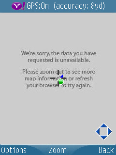
Maps24 (no gps tracking support but was 3D and has traffic alerts)
All required a internet link either wifi or more likely GPRS when out and about.
combine these mapping applications and you will get a first class mapping application
**Though Nokia Maps was pre-installed and map data loaded onto the memory card - but will use mobile/cell network if required.
Nokia Maps - worked in the same way as the internal gps device as expected.Nokia Sports Tracker (v1.7) worked well as expected.
Also told Mapperz to do a U-Turn on a dual carriageway!! though was traveling at speed.
The trial had almost ended from WOM World when Nokia Labs released Location Tagger (not used here) though see post.
Interesting the Nokia GPS device has 20 channels however their software seems only to support 5 channels (satellite fixes)
Google Maps Mobile used as many as 9 channels (max 12?) and seemed to get almost within a metre of 'my location' in several occasions.
*note to be fair the Assisted GPS and Network positioning was switched off as not all applications supported it.
Conclusion - if you have gps on your phone then you might not need to use this but if you want to take the strain off your mobile phone battery then you might consider this option, though remember that the bluetooth link will use battery life up too but not as much as internal gps chips.
Non-GPS phones (with bluetooth) that can install S60 mapping applications and want a nice little gps which does not need to be attached to the phone physically. This device is for you.
Price
Two options available:
The £59.99 version (just the module)
or the £169.99 version (includes Nokia Maps - but unsure if includes Navigation...)
Labels: Bluetooth, External, GPS, Internal, LD-4W, Maps, Navigation, Nokia


