->

25 August 2010

ArcGIS Explorer (Build 1500) Released

ArcGIS Explorer (Build 1500) Released

ArcGIS Explorer Build 1500 Released

View OpenStreetMap in 3D (2d is default) via basemaps
ArcGIS Explorer Build Open Street Map in 3D

ArcGIS Explorer Build import your data
Import your .shp, .kml, .gpx, .txt, .csv or even File Geodatabases!

"KML improved; KML handling has been improved in both 2D and 3D mode, and regionated KML is now supported in 2D mode. KML interoperability has also been enhanced; notes can be shared (exported) as KML and KML can be shared (exported) as layer packages or converted to notes. The KML file association can be set to ArcGIS Explorer.

Symbols (more); ArcGIS Explorer symbols have been updated to improve appearance in 2D and 3D modes. Symbol management tools have been enhanced with improved support for custom (user) symbols."

Buffering a point by 100km is possible via Analysis

ArcGIS Explorer Presentation Slide
Create driving directions, add slide (like screen grabs) to presentation - playback is full screen and glides to various screen grabs.

ArcGIS Explorer features new capabilities that enhance interoperability with the ArcGIS system and KML. These features include:

ArcGIS Online integration
Support for ArcGIS Explorer Online maps, including presentations and notes
Share (export) to layer package or KML
Create notes from features
Create notes from KML
Add data directly from Excel spreadsheets

Download here [98.4mb]:
Useful Links

Source:

Labels: , , , ,

06 January 2009

What's Coming in ArcGIS 9.3.1?

What's Coming in ArcGIS 9.3.1?

ArcGIS 9.3.1 is likely to improve the performance of dynamic map publishing and increases the sharing of geographic information.

High-Performance Dynamic Map Publishing

New faster rendering engine
  • Outperforms equivalent ArcIMS services.
  • Produces significantly better-looking maps.
  • Shortens map caching time.
  • Quicker, smoother zoom and pan.
* New Map Optimization toolbar in ArcMap helps you tune-up your map documents before publishing to ArcGIS Server.
  • Review and respond to errors, unsupported content, and warnings about items that will slow down your dynamic map services.
  • Preview your optimized map document and estimated rendering time.
  • Save your optimized map document to the new Map Server Document (.MSD)

Better Sharing of Geographic Information

* Better sharing of layers through ArcGIS Online
  • Layers can be packaged and published through ArcGIS Online Web services.
  • Layers can be found through a Web search.
  • Contributors can organize and control access to the layers they share.

Enhanced Support for Java Developers

* Ability to create the following extensions:
  • custom geoprocessing tools
  • server object extensions (SOEs) for ArcGIS Server
  • class extensions for custom behavior
  • custom renderer's for customized rendering of data
  • plug-in data sources
  • custom layers
* Support for Eclipse integrated development environment (IDE)
  • wizards to generate boilerplate code based on the developer's specification
  • autodeploy feature
**Upgrading to ArcGIS 9.3.1 does NOT require uninstalling ArcGIS 9.3**

Easy to migrate or work in mixed environments of ArcGIS 9.3 and ArcGIS 9.3.1 within the same organization since geodatabases, map documents, and APIs do not change.

When?
ArcGIS 9.3.1 is scheduled to be available in Q2 2009.

Source:
http://www.esri.com/software/arcgis/whats-new/whats-coming.html

Related:
http://webhelp.esri.com/arcgisdesktop/9.3/pdf/Whats_New_In_ArcGIS_93.pdf
(large pdf)

Existing Patches for ArcGIS 9.3 (SP1)

ArcGIS 9.3 SP1 (Desktop, Engine, Server) Geodatabase Replication System Version Patch
(December 17, 2008 - PATCH)

ArcGIS 9.x License Manager Update
(December 9, 2008 - PATCH)

ArcGIS 9.3 Service Pack 1
(November 24, 2008 - SERVICE PACK)

ArcGIS 9.3 SP1 (Desktop, Engine, Server) Topology Validation Patch
(November 19, 2008 - PATCH)

Military Overlay Editor 9.3 Service Pack 1
(October 17, 2008 - SERVICE PACK)

http://support.esri.com/index.cfm?fa=downloads.patchesServicePacks.listPatches&PID=43&FilterPV=457&FilterType=8%2C5

ESRI Wiki - System Requirements
http://wikis.esri.com/wiki/display/ag93bsr/ArcGIS+Desktop

Labels: , , , , ,

10 November 2008

ArcGIS 9.3 Service Pack 1 Released

Update [26/11/2008]:
Due to a couple of issues that have been resolved ESRI have updated
Service Pack 1 for 9.3
http://support.esri.com/index.cfm?fa=downloads.patchesServicePacks.viewPatch&PID=66&MetaID=1457
If you have already downloaded the service pack check the time stamps
(right click properties on the installer)

New Timestamp (SP1)
21 November 2008 20:13:08

Old Timestamp (SP1)
23 October 2008 06:27:52


If already installed service pack 1 then you can download the patches and install them to update the software rather than the long winded re-installing SP1
Topology Validation Patch
http://support.esri.com/index.cfm?fa=downloads.patchesServicePacks.viewPatch&PID=66&MetaID=1468


To Check the actual file causing the issue check
  • Under the \ArcGIS\Bin folder, right click the GdbTopo.dll file
  • Select Properties
  • On the Version tab, the File version for GdbTopo.dll should read: 9.3.1.1851
(note the issue with subscribers to Virtual Earth in ArcMap has yet to be resolved, so a workaround is mentioned in the comments)

ArcGIS 9.3 Service Pack 1 Released

ESRI have released the first service pack for ArcGIS products.
The list of improvements is huge due to the 'error reporting' function built into 9.3 software.

Here is the full list of fixes
http://gisupdates.esri.com/93sp1/ArcGIS/ArcGIS-93sp1-issues.htm

Mapperz top pick of fixes

NIM009383 - With ArcGIS 9.2 SP2 and higher, certain JPEG images cannot be loaded.

NIM006247 - Saving shape file edits more than eight times in ArcMap leads to slower and slower performance.

NIM033727 - Converting symbology to representation with the 'Features in current extent' option chosen does not complete properly.

NIM035106 - Application failure when using the SHAPE" field in the Select By Attributes command."

NIM036029 - Millimeter values are interpreted as points for size and width property overrides.

NIM036446 - Representation rules with identical internal identifiers can lead to data corruption.

NIM036971 - Exporting attributes to PDF results in incorrect values for fields using a number format.
NIM037410 - Exporting attributes to PDF is not preserving alias names for fields.
NIM037888 - Exporting attributes to PDF drops the value of a field called NAME when layer is using unique value renderer.

NIM037099 - When a line feature class is labeled using Maplex with the centered straight placement option and a label expression whose font tags differ from the symbol size, the labels are drawn offset from the line.

NIM037125 - Using buffer (in the editor or the Geoprocessing tool) fails on some very large input features.

NIM037580 - Crash due to lack of memory while building a spatial index for a complex polygon

NIM037814 - The Label Placement Optimizer algorithm does not work correctly when run inside a Composte algorithm

NIM037818 - Append does not work with feature set as target.

ArcGIS Desktop (ArcInfo, ArcEditor, ArcView)
ArcGISDesktop93sp1.msp 94 MB

ArcGIS Desktop Help updates
ArcGISDesktopHelp93sp1.msp 243 MB

Download the latest Service Pack from:
http://support.esri.com/index.cfm?fa=downloads.patchesServicePacks.viewPatch&PID=17&MetaID=1457

Labels: , , , , , ,

29 August 2008

ArcGIS 9.3 - Service Pack 1 - Announcement

ArcGIS 9.3 - Service Pack 1 - Announcement (updated)

(Due November 2008 - subject to changes and additions)

UK Users are still awaiting arrival of ArcGIS 9.3 from ESRI (UK)
(it arrived 25th September...)


Top Picks

NIM006247 - Saving shape file edits more the eight times in ArcMap leads to slower and slower performance. (an average user would save over 100 times a day).


NIM035569 - Network Dataset Build fails with File read/write error occurred" if more than 3 GB available RAM on the machine."(Windows can support 4GB)
NIM036572 - The Vehicle Routing Problem solver does not respect the network dataset hierarchy settings that the user has chosen for analysis.
NIM036573 - Out-of-memory error in Network Analyst crashes ArcMap.

NIM035799 - Using the repair geometry tool shifts feature-linked annotation to its default position when repairing the feature class it is linked to.
User would like to have the annotation remain in the position he [or she] set it.

NIM036029 - Millimeter values are interpreted as points for size and width property overrides.

NIM036030 - Representation masking creates unexpected results with advanced symbol level drawing.

NIM036694 - Using the Calculate Geometry tool in the attribute table produces incorrect results for calculating Hectares.


NIM037404 - The Microsoft Virtual Earth layer, available from ArcGIS Online, displays poorly when the data frame extent goes beyond -180 / 180.

NIM037690 - Remove duplicates deleting too many labels

More details from the PDF
http://downloads2.esri.com/support/downloads/ao_/ArcGIS_93SP1_Ann091608.pdf

To keep your ArcGIS up-to-date view
http://support.esri.com/index.cfm?fa=downloads.patchesServicePacks.listPatches&PID=43&FilterPV=457&FilterType=8%2C5
There are 3 patches for ArcGIS 9.3

Microsoft® Virtual Earth Patch (if have subscribed)
File Geodatabase SQL WHERE clause Patch
Adobe Reader® version 9 support

Labels: , , , , ,

10 July 2008

ArcGIS JavaScript Extension for the Google Maps API

Updated see red and blue below

ArcGIS JavaScript Extension for the Google Maps API
"The ArcGIS JavaScript Extension for the Google Maps API allows you to use your ArcGIS maps and tasks in the framework of Google Maps. There are many reasons to use this extension to expose your GIS data. Perhaps your audience already knows how to use Google Maps. Perhaps you're already familiar with the Google Maps API. Or maybe you just like the look and feel of the Google base maps."

Google Maps + Powerful GIS Analysis
ESRI GMAP API Directions with profile UK
Here is a Google Maps Direction Route - with the added profile of the route generated by ArcServer. (click image to see live example)

Here is another example of adding GIS capabilities to Google Maps.

ESRI Google Maps API DriveTime
Drive Time Polygons (1,2 & 3 minute driving time polygons) on the fly - overlaid on Google Maps. (click image to see live example)
Custom version http://mapperz.googlepages.com/DriveTime_ESRI_GMAP.html
(Drive Time only works in the US and Canada)

How is this geo-processing action created?

Create Drive Time Polygons - ArcGIS Model
Image source: http://globe5.arcwebservices.com/arcgisoutput/Network_ESRI_DriveTime_US/CreateDriveTimePolygonsDisks.htm

ArcGIS comes with Model Builder here geoprocessing functions Make Service Area Layer, Add Locations are just some of the core processing elements to create Drive Time Polygons.

This is the start of some serious and powerful tools that will and can be built on to 'enrich' the map user.
This provides them with detailed information that can be manipulated and customized to the users specifications on the fly.

Other possibilities at the Geo-Processing Service examples here
  • Display your own maps on top of a Google Maps base map.
  • Execute a sequence of GIS models and display the results in Google Maps.
  • Search for features in your GIS data and display the results on Google Maps.
  • Find addresses using your own address locator and display the result on Google Maps.
  • Display attributes from your GIS data on the map using the Google Chart API.
  • Allows others to add GIS functionality from your server as a Google Mapplet.
The future looks bright with GIS software companies taking on popular mapping API's

Please note there is an ArcGIS JavaScript™ Extension for Microsoft Virtual Earth™ version as well.

Reported by Google Map Mania from this Blog


Labels: , , , , ,

02 July 2008

ArcGIS 9.3 Web-based Help Now Available

update 02/07/2008 (7pm)

best and worst of the Help

Great to see the ArcGIS 9.3 Help up and running for all users now.

One thing I have noticed is the ‘Geoprocessing Center’ promised is either late coming or still out of date…(anyone know anymore?)

http://mapperz.blogspot.com/2007/06/esri-users-questions-answered.html

The best updated function so far is the 'Near' Command (ArcInfo Only)
Supporting Input points,lines, polygons and multipoint.
(a long time request)

http://webhelp.esri.com/arcgisdesktop/9.3/index.cfm?id=1273&pid=1268&topicname=Near_(Analysis)

old version only supported points as an input

http://webhelp.esri.com/arcgisdesktop/9.2/index.cfm?id=1111&pid=1107&topicname=Near_(Analysis)

Mapperz (via the James Fee 'Spatially Adjusted' Blog Comments

ArcGIS 9.3 Web-based Help Now Available


ESRI finally have updated their Support pages with 9.3 web-based Help

Quick picks

PDF Support (Acrobat 9.0)
(export with layers and attributes)

Postgres Connection
(via ArcSDE)

ArcGIS 9.3 Shortcuts

Animation of Data

And finally ArcGIS understands nominal scales!
(wiki)

so now One inch = 5 miles works. (thank you ESRI)


ESRI 9.3 Help now 'out of beta' and available for all to view and use.

New Features and Helpful 'error' messages have plain English explanations

http://webhelp.esri.com/arcgisdesktop/9.3/index.cfm?TopicName=welcome

The final build number for ArcGIS 9.3 is Build 1770
via Mandown (NZ)

Labels: , , , , ,

10 March 2008

ArcGIS 9.2 Service Pack 5 - Announcement

ArcGIS 9.2 Service Pack 5 - Announcement
The last service pack for ArcGIS 9.2 is due this month

Top Pick

NIM005856 - The Load Objects option does not work as expected.

NIM009501 - Windows NON-Administrator user cannot add a JPEG to an ArcGIS client such as ArcMap and ArcCatalog

NIM009632 - File geodatabase performance is poor when multiple computers whose names exceed 14 characters are accessing its data.

NIM010212 - The Multipart To Singlepart tool fails with polygon feature classes containing very thin parts

NIM011533 - ArcMap crashes after intersecting smoothed polygons

NIM012154 - Copy/Paste of a file geodatabase does not work correctly on Vista.

NIM013010 - Building a map cache from a compressed file gdb feature class can exhaust memory and lead to a crash.

NIM013246 - Representation symbology does not display correctly when a join is present

NIM013456 - Export to Shapefile fails when the underlying feature class contains a BLOB.

NIM031256 - Cartographic line symbols intermittently do not maintain CMYK color values when exported to EPS format from ArcMap.

NIM031622 - Export Dataset does not properly set the associated feature class in some cases.

Full List
http://support.esri.com/index.cfm?fa=downloads.patchesServicePacks.
viewPatch&PID=66&MetaID=1381

Labels: , , , ,

25 February 2008

What's New in ArcGIS 9.3?

What's New in ArcGIS 9.3?
ArcGIS 9.3 is expected to be available in the third quarter of 2008.
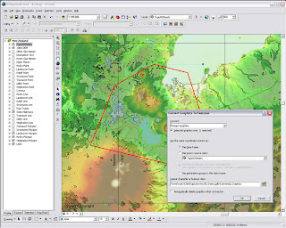
ArcGIS Desktop
The new Convert Graphics to Features dialog at ArcGIS 9.3
A new Convert Graphics to Features dialog has been added to allow you to create features by drawing graphics without using the editor.
For this function now go here ( Tools for Graphics and Shapes v. 1.1.76).


ArcGis 9.3 - Converting graphics to shapes

Pause Labeling
A new button in the Labeling toolbar lets you temporarily pause labeling to increase performance while you assemble the other layers in your map or do analysis. This saves you having to turn labeling off completely.

Manage Bookmarks
Bookmarks are much easier to access. You can also re-order and sort them, and export and load them between different data frames, maps and globes.

"Bookmarks are easier to access with the new Bookmarks pulldown menu. The 9.3 Bookmark Manager dialog lets you reorder bookmarks anyway you want and save bookmarks to a file for loading into other data frames, maps or globes. You can update the extent of an existing bookmark without having to recreate it. You can also save bookmarks into your My Places dialog so you can use the same bookmark in any map or globe you work with."

Data View and Layout Synchronised
Layer legends in the Table of Contents (TOC) and on your map layout automatically use lighter colors for symbols in layers that have transparency applied to them.

Full Table Joins
When you join tables, all of the field properties & field aliases, are now retained which makes working with joins much easier. You can now perform joins between layers or tables with definition queries defined and the definition queries are respected correctly.
There is now a toggle between showing field name aliases and showing the underlying field names. You can also sort a table on multiple attributes.

Full Identify Attributes
Identify window, the dialog will now respect all the field properties, such as primary display field, field aliases and field visibility, of any layer or table in your map that represents that related data in your map. Also when you identify a feature, you can now immediately launch the properties dialog and attribute table of the layer that the feature belongs to directly from the Identify window. This saves you having to look for a specific layer in the Table of Contents and is particularly useful when your map contains a large number of layers.

Address Geocoder and Reverse Geocoder
The new Address Inspector lets you click on a map to get the nearest address to any location
A new reverse geocoding tool called the Address Inspector lets you click on a map to get the nearest address to any location, and you can add that address to the map as a label.

Export & Clip Raster Data
It is now easier to export raster data. A new option within the Export Raster Data dialog in ArcMap lets you clip the output raster to the extent of the selected graphic(s) on your map.

Relative Scale Bar (1 in = 5 miles)
In 9.3 you can customize the scale control so that scales are always reported in relative format.

There is a now way to display map scales throughout the ArcMap user interface in relative format, such as 1 in = 5 mi, in the units of your choice, making scales easier to understand.

Double click Layer File (opens ArcMap)
Layer files are now registered with the ArcGIS Desktop applications. Double-click LYR files in Windows Explorer, Outlook, Windows Desktop to add them into your current map or launch ArcMap if it is not already running.
You can also click on LYR files presented on Web pages to add them into your maps, which provides internet data publishers with a simple way to provide ArcGIS Desktop users with access to their map services.

New Cartographic Tools
WYSIWYG (What You See Is What You Get) editing of cartographic representations has been added. When moving representations on a map, you'll be able to see the symbology instead of the wireframe outline so that you can better see how the edit will impact your map.
The new representation marker dispersal tool reduces the complex one-to-many relationship to a simple dynamic map

New Geoprocessing Tools
have been added to help with cartographic production. Disperse Markers has been added to allow you to spread representation markers apart which are coincident or nearly coincident. The new 'Set Representation Control Points at Intersect tool', you can now add a control point where coincident features share vertices.
New geometric effects
Move, Rotate, Scale, Wave, Tapered Polygon, and Regular Polygon.

*When exporting to XML, there is more information available about cartographic representations & rules.

Enhancements to Geoprocessing.
Within ModelBuilder, variables are more flexible in models and the 'Feature Record Set' and 'Record Set Controls' have been improved. More control over your geoprocessing model's parameters such as if a parameter is optional or required and what variable values are acceptable as inputs.

Script tools can now have multi-value outputs. The Results Window now shows environment settings. The Python scripting experience has also been improved. Python can now be run within an ArcGIS process.

**Error messaging has been revamped to make errors more descriptive and better linked to the help system. Messages are now standardized across all products, including ArcGIS Desktop extensions. These new, more informative messages will make it easier to build scripts and models.

Tool progress
messaging has also been improved and now more accurately displays actual progress. Not only will you be able to see how long an operation will take, but you'll know if the operation is proceeding as planned and not in some unknown state.

The 'Near' tool has been made more flexible and will now work with more than points and lines. It will perform calculations to all features within a given search radius. The ability to join to the closest feature has been added to the Spatial Join tool, making it easier to merge attributes.

New Spatial Statistics Tools

A new 'Generate Spatial Weights' tool in 9.3 gives you a new way to model spatial relationships. Its use results in a spatial weights file that is re-usable, editable, and sharable. A new 'Ordinary Least Squares Regression' (OLS) tool help you decide if your data is suitable for analysis using a global model that is the most commonly used regression statistic. The new 'Geographically Weighted Regression' (GWR) tool uses a local model for regional variations and helps you understand how processes vary of space.

ArcGIS Server
  • Improved performance
  • On-demand caching and improved caching geoprocessing tools will allow you to create faster mapping services.
  • New image services will let you quickly publish imagery that is optimized for the Web.
  • Better diagnostics
  • Precise logs will enable you to easily identify bottlenecks and points of failure and improve your installation and configuration experience.
  • New options in Manager will make it easier for you to secure Web services and Web applications
More documentation
Major additions have been made to the online help and SDK documentation.

A new ArcGIS Server Resource Center brings together the set of online resources to help make you successful including blogs, samples, and best practices information.

Mapping API
ArcGIS Server 9.3 also introduces several important new features:
New REST and JavaScript APIs
These APIs will dramatically simplify your development experience and enable you to deliver fast and user-friendly mashup GIS Web applications.

***The JavaScript libraries will also let you embed ArcGIS Server maps, geocoding, and geoprocessing services into Google Maps API and Microsoft Virtual Earth API.

OGC and industry standards
New Open Geospatial Consortium (OGC) services support
Additional support for OGC and industry standards, such as Web Coverage Service (WCS), Transactional Web Feature Service (WFS-T), and KML 2.1, will improve your ability to integrate with virtually all the commonly accepted GIS and IT standards.
New PostgreSQL support - thank you ESRI! :)
(This gives you the ability to store and manage spatial information in this open source database system without ArcSDE.)

"The 9.3 release of ArcGIS Server represents a complete and integrated server-based GIS with significant quality enhancements and several new features that will make it even easier for you to create and manage end-user applications and services for spatial data management, visualization, and spatial analysis."

The Geodatabase
The geodatabase continues to be the common data storage and management framework for ArcGIS. At ArcGIS 9.3, the geodatabase offers improved spatial data management and enhanced capabilities for integration with enterprise systems.

ArcGIS 9.3 geodatabase enhancements include:
  • Raster data management. New geoprocessing tools make the transfer of unmanaged raster catalogs (in Microsoft Access personal geodatabases and file geodatabases) from one location to another much easier
  • Geodatabase replication. Microsoft Access personal geodatabases and file geodatabases can participate in one-way replication as child geodatabases
  • ArcGIS 9.3 allows for more detailed logging of geodatabase replication activity.
Direct Connect backward compatibility (clients will be happy)
ArcGIS 9.3 clients can make direct connections to pre-9.3 enterprise geodatabases (e.g., 9.2, 9.1, and 9.0).
Backward compatibility allows easier implementation of phased migration strategies for new ArcGIS releases.

Versioned editing
The Merge Geometries option enhances conflict and reconcile management.The Version Changes Viewer tool allows a version to be compared with an ancestor version without performing a reconcile operation.

Support for PostgreSQL (Open Source DBMS)
Enterprise geodatabases can be implemented on PostgreSQL with full support of the geodatabase data model.Vector geometry is stored in the ESRI spatial type.
PostGIS Open Source spatial type is supported.

Support for SQL Server 2008

The SQL Server 2008 release will introduce two spatial types: Geography and Geometry. These will be supported in enterprise geodatabases implemented on SQL Server 2008.

Operating System
New 64-bit platform support
Enterprise ArcSDE technology is now available as a native 64-bit application for Windows and Linux.

Source: ESRI (Mapperz edited for this post)

Labels: , , , , , ,

04 January 2008

Graphics and Shapes Extension for ArcGIS

Graphics and Shapes Extension for ArcGIS 9.2

11/08/2008
A few extra functions have been added:
  • Added “Build Polygon” function
  • Added Polyline Azimuth options to “Calculate Geometry” tool.
  • Multiple minor edits to code and manual, described in full in manual.
  • Build 1.1.76 (January 10, 2008) Corrects a bug where the Spheroidal Length was being written to the wrong field.
version 1.1.76
http://arcscripts.esri.com/details.asp?dbid=15376

"Description: This extension includes a large suite of tools for calculating geometric attributes of vector features and for selecting and naming graphics. All tools are available at the ArcView license level."

Jeff Jenness Graphics Shape Tools for ArcGIS Results
Cleaner and Faster than conventional 'ESRI' Toolsets (and a progress bar that works)


Jeff Jenness Graphics Shape Tools for ArcGIS
Simple layout of functions - much better than those geoprocessing tools in the toolbox you can never find the name for.

Tools for Graphics
Graphic Elements to Shapes
Select Graphic Elements by Type
Select All Graphic Elements
Unselect All Graphic Elements
Flip Graphic Element Selection
Zoom to Selected Graphic Elements
Name Graphic Elements
Tools for Shapes
Convert Polygons to Label Points
Convert Shapes to Centroids
Convert Shapes to Spherical Centroids (detailed method explained in PDF)
Convert Shapes to Vertices
Convert Polylines to Polygons
Convert Polygons to Polylines
Split Multipart Features
Combine Features
Calculate Geometry


"Jeff Jenness is an independent GIS consultant specializing in developing analytical applications for a wide variety of topics, although he most enjoys ecological and wildlife-related projects. He spent 16 years as a wildlife biologist with the USFS Rocky Mountain Research Station in Flagstaff, Arizona, mostly working on Mexican spotted owl research. Since starting his consulting business in 2000, he has worked with universities, businesses and governmental agencies around
the world, including a long-term contract with the United Nations Food and Agriculture Organization (FAO) for which he relocated to Rome, Italy for 3 months. His free ArcView tools have been downloaded from his website and the ESRI ArcScripts site over 190,000 times."

Full and comprehensive documentation (in PDF Format)
http://www.jennessent.com/downloads/Graphics_Shapes_Online.pdf

Source:
Jenness, J. 2008. Tools for Graphics and Shapes: Extension for ArcGIS. Jenness Enterprises.
Available at: http://www.jennessent.com/arcgis/shapes_graphics.htm

Labels: , , , , ,

12 December 2007

Microsoft Windows Update Kills ArcGIS Help

Microsoft Windows Update Kills ArcGIS Help

"ESRI® announces the ArcGIS 9.2 Desktop Help Search Patch. This patch solves an issue where the search tab in ArcGIS Desktop help becomes inoperable. We recommend all ArcGIS Desktop 9.2 users download and install this patch at their earliest convenience to ensure the highest quality experience when working with ArcGIS Desktop 9.2"

BBC 's Little Britain - Computer Says No!

    NIM013534 - AnswerWorks search in ArcGIS Desktop Help will stop functioning after a Microsoft Windows Update.

    Description

    The ArcGIS Desktop help uses a 3rd party search engine called AnswerWorks. Microsoft has released a security update to Internet Explorer affecting the Desktop help search to become inoperable. This patch resolves the issue of the search engine being non functional by updating the 3rd party search engine.


NOTE:
ArcGIS Desktop 9.2 Service Pack 4 must be installed before you can install this Patch.
If you have installed client setups from a shared Network Administrative ArcGIS Desktop setup, this Patch must be applied to all client installations.

Download the Patch
http://support.esri.com/index.cfm?fa=downloads.patchesServicePacks.viewPatch&PID=43&MetaID=1357

Labels: , , , , ,

30 November 2007

GeoWizards 9.7 for ArcGIS

GeoWizards 9.7 for ArcGIS
One of the best all round third party extensions you can get for ArcGIS - lots of functionality is *Free*

"A collection of powerful data manipulation, topology and surface functions for ArcGIS "

GeoWizards 9.7 TIN to Features Elevation

New functions are:

Map To Google Earth
Feature Class to Google Earth
Import from Google Earth
Polygon Characteristics
Perpendiculars from points to polylines
ESRI TIN To PolygonZ
Shape To ShapeZ
Point To Multipoint
Disperse Points
Random Points On Polylines
Random Points In Polygons

GeoWizards 9.7 Import or Export to Google Earth (KML)

* New method (number of vertices) included in the Split Polyline function
* Create Centerlines and Aggregate Polygons functions added to the version for ArcGIS 8.x.
* Scripting and toolbox implementation of the Ungenerate function added.
* Two new options added to the Features To Bounding Rectangles function.

Improved is:
* Improved performance and ability to handle large datasets. Functions affected:
o Build TIN
o Build Thiessen
o Aggregate Polygons
o Create Centerlines
* The Clean Dangles function allows user defined Fuzzy/Cluster tolerance to be assigned - better user control over the function.
* Improved error reporting
* **Several Functions improved to handle datasets with Z or M values. In the previous versions the input Z(M) values were dropped .
Functions affected:
o Clean Polygons
o Clean Polylines
o Erase
o Batch Erase
o Clean Dangling Nodes
o Clip
o Batch Clip
o Advanced Merge
o Symmetric Difference
o Merge Layers
o Split By Location

Bugs fixed:

Point Intersection function produces incorrect results if a polygon dataset that have polygons with holes is used.

A licensing problem in the Scripting and ToolBox implementations in ArcGIS 9.0.

***Inability of some of the functions to handle correctly datasets containing true Arcs. Functions affected:
Build Polygons
Clean Polygons

***Some of the tools of the ToolBox implementation produce an Windows error if used within a script run from the command prompt. The results are derived, but the tool breaks up the script. Tools affected:
o Clean Polygons
o Clean Polylines
o Clean Dangling Nodes
o Clip
o Erase
o Advanced Merge
o Symmetric Difference
o Thin Points
o Aggregate
o Interpolate Contours
o Create Centerlines
* Point Angle And Position function fails in some cases when the source paint dataset is a PGDB feature class
***Several functions fail if the output is File Geodatabase:
o Points To Polylines
o Points To PolylinesZM
o Points To PointsZM
o Points To Polygons
o Points To PolygonsZM
o Batch Drop Z(M)
o Batch Clip
o Batch Erase

** Only the version for ArcGIS 9.0 and above
*** Only the version for ArcGIS 9.2

One of the best and most useful functions that this extension has is 'Create Shapefile' inside ArcMap to create a new point, line or polygon.

For more information and to download this extension go to:
http://www.ian-ko.com/

Labels: , , , ,

16 November 2007

ArcGIS 9.2 Service Pack 4 Soon

ArcGIS 9.2 Service Pack 4 Out Now

So here is the ESRI Service Pack 4 Link
http://support.esri.com/index.cfm?fa=downloads.patchesServicePacks
.viewPatch&PID=17&MetaID=1351

176mb for the ArcGIS Desktop SP4 installer
379mb for the ArcGIS Desktop Help

Nothing new but lots of bug fixes....

Mapperz top picks...

  • NIM002728 - GeoTIFF files created with the ArcMap Export Map function should contain spatial reference information in addition to the currently encoded position and transform.
  • NIM007791 - Append Annotation tool in ArcToolbox creates duplicates of all fields for each annotation feature class being appended.
  • NIM007843 - Text symbol halos often fail to draw correctly, or they drop out.
  • NIM008760 - File geodatabase raster catalogs with managed imagery crash ArcGIS Engine applications.
  • NIM009820 - Graphic elements added using the Insert Picture command may have some pixels turn black when the MXD is saved with elements in "Save picture as part of document" mode. Parts of the picture may also turn black during export to PDF or other vector graphics formats.
  • NIM010025 - Closing the map when multiple editors are editing a version concurrently does not save edits when requested.
  • NIM011119 - Browsing for PMF (ArcPublisher) files will no longer cause the computer to freeze.
  • NIM011379 - When switching from the Maplex labeling engine to the standard ESRI labeling engine, the View Unplaced Labels function stops working for the standard labeling engine, and any previously displayed unplaced labels are removed.
  • NIM011521 - The ExportCAD function now creates a new PRJ file if overwriting an existing CAD file that already has a PRJ file, along with the CAD file.
If you have a spare 15-20 minutes you can read the full list of bug fixes.
http://support.esri.com/index.cfm?fa=downloads.patchesServicePacks
.viewPatch&PID=17&MetaID=1350

ArcGIS 9.3 (with Postgres support) out Early Next Year 2008

here is a good article on ArcGIS 9.3 new features (pending after beta)
http://www.directionsmag.com/article.php?article_id=2494&trv=1

Look for to this 'Geoprocessing' where users can share their geoprocessing models

One is described here 'Regression Analysis'
http://blogs.esri.com/Info/blogs/ucblog/archive/
2007/06/20/eoprocessing-advancements
-provide-greater-scientific-analysis.aspx

Labels: , , , ,

12 July 2007

Batch Geocoder to ArcGIS

Batch Geocoder to ArcGIS Tutorial

(for getting Latitude and Longitude for Postcodes and Addresses)

Now this requires a bit of prior knowledge on Geocoding and Basic GIS Skills

Thanks to Google for providing the UK Geocoding in the Google Maps API

Have a set of addresses or postcodes ready.

*but if you intend to do a huge amount of geocoding it's politer to have your own api key rather than using others

example postcodes used in this example (can be 5 can be 50,000)
AL1 1HH
AL1 1HJ
AL1 1HQ
AL1 1HR
AL1 1PW
AL1 1RZ
AL1 1SD
AL1 1SE
AL1 1SF
AL1 1SG
AL1 1SH
AL1 1SN
AL1 1SQ
AL1 1ST
AL1 1SW
AL1 1XU

or use Addresses like
10 Downing Street, Westminster, London, UK
(can be your own list of clients, businesses, store locations etc)

where do they go?

Either
http://www.batchgeocode.com/
or
http://www.gpsvisualizer.com/geocoder/

(for your own version flow instructions at bottom of gpsvisulizer page)
or
http://www.wotton.org/map/batchgeo.html
(recommended for ease of use)

batch geocoders to gis
Copy and Paste in the top light blue box, wait until the alert shows the copy and paste from the bottom green box into a New Spreadsheet.

batch geocoders - pasting

Paste into Open Office Calc or Excel with the correct delimiters.

batch geocoders pasting add decimals

Make the pasted lat and lng's six figures in decimal places
save the spreadsheet


batch geocoding xls arcgis
Add the Spreadsheet to ArcGIS (will need a double click if more than 1 worksheet is in the file)

Use WGS84 Geographical Projection to set the Excel Spreadsheet into the correct projection

Use Add XY Data add the data by Lat/Lng and an event theme will be created, this can be exported out as a shapefile or geodatabase.

Important Note: Geocoder Accuracy
ALWAYS check Accuracy - this shows that the all Geocoders have limitations
This compares Codepoint (accurate to 100m) to the Google Geocoded Postcodes and there is approximately +/- 150 metres error in their location.

batch geocode check accuracy in GIS

Blue is OS Codepoint in Geographic WGS84
Red is the Google Geocoded Postcodes
(used for a comparison only!)


The method is useful for small datasets, depending on your use.
It could be easily changed to load the geocoded data into a MySQL or Postgres databases for spatial retrieval and added back on to web mapping applications.

Yahoo does Geocode UK Addresses (in some cases more accurate) but it's limitation is that it can only be used on it's on Mapping API and the Geocoder is limited to just 5,000 requests per 24 hours.

For Manual Geocoding
Please use the Official Example:
http://gmaps-samples.googlecode.com/svn/trunk/geocoder/singlegeocode.html

Labels: , , , ,

12 June 2007

ESRI Users Questions Answered

ESRI Users questions answered from ESRI International User Conference 2007

ESRI Website

Mapperz Mixed Pick from http://gis2.esri.com/library/userconf/index.html


When will ESRI certify support on Microsoft’s Vista operating system?
We will complete our testing and add support for the Microsoft Vista operating systems in the third quarter 2007 for ArcGIS Desktop 9.2. We will support all products on Windows Vista at the ArcGIS 9.3.

NOTE: Due to some issues with Vista, several patches from Microsoft will be required in order to run ArcGIS under Vista.

What is the status of ESRI’s support for running ArcGIS on 64-bit operating systems?
ESRI is currently performing certification testing for ArcGIS Desktop 9.2 to support 64-bit processors. This will be delivered with service pack 3 in July.


What is ESRI doing in ArcGIS to make it easier for users to share geoprocessing models and best practices?
ESRI will publish a new Web site named the Geoprocessing Center to coincide with the ArcGIS 9.3 release in an effort to promote the sharing of geoprocessing models and scripts among the ArcGIS user community. This new resource center is part of the ESRI support site. By openly sharing these models and scripts, we can help each other learn and apply geoprocessing for solving many types of problems. ArcGIS 9.3 will make it easy to publish models to, as well as search for and download models from, the Geoprocessing Center.


When will ESRI support better handling of graphical exports of large format maps (72 x 55 inches and larger)?
The next major release after ArcGIS 9.3 will include a new plotting and graphic display system that will significantly increase display performance and support large format map export as a primary capability.


Can you improve the performance of the “Near” spatial analysis tool?
(Requested many times to ESRI UK - you try using 'near' with 28 million addresses)

Yes, ArcGIS 9.3 will include a new approach for performing proximity analysis that substantially increases the performance of the Near tool. New functionality will be provided that calculates the distances between and among various features (points, lines, and polygons). The output of this function will be a new "near table" that can be subsequently used for various kinds of spatial analysis (e.g., spatial statistics).


What is ESRI doing about the speed of ArcMap?
In the next major release after ArcGIS 9.3, ESRI will implement a new display pipeline into ArcGIS that will radically improve display performance and scalability.


Microsoft is developing a spatial type in SQL Server. Will ESRI be supporting this?
(codenamed 'Katmai' will be SQL Server 2008 with Spatial Database Support.
This manages any type of data from relational data to documents, geographic information and XML.)

Yes, ESRI is working closely with Microsoft and will release support for this spatial type as a standard part of ArcGIS clients (direct connect) and ArcGIS Server (ArcSDE gateway). This capability will be supported with ArcGIS 9.3. We will coordinate the timing of the release of this functionality with Microsoft’s release schedule.
Microsoft SQL Server 2008 Spatial
More info on Microsoft SQL Server 2008
http://www.microsoft.com/sql/prodinfo/futureversion/default.mspx

Labels: , , , , , , , ,

13 February 2007

ArcGIS 9.2 Simplify Polygons

ArcGIS 9.2 Simplify Polygons (Generalization)

"Simplifies a polygon by removing small fluctuations or extraneous bends from its boundary while preserving its essential shape."

Simplify Polygon (Data Management) (ArcInfo only)

The process produces two output feature classes, a polygon feature class and a point feature class. The polygon output will stores the simplified polygons. The point output will store points, if any, representing polygons that are collapsed to zero-area.
This point feature class is used to transfer the attributes of the polygon.

Generalize Polygons Original
The process is hidden but the polygon is transfered to a line then the simplification/generalization is applied to a line. The new polygon is the result of the simplified lines rebuilt into polygons with the point used as the attribute container between the process.


Generalizing Polygons ArcGIS 9.2


Generalizing Polygons ArcGIS 9.2 Result
Pre ArcGIS 9.2 Generalizing Polygons
This method was created in ArcGIS 9.x prior to 9.2 using this exact method.
note the Append tool is used. This is because a Geodatabase template (with pre-defined Subtypes) is used. This method deletes all features then add (appends) all new generalised features back in to the correct subtypes. Therefore maintaining database control if topology rules are to be applied.
Tip: Save out Topology rules (.rul) delete all topology as this prevents editing feature classes that have topology. Load topology rules back into the Geodatabase and validate to complete the process.

Web help
Simplifying and smoothing features

Mapperz uses this frequently

Labels: , , , ,

30 January 2007

Spatial Join (Analysis) Returns to ArcGIS

Spatial Join returns to ArcGIS 9.2, This function has been missing since ArcView 3.x, which is a much needed function in the GIS field.

This geoprocessing function is found in Analysis Tools>Overlay>Spatial Join

Please note this function is not Spatial Join by attributes as in previous versions of ArcGIS nor the Join on the tables.

This Spatial Join (Analysis) is by the features location.
"Creates a table join in which fields from one layer's attribute table are appended to another layer's attribute table based on the relative locations of the features in the two layers."

There is are three very powerful new functions also available in this example.
This quick example is setting up the Spatial Join selecting the Rivers that fall with different countries and assigning the river with a country name using intersect
.
Data is from the ESRI DVD World Data that was shipped with ArcGIS 9.2

Spatial Join (Analysis) Window
The spatial join using one to many on intersect features


Spatial Join (Analysis)in Model Builder
Using the Model Builder to create this process (yes there are new funky shapes in model builder)

Spatial Join (Analysis)in Iteration Mode Model Builder

Model of Spatial Join but with 3 Iterations using values in the search radius (10, 20, 30 kilometres are examples)

The batch can be created by right clicking the saved model and selecting batch.
More info on batch set ups here

Labels: , , , , ,

24 January 2007

ArcGIS 9.2 is Delivered to UK Users

ArcGIS 9.2 is Delivered to UK Users

UK Users can finally get there hands on ArcGIS 9.2 (Arc/Info, ArcEditor and ArcView)

Though a few surprises lurk:
  • DVD only (Lots of CD only users beware)
  • No Service Pack 1 included
  • Documentation is in PDF format (no hardcopy unless you print them)
Though there is one useful leaflet called ArcGIS Desktop - A Selection of Time-Saving Tips and Shortcuts (This will be put to the test).

Cartographic Representations part 5 coming soon.

Mapperz recommends installing the updated version of the Service Pack1
updated on the 9th January (43.7mb)

Also use the ArcGIS 9.2 Help Web Version
as is more up-to-date than the desktop installed version

Source: Mapperz

Labels: , , , , , ,

17 January 2007

All ESRI Downloads in One Location

Some of latest Free downloads for GIS from ESRI in one location.

Software(Free)

ArcExplorer 9.2 (bulid 350) (43.4 MB)
ArcExplorer 9.2 (AIX) arcexplor92_aix.tar
ArcExplorer 9.2 (HP-UX) arcexplor92_hp.tar
ArcExplorer 9.2 (Linux) arcexplor92_linux.tar
ArcExplorer 9.2 (Solaris) arcexplor92_solaris.tar
ArcExplorer 9.2 (Windows) arcexplorer92_windows.zip

ArcReader 9.2 (175 MB)
ArcReader 9.2 Linux arcreaderlinux92.tar
ArcReader 9.2 Solaris arcreadersolaris92.tar
ArcReader 9.2 Windows arcreader92.zip

More Downloads

Labels: , , , ,

11 January 2007

MapSpeller™ for ArcGIS® Extension

MapSpeller is a spatially-smart map spell-checker.

MapSpeller for ArcGIS Desktop
Image: Edgetech America, Inc

The MapSpeller for ArcGIS extension is for all ArcGIS Desktop users who want to avoid the embarrassment, delays and costs of typos on their maps. Before printing, MapSpeller quickly checks for, and suggests corrections to, spelling errors in and around GIS maps using patent-pending processes. Simple to install and easy to use, MapSpeller is an ingenious and effective tool that will quickly pay for itself by saving users the cost of expensive reprints.

Currently
Edgetech America, Inc.has filed for a U.S. patent for, and reserved international filling rights to, a GIS map spell checking and correction system.

As we all make the odd spelling mistake. Don't we?
Hope that more than just US English is Supported.
Mapperz just needs a dyslexia corrector


Labels: , , ,

29 December 2006

ArcGIS 9.2 Service Pack 1 Released

For the select few that have ArcGIS 9.2 installed the Service Pack 1 (of?) is available.
It will not solve ArcGIS 9.2 crashing, but hopefully it will, a little less often.

List of files changed here (notice the KmlLayer.dll and PDFExporter.dll to name a few)
Top Tip - Make tea or coffee before reading the links above.

Note: You must download separate ArcGIS Desktop (44MB), ArcIMS(29.3 -148 MB) and ArcSDE(7-14MB) service packs.

If unsure of existing service packs/patches use the service pack checker.
Install as an Administrator

ArcGIS Server for the Java Platform is not yet available.

One not listed is ArcGIS Explorer?

Labels: , , , , , ,