->

15 March 2010

CycleStreets.net Easy Cycle Routes Maps

CycleStreets.net Easy Cycle Routes Maps

Some really nice implementations making cycle route planning much easier and user friendly.
CycleStreets.net Namefinder Geocoder

As well as adding postcode search support recently, CycleStreets.net this week upgraded the general street/place finding system geocoder. Default map is Open Street Map (Cycle Map) but Google Streets and Google Satellite are available via the map controls. Image source: http://www.cyclestreets.net/blog/2010/03/14/geocoder-upgraded/

Some tips for quicker searches are:

  • If the map is zoomed out, ideally include a city name as well, so that it knows what area to look in
  • If you do specify a city, add a comma before it, e.g. “York Street, Cambridge” rather than just “York Street Cambridge”
  • Note that lower-case text works the same as Capitalised Text.
f you decide to follow the suggested journey below please take extra care on unfamiliar sections - proceed at your own risk as route quality cannot be guaranteed.

Journey can be customised into 3 types of cycling
  1. Fastest route
  2. Balanced route
  3. Quietest route

CycleStreets.net Route with Photo

Gradient, Wiggliness and number of Traffic lights are also factored in for your journey on your bike.

Example:
Quietness: 83 % Quiet (shhh at the back!)
Traffic signals:at junctions
Wiggliness: 0%. (like it)
Specific Leaving 11.09am, Arriving Times 11.29am.

CycleStreets.net Route with UK Streetview
Now the UK has Full Google Streeview coverage it can be added to almost any cycle route you now plan.

Plan your route on bike, tandem, trike by using this mapping site:

http://www.cyclestreets.net/

Very good work
For more information and details on the technological (gecoder) aspects visit
http://www.cyclestreets.net/blog/

Please Note:
CycleStreets beta: Not all areas have complete cycle route data yet. CycleStreets is UK-wide with over 1500+ locations http://www.cyclestreets.net/area/

Labels: , , , , , , ,

24 January 2010

Google Geocoder Suggests (Esa's Experiments)

Google Geocoder Suggests (Esa's Experiments)

Google has had the 'suggest' option on the main site for a while, yet when you go to the maps you need to know your destination, now you can get help with a geocoder extended with a suggest.

Ahead of the game with Google Map API is Esa with his impressive well thought out experiments.

Google Esa Geocoder Suggests
The example above typing in Bri... suggests 10 locations in Google's Geocoder that are located.
Very clean,very fast and extremely useful.
http://koti.mbnet.fi/ojalesa/boundsbox/geocode_basic_3.htm

Without a Search button - http://koti.mbnet.fi/ojalesa/boundsbox/geocode_basic.htm

*Geocoders are not perfect, they should never be trusted, they are as only good as the accuracy of the original data they were derived from.

Custom Map Types:
Custom Map Types with Geocoder
Custom map Types - here Google Maps with Traffic is synchronised with OpenStreetMap
  • Image map type, like OpenStreetMap tiles in the example page
  • Image overlay map type, like the Traffic tiles in the example page
  • Non-image tile based map type
http://koti.mbnet.fi/ojalesa/v3/osm_dual.htm

Image Map Type behaves just like the standard map types. Image Overlay tiles are displayed on top of the Image Map Types.
The non-image map type makes it possible to create tile layers with SVG, canvas or any html elements
.

Geocoder with Bounding Box - Extent
The v3 Geocoder has extent (Bounding Box) optional, Esa makes this visual with his Bounding Box Page, can be useful narrowing search requests within a specific area.

http://esa.easypagez.com/v3boundsbox/

Sources:
http://koti.mbnet.fi/ojalesa/exam/index.html
(many other examples too)

http://nuppineulat.blogspot.com/ (
Finnish)
http://apitricks.blogspot.com/ (English)

Many thanks to Esa for creating the examples and making them available to budding developers.


Labels: , , , , , ,

08 January 2009

Google API Geocoder Updates [ExtendedData]

Google API Geocoder Updates [ExtendedData]

Update 13/01/2009

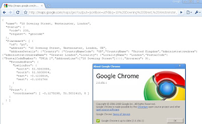
Google chrome users will be happy to know if you update to version (2.0.156.1)
your get the bounding box response from the Google Geocoder.


How to get Google Chrome 2 (Beta)?
http://dev.chromium.org/getting-involved/dev-channel

---------------------------------------------------------

Google Developers have been promising this for a few months now but finally it has made it to the real world. The Bounding Box has made it to the geocoder.

What is new?
Google Maps API Group has a suggestion/requests/issue tracker and one was for the bounding box (SW Corner and NE Corner) to be return when a geocode is sent to the google geocoding servers

Now you get the bounding box not just the centre coordinates

http://maps.google.com/maps/geo?output=jsonl&oe=utf-8&q=10%20Downing%20Street,%20Westminster,%20London&gl=uk&key=ABQIAAAA5heAddVpewIi0Vy-FvLfBBQ6SKP0Jc9Qt0dvx

now returns:
{
"name": "10 Downing Street, Westminster, London",
"Status": {
"code": 200,
"request": "geocode"
},
"Placemark": [ {
"id": "p1",
"address": "10 Downing Street, Westminster, London, UK",
"AddressDetails": {"Country": {"CountryNameCode": "GB","CountryName":
"United Kingdom","AdministrativeArea": {"AdministrativeAreaName":
"Greater London","Locality": {"LocalityName": "London","PostalCode":
{"PostalCodeNumber": "SW1A 2","AddressLine":["10 Downing Street"]}}}}
,"Accuracy": 9},

"ExtendedData": {
"LatLonBox": {
"north": 51.5063886,
"south": 51.5000934,
"east": -0.1238814,
"west": -0.1301766
}
},
"Point": {
"coordinates": [ -0.1270290, 51.5032410, 0 ]
}
} ]
}

Why the fuss?
Well now this extra [Extended information] can be used to set zoom levels for your map.

"Now, in the KML/JSON outputs, you'll also get information about the
recommended bounding box associated with a geocode. You can then use
that along with map.getBoundsZoomLevel(GLatLngBounds) to set an
appropriate center and zoom after a geocode. "

Available
"in the HTTP Geocoder output and JS/Flash Geocoder functions."
Not Available currently in the static api.

Source:
http://groups.google.com/group/Google-Maps-API/browse_thread/thread/b95422a18f8701ed?hl=en#

Well Done Google Map API Team


Potential Future Requests
Altitude (feet or metres)
Time Zone (+1GMT -7 GMT etc)
Standardize the output between formats
Translate place names (Local >English or English to Local)
Accuracy of Rooftop geocoding response
Sea/Ocean Geocoder (Atlantic, Black Sea etc)


Labels: , , , ,

23 October 2008

Official Google Maps API Reverse Geocoder - New!

Official Google Maps API Reverse Geocoder - New!

What is Reverse Geocoding? "finding an associated textual location such as a street address, from geographic coordinates."
source:wiki:geocoding

Reverse Geocoder Example Map
Clicking the map sends the latitude and longitude to the 'Google Geocoder Servers' the nearest address is returned. (click the image above to view the new official example)

Finally after many months of asking Google Map API Team have released the Google Reverse Geocoder :)

There is also a HTTP Server Reverse Geocoder - it works like this
send request:
http://maps.google.com/maps/geo?output=xml&oe=utf-8&ll=37,-122&key=asdad
Reply is:

Reverse Geocoder Example HTTP Response
http://googlegeodevelopers.blogspot.com/2008/10/geocoding-in-reverse.html

Support Documentation is coming very soon.

Supported Countries:


IF this spreadsheet has a 'Yes' in the Geocoding column then that country is supported with Reverse Geocoding as well.


"Note: that GClientGeocoder should be used for any user-entered reverse
geocodes, due to the way our [Google] IP limit system works. The HTTP service
should be used for tasks like reverse geocoding points in a database."

Well done to the Google Maps API Team on working on this and providing some good feedback.


Labels: , , , , ,

26 September 2008

Virtual Earth (6.2) Reverse Geocoder

Virtual Earth (6.2) Reverse Geocoder

"Geocoding is the process of finding associated geographic coordinates (often expressed as latitude and longitude) from other geographic data, such as street addresses, or zip codes. With geographic coordinates the features can be mapped and entered into Geographic Information Systems, or the coordinates can be embedded into media such as digital photographs via geotagging."

"Reverse Geocoding is the opposite: finding an associated textual location such as a street address, from geographic coordinates."


http://en.wikipedia.org/wiki/Geocoding

Virtual Earth 6.2 Reverse Geocoder

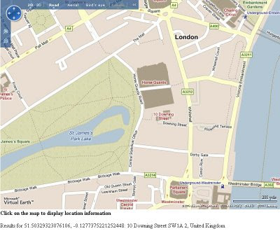
Clicking on the map near roads sends a request to get the address by location (street number, street name,postcode/zipcode & country). In the screenshot a click was made halfway along 'Downing Street' response was 10 Downing Street, SW1A 2, UK.


Virtual Earth has been updated and there is lots of advances and new features this is just one working example that can be implemented in a few lines of code.

To see this working as it should:

http://mapperz.googlepages.com/Virtual_Earth_62_Reverse_Geocoder.html

It will work for any location in the World that is covered by Roads on the Virtual Earth Platform

For more official information please vist

http://blogs.msdn.com/virtualearth/archive/2008/09/24/announcing-the-virtual-earth-web-service-and-virtual-earth-map-control-6-2.aspx


Labels: , , , , , ,

19 May 2008

Yahoo! Internet Location Platform (New Geocoder)

Yahoo! Internet Location Platform (New Geocoder) New!

"The Yahoo! Internet Location Platform provides a resource for managing all geo-permanent named places on Earth. The purpose in creating the Internet Location Platform is to provide the Yahoo! Geographic Developer Community with the vocabulary and grammar to describe the world's geography in an unequivocal, permanent, and language-neutral manner.

The Internet Location Platform is designed to facilitate spatial interoperability and geographic discovery; users can traverse the spatial hierarchy, identify the geography relevant to their users and their business, and in turn, unambiguously geotag, geotarget, and geolocate data across the Web."

Basically this is a Geocoder for Places across the World. The accuracy is fairly precise and the easy to understand.

Here is an example:
http://where.yahooapis.com/v1/places.q('10%20downing%20street%20london%20uk')

and also you can geocode UK Postcodes - full UK Postcodes!

http://where.yahooapis.com/v1/places.q('SW1A2AA')
*link fixed
Yahoo Where Geocoder
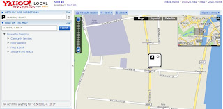
Centroid is the postcode centre. So 51.503201, -0.12617

Checking... on the map.

Yahoo Where Geocoder Map

http://developer.yahoo.com/geo/

Rate Limits
Currently, users of the Internet Location Platform are limited to 50k queries per day.

Terms of Use (Please check this if you intend using this service with other non Yahoo Applications)
http://info.yahoo.com/legal/us/yahoo/api/api-2140.html

Geeky Stuff

"In simple terms, the Service allows you to look up the unique identifier - called the Where on Earth ID, or WOEID - for almost any named place on the Earth; it also allows you to resolve a WOEID you have received from a third party - such as Fire Eagle™ or Upcoming - to the place it represents.

The API is accessed via HTTP GET; the following examples can be cut-and-paste into a web browser to view the results:"
http://developer.yahoo.com/geo/

Mapperz

Labels: , , , , , ,

09 January 2008

Sam Knows Broadband - New Mapping Engine

Sam Knows Broadband - New Mapping Engine

Sam Knows is one of the best independent sites for finding broadband (Phone or Cable) in the United Kingdom. Now their Mapping Application is even easier use.


The 'Old' Mapping required both Telephone (BT) Number and Postcode to find out broadband availability. Now you do not need these.

Sam Knows Broadband UK - Mapping
Reverse Geocoding aids the location search for broadband services in any area of the UK.
Purple Transparent Polygon shows the approximate area of broadband coverage for a BT Exchange.
Try it out here:
http://www.samknows.com/broadband/mapping/mapping.php

The mapping system is designed to be as easy to use as possible. If you just want to browse around your area to see what telephone exchanges are nearby and what services they provide, then simply enter the name of your area in the search box and click Search. You can then zoom in, zoom out or move around the map (by clicking and dragging with your mouse).

Exchanges will appear as blue buildings on the map and will appear dynamically as you move around. You can click on any exchange to see a summary of the wholesale services at the exchange (e.g. the ADSL, SDSL, LLU and cable services in the area).

The Map 'Side Panel' records and shows you more information on the exchange and shows a list of broadband providers with a good approximate maximum speed of broadband
for that location

If you're looking to move home or are just interested in your own area, then the mapping system has something for you too. Click on any road or place on the map to receive useful information including the connected telephone exchange and the distance from it in metres. There's also an option here to perform a broadband availability check.

The new mapping engine makes extensive use of the existing database we have and couples it closely with the Google Maps API, which provides the postcode and address lookup functionality. A special thank you goes to Nico for his Reverse Geocoder addon for the Google Maps API (Click here for more).
Mapperz update - Nico has version
1.0.5 out now:
http://nicogoeminne.googlepages.com/full5.html
"
I added a helper function to search the resulting placemark for a certain property."

The availability checks offer a significant improvement over the existing postcode-level checks in use by sam knows and others. These new checks are premise-level for all ADSL based services and Virgin Media's cable services. The estimated speed for ADSL broadband services is derived directly from BT Wholesale's checker systems. Note that the ADSL2+ speed estimates are derived from the distance from the exchange and the ADSL speed attainable, correlated against the Internode graph

The exchange coverage polygons are derived from known postcodes served by the exchanges (captured from historical checks performed on the existing availability checker). Sampling well over a million such records and combining it the data with Google's geocoding engine has enabled us to produce the polygons. Note that these are likely to be erroneous in some instances, primarily due to a postcode being incorrectly tagged to an exchange. Such errors will be cleared up over time.

Samknows.com is dedicated to tracking the roll-out and progress of broadband across the UK. It was created by Sam Crawford, and is also maintained by Paul Buck and Ian Saunders.

"The site was started as a small hobbyist site after I worked at Datasouth UK on the Hampshire Broadband project. I left there in September 2003 to study for a BSc Hons in Computer Science at the University of Bath. Four years on and I have now graduated with a first-class degree, and will be returning to Canary Wharf this autumn to work as a developer of mobile computing applications."


Well done Sam and the Team.
Nico Reverse Geocoder was blog about here first.
http://mapperz.blogspot.com/2007/08/exclusive-reverse-geocoding-using.html
http://mapperz.blogspot.com/2007/11/google-reverse-geocoder-update.html
Nice to see that it is getting used in full.


Labels: , , , , , , ,

20 November 2007

Google Reverse Geocoder Update

Google Reverse Geocoder Update New! v1.0.2

Reverse Geocoding is the inverse relationship where each geographical coordinate is mapped to the nearest known address. Currently this feature is not directly supported by the Google Map API. But can be done by Nico's Reverse Geocoder for Google Maps API using Google's Directions functionality.

Based on the Original Post by Mapperz


Nico has been keen to add some more useful functionality to the Reverse Geocoder.

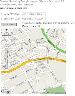
Reverse Geocoding Updated - New v1.0.2

Pan and Zoom click your location and the address and country code is shown.

What is New?
  • all supported countries
  • house number support (experimental)
Test Country support here
http://nicogoeminne.googlepages.com/full2.html

Available Counties:

CountryGClientGeocoderGDirectionsGReverseGeocoder
Austria x x p
Australia x x p
Belgium x x x
Brazil x x x
Canada x x p
The Czech Republic x x p
Denmark x x p
Finland x x p
France x x x
Germany x x x
Hong Kong x n n
Hungary x x p
India x n n
Ireland x x p
Italy x x x
Japan x n n
Luxembourg x x x
The Netherlands x x x
New Zealand x x x
Norway x x p
Poland x x p
Portugal x x p
Singapore x x p
Spain x x p
Sweden x x p
Switzerland x x p
Taiwan x n n
Thailand x x p
United Kingdom x x x
United States x x x

(x=available, n=not available, p=probably available but not tested)

Experimental House Number Support

Since v1.0.2. Once the Reverse geocoder is set up experimental house number support is enabled by calling the setExperimentalHouseNumber method as shown in the example.

reversegeocoder.setExperimentalHouseNumber(true);

Important note:
THIS FEATURE IS EXPERIMENTAL AND USES MULTIPLE
GClientGeocoder AND GDirections
REQUESTS WHICH COULD EXCESS THE GOOGLE REQUEST LIMITS.
That's exactly why it is disabled (uncommented) in the full example.
Use it on own risk.

Labels: , , , , , , , ,

17 August 2007

Exclusive - Reverse Geocoding using Google Maps API only!

Exclusive - ALL New! Reverse Geocoding using Google Maps API only!

Google Maps is great! and the programmers that take the API and do find and create useful applications. Like this Reverse Geocoding

What is reverse geocoding?
"The conversion of latitude and longitude coordinate data of locations into descriptive addresses"

Reverse Geocoding UK Addresses

Try it out here
http://nicogoeminne.googlepages.com/reversegeocode.html

Thanks to Nico Goeminne for finding this algorithm and giving Mapperz the chance to suggest and give exclusive feedback on this incredible function.

Is this legal? - Yes, We have had this confirmed by Pamela Fox (Google Maps API Team) that this is not breaking the Terms of Use - which is great news.

"I checked with a product manager and he looked through our licensing
agreements. The conclusion is that as long as you're not using the
reverse geocoder for real-time tracking of any kind, then you're okay
to use it."

Please use it - suggest comments, feedback always welcome.

Nico's idea came from this
"Google Maps is great! One day I was working on a treasure hunting game, it combined both real world as virtual items placed in and around the very nice city of Ghent (Belgium). At regular times I told them the location (GPS) of an item, so they could go out hunt. Some of them complained because they didn't have a GPS and couldn't find an online tool to convert the GPS coordinates to an address. "No problem I said, I'll fix one up", at that time I did not cross my mind that GM couldn't reverse geocode since before all things I ever needed were just there in that great API. So I was kinda disappointed when I read trough the documentation and even more when I searched the net on the subject. So in the end, I decided to give a try myself and see if I could figure out something and then I stroke me : The GM API has reverse geocoding capabilities. They just call it Driving Directions! Google Maps is great! "

Thanks and all credit to Nico - Excellent Job!

Mapperz Tests a UK version of this method (demo)

Labels: , , , , , , , ,

16 August 2007

New UK Address Geocoder with Sidebar - Google Maps API

UK Geocoder with Sidebar - using Google Maps API


Expanding on the Local Search Geocoder, using the Google AJAX Search API

Please use the Official Example:
http://gmaps-samples.googlecode.com/svn/trunk/geocoder/singlegeocode.html

This New! version use the Google Maps API (based on ESA's orginal code in version 2.55 of the API)

Now that Google Maps API supports UK Geocoding this can be done! (UK Geocoding accuracy has decrease now)

UK Address Geocoder with Clickable Sidebar
Enter a UK Address
Click 'Search'
10 results max are returned
Click on the address to zoom to that location
if you want to click on the marker and select 'copy to memo area'
This stores as many geocoded addresses as you want and then can be copied out to spreadsheet.
This could be then imported to a GIS using the latitude and longitude

Credit to Esa

*Note on the accuracy on the geocoded addresses, it can be up to 150 metres out in any direction.

Labels: , , , , ,

12 July 2007

Batch Geocoder to ArcGIS

Batch Geocoder to ArcGIS Tutorial

(for getting Latitude and Longitude for Postcodes and Addresses)

Now this requires a bit of prior knowledge on Geocoding and Basic GIS Skills

Thanks to Google for providing the UK Geocoding in the Google Maps API

Have a set of addresses or postcodes ready.

*but if you intend to do a huge amount of geocoding it's politer to have your own api key rather than using others

example postcodes used in this example (can be 5 can be 50,000)
AL1 1HH
AL1 1HJ
AL1 1HQ
AL1 1HR
AL1 1PW
AL1 1RZ
AL1 1SD
AL1 1SE
AL1 1SF
AL1 1SG
AL1 1SH
AL1 1SN
AL1 1SQ
AL1 1ST
AL1 1SW
AL1 1XU

or use Addresses like
10 Downing Street, Westminster, London, UK
(can be your own list of clients, businesses, store locations etc)

where do they go?

Either
http://www.batchgeocode.com/
or
http://www.gpsvisualizer.com/geocoder/

(for your own version flow instructions at bottom of gpsvisulizer page)
or
http://www.wotton.org/map/batchgeo.html
(recommended for ease of use)

batch geocoders to gis
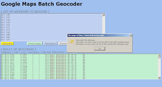
Copy and Paste in the top light blue box, wait until the alert shows the copy and paste from the bottom green box into a New Spreadsheet.

batch geocoders - pasting

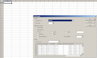
Paste into Open Office Calc or Excel with the correct delimiters.

batch geocoders pasting add decimals

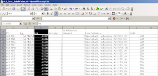
Make the pasted lat and lng's six figures in decimal places
save the spreadsheet


batch geocoding xls arcgis
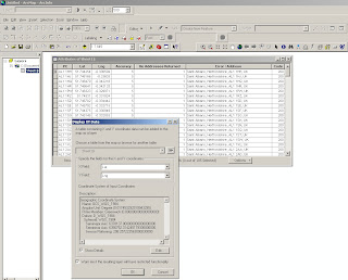
Add the Spreadsheet to ArcGIS (will need a double click if more than 1 worksheet is in the file)

Use WGS84 Geographical Projection to set the Excel Spreadsheet into the correct projection

Use Add XY Data add the data by Lat/Lng and an event theme will be created, this can be exported out as a shapefile or geodatabase.

Important Note: Geocoder Accuracy
ALWAYS check Accuracy - this shows that the all Geocoders have limitations
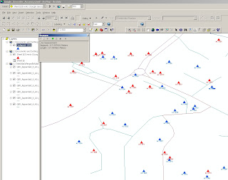
This compares Codepoint (accurate to 100m) to the Google Geocoded Postcodes and there is approximately +/- 150 metres error in their location.

batch geocode check accuracy in GIS

Blue is OS Codepoint in Geographic WGS84
Red is the Google Geocoded Postcodes
(used for a comparison only!)


The method is useful for small datasets, depending on your use.
It could be easily changed to load the geocoded data into a MySQL or Postgres databases for spatial retrieval and added back on to web mapping applications.

Yahoo does Geocode UK Addresses (in some cases more accurate) but it's limitation is that it can only be used on it's on Mapping API and the Geocoder is limited to just 5,000 requests per 24 hours.

For Manual Geocoding
Please use the Official Example:
http://gmaps-samples.googlecode.com/svn/trunk/geocoder/singlegeocode.html

Labels: , , , ,

04 July 2007

Intelligent Free UK Geocoder - All in One.

Update: Just added [Map-Satellite-Hybrid] Controls
Please use the Official Method
http://gmaps-samples.googlecode.com/svn/trunk/geocoder/singlegeocode.html


Twickenham RFC in Satellite Mode

So you can now see Sports Stadiums

Mapperz looked into revamping the UK Geocoder.

and now rolled it into one.

You can now search UK Addresses, UK Postcodes, Global Airports and Global Place names and find the Latitude and Longitude for all of them - to those who don't know what this is called, it is called Geocoding.

Here are a few Examples to get you searching

London Heathrow Airport, you can use the code 'LHR'
Under the Map is the Latitude and Longitude displayed 'up to' full 12 decimal places (but you only need 6 decimal places for the likes of using Google Maps)

UK Geocoder Airports - LHR


Now for a famous Address
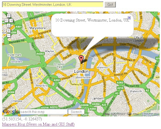
10 Downing Street, Westminster, London, UK

UK Geocoder Addresses - 10 Downing Street

Now how about a large sporting venue?
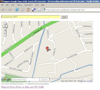
Twickerham Rugby Football Club. You got it

UK Geocoder Points Of Interest - Twickerham RFC

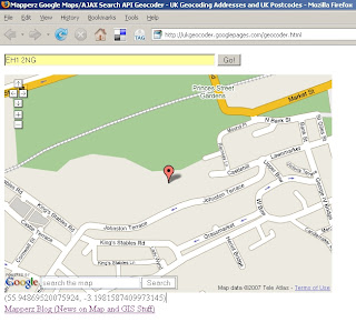
And Famous Postcodes
EH1 2NG
(Edinburgh Castle)

UK Geocoder Postcode - EH1 2NG
Please note if you move/pan on the map the lat and lng is automatically updated.
This is simple and smart. Hence why Mapperz likes it.

How is this done?
This is using Google Map API and Google AJAX Search API - Local Search which was improved for UK last week.
Mapperz just displays the returns the Latitude and Longitude at centre of the map after the information is parsed and centred using Local Search.


to remove the icons - just reload the page 'Ctrl F5'.

The Code is available via View>Page Source 'Ctrl+U'

If you want to have your own version you will need change the
Google Maps API Key
Google AJAX API Key
And find a Webserver (Mapperz using Google Pages in this case)

Labels: , , , , , , ,

22 June 2007

ViaMichelin API Geocodes UK Addresses

ViaMichelin API Geocodes UK Addresses

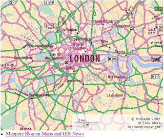
Michelin Maps API - London Map

Works like other Mapping API's out there but is more specific to the European user


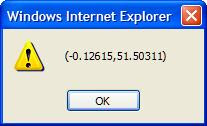
    Geocoder UK Manual showing AlertUK Address Geocoded Alert


      This Geocoder Requests a UK address and returns the lat and lng in an 'alert'
            Yes a bit manual at present, but if your a dab good at Javascript - you can add the map element request an address and have it return on the map.

            ViaMichelin API Map Features:


            • Michelin's high quality maps on-line
            • Driving Directions with 7 types of itinerary : ‘recommended by Michelin’, ‘shortest’, ‘quickest’, ‘economical’, ‘scenic’, ‘on foot’, ‘by bike’.

            • Assure a seamless integration with your site’s look and feel by customizing the colour, opacity and stroke width of the itinerary path displayed on the ViaMichelin map.

            • A proximity and booking search engine, unique in Europe, integrates over 40,000 hotels

            • Checking address and geocoding for exceptional accuracy

            • Implemented entirely in JavaScript, a simple, standard technology!

            If you like this you can sign up (free) to use this service

            Thanks to http://www.renalid.com/ (in French)

            More information on the ViaMichelin Blog

            (ViaMichelin is a subsidiary of Michelin)

            Mapperz

            Labels: , , , , ,

            01 February 2007

            UK Geocoder Maps - Postcode and Street Addresses

            Mapperz has requests after requests on UK Geocoding Postcodes and Addresses for the UK.

            Using Google Maps API and Local Search Two Geocoders have been created

            Please use the Official Method.
            http://gmaps-samples.googlecode.com/svn/trunk/geocoder/singlegeocode.html

            Local Search Example
            http://geo.localsearchmaps.com
            http://geo.localsearchmaps.com/?street=48+Leicester+Square&
            city=London&country=UK
            returns
            map.centerAndZoom(new GPoint(-0.130427, 51.510036), 4);

            Mapperz just returns the GPoint on a Google Map and displays the center of the map

            Top Tip: is you can zoom in after the result is returned to display your Postcode or Address locations.

            Note: This is only using data freely available on the Internet.

            Other Geocoders are available

            US Geocoder

            Yahoo

            InfoSports
            Manual Geocoder

            Batch Geocoder

            Related:
            ASK City Supports Reverse Geocoding

            Simple Geocoding using Google Maps

            3D Geocoding (Microsoft Live Local)


            Geocoding Via Google AJAX Searches

            Labels: , , , , ,

            17 January 2007

            Phoogle Maps (v2.01)

            Phoogle Maps (v2.01) includes International Address Support.
            • 1 Address (Outside United States)
            • Multiple Addresses
            • Displaying Valid/Invalid Points
            • Customizing the Info Window
            Phoogle Maps PHP with Google Maps and Yahoo Geocoder
            "Phoogle Maps (pronounced like Foogle Maps) is a PHP class that integrates itself with the Google Maps API and with the Yahoo Geocoding API to make an easy to use interface to display Google Maps on your site."


            Mapperz Note to Users: Check the Yahoo Maps API Terms and Conditions before investing time on this. There maybe infringement using the Yahoo Geocoder with Google Maps.

            Labels: , , , ,

            15 December 2006

            Online Archaeology Google Map Geocodes UK Addresses

            Online Archaeology
            have integrated a UK Geocoder into the map search this means you can use it to find archaeology near your street.

            Online Archaeology -Integrates UK_Address Geocoding

            This clean and very fast website - seamlessly uses Google Maps API, Google AJAX API and Local Search Address Geocoder.

            Online Archaeology - 10 Downing Street Geocoded

            By far the best website in the UK for Address Location searches on one page.

            Excellent work SteveW (Webmaster) Mapperz glad to help out.


            Labels: , , , , ,

            05 December 2006

            UK Geocoder Goes into Beta

            UK Address Geocoder Goes into Beta
            Been tinkering with this on and off with a good programmer, but made the geocoder more efficient and have checked data is not using and copyrighted data sources.

            Uses the Geocoder Map
            http://gmaps-samples.googlecode.com/svn/trunk/geocoder/singlegeocode.html

            worked from the UK example given
            http://geo.localsearchmaps.com/?street=48+Leicester+Square&city=London &country=UK
            and using that output
            map.centerAndZoom(new GPoint(-0.130427, 51.510036), 4);
            to centre on a google map.

            try it soon.

            pending features - icon displaying in the middle with info window display the input address.
            get better results up to 95/96% match or nearest point to input address.

            quadruple check data source is not crown copyright (have cross-referenced results with address point and they do NOT match).

            Labels: , , , , ,