->

29 January 2010

Mobile GeoRSS Maps *Beta* (Map Channels)

Mobile GeoRSS Maps *Beta* (by Map Channels)

"The easy way to add mapping for mobile websites"

Mobile GeoRSS Maps combines the Google Maps v3 API and Google Feeds API to display a GeoRSS feed on a map that is optimized for mobile phone display.
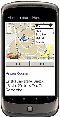
Mobile GeoRSS Maps
Create your own Map with feeds for your mobile, mymaps or georss feeds can auto-update and provide you with latest information whilst on the move.

Use Mobile GeoRSS Maps to simply add your map to your mobile website, or to generate a map link for emailing.

Google My Maps are supported. Use Mobile GeoRSS Maps to generate a mobile version of a My Map in seconds.

Mobile GeoRSS maps works on any phone which supports the Maps v3 API, such as the iPhone and Android or Symbian platforms.
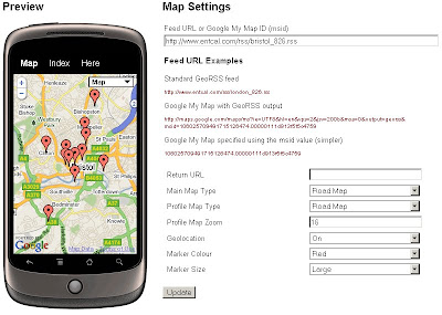
Mobile GeoRSS Maps Preview
Simple instructions to set you up for adding your own feeds to your mobile.

Technical Notes:

This map is a *beta* project, please contact us if you notice any bugs.

Only placemarks in a feed are displayed (lines and polygons are not displayed)

A maximum of 200 placemarks are displayed on the map

Custom Marker styles contained in a My Map are not displayed

base url for the following parameters
http://data.mapchannels.com/mobmap/100/map.htm

f = Feed URL or My Maps ID
r = Return URL
mt = Main Map Type (1=Road Map, 2=Satellite, 3=Hybrid, 4=Terrain)
pt =Profile Map Type (1=Road Map, 2=Satellite, 3=Hybrid, 4=Terrain)
z =Profile Map Zoom (between 1 and 20)
g =Geolocation (0=Off 1=On)
c =Marker Colour (0=Red 1=Blue 2=Green 3=White)

example:
http://data.mapchannels.com/mobmap/100/map.htm?g=1&mt=1&pt=1&z=16&c=0&s=1&f=http://www.entcal.com/rss/bristol_826.rss&r=
(will appear a full page map on a web browser)

Try it out here
http://www.mapchannels.com/MobileGeoRSSMaps.aspx

Nice, clean simple you set up and use, good work by the Map Channels keep up with developments at http://www.mapchannels.com/News.aspx

Labels: , , , , , , , ,

27 January 2010

Klencke Atlas (BIG Maps in a BIG Book)

Klencke Atlas (BIG Maps in a BIG Book)
Klencke-Atlas
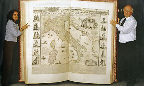
350 Years old, the Klencke is still the largest Atlas in the world on display in London soon at the British Library. dimenions 1.75 metres (5ft) tall and 1.9 metres (6ft) wide

"It takes six people to lift it and has been recorded as the largest book in the world, yet the splendid Klencke Atlas, presented to Charles II on his restoration and now 350 years old, has never been publicly displayed with its pages open. That glaring omission is to be rectified, it was announced by the British Library today, when it will be displayed as one of the stars of its big summer exhibition about maps.

The summer show will feature about 100 maps, considered some of the greatest in the world, with three-quarters of them going on display for the first time."

source:

http://www.guardian.co.uk/books/2010/jan/26/klencke-atlas-british-library-exhibition

The Museum is free to all visitors and is open daily
10.0017.30
Magnificent maps: Power, Propaganda and Art is at the British Library from 30 April to 19 September.

More pictures available at:
http://www.culture24.org.uk/history+%2526+heritage/literature+%2526+music/art75398

Map:
http://www.bl.uk/aboutus/quickinfo/loc/stp/index.html

Links
http://www.jstor.org/pss/4422721 (Re-Binding the Atlas work)
http://www.bl.uk/aboutus/quickinfo/loc/stp/index.html
"Magnificent Maps: Power, Propaganda and Art"
http://www.bl.uk/news/2010/pressrelease20100126.html

Labels: , , , ,

24 January 2010

Google Geocoder Suggests (Esa's Experiments)

Google Geocoder Suggests (Esa's Experiments)

Google has had the 'suggest' option on the main site for a while, yet when you go to the maps you need to know your destination, now you can get help with a geocoder extended with a suggest.

Ahead of the game with Google Map API is Esa with his impressive well thought out experiments.

Google Esa Geocoder Suggests
The example above typing in Bri... suggests 10 locations in Google's Geocoder that are located.
Very clean,very fast and extremely useful.
http://koti.mbnet.fi/ojalesa/boundsbox/geocode_basic_3.htm

Without a Search button - http://koti.mbnet.fi/ojalesa/boundsbox/geocode_basic.htm

*Geocoders are not perfect, they should never be trusted, they are as only good as the accuracy of the original data they were derived from.

Custom Map Types:
Custom Map Types with Geocoder
Custom map Types - here Google Maps with Traffic is synchronised with OpenStreetMap
  • Image map type, like OpenStreetMap tiles in the example page
  • Image overlay map type, like the Traffic tiles in the example page
  • Non-image tile based map type
http://koti.mbnet.fi/ojalesa/v3/osm_dual.htm

Image Map Type behaves just like the standard map types. Image Overlay tiles are displayed on top of the Image Map Types.
The non-image map type makes it possible to create tile layers with SVG, canvas or any html elements
.

Geocoder with Bounding Box - Extent
The v3 Geocoder has extent (Bounding Box) optional, Esa makes this visual with his Bounding Box Page, can be useful narrowing search requests within a specific area.

http://esa.easypagez.com/v3boundsbox/

Sources:
http://koti.mbnet.fi/ojalesa/exam/index.html
(many other examples too)

http://nuppineulat.blogspot.com/ (
Finnish)
http://apitricks.blogspot.com/ (English)

Many thanks to Esa for creating the examples and making them available to budding developers.


Labels: , , , , , ,

21 January 2010

Big News - Nokia Ovi Maps Free for Life

Big News - Nokia Ovi Maps Free for Life

updated 5.07pm 21/01/2010
Nokia Ovi Maps Free for Life
No more subscriptions, Ovi Maps with Navigation (Walking, Driving) is now Free.
*N97 soon after firmware update release.
update N97 users: "New Ovi Maps for N97 will be available on 28th January 2010." with Maps v3.3 included in the firmware update.

note:some N97 users are confirming that the new ovi maps application will install when there is more than 20mb free space on the c: drive (untested by mapperz).

A New version of Ovi Maps 3.3 comes with FREE driving (car) & walking (pedestrian) features turn-by-turn, with voice guided navigation. Ovi Maps has a large global coverage.
74 countries are covered.
Maps Data for all the regions will be available, for free, for loading over the air (data costs!) or pre-loading via a desktop computer (PC or Mac). Traffic information and city guides from the likes of Lonely Planet and Michelin, will also be made available at no additional cost.

Since Nokia owns Navteq (the map data company) they can do this without losing out. So Google, tomtom and many others look out.

Press Release:January 21, 2010
Nokia makes walk and drive navigation free on its smartphones, doubling size of mobile navigation market
http://www.nokia.com/press/press-releases/showpressrelease?newsid=1375569

Video


Official Nokia Maps Website
http://maps.nokia.com/explore-services/ovi-maps/ovi-maps-main

Supported Devices for the Nokia Ovi Maps v3.3
http://europe.nokia.com/support/product-support/maps-support/compatibility-and-download#/default/

More Details at:
http://www.womworld.com/nokia/13158/your-thoughts-on-this-mornings-ovi-maps-announcement/
http://www.allaboutsymbian.com/news/item/11010_Nokias_Ovi_Maps_navigation_goe.php

News Links
PC World
http://www.pcworld.com/article/187335/nokia_delivers_free_navigation_service_to_customers.html

Engadget
http://www.engadget.com/2010/01/21/nokia-ovi-maps-with-free-turn-by-turn-navigation-hands-on/

BBC News
http://news.bbc.co.uk/1/hi/technology/8472165.stm

The Guardian
http://www.guardian.co.uk/technology/2010/jan/21/nokia-satnav-software

The Times Online
http://technology.timesonline.co.uk/tol/news/tech_and_web/article6996954.ece

Labels: , , , , , , ,

20 January 2010

Bing Maps Destination Maps (Map App)

Bing Destination Maps (Map App)

Bing Destination Maps Apps save styles
Bing Maps Destination Maps (Map App) European Map Style.

Bing Map Explorer moved out of beta today, and some new experimental 'Map Apps' have appeared in a continuing effort to make Bing Maps more widley used.

Bing Destination Maps Apps
The Maps are customised by dragging the edges of the rectangle.

Maps Apps are extension tools to Bing Maps they are only accessible in the sliverlight version.
A good link to observe this tools is
http://www.bing.com/community/blogs/maps/archive/2009/12/21/bing-maps-application-gallery-overview-new-apps.aspx

Desination Maps, now this is very new, though basic Map Types 'American' 'European', Sketchy (Pencil) and Treasure Maps Styles.


This App does have great potential if:
Legend can be added
Annotation/Text can be (Title, Comments)
Simple Arrows, Line,point polygons can be added.
Simple layer contol - move minor roads above major roads.

Destination Map Format Export JPEG
Basic Map - though the Destination Map App has good potential if it has a few more customising tools.

Sharing can be improved by allowing users to specify the size and currently only jpeg and pdf formats are available for export.

Will the Bing/Microsoft Research team work on this?

Current coverage:
  • USA
  • Canada
  • Mexico
Source:
http://www.bing.com/community/blogs/maps/archive/2010/01/19/new-bing-maps-application-destination-maps.aspx

Labels: , , , , , , ,

18 January 2010

OSM Routing for Port-au-Prince in Haiti

OSM Routing for Port-au-Prince in Haiti

update: 7pm 18/01/2010

Earthquake Geospatial Research Portal

Free GIS datasets and online resources related to the Haiti Earthquake can be found here.
http://cegrp.cga.harvard.edu/content/haiti-earthquake-data

Open Street Map doing outstanding work (and too many people to thank)

Fully Routing with barriers and obstacles where known.


Port au Prince Haiti Routing Map

Routing & Mapping can help rescuers and target areas with distribution aid.
http://openls.geog.uni-heidelberg.de/osm-haiti/#
*includes high resolution imagery from Geoeye (many thanks)

You can help:

Labels: , , , , , , , , ,

15 January 2010

New Bing Streetside Coverage: Vancouver and Whistler

New Bing Streetside Coverage: Vancouver and Whistler for the Winter Olympics 2010

Streetside Bing Maps Vancouver
Blue represents the Bing Streetside coverage for Vancouver show here.

Streetside Bing Maps Vancouver
Downtown Vancouver, lots of big features gearing up the Winter Olympics 2010 will be held on 12th–28th February.

Streetside Bing Maps Whistler
Whistler is also in the streetside coverage. Lot of building and construction works in preparation of the big events next month.

Google also have Streetview Coverage of Vancouver & Whistler

View Bing New Streetside in Vancouver
http://www.bing.com/maps/explore/#5872/lat=49.282699&lon=-123.119823&alt=13.53&z=30&h=44.9&p=11.7&pid=5082/5003/0.5071=WNB&1.6002=q:Vancouver:lat:51.5120151209378:long:0&o=&a=0:1&n=0

Related links
http://www.vancouver2010.com/

http://en.wikipedia.org/wiki/2010_Winter_Olympics

Previous Post
http://mapperz.blogspot.com/2009/12/big-street-view-update-for-canada.html

Source:
http://www.bing.com/toolbox/blogs/maps/archive/2010/01/15/new-streetside-coverage-vancouver-and-whistler.aspx

Labels: , , , , ,

14 January 2010

Edmonton Opens Up City Data

Edmonton Opens Up City Data

The City of Edmonton in Alberta, Canada is following suit of Vancouver and Toronto and opening up city (public) data.

Data available now (more available after review of the community preview Feb 2010).
  • 2009 Census - Age and Gender
  • 2009 Census - Dwelling Unit Ownership
  • Bus Stops Edmonton Transit Locations
  • City Council Meeting Schedule
  • City Parks Locations of various City parks in Edmonton
  • Community League Centres Locations in Edmonton
  • Locations of all Fire stations in Edmonton
  • Locations of historical buildings in Edmonton
  • List of Planned Road Closures throughout the City of Edmonton
  • Police Stations Locations in Edmonton
  • Locations of School buildings in Edmonton

Though Edmonton take it a stage further and provide feeds and data overlay map ready so users can quickly make use of the data.

Edmonton Bing map
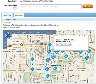
Default View of Bus Stops Overlay on the Edmonton City of Edmonton Website

Getting to the Data
Edmonton KML
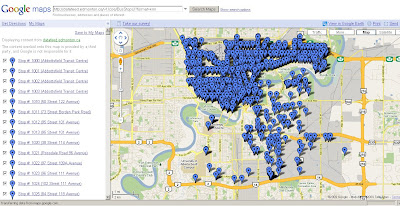
This example show the direct feed http://datafeed.edmonton.ca/v1/coe/BusStops/ as a KML (Google Earth) file loaded directly on Google Maps.
To view this Data as above - http://maps.google.com/?q=http://datafeed.edmonton.ca/v1/coe/BusStops/?format=kml

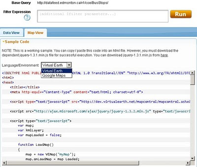
There is a stage futher, not only do City of Edmonton provide Scripts ready made so it makes it much easier for non programmers to create their own web maps.
Edmonton bing map source
Default is Bing (Virtual Earth) Maps though drop-down Language Environment reveals Google Maps API source code.
Mapperz edited mashup
This a mapperz example taken from the code above. Though there are two important changes for the examples to work.
1. jquery-1.3.1.min.js needs to be fully mapped to your server/website
2.Google Maps API requires a specific API Key for YOUR site (API Key signup)

Other changes mapperz made are simply moving the latitude and longitude to centre on Edmonton and not Washington DC.

Links - and Well done to the City of Edmonton making this available.
http://data.edmonton.ca/

mapperz version (tweaked to work)
http://mapperz.googlepages.com/edmonton_google_map_source.html

source:
http://www.calgaryherald.com/Edmonton+releases+downloadable+databases/2438135/story.html

Labels: , , , , , , ,

13 January 2010

New Yell Maps Beta 2010 Online

New Yell Maps Beta 2010 Online
New Yell Maps Beta
New cleaner, faster yell maps, helps users locate local directory listings faster. optional is to display Points of Interest (POI) surrounding the local area.

Yell, the search directory business, is introducing a 'bespoke local business' mapping solution on its Yell.com service.

Yell.com Maps has been developed in partnership with Paris-based specialist provider Tridoo (http://www.onyourmap.fr/), which already provides mapping for Yell’s mobile phone services.

“It needs to be as natural for people to find a local business through Yell Maps as it is with the Yellow Pages directory.” Matthew Bottomley, Director of New Media Product Marketing

Yell.com Maps, which is in beta, is part of Yell’s ongoing development of new technologies to ensure it is the best provider of quality business leads for local businesses. Key features and benefits over the previous mapping service include:

  • Ability to search within the map for local businesses and services
  • Faster response and better geo-coding for increased accuracy
  • Consistent experience across web and mobile
  • Quarterly updates to keep information as accurate as possible
  • Brand new design with bespoke colour-scheme and bigger, clearer maps

Djamila Fernana-Ritchie leads Yell’s mapping team. She said: “This is the first of a number of planned releases designed to make Yell Maps the premier mapping solution for local business search in the UK. "

see the youtube video
http://www.youtube.com/user/yell


The partnership with Paris-based Tridoo has been a cultural and technical shift for Yell. Djamila said:
“It is a relatively small specialist company which has spent the last 10 years at the forefront of mapping and geo-spatial development.

Goal:
“Yell.com Maps is the culmination of all that knowledge, in one platform.”

Yell maps beta is also available via mobile device.

More & Source:
http://www.yellgroup.com/english/media-pressreleases-2009-yellcommakesitsownlocalbusinessmappingservice


Labels: , , , , , ,

11 January 2010

Switch Maps (Google,Yahoo,OSM, Bing...) in One Map

Switch Maps (Google,Yahoo,OSM, Bing...) in One Map

Map Channels have released Switch Maps

Switch Maps by Map Channels
Switch Maps - Straight forward, easy to use and embed in your website or blog.
(Just copy and paste the code)

Switch Maps allow you to create a map that contains:
  • Google Maps
  • Google Earth (3D Globe) - plugin required
  • Street View
  • Bing Maps
  • Bing Maps - Bird's Eye View
  • Open Street Map
  • Yahoo Maps.
Creating a map is very easy select your map type then customise the map controls and set the width & height of your map.
Then use the 'Update' Button then Switch Maps creates the code that will allow you to embed your map in a website or blog.


Try Switching Map modes: Useful if one map type doesn't coverage your area another will.

Switch Maps also includes the option to include layers that show user photos from Panoramio and Picasa.
You can see some of the many map views available in Switch Maps in the Switch Maps Gallery.

Related links:
http://googlemapsmania.blogspot.com/2010/01/google-maps-plus-some.html
http://www.mapchannels.com/SwitchMaps.aspx
http://www.mapchannels.com/News.aspx

Well done to Map Channels on creating this excellent and versatile map creation tool.

Labels: , , , , ,

10 January 2010

Photospots.co.uk Maps (OS & Google)

Photospots.co.uk Maps (OS & Google)

"A website for amateur photographers to share their favourite photography locations."

Photospots.co.uk Google Map
Very clean site with direction of the sun and location of the photograph clearly show for each individual shot.

UK photograph locations have the additional maps from Ordnance Survey Openspace

Photospots.co.uk OS Map
Switching from Google Maps to Ordnance Survey is extremely well implemented no page refreshing required making this very user friendly and usable.

Map and Photographs viewable
http://www.photospots.co.uk/

Blog
http://www.photospots.co.uk/blog/
Well done to Andrew Rickmann http://twitter.com/photospots/

Geograph
A similar and much more established photographic by map location project http://www.geograph.org.uk/ is hugely popular. [1,560,388 images]
"The Geograph British Isles project aims to collect geographically representative photographs and information for every square kilometre of Great Britain and Ireland"

Access to these images can be made by the Geography API.
http://www.geograph.org.uk/help/api

Here under educational licence is a slippy map version
http://www.geograph.org.uk/mapper/

See previous mapperz post on Geograph
http://mapperz.blogspot.com/2007/11/new-draggable-geograph-map-beta.html

Labels: , , , , ,

08 January 2010

Ovi Maps Racing - Sneak Peak

What happens when you combine Ovi Maps and Ovi Games? Ovi Maps Racing is what happens – another gaming title announced today by Nokia, coming soon to the Ovi Store.

Ovi Maps Racing


"In a truly unique experience, you use the GPS in your device to find your location or use Ovi Maps to choose any location in the world), then customize a track around your neighborhood, and finally fire up those engines."


useful? or just fun... you decide.

Labels: , , , , , ,

05 January 2010

A Real Snow Map #uksnow

A Real Snow Map #uksnow

updated 17.51 06/01/2010

A Real Snow Map

via @jasonhesse

More Interactive Maps are
UK SNOW MAP
http://www.raintoday.co.uk/

The Met Office Invent site
http://www.metoffice.gov.uk/public/pws/invent/weathermap/

BBC Weather
http://news.bbc.co.uk/weather/forecast/10209


Wunderground
http://www.wunderground.com/global/UK.html

#uksnow Map 2.0
http://uksnow.benmarsh.co.uk/

UK Snow Dynamic Crowd Sourced Maps

The UK has been experiencing a snow storm recently and people have been tweeting about it!. This page has been setup, as part of my research into crowd sourcing, to track the #uksnow hashtag based on the following format [Postcode District Score/10] since #uksnow became a trending topic. You can help out by tagging the current snow conditions in your own Tweets like this:
http://www.casa.ucl.ac.uk/sjg/twitter/

more info - http://stevenjamesgray.com/projects/uksnowmaps/


Labels: , , , , , ,

01 January 2010

Met Office Data - Visualisation with Maps

Met Office Data - Visualisation with Maps

See the power and innovation of Opening up Government Data.
*in less than a month.

In late 2009 the UK Government launched an Open Data initiative, headed by Sir Tim Berners-Lee, along with a call for innovations challenging the developer community to make this data more accessible.

Geo.me Temperature Map
Geo.me Solutions is showcasing a number of concept demonstrations using map-based visualisations. Like the Temperature Map Above.

The Met Office might supply xml/rdf based data in the future.
But to get the raw data into a useable format Chris Wallace and assistance from Dave Challender make it available now.

Met Office Data Temperature Mashup
All the Met Offices data linked via xml to the stations data.

Background of the Data released last month by the Met Office
Land surface climate station records

The data down-loadable from this page are a subset of the full HadCRUT3 record of global temperatures, which is one of the global temperature records that have underpinned IPCC assessment reports and numerous scientific studies.

The data subset consists of a network of individual land stations that has been designated by the World Meteorological Organization for use in climate monitoring. The data show monthly average temperature values for over 1,500 land stations
http://www.metoffice.gov.uk/climatechange/science/monitoring/subsets.html


Now the Visualising of the data....

Met Office Temperature Mashup Chart
Temperature data that is interactive with the user temperature/timeline with a static map of the location.

Climate Data - An XML/XQuery implementation
Introduction

The UK Met Office recently released the temperature records for about 1600 stations world-wide. Each station record is available online as a text file, for example Stornoway.

"It is expected that longer-term, the MET office itself will make the data available in more readily programmable format. In the meantime, this site offers a number of XML-based resources for access to the data."

The station data and temperature record is available in two forms:


Source
http://www.cems.uwe.ac.uk/xmlwiki/Climate/index.html
http://labs.geo.me/climate_trends

So UK Government opening up the data will encourage innovation and business - so get on with open up the data - by April 2010 (please).

Labels: , , , , , ,