->

17 February 2010

360 Vancouver Aerial Images and Covers Olympic Village

360 Vancouver Aerial Images and Covers Olympic Village

Vancouver 360 Vanier Park
Clean, Smooth and High Resolution 360 Aerial Images of Vancouver

Vanier Park
http://www.aerialphotoimage.com/panoramas/GreaterVancouver/VanierPark.html

Vancouver Water Front
http://www.aerialphotoimage.com/panoramas/GreaterVancouver/VancouverWaterFrontParkAerial.html

And inside BC Place
http://www.aerialphotoimage.com/panoramas/GreaterVancouver/OlympicsOpeningCeremony1.html

Stanley Park
http://www.aerialphotoimage.com/panoramas/GreaterVancouver/VancouverWestEndAerial.html

Labels: , , , , , ,

10 February 2010

New York Times - 3D Olympic Venues Map

New York Times - 3D Olympic Venues Map

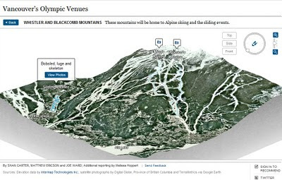
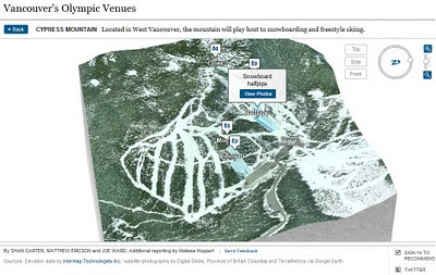
If you want just one map to locate events for the Winter Olympics in Vancouver 2010 then this Interactive and Animated 3D Map created by The New York Times is it.

New York Times Olympic Venues Mapped - 3D Animated
  • Highly Detailed
  • Smooth Animated Zooms to Event Locations
  • Interactive (Users can control 3D aspects panning and zoom)
  • Informative Details on the Sport persons to look out for
  • High Quality Action Photographs.
Clicking from the Map above smoothly zooms to:
New York Times Olympic Venues Mapped - 3D Animated Bobsled
Users can control Aspect using the controls in the top right corner.

New York Times Olympic Venues Mapped - 3D Animated Halfpipe
Using Flash there is a quick response to load up a very impressive 3D Animated Map

Well done to
SHAN CARTER, MATTHEW ERICSON and JOE WARD; Additional reporting by Melissa Hoppert


Sources: Elevation data by Intermap Technologies Inc.; satellite photographs by Digital Globe, Province of British Columbia and TerraMetrics via Google Earth

Visit the New York Times - 3D Olympic Venues Map
http://www.nytimes.com/interactive/2010/02/09/sports/olympics/2010-olympics-venue-map.html


Labels: , , , , , , ,

15 January 2010

New Bing Streetside Coverage: Vancouver and Whistler

New Bing Streetside Coverage: Vancouver and Whistler for the Winter Olympics 2010

Streetside Bing Maps Vancouver
Blue represents the Bing Streetside coverage for Vancouver show here.

Streetside Bing Maps Vancouver
Downtown Vancouver, lots of big features gearing up the Winter Olympics 2010 will be held on 12th–28th February.

Streetside Bing Maps Whistler
Whistler is also in the streetside coverage. Lot of building and construction works in preparation of the big events next month.

Google also have Streetview Coverage of Vancouver & Whistler

View Bing New Streetside in Vancouver
http://www.bing.com/maps/explore/#5872/lat=49.282699&lon=-123.119823&alt=13.53&z=30&h=44.9&p=11.7&pid=5082/5003/0.5071=WNB&1.6002=q:Vancouver:lat:51.5120151209378:long:0&o=&a=0:1&n=0

Related links
http://www.vancouver2010.com/

http://en.wikipedia.org/wiki/2010_Winter_Olympics

Previous Post
http://mapperz.blogspot.com/2009/12/big-street-view-update-for-canada.html

Source:
http://www.bing.com/toolbox/blogs/maps/archive/2010/01/15/new-streetside-coverage-vancouver-and-whistler.aspx

Labels: , , , , ,

29 January 2009

Vancouver 3D

Vancouver 3D

Vancouver 3D
View this online now at http://mapperz.googlepages.com/Vancouver3D.html
(click 'Earth')
**GE plugin required (installs on demand)

Also available in Google Earth.
(there is likely to be a newer version of Google Earth within the next week - a reliable source)

Source:
http://google-latlong.blogspot.com/2009/01/vancouver-in-3d.html

Future Related: - Winter Olympics - Vancouver 2010
http://www.vancouver2010.com/

Labels: , , ,