->

24 December 2010

Pegmans Gets A Hat

Pegmans Gets A Hat
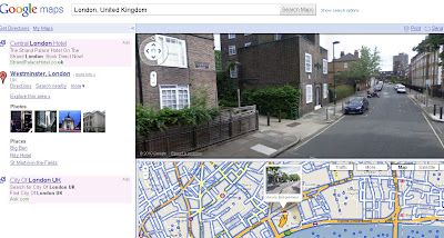
Pegman finds a Hat
Pegman gets a Christmas hat for the weekend? http://goo.gl/maps/jAgL

Predictions - 2011 will bring,

A new perspective to old fashioned raster maps... with the help of HTML5.

OpenStreetMap will go mainstream... more so than at present.

AddressPoint (UK Postal Address locations) become more accessible without huge costs.

Fusion Tables SPATIAL will improve vastly.

Best of 2010 mapping
Opendata from Ordnance Survey. (No April Fools there)

Ovi Maps downloads maps via wifi to phone (no more Ovi Suite!)

Bing Maps Apps more usable adding OpenStreetMap.

MapQuest pump $1million in Open Source Data.

Labels: , , , ,

13 December 2010

Google Zeitgeist Mapped

Google Zeitgeist Mapped

Based on the aggregation of billions of search queries people typed into Google this year.


Labels: , , ,

02 July 2010

Tour de France 2010 Maps

Tour de France 2010 Maps

"A collection of Tour de France Maps for 2010"

The Cycling event starts on 3rd July 2010 and you view some impressive mapping applications. Some will be 'live' during the event.

The 97th annual Tour de France begins on July 3rd in Rotterdam (Prologue Stage), Netherlands and will span 23 riding days en route to the finish on July 25th in Paris, France. Along the 20 Stages coveraging 3,642 km route in totalOfficial Maps The Tour France 2010
Official Tour de France 2010 Maps - surprisingly static but clear and concise
http://www.letour.fr/2010/TDF/COURSE/us/le_parcours.html [Overview Map]
Stages start (with links to other stages)
http://www.letour.fr/2010/TDF/COURSE/us/0/etape_par_etape.html
Also available via the Yahoo Portal
http://uk.eurosport.yahoo.com/cycling/tour-de-france/map.html

Bing Maps App -Tour De France 2010
Tour de France Bing Maps App
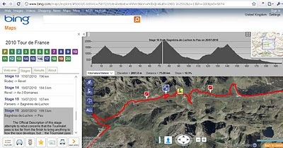
Bing Maps includes elevation gain, slope (-/+%) with an interactive profile chart linked to the map route of each stage.

The 2010 Tour de France map app:

This app is designed to help you visualise the overall race, the stages (stages tab + numbers) and how variables such as weather & elevation (elevation profiles) will impact each stage. Results will be updated along the way in the 'Results' tab.
Check the content in the 'Stages' and 'Results' tabs as you keep track of the greatest cycling race in the world.
http://www.bing.com/maps/explore/#5003/0.60041=/5872/style=be&lat=r4hhm9&lon=h0bqb4&alt=1983.162592&z=13&h=180&pid=5874

Live Tracker of The Tour de France 2010 by Ubilabs
Ubilabs Tour de France Map 2010
This mapping site is consistent every year in providing live racing information on the race.
This year comes with twitter integration and facts and stats (when live racing is on).
http://www.ubilabs.net/tourdefrance/

Cycling News

Cycling News has produce a quick and easy map to all the stages using Google Maps API.
http://www.cyclingnews.com/races/97th-tour-de-france-gt/race-maps

Found more Tour De France Maps - add a comment - look out for updates...

Labels: , , , , , , , ,

23 June 2010

Met Office Events Weather Maps

Met Office Events Weather Maps

Whether your interested in The World Cup in South Africa, Wimbledon Tennis Championships or the Music at the Glastonbury Festival the Met Office has released weather map events.

Met Office Weather Events Glastonbury Map
Check out the Glastonbury Temperature, UV, Pollen Forescast weather is continously updated to provide you with warning (Thunderstorms, high ultraviolet rays and hopefully sun.)

Met Office Weather Events Wimbledon UV Map
See UV Sun Index guidance with the interactive symbols on the Wimbledon Weather Map


"The World Cup finals will, for the first time, be taking place in Africa, with South Africa playing the host nation for what is regarded as the world's largest sporting spectacular.

The tournament is taking place between 11 June 2010 and 11 July 2010.

The Met Office are providing a weather forecast for the venues of the World Cup finals, click on the weather symbols on the map to get more detailed information on the venue of interest. "

Met Office Weather Events World Cup Map
Looks like Sunny all the way in South Africa for the World Cup 2010.

Map Links
http://www.metoffice.gov.uk/public/pws/events/worldcup/
http://www.metoffice.gov.uk/weather/uk/wimbledon.html
http://www.metoffice.gov.uk/weather/uk/glastonbury.html

Source:
http://www.metoffice.gov.uk/public/pws/events/

update: 24th June 2010
Met Office News - Press Release on these Events
http://www.metoffice.gov.uk/corporate/pressoffice/2010/pr20100624.html

Labels: , , , , , , ,

08 June 2010

South Africa Google Streetview Released

South Africa Google Streetview Released

update: now available at http://maps.google.co.za/
South Africa Google Streetview Released
South African Streetview Coverage

Just in time for the Football World Cup 2010.

But don't forget the scenery like this


Official Post:
http://google-latlong.blogspot.com/2010/06/street-view-brings-taste-of-south.html
View Larger Map

Labels: , , , , , ,

31 March 2010

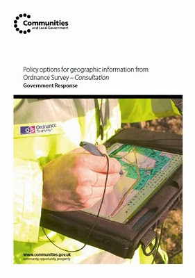
OS OpenData™ Consultation Government Response
OS OpenData™ Consultation Government Response

BREAKING NEWS
Ordnance Survey launches free downloadable maps
Move marks radical departure from previous OS financial model under which every piece of map data had to be paid for

What's Free?

*still needs to be defined.
source:
http://ernestmarples.com/blog/2010/03/government-response-to-ordnance-survey-consultation-published/
Ordnance Survey Government Response
Release of data for free
In response to this support, government will release a range of Ordnance Survey data:
on 1 April 2010, known as OS OpenData™.
The datasets to be released are those set out in the original consultation document as the Free package, with the following changes:

replacement of 1:25 000 and 1:50 000 Scale Colour Raster products with OS VectorMap District

• addition of OS Locator™ and Land-Form PANORAMA to the product list

• replacement of Code-Point by Code-Point Open, which provides accurate locations for 1.7 million postcodes in England, Scotland and Wales.
@mapperz

Straight to the PDF
http://www.communities.gov.uk/documents/corporate/pdf/1528263.pdf

Live links tomorrow!
Happy Mapping... and downloading from

Labels: , , , , , ,

17 February 2010

360 Vancouver Aerial Images and Covers Olympic Village

360 Vancouver Aerial Images and Covers Olympic Village

Vancouver 360 Vanier Park
Clean, Smooth and High Resolution 360 Aerial Images of Vancouver

Vanier Park
http://www.aerialphotoimage.com/panoramas/GreaterVancouver/VanierPark.html

Vancouver Water Front
http://www.aerialphotoimage.com/panoramas/GreaterVancouver/VancouverWaterFrontParkAerial.html

And inside BC Place
http://www.aerialphotoimage.com/panoramas/GreaterVancouver/OlympicsOpeningCeremony1.html

Stanley Park
http://www.aerialphotoimage.com/panoramas/GreaterVancouver/VancouverWestEndAerial.html

Labels: , , , , , ,

10 February 2010

New York Times - 3D Olympic Venues Map

New York Times - 3D Olympic Venues Map
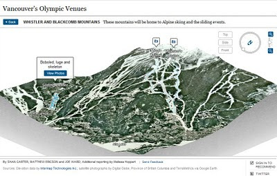
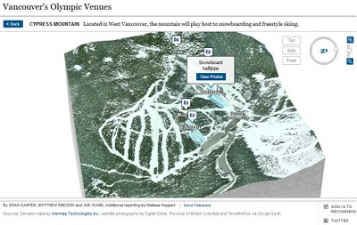
If you want just one map to locate events for the Winter Olympics in Vancouver 2010 then this Interactive and Animated 3D Map created by The New York Times is it.

New York Times Olympic Venues Mapped - 3D Animated
  • Highly Detailed
  • Smooth Animated Zooms to Event Locations
  • Interactive (Users can control 3D aspects panning and zoom)
  • Informative Details on the Sport persons to look out for
  • High Quality Action Photographs.
Clicking from the Map above smoothly zooms to:
New York Times Olympic Venues Mapped - 3D Animated Bobsled
Users can control Aspect using the controls in the top right corner.

New York Times Olympic Venues Mapped - 3D Animated Halfpipe
Using Flash there is a quick response to load up a very impressive 3D Animated Map

Well done to
SHAN CARTER, MATTHEW ERICSON and JOE WARD; Additional reporting by Melissa Hoppert


Sources: Elevation data by Intermap Technologies Inc.; satellite photographs by Digital Globe, Province of British Columbia and TerraMetrics via Google Earth

Visit the New York Times - 3D Olympic Venues Map
http://www.nytimes.com/interactive/2010/02/09/sports/olympics/2010-olympics-venue-map.html


Labels: , , , , , , ,

15 January 2010

New Bing Streetside Coverage: Vancouver and Whistler

New Bing Streetside Coverage: Vancouver and Whistler for the Winter Olympics 2010

Streetside Bing Maps Vancouver
Blue represents the Bing Streetside coverage for Vancouver show here.

Streetside Bing Maps Vancouver
Downtown Vancouver, lots of big features gearing up the Winter Olympics 2010 will be held on 12th–28th February.

Streetside Bing Maps Whistler
Whistler is also in the streetside coverage. Lot of building and construction works in preparation of the big events next month.

Google also have Streetview Coverage of Vancouver & Whistler

View Bing New Streetside in Vancouver
http://www.bing.com/maps/explore/#5872/lat=49.282699&lon=-123.119823&alt=13.53&z=30&h=44.9&p=11.7&pid=5082/5003/0.5071=WNB&1.6002=q:Vancouver:lat:51.5120151209378:long:0&o=&a=0:1&n=0

Related links
http://www.vancouver2010.com/

http://en.wikipedia.org/wiki/2010_Winter_Olympics

Previous Post
http://mapperz.blogspot.com/2009/12/big-street-view-update-for-canada.html

Source:
http://www.bing.com/toolbox/blogs/maps/archive/2010/01/15/new-streetside-coverage-vancouver-and-whistler.aspx

Labels: , , , , ,

13 January 2010

New Yell Maps Beta 2010 Online

New Yell Maps Beta 2010 Online
New Yell Maps Beta
New cleaner, faster yell maps, helps users locate local directory listings faster. optional is to display Points of Interest (POI) surrounding the local area.

Yell, the search directory business, is introducing a 'bespoke local business' mapping solution on its Yell.com service.

Yell.com Maps has been developed in partnership with Paris-based specialist provider Tridoo (http://www.onyourmap.fr/), which already provides mapping for Yell’s mobile phone services.

“It needs to be as natural for people to find a local business through Yell Maps as it is with the Yellow Pages directory.” Matthew Bottomley, Director of New Media Product Marketing

Yell.com Maps, which is in beta, is part of Yell’s ongoing development of new technologies to ensure it is the best provider of quality business leads for local businesses. Key features and benefits over the previous mapping service include:

  • Ability to search within the map for local businesses and services
  • Faster response and better geo-coding for increased accuracy
  • Consistent experience across web and mobile
  • Quarterly updates to keep information as accurate as possible
  • Brand new design with bespoke colour-scheme and bigger, clearer maps

Djamila Fernana-Ritchie leads Yell’s mapping team. She said: “This is the first of a number of planned releases designed to make Yell Maps the premier mapping solution for local business search in the UK. "

see the youtube video
http://www.youtube.com/user/yell


The partnership with Paris-based Tridoo has been a cultural and technical shift for Yell. Djamila said:
“It is a relatively small specialist company which has spent the last 10 years at the forefront of mapping and geo-spatial development.

Goal:
“Yell.com Maps is the culmination of all that knowledge, in one platform.”

Yell maps beta is also available via mobile device.

More & Source:
http://www.yellgroup.com/english/media-pressreleases-2009-yellcommakesitsownlocalbusinessmappingservice


Labels: , , , , , ,

09 October 2009

OpenStreetMap Formula 1 Circuits

OpenStreetMap Formula 1 Circuits

F1 OpenStreetMap Circuits
OpenStreetMap Formula 1 Circuit - Circuit de Monaco (Monaco)

OpenStreetMapper '

Labels: , , , , , , , ,

06 August 2009

BBC Sport: World Cup 2010 Map - South Africa

BBC Sport have launched the 'World Cup 2010 Map - South Africa Map'

Use the map to explore preparations for the 2010 World Cup in video, audio, pictures and text.

BBC Sport World Cup 2010 Map

One first load, the map shows all 10 World Cup venues in South Africa.

Click on a pictures to find out more about the venue in question. Use the map's controls, in the top left-hand corner, to zoom in and discover more venues.

This map will be regularly updated with photos, video and text in the run-up to the World Cup 2010

Source & Map
http://news.bbc.co.uk/sport1/hi/football/8094737.stm

Labels: , , , , ,

29 January 2009

Vancouver 3D

Vancouver 3D

Vancouver 3D
View this online now at http://mapperz.googlepages.com/Vancouver3D.html
(click 'Earth')
**GE plugin required (installs on demand)

Also available in Google Earth.
(there is likely to be a newer version of Google Earth within the next week - a reliable source)

Source:
http://google-latlong.blogspot.com/2009/01/vancouver-in-3d.html

Future Related: - Winter Olympics - Vancouver 2010
http://www.vancouver2010.com/

Labels: , , ,