->

22 July 2011

Met Office - Storm Tracker Beta

Met Office - Storm Tracker Beta

Met Office Storm Tracker

The Met Office has created a new Google Maps Flash Map to monitor and forecast tropical storms around the world.

There are two versions of this map - Free and Premium (Paid For)

Free Version
· 1 x forecast weather layer (UK deterministic 5 day storm track)
· 1 x observed track
· 3 x latest weather layers:
· cloud (IR and Visible satellite)
· sea surface temperatures
· Thousands of historic storms (HURDAT data from 1850 until the present).

Advanced version (paid for service)
Additional premium content for an advanced service is available at a subscription rate.
The advanced service includes access to all the above, plus:
· Probabilistic forecasts of storms and weather – so a range of possible scenarios
can be understood
· Met Office 15 day ensemble forecast storm tracks; and equivalent data from
European Centre for Medium-range Weather Forecasting (ECMWF) and USA’s
National Oceanic and Atmospheric Administration (NOAA).
· Multi-model combinations of these leading models

· Additional forecasts for storms, including strike probabilities, forming storms, and
ensemble mean storm tracks
· A utilities layer showing district boundaries for the Gulf of Mexico
Access to these features enables users to build a far more complete picture

Users require to have an account (even for the free version) worldwide cloud conditions and the locations of current cyclones. If you select a cyclone on the map you can view the cyclone's observed track and wind speeds recorded along the track.

As well as viewing current tropical storm conditions it is also possible to view historical storm information. For example you can view the track of the 2009 Hurricane Bill.


Met Office Storm Tracker Historic Tracks


Storm Tracker Worldwide Map by the UK Met Office.
http://www.metoffice.gov.uk/premium/stormtracker/
(sign up and login required to view both free and premium)

Source:
http://googlemapsmania.blogspot.com/2011/07/worldwide-tropical-storm-tracker.html

Labels: , , , , , ,

03 May 2011

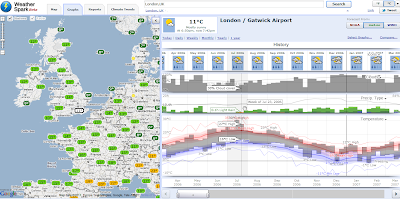
WeatherSpark Beta

WeatherSpark Beta- Historical weather patterns visualised

An excellent Google maps mashup -an early contender for best gmap 2011.

WeatherSpark Beta


"WeatherSpark is a pretty amazing Google Map of current and historical weather conditions. The site lets you view the historical records of over 4,000 weather stations."

example above
http://weatherspark.com/#!graphs;ws=28726;t=321909;mspp=37115493


Climate Patterns
WeatherSpark Climate Beta


If you are more interested in today's weather you can just center the map on your location and view the current temperature and the current precipitation radar

http://weatherspark.com/#

source:
http://googlemapsmania.blogspot.com/2011/05/history-of-weather-on-google-maps.html

Labels: , , ,

01 September 2010

New BBC Travel Maps (Beta)

New BBC Travel Maps (Beta)

New BBC Travel Maps (Beta)
Improved Navigation and live feeds (jamcams included), much better Travel News from the BBC.

http://www.bbc.co.uk/travelbeta/birmingham/

What's new:
  • Updated design, with wider pages and larger text.
  • Improved navigation, allowing movement between adjacent geographic areas
  • Interactive mapping, which can be minimised if you prefer the text incident list
  • Clearer timestamping of incidents.
  • Traffic jam cams showing frequently updated still images of traffic conditions on motorways and trunk roads
Addional Improvements
  • The text incident list has been updated to improve readability, and is synchronised with the map.
  • Local weather forecast from the BBC Weather Centre for the next 6 hours from now
  • Backend improvements to our data-handling system to categorise data, and speed up the reception and delivery of data to the site.

What's not changed:
  • BBC's comprehensive traffic and travel information remains at the core of the service, updated around the clock
  • The text list remains, and you can hide/minimise the map, to put the functionality of the site back to the way it used to be.
  • BBC have made the redesign as subtle as possible, in order to retain the things you've told us you like about the existing site.
  • In the final version of the site, you'll be able to click to see a country-wide motorways or major roads overview from every page.
  • BBC's door-to-door journey planner, powered by Transport Direct, remains but has been made more prominent.

Why a new version of BBC Travel News:

"Firstly, to update the design to take advantage of the BBC's wider page layout, introduce maps across the site for the first time, and make some basic improvements to the presentation of our information
Secondly, to improve the data-handling processes behind the scenes, to allow us to separate the data into more useful groups, and reduce the time it takes for the data to reach you
Thirdly, to integrate traffic jam cameras (where available) into the main BBC Travel News website alongside our incident data"

Current BBC Travel Maps (Beta) Areas:

Birmingham beta
Black Country beta
Coventry beta
Herefordshire beta
Shropshire beta
Staffordshire beta
Warwickshire beta
West Midlands beta
Worcestershire beta
Wolverhampton beta

Labels: , , , ,

05 August 2010

UK SiteSeeker (Beta) Map

UK SiteSeeker (Beta) Map

"Whether you're a seasoned camper, caravanner or motor caravanner, or new to taking your accommodation with you, the Club will help you to get more from your caravanning and camping holidays. "

Find Electric Hook-ups, HardStanding, Full Service within a search radius from 5 miles to 50 miles using this help map.
SiteSeeker Caravan sites Google Map cornwall within 10 mile radius
Find Caravan electrical hook up sites using the Map


Modify your search even further with the 'choose facilities' option at the bottom of the map.

Try the interactive map here:

Labels: , , , ,

27 July 2010

The UK SoundMap Beta - British Library

UK SoundMap starts with a pilot survey based on the Sheffield metropolitan area. The national survey will follow later in 2010. 
The UK SoundMap Beta - British Library


Make sure Location Services in Settings/General is switched on. Otherwise you can edit your recording on Audioboo FM and add a location by placing the microphone icon on the map at the place where you made the recording

How can I take part?

If you can make recordings in any location within the Sheffield area, please record your surroundings, describe them with tags and comments, then upload the recordings to our map. From there, a permanent public record of everyday sounds - the UK SoundMap - will be made accessible to everyone, while being stored at the British Library and made available to soundscape experts.

Want to add your sounds to the map then follow these steps;

  1. register with AudioBoo
  2. record & publish
  3. listen to soundscapes

Ways to record and publish

There are two ways. The easiest way is to use a smartphone. Alternatively you can use a web browser.

Listen to soundscapes

Once uploaded, your recordings will be found easily as locations on the soundmap and searchable by tags. Please allow 48 hours for your recordings to appear on UKSoundMap. You can meanwhile check your recordings right away on AudioBoo.fm

  • Just record your everyday surroundings.
  • What do your home, leisure and work environments sound like?


    • What sounds define these places and how do they make you feel? Some may be restful, some unpleasant - let us know why.
  • Does the sound of these places differ during the day?


    • What are the differences? Let us know what these sounds mean to you.
  • Where are the noisiest or quietest parts of your locality?


    • What makes it so noisy? What can be heard even when it's quiet?
  • Make as many recordings as you like at different locations and times.
  • Each recording may be up to 5 minutes long.
Map
http://sounds.bl.uk/uksoundmap/map.aspx

Source:
http://sounds.bl.uk/uksoundmap/index.aspx

    Labels: , , , ,

    21 July 2010

    MapQuest Open (Beta) Using Open Street Map Data

    MapQuest Open (Beta) Using Open Street Map Data


    MapQuest Open Beta Open Street Map Data and Routes
    MapQuest have over the past few months vastly improved the map user interface and are one of the first major mapping service to engage and encourage the use of Open Street Map Data with the new MapQuest Open mapping project.


    "At the 4th annual international State of the Map 2010 conference, their plan to be the first major mapping site to embrace and encourage open source mapping at scale.  As part of this initiative, MapQuest just launched their first site that is completely powered by open source data from OpenStreetMap.org"


    "This new project – open.mapquest.co.uk – was developed using the new MapQuest.com design but using data provided by the OpenStreetMap community.  The main difference between this new site and our existing MapQuest UK site is that the mapping and routing data was created, edited and enhanced by every day people like you.  OpenStreetMap was designed to give the local community the ability to update areas (roads, parks, hiking trails, bike paths, points of interest, etc) that they know in their own neighborhood and around the world, ultimately leading to what we believe will be the best and most accurate mapping experience for all.


    AOL (owners of Mapquest) also announced a $1 million open-source mapping investment fund.  This fund will support the growth of open-source mapping in the United States in the local communities that Patch.com covers.  More information about the AOL grant application process is available by emailing osm@mapquest.com."


    View the new Mapping Service - http://open.mapquest.co.uk/

    More information - http://blog.mapquest.com/2010/07/09/mapquest-opens-up/
    Well done to Mapquest for taking the challenge on and implementing a clean and easy to use mapping service.


    Source:
    http://www.openstreetmap.org/user/Harry%20Wood/diary/11288

    Please give your feedback here http://mapquest.open-street-map.sgizmo.com/s3/

    Labels: , , , ,

    17 June 2010

    New! Explore Yell.com in 3D Photo-real Maps UK

    New! Explore Yell.com in 3D Photo-real Maps UK

    Yell_Beta_Photo_Real_3D_Cities_UK
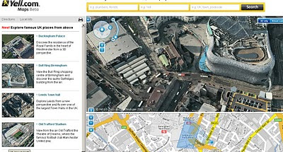
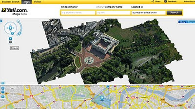
    3D Photo-real imagery comes to a few cities in the United Kingdom in Yell Maps Beta.

    "In a UK-first, the photo-realistic 3D maps were created from actual film footage shot from light aeroplanes using sophisticated aerospace technology, which is then merged with other film taken from ground level. They can be used for free on the Yell.com website, which is the online version of the Yellow Pages directory. "

    Yell Beta Photo Real 3D Cities UK - Buckingham Palace
    Rendering in 3D Buckingham Palace.
    Discover the residence of the Royal Family in the heart of Westminster from a 3D perspective.

    View the Bull Ring shopping centre of Birmingham and discover the quirky Selfridges building from the air.


    Explore Leeds from a new perspective and fly over one of the largest Town Halls in the UK.


    View from the air Old Trafford the Theatre of Dreams, where the famous football club Manchester United play.

    Full Url to the Birmingham Bullring

    Source:
    Slashgeo

    Labels: , , , , , ,

    09 June 2010

    Google Android Navigation Expands

    Google Android Navigation Expands

    Google Maps Navigation version 4.2 is now available in Austria, Belgium, Canada, Denmark, France, Germany, Italy, the Netherlands, Portugal, Spain, and Switzerland
    *
    for Android devices 1.6+

    Google Navigation Coverage Map


    Google first added free turn-by-turn voice guidance to its smartphone operating system in October last year. The move has had some lasting effects on the navigation sector. For example, Nokia followed in Google's footsteps and announced free turn-by-turn voice guidance for Ovi Maps in January.

    Sources:
    http://www.pcworld.com/article/198376/googles_turnbyturn_navigation_comes_to_more_countries.html

    http://googlemapsmania.blogspot.com/2010/06/google-maps-navigation-going-global.html
    Official Post:
    http://googlemobile.blogspot.com/2010/06/fun-on-autobahn-google-maps-navigation.html

    Labels: , , , , ,

    30 March 2010

    OpenAddresses.org (Beta)


    OpenAddresses.org (Beta)

    "An Open Source web portail for the management of Open worldwide geolocated postal addresses."

    openaddresses.org

    New York City (NYC) show address points (geocodes) link

    http://www.openaddresses.org/?northing=4975719.1423499&easting=-8240566.8885371&zoom=15&overlayOpacity=0.62

    www.openaddresses.org offers an easy to use address editing service and geocoding/reverse geocoding services based on address data.

    www.openaddresses.org stores ONLY geolocated postal addresses. Features associated to postal addresses like persons, companies, point of interests are not part of openaddresses.

    www.openaddresses.org aims to collaborate nicely with www.openstreetmap.org by exchanging data, but since localized addresses are a very specific topic, it is appropriate to have a plattform dedicated only to addresses.

    www.openaddresses.org is based on an original idea of Hans-Jörg Stark who initiated www.openaddresses.ch and www.openaddresses.at

    Project home:http://code.google.com/p/openaddresses/


    To do (as Beta)

    source:

    Labels: , , , ,

    10 March 2010

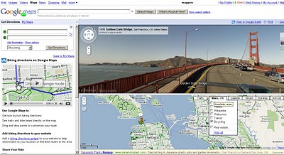
    Biking Directions on Google Maps - New!

    Biking Directions on Google Maps - New! (in beta)
    Biking Cycling Directions on Google Maps in Beta
    Green 'highlighted' lines are specific for Cyclists using Google Bicycle directions

    • Bike lanes: For more than 150 cities in the US, we know which streets have dedicated bicycle lanes. These are also prioritized when coming up with a routing suggestion. On the bicycling layer, you’ll see these roads indicated in bright green.
    • Recommended routes: For many cities we also provide information on streets that have been designated as good for cyclists, so we them into account in our algorithm. These roads are indicated with dashed green lines on our bicycling layer.
    • Uphill slopes: l don't know anyone who enjoys biking up a hill, especially when you're trying to get somewhere you need to be. Going uphill is worse than simply being much slower; it's also exhausting and can take a toll on the rest of your ride. Our biking directions are based on a physical model of the amount of power your body has to exert given the slope of the road you’re biking on. Assuming typical values for mass and for wind resistance, we compute the effort you’ll require and the speed you’ll achieve while going uphill. We take this speed into account when determining the time estimate for your journey, and we also try hard to avoid routes that will require an unreasonable degree of exertion. Sometimes the model will determine that it's far more efficient to make you ride several extra blocks than to have to deal with a massive hill. My teammates in San Francisco were relieved to see that this does indeed work!
    • Downhill slopes: Many cyclists will tell you that going downhill is annoying for a different reason: you may have to ride your brakes all the way down. All else equal, we try to avoid routes that require a lot of braking. Of course, in some cities, including my hometown of Seattle, this isn’t always possible! And if you feel like you need a big workout and want to climb some hills, or if you just love that wind-in-your-hair feeling of a long downhill (you better be wearing a helmet and staying safe!), you can always turn on the terrain layer to check out the hilliness of an area for yourself.
    • Busy roads: Cyclists often tend to prefer to stay off of fast roads, and not even cross them unless it's necessary. This is roughly the inverse of driving directions, where you want to stay on arterials and freeways, so we had to rework a lot of those fundamental calculations when coming up with our biking directions algorithm.
    • Busy intersections: We try to avoid making you cross busy streets with a lot of car traffic and long wait times.


    Try it (US only currently)
    http://maps.google.com/biking
    (goes into official mapplet mode)

    The Official Blog Post is now available:
    http://googleblog.blogspot.com/2010/03/biking-directions-added-to-google-maps.html

    and official cross blog post
    http://google-latlong.blogspot.com/2010/03/its-time-to-bike.html

    updates
    @Mapperz

    Labels: , , , , ,

    03 March 2010

    Protected Planet Map (Beta)

    Protected Planet Map (Beta)
    "The latest initiative of the World Database on Protected Areas."

    Protected Planet Map (Beta
    Simple concept map every protected area on the planet:

    Database:
    Compiling a database containing every protected area on our rather crowded globe is no easy task. It has taken 25 years to reach this stage. There are gaps (UK has none!) and errors and we want you to help us make it right through protectedplanet.net.

    Browse, explore and be amazed at some of the most bio-diverse places on the planet.
    If you give feedback, we [protectedplanet.net] will try our best to consider what you say as we keep developing.

    One thing to keep in mind, not every protected area from the World Database on Protected Areas (WDPA) is in the beta.

    "Explore protected areas. Discover how we are protecting the planet. Be part of the solution. Over the last three months we have been working hard developing a new and inspiring way to discover almost all protected areas on the planet. We were planning on launching the website later in the year however we were enjoying using the website so much, we thought we would share some of that delight and release a beta version for you. We hope you enjoy it. If you do like what we are doing then keep checking the website; every two weeks there will be something new to see!"

    The latest initiative of the World Database on Protected Areas.

    Future:
    IN TWO WEEKS

    You will be able to see how the world is protected with the new thematic mapping feature.

    IN FOUR WEEKS

    The community will be able to make a difference in global conservation

    Widget Maps Examples
    Spain
    http://widgets.gbif.org/pa/#/country/ES

    Yellowstone NP Widget Map
    Yellowstone National Park Gridded Diversity
    Yellowstone National Park (USA)
    http://widgets.gbif.org/pa/#/area/377207

    Australia
    http://widgets.gbif.org/pa/#/country/AU

    Download
    Users can download the data in either txt, kml, csv or xls files..

    More about ProtectedPlanet.net
    http://www.protectedplanet.net/about

    Developed by Vizzuality

    Labels: , , , , , ,

    12 February 2010

    Google Maps Gets Beta Labs

    Google Maps Gets Beta Labs
    *Google Account signin required
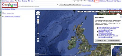
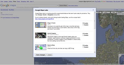
    Google Map has now enabled Google Labs experiments that you can now add some nice and useful functionality.

    Google Maps Labs Rotated
    A new prespective - Note the Map Labels (Text) are correct way up but the map is upsidedown.


    Google Maps Labs New
    New Features and Tools in Google Maps via Google Maps Labs - Rotate Map Types (Sat

    Google Labs experiments that you can now add the following functionality:

    Drag 'n' Zoom
    Zooming in on a specific part of the map is now fast and easy. Simply click the Drag 'n' Zoom button, draw a box on the map.
    Google Maps Labs

    Google Maps Labs Drag Zoom
    New Button for Drag Zoom - Useful!

    Click on the Green beaker New! to access the new features (simliar to gmail labs)

    The Options are as follows
    Aerial Imagery (Includes Rotate)
    Add Aerial imagery to the map! Aerial imagery gives you rotatable, high-resolution overhead imagery presented in a new perspective. Currently imagery is only available in certain areas, but we're adding more all the time.

    Back to Beta
    Gmail isn't the only one that can enjoy a BETA tag.

    Where in the World Game
    Test your knowledge of world geography. Guess the name of the country from satellite imagery, and try to beat your top score.

    Rotatable Maps
    Tired of North always being up? Add rotatable map types and give East, West and South a fair go.

    What's Around Here?
    Adds a second search button that searches for "*", returning the top results in the current view. A great way to browse the map.

    LatLng Tooltip
    Displays a tooltip next to the mouse cursor showing the latlng directly underneath it.

    LatLng Marker
    Adds an option to the context menu that lets you drop a mini marker showing the latlng of the position that the cursor was pointing at when the context menu was evoked.

    Smart Zoom
    Ever zoom in too far and get the message "We don't have imagery at this zoom level"? Ensure you don't see it again, with Smart Zoom, which will check in advance what imagery exists, and ensure you can't zoom in beyond it.

    source:
    http://blogoscoped.com/archive/2010-02-12-n86.html
    Related
    http://googlemapsmania.blogspot.com/2010/02/google-maps-in-google-labs.html
    Official Post
    http://google-latlong.blogspot.com/2010/02/introducing-google-maps-labs-your.html

    Labels: , , , , , ,

    13 January 2010

    New Yell Maps Beta 2010 Online

    New Yell Maps Beta 2010 Online
    New Yell Maps Beta
    New cleaner, faster yell maps, helps users locate local directory listings faster. optional is to display Points of Interest (POI) surrounding the local area.

    Yell, the search directory business, is introducing a 'bespoke local business' mapping solution on its Yell.com service.

    Yell.com Maps has been developed in partnership with Paris-based specialist provider Tridoo (http://www.onyourmap.fr/), which already provides mapping for Yell’s mobile phone services.

    “It needs to be as natural for people to find a local business through Yell Maps as it is with the Yellow Pages directory.” Matthew Bottomley, Director of New Media Product Marketing

    Yell.com Maps, which is in beta, is part of Yell’s ongoing development of new technologies to ensure it is the best provider of quality business leads for local businesses. Key features and benefits over the previous mapping service include:

    • Ability to search within the map for local businesses and services
    • Faster response and better geo-coding for increased accuracy
    • Consistent experience across web and mobile
    • Quarterly updates to keep information as accurate as possible
    • Brand new design with bespoke colour-scheme and bigger, clearer maps

    Djamila Fernana-Ritchie leads Yell’s mapping team. She said: “This is the first of a number of planned releases designed to make Yell Maps the premier mapping solution for local business search in the UK. "

    see the youtube video
    http://www.youtube.com/user/yell


    The partnership with Paris-based Tridoo has been a cultural and technical shift for Yell. Djamila said:
    “It is a relatively small specialist company which has spent the last 10 years at the forefront of mapping and geo-spatial development.

    Goal:
    “Yell.com Maps is the culmination of all that knowledge, in one platform.”

    Yell maps beta is also available via mobile device.

    More & Source:
    http://www.yellgroup.com/english/media-pressreleases-2009-yellcommakesitsownlocalbusinessmappingservice


    Labels: , , , , , ,

    02 November 2009

    Weather.com goes into the 'Future' (Bing Maps)

    Weather.com goes into the 'Future' (Bing Maps)

    Weather.com Temperature Bing Future Map BetaWeather.com Cloud and Radar Bing Future Map Beta
    The new 'Future' button starts moving into a predicted mode using 'trupoint' technology at 15 minute intervals up to 6 hours into the future.

    http://www.weather.com/weather/map/interactive/30004?from=36hr_maps&zoom=8&interactiveMapLayer=radar


    "The Weather Channel's unique TruPointSM technology delivers the most accurate weather reports and forecasts - for more locations - than any other weather provider.

    NEW: TruPoint technology is now available on weather.com interactive maps! See exactly where storms are forecasted for up to the next six hours so you can better plan and prepare for any activity."


    Summary of TruePoint Technology

  • A highly localized weather forecast; accurate down to a one-square mile area.
  • Allows you to zero in on specific places such as schools and parks.
  • Available every 15 minutes across a 6 hour period.
  • Available only within the 48 contiguous United States.
  • A proprietary technology developed and used exclusively by The Weather Channel.
  • Full details on the technology here:
    http://www.weather.com/encyclopedia/trupoint.html?from=hrly_trupointlogo

    source:
    http://www.bing.com/community/blogs/maps/archive/2009/11/01/weather-com-adds-futures-on-bing-maps.aspx

    Labels: , , , , , , ,

    08 September 2009

    Ovi SDK - Map Beta Examples - First Look

    Ovi SDK - Map Beta Examples - First Look

    It is nearly a week since the public release of the Ovi [Nokia] SDK

    Mapping Wise what can you do with it?

    Ovi Map Example Apps
    Well the first version had an issue - apps would not show, but this has been rectified and now the examples will show in the Nokia(N97) Emulator.

    This example shows a few options.
    Drop Pin
    POI Icons
    Server Icon (Wifi/3G connection required)
    Local (Phone memory in the app)
    Polyline (now we are getting somewhere)
    Polygons - Reviewed
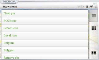
    Map Content Example
    Landscape mode enabled - shows all example with out needing to scroll.

    Polygon Example

    mapperz wasn't happy with the example polygon - it didn't seem that helpful

    Ovi Maps Beta Example Polygon Bristol,UK
    Custom Polygon generated in Ovi Map Player using the Ovi Apps SDK
    (mapperz customised the orginal example with something slightly better)
    So how was this achieved?

    Well you can study the Development Guide or the API Library that comes zipped up
    However the fastest way to learn is working examples

    The code was found in mapfunctions.js
    (in the Downloaded SDK >com.nokia.maps.examples.mapContent)
    in here there is a section of code:

    Example – Adding a Polygon to the Map
    */
    function addPolygon()
    {
    var polygon = {
    type: "polygon",
    points:
    [{latitude: 51.45128846597743, longitude: -2.5956809520721436}, {latitude: 51.45115474591054, longitude: -2.5934386253356934}, {latitude: 51.44976403399727, longitude: -2.5936853885650635}, {latitude: 51.449957933872724, longitude: -2.595916986465454}],
    visible: true,
    width: 5,
    color: {red: 180, blue: 20, green: 0, alpha: 255},
    fillColor: {red: 0, blue: 0, green: 0, alpha: 100}
    };
    // Set zoom level
    player.map.setZoomScale(500);

    // Move map center to a central location between the three points of the polygon:
    player.map.moveTo({
    latitude: 51.45052625634988,
    longitude: -2.5947046279907227
    });

    // Create a layer:
    //var layer = player.map.createLayer({name: "testLayer1"});

    // Add the polygon:
    var mapObjects1 = layer.addMapObjects(polygon);

    }


    all that code for one square polygon? well yes...

    Now in real-world terms you need quite a lot of information before you start:
    Coordinates for each vertices is required to have
    {latitude: 51.45128846597743, longitude: -2.5956809520721436}
    easier would be: {lat1:
    51.451288,lng:-2.595680}
    but it would be simpler to list them in a clockwise order.
    or you end up copying and pasting lots of coordinates for quite simple shapes.

    **note make sure you use {} 'curly brackets' and not () 'normal brackets' or you will get javascript errors.

    There is currently no option for holes in polygons (donut polygons)
    What would really help is the ability to overlay KML/GPX files from servers or accessed from the device.

    Not sure why zoom extent coordinates are required - would be easier for the extent of the polygon(s) to be used.

    Less code makes faster devices (http://www.bewebmaster.com/42.php)
    color: {red: 180, blue: 20, green: 0, alpha: 255},
    fillColor: {red: 0, blue: 0, green: 0, alpha: 100}

    how about:
    rgb:180,20,0,255
    fill:0,0,0,100


    Was hoping to evaulate the New Ovi Maps Navigiation API though in reading the documentation you get a message:

    NOTE: The functionality described here is not yet available.

    Would prefer they left it out until it was available - would presume that this requires an api key of sorts - but if wanted it tested and de-bugged in beta you would think it would be.


    There is demand for this - many, many mobile devices are geo-aware and can use this but it seems clearer there is going to be a good few months of re-writting code to make this a truely customisatable portable mapping and navigational system.
    Mapperz will review when activated.

    The SDK has been written by techinical people and it does show. They say you are required some basic knowledge of html & javascript.
    Mapperz would say you are required to be at an intermediate level for javascript, html,css and de-bugging.
    Note: The Software Aptana 1.5 is required to do serious work in the Ovi Apps SDK.

    Nokia have the resources they just need to apply it a little stronger.
    Web Documentation would be also helpful - like many other mapping apis available.

    So the answer to their blog
    "OviSDK+you=Ovi Apps for Everyone"
    http://blog.ovi.com/2009/09/03/ovi-sdk-you-ovi-apps-for-everyone/?utm_source=rss&utm_medium=rss&utm_campaign=ovi-sdk-you-ovi-apps-for-everyone

    is no currently and unfortunately (hope this changes)

    Action please
    Nokia need people with basic programming - to read their documentation and highlight areas of explanation.

    Ovi Maps Player API stongest competitor is going to be Google Map API (v3) There are some interesting features coming to it in the coming weeks, stay tuned.

    When these teething issues have been ironed out then they will have a competitive product.
    There is no indication whether the Navigation API will require a licence.
    Currently Nokia Ovi Map users require a daily,weekly,monthly or yearly licence to use Navigational Features, if you make an app with it - does everyone require a seperate licence.
    If they do it will be a stumbling block for a promising feature.

    Labels: , , , , , , , ,

    29 June 2009

    National Trust Map (Beta)

    National Trust Map (Beta)

    National Trust Google Map Beta
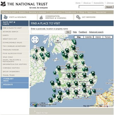
    The hundreds of locations of National Trust owned properties are now available on a Google Map, the large national trust icons are 'clusters of' properties zooming in allows individual places of interest be click-able with summary and open times tabs.


    "
    Welcome to our brand new map."

    "We are still developing this super tool that will help you make the most of your days out with us.

    Let us know whether we're on the right track or if we have room for improvement by leaving some feedback."

    So how does it work?

    • Each small pin represents a National Trust property. Click on the pin and you will get some property information, local weather, travel directions and more.
    • Larger pins represent clusters of places to visit. When you click on one you will get a zoomed-in map showing the area in more detail. Each National Trust property is then shown with a small pin, and as before, you select the pin you are interested in for further information."

    National Trust - Inspirator
    Need Inspiration? Then the "Inspiratior" can help you find a day out - just use your desired location Town or Postcode in the tool and choose a distance.


    Mapperz - leaving feedback:
    Nice work National Trust - now putting both those excellent tools into one box would be a really powerful tool.
    Good for school summer holidays and getting families out into the countryside.


    Labels: , , , , ,

    13 May 2009

    Navteq Maps (Beta)

    Navteq Maps (Beta)

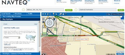
    This is new. Navteq are know for their data but not for their mapping.
    New Navteq Maps Beta 2009
    New from Navteq, Maps not just data.

    "Navteq today launched a beta showcase of its latest road navigation technology, as a clear rival to the Google Maps website"

    Features:
    • Roads Map
    • Satellite Imagery
    • Hybrid Map
    • Routing with directions across the world (77 countries).
    • Live traffic [USA Only] (colour of average speeds coded)
    • 3D fly-through

    Navteq Maps Beta Sign as real
    Simple route London to Reading - with the 'Sign as real' function.

    Note:
    "one-click digital route maps to upload to Garmin, Navman, Navigon and, naturally, Nokia devices. (Nokia bought Navteq in 2007)"

    Navteq Maps Beta Real-time traffic usa only
    Live Real-time traffic USA cities only.

    First impressions:
    is this Map24?
    The more you use it the better it becomes, there is a lot of data behind the scenes.
    Trying to be Google Earth in the web browser?

    Mapperz Source:
    http://www.techradar.com/news/portable-devices/satnav/navteq-launches-google-maps-rival-598436

    Labels: , , , ,

    26 March 2009

    Cartifact Maps (Beta)

    Cartifact Maps (Beta)

    Cartographic Maps made available with Cartfact Labs and Google Maps API.

    Cartifact Maps Custom Map Beta
    Take Google Maps and add your own custom tiles, integrate local search, historic maps (1880, 1928 & 1981) and you get a nice cartographic mashup.

    "Our goal to create a visually enhanced environment for custom cartography focuses on Los Angeles for this beta release."
    Bruce Daniel

    Director, Cartifact Labs

    Cartifact Maps Historic Map Zoom Zens - Local Search
    Lens Zoom - can display historic, Google maps/aerial of Cartifact's own custom tiles.

    Additional Feature
    s:
    Lens control (see image above) - no need to zoom in - the lens does the work
    Local searches on Hotels, Residential Properties and Commercial Spaces.
    Drag zoom.

    Try the Cartographic Mashup - http://maps.cartifact.com/

    Mission
    Cartifact Labs’ mission is to identify, explore and provide expertise in emerging technologies related to the creation and use of maps.

    Labels: , , , , ,

    10 February 2009

    Nokia Maps v3.0 updated (including ovi maps)

    Nokia Maps v3.0 updated (including ovi maps)

    Nokia Maps v3.0 Updated
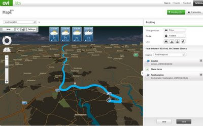
    Nokia Ovi Maps (web browser) now can save routes and sync with your nokia maps v3 - mobile/cell device (sign in required to save routes) - Map in nighttime mode with weather and route.
    • You can rotate the map and view 3D landmarks from all directions.
    • In 3D view mode, you can tilt the view by pressing 2 and 8 button
    • 2D/3D mode works with all map modes, now with Satellite and Terrain
    • My Places has option "Point me to" for any saved place/landmark saves the viewing angle as well.
    • Synchronisation of Favourites and Collections with Ovi Maps and vice versa (use in online mode, enable Internet connection), you can now plan routings on Ovi Maps and synchronise to your device
    Compatibility and system requirements
    Maps Updater and Map Loader 3.0 require Microsoft Windows XP or Vista.
    Maps Updater requires Nokia PC Suite to be installed on your computer.

    Maps 3.0 Beta works with Nokia devices based on:
    S60 3rd Edition Feature Pack 1 (E71, E66, 6110 Navigator, N95, N95 8GB, N82)
    S60 3rd Edition Feature Pack 2 (N96, N85, N79, 6650, 6210 Navigator, 6220 Classic, N78)

    Ovi MapsBeta works on IE6 (Windows XP), IE7, Firefox 2 and Firefox 3 (Windows XP or Vista).

    Note: you cannot use the Nokia Maps 2 and Nokia Maps 3 on the same device. If you have a license for sat-nav (directions/traffic updates etc) you might lose your full licence.
    Backup your device before trying beta software.

    "Your travel guide licences are not valid in the beta version of Maps 3.0. However, the guide licences will be valid again in the final version of Maps 3.0."

    Future implementations (commercial release)
    • Safety spot warner's in selected countries
    • Extended country coverage for Traffic info service
    • Weather information
    • Premium POI content for travel, selected events and cinema
    http://betalabs.nokia.com/betas/view/nokia-maps-30-ovi-maps

    source and many more screenshots:
    http://www.allaboutsymbian.com/news/item/8921_Nokia_Maps_30_beta_updated.php

    Labels: , , , , ,

    02 February 2009

    Google Earth 5 (Beta) More New Layers

    Google Earth 5 (Beta) More New Layers

    KML Update:
    The KML documentation has now been updated for users wanting to create tours underwater.
    http://code.google.com/apis/kml/documentation/kmlreference.html#kmlextensions

    Official Posts
    http://google-latlong.blogspot.com/2009/02/new-in-google-earth-50-historical.html

    http://google-latlong.blogspot.com/2009/02/deep-dive-into-ocean-in-google-earth.html

    http://googlegeodevelopers.blogspot.com/2009/02/ocean-time-machine-and-touring-new-kml.html

    Google Earth 5 New Layers
    Google Earth 5 - Real-time buoys data provides current conditions the ocean.

    "If you've ever wondered how your neighborhood has changed throughout time, Google Earth now gives you access to the past. With a simple click, check out suburban sprawl, melting ice caps, coastal erosion, and more."

    Google Earth 5 New Layers

    New toolbar gives easier access to control features
    Dive beneath the surface of the ocean

    In the new ocean layer, you can plunge all the way to the floor of the sea, view exclusive content from partners like BBC and National Geographic, and explore 3D shipwrecks like the Titanic.

    • Dive beneath the surface and visit the deepest part of the ocean, the Mariana Trench
    • Explore the ocean with top marine experts, including National Geographic
    • Learn about ocean observations, climate change, and endangered species
    • Discover new places including surf, dive, and travel hotspots and shipwrecks
    Track and share your paths with others

    Take placemarks a step further and record a free-form tour in Google Earth. Simply turn on the touring feature, press record, and see the world. You can even add a soundtrack or narration to personalize the journey.

    Please Visit the Excellent http://www.gearthblog.com

    for more detailed and in depth information on the newest release of Google Earth.

    Historical Imagery
    New Google Mars
    New Google Ocean

    To Download Google Earth 5 go:
    http://earth.google.com/ocean/
    **High Speed Broadband recommended if using this free product.

    Labels: , , , , ,