->

12 February 2010

Google Maps Gets Beta Labs

Google Maps Gets Beta Labs
*Google Account signin required
Google Map has now enabled Google Labs experiments that you can now add some nice and useful functionality.
Google Maps Labs Rotated
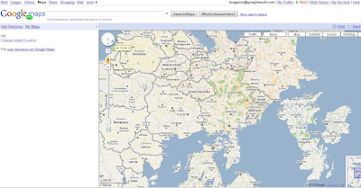
A new prespective - Note the Map Labels (Text) are correct way up but the map is upsidedown.

Google Maps Labs New
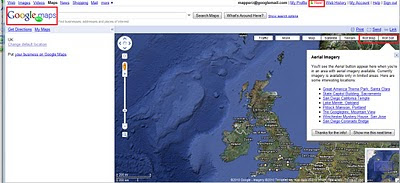
New Features and Tools in Google Maps via Google Maps Labs - Rotate Map Types (Sat

Google Labs experiments that you can now add the following functionality:

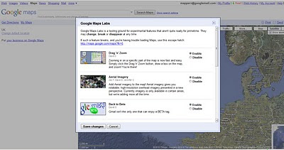
Drag 'n' Zoom
Zooming in on a specific part of the map is now fast and easy. Simply click the Drag 'n' Zoom button, draw a box on the map.
Google Maps Labs

Google Maps Labs Drag Zoom
New Button for Drag Zoom - Useful!

Click on the Green beaker New! to access the new features (simliar to gmail labs)

The Options are as follows
Aerial Imagery (Includes Rotate)
Add Aerial imagery to the map! Aerial imagery gives you rotatable, high-resolution overhead imagery presented in a new perspective. Currently imagery is only available in certain areas, but we're adding more all the time.

Back to Beta
Gmail isn't the only one that can enjoy a BETA tag.

Where in the World Game
Test your knowledge of world geography. Guess the name of the country from satellite imagery, and try to beat your top score.

Rotatable Maps
Tired of North always being up? Add rotatable map types and give East, West and South a fair go.

What's Around Here?
Adds a second search button that searches for "*", returning the top results in the current view. A great way to browse the map.

LatLng Tooltip
Displays a tooltip next to the mouse cursor showing the latlng directly underneath it.

LatLng Marker
Adds an option to the context menu that lets you drop a mini marker showing the latlng of the position that the cursor was pointing at when the context menu was evoked.

Smart Zoom
Ever zoom in too far and get the message "We don't have imagery at this zoom level"? Ensure you don't see it again, with Smart Zoom, which will check in advance what imagery exists, and ensure you can't zoom in beyond it.

source:
http://blogoscoped.com/archive/2010-02-12-n86.html
Related
http://googlemapsmania.blogspot.com/2010/02/google-maps-in-google-labs.html
Official Post
http://google-latlong.blogspot.com/2010/02/introducing-google-maps-labs-your.html

Labels: , , , , , ,

26 June 2008

Google Map Maker

Google Map Maker

Google Map Maker
Google is now allowing certian areas in the world to be edited by the user


"Google Map Maker is a Google Maps service that allows you add or edit features, such as roads, businesses, parks, schools and more"


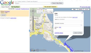
Google Map Maker displays in your web browser. The service appears similar to Google Maps, but displays a set of tools that allows you to mark locations and add information. These tools

New Tools allows you to edit content live - but requires a 'google' review before making it to google maps tiles.

Use the Placemark tool to mark a location such as a business or school.
Use the Line tool to mark roads, rivers, etc.
Use the Polygon tool to mark regions, such as a park or neighbourhood. You can enter similar information as with the Placemark tool, but the Polygon tool enables you to mark an entire area.


Scale Dependant for Editing Mode
You need to zoom to a range of 50m to 1km to be able to use Google Map Maker tools. If you use see these tools, try zooming in. To zoom in, use the zoom slider, mouse scroll wheel or right click > Zoom in. To center a point on the map, right click on the appropriate location and choose Center the map.

Metadata (information about the data)

Overview - Basic information about the feature. (name, address, etc.)
Attributes - Specific details about the feature. (road speed, driving direction, photo URL, etc.)
Description - Longer description and comments for reviewers. For example: Comment to moderator - This building has been torn down recently.
Events - Occurrences that pertain to the feature (such a concert that occurs in a park)
History - Record of past edits to the feature (changes made by other users)

Available Locations to be edited (Subject to change)

Antigua and Barbuda
Bahamas
Barbados
Bermuda
British Virgin Islands
Cayman Islands
Cyprus
Grenada
Iceland
Jamaica
Netherlands Antilles
Pakistan
St. Kitts and Nevis
St. Lucia
St. Vincent and the Grenadines
Trinidad and Tobago
Vietnam


Note on Privacy
While you may mark your home on the map by adding the same as a point of interest, Google suggests that you do not reveal such private information in Google Map Maker.
Consider marking it as a Point of Interest

More on this visit
http://googlemapsmania.blogspot.com/2008/06/google-map-maker.html
http://www.google.com/mapmaker/mapfiles/s/support.html
http://google-latlong.blogspot.com/2008/06/making-your-mark-on-world.html#links

Mapperz

Labels: , , , ,

05 December 2006

Ask City Maps

New Ask City Maps
Ask City Maps UK

New Mapping from Ask.com and CitySearch
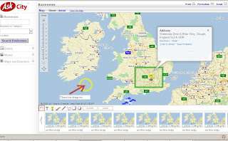
Drawing Tools make it easy to add graphics to the map point(icon), line (freehand available), polygons and text.

Good you can save snap shots of your cartographic skills (mapperz was playing!)

AskCity is a search service that allows you to find Businesses, Events, and Movies for most cities in the U.S. Ask combines these features with a number of other helpful services, such as:
  • Driving and walking directions
  • Drawing tools so you can mark places on your map and add text notes
  • Editorial and user reviews of local businesses, concert halls, movie theaters and more
  • Options that allow you to save one location while you search for another one on the same map
  • "Save Map" option that allows you to save up to ten of your maps
But also works in the UK, Road Classifications shows maximum speed for that Road.
(note speed limit in Richmond Park is 20mph now UK does not have a 25mph limit)

Ask Map Richmond Park Speed Classifications

To make your map click here

Labels: , , , , ,