->

21 October 2011

Nokia Maps WebGL (Beta)

Nokia Maps WebGL (Beta)

Nokia Maps WebGL - Toronto, Canada

Using Google Chrome Nokia Maps WebGL is extremely smooth and fast rendering 3D Buildings with photo-realistic  quality, on par with Google Earth Desktop

WebGL (Web-based Graphics Library) is software hat extends the capability of the Javascript programming language to allow it to generate interactive 3d Graphics within any compatible Web Browser. WebGL code executes on a computer Graphics card's(GPU), which supports shade rendering.

To try this - use the latest version of Google Chrome.

Nokia Maps WebGL:


19 October 2011

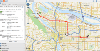
Multi-modal Trip Planner OSM - Portland

Multi-modal Trip Planner OSM - Portland


Underlying Data is Open Street Map

Multi-modal trip planners can create routes that mix different modes of travel. Not only can users plan a transit-only trip or a bike-only trip, they can also plan a mixed mode trip—like biking to the train and then continuing by train to their destinations.

Portland Regional Trip Planner
The new Portland Regional Trip Planner is a multi-modal trip planner funded by a pair of Metro Regional Travel Options Grants (2009-11 and 2011-13). October 15, 2011 is the formal launch date for TriMet’s beta release of the new trip planner and marks the first official deployment of a fully open source / open data trip planner by a major U.S. transit agency. RTP will replace TriMet’s transit-only trip planner after the beta test period of 3-6 months.
The technology behind RTP is called OpenTripPlanner. OpenTripPlanner’s worldwide developer community and broad user base has many advantages. As OpenTripPlanner improves, the Regional Trip Planner will improve. For more information about OpenTripPlanner, visit https://github.com/openplans/OpenTripPlanner/wiki/.

FUTURE DEVELOPMENT (upcoming features)

These are some of the new exciting new features worked on due in a couple of weeks:

    Printer-friendly itineraries and maps
    Aerial imagery in the background (as a base map)
    Trips involving multiple transit agencies
    Elevation display for pedestrian trips
    Ability to modify biking trips by dragging the route on the map
    One-click switch between modes of travel for planned trips
    Incorporating real-time transit information instead of schedules
    Improved pedestrian routing using safety and accessibility data
    Driving directions to transit centers and park-and-ride facilities

Try the Trip Planner Map

13 October 2011

New Google Maps WebGL

New Google Maps WebGL  (Preview)

3D Buildings - Seamless zoom into Streetview

Available for FireFox 8 and Google Chrome14 (WebGL Enabled)

To enable use the:

Want to try something new? Button

  • Take MapsGL, our new experimental maps experience, for a spin
  • 3D buildings and seamless 45° aerial view rotations
  • 'Swoop' quickly from the map view to Street View imagery, without a plugin
MapsGL is our experimental Maps technology powered by WebGL, and has certain system requirements.


Seamless 45 degree Oblique Aerial images for specific cities (Rome here).
 Source:


UK Crash Map

UK Crash Map 


CrashMap has been developed by a very experienced team of collision analysts and road safety professionals with extensive experience of making road casualty data available to the press and public especially online.

Once the Department for Transport permitted public access to the road casualty data it was a natural next step to provide a useful and usable tool to facilitate this. Our vision was to create a way in which the public, who often have a very genuine interest in what happens on roads in their area, could easily lay hold of the most relevant information to them with a few clicks of a mouse; we hope you find CrashMap useful.

CrashMap uses data collected by the police about road traffic crashes occurring on British roads where someone is injured. This data is approved by the National Statistics Authority and reported on by the Department for Transport each year. This site uses data obtained directly from official sources but compiled in to an easy to use format showing each incident on a map. Incidents are plotted to within 10 metres of their location and as such, can sometimes appear to be off the carriageway. The CrashMap team accept no responsibility for errors within the data and all queries relating to accuracy should be directed to the appropriate authority. If you would like to understand more about how the data is collated and reported please visit the Department for Transport’s publication Reported Road Casualties Great Britain.

The data includes all incidents up to the end of 2010
and will be updated as soon as the latest data is released by the Department for Transport (which happens around the end of September every year).

To make each report as accessible as possible to users of the site, the report is broken up into 2 clear sections.

Part 1 deals with the information that you are most likely to want to understand about the incident such as when it happened, at what time of day, how serious was the incident, how many vehicles were involved, how many casualties were there, what type of road was it on or what was the weather like.

Part 2 (login required) then provides much more detailed information if you need it about each vehicle and casualty to allow you to get an understanding of the types of vehicle, the gender and age bands of any casualties, the gender and age bands of any drivers, what manoeuvre the vehicle was performing at the time of the incident.

UK Crash Map

05 October 2011

MapQuest Mobile Flash Maps API

MapQuest Mobile Flash Maps API

A new Mapquest API combined with an Adobe Flash technology

You can deploy native mobile applications to Apple iOS, Google Android and Blackberry Tablet from a single code base.
 
Traffic incidents along a route (New York to Washington DC)

Our Mobile Flash Maps API provides interactive mapping features to use within Flash Builder 4.5 native mobile applications.  This includes support for touch gestures, as well as making our controls and POIs mobile friendly. So now you can easily combine the great features of our web services, such as searching for traffic or optimizing your route, with an easy way to deploy to a mobile device.  Check out the video below to see just a small sample of what you can do.

Some features you might be interested in.
Source and more information:
http://devblog.mapquest.com/2011/10/03/mapquest-launches-mobile-flash-maps-api/