->

25 October 2007

EveryScape - "Street View" Like Map

EveryScape - "Street View" like map.

Another very good application that works on similar lines to Google Maps StreetView
but it goes further - into plazas, squares and shops.EverySpace
using the 'You drive' you can control your destination either click on the map (inside the polygon zone) or use the 'Go' icons on the EveryScape viewer.


"EveryScape is the only place you can discover your everyday world, your way. Today, you can check out Union Square, San Francisco as the first city to be scaped. You can check out restaurants, hotels, go shopping, drive by homes. You can see what other people are saying and share your comments as you stroll down the street. Click on the link to the right to vote for the next CityScape — it could be yours."

similar to the excellent MapJack

Try it out http://www.everyscape.com/

Labels: , , ,

23 October 2007

A GPS Jacket on sale

A GPS Jacket on sale in the UK for £350

Trail Blazer GPS Jacket

  • GPS technology provides updates every 10 seconds
  • Firm says garment gives young more independence

Not sure on this...
So for your first year that is £350+£120 (£470)

If had a lifejacket (life preserver) option this would be more useful.

There is a children's version for £250+£170 for the paranoid parent.

So now there are trainers (sneakers/runners), Jackets. Next GPS trousers (pants)?

direct links
http://www.bladerunner.tv/product/details.php?id=trlbzr

http://www.bladerunner.tv/product/details.php?id=CHILDRENS

for that price I would want the 'drying mode' and 'self adjusting mode' of the 'back to the future' (part II) jacket

Source Guardian Unlimited
http://www.guardian.co.uk/technology/2007/oct/23/news.crime

Labels: , , , ,

22 October 2007

MapCruncher (VE beta Version) +Quick Guide

MapCruncher (VE beta Version) Quick Guide
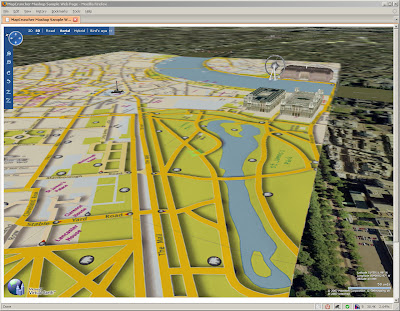
Custom Map in 3D MSVE
Your own Custom Map in Virtual Earth in 3D (London is a bit too flat) Buildings are from Microsoft Virtual Earth.

What is it?
Crunches Maps!
Generates Custom tiles in from one image into tiles at different zoom levels

Okay what do I need?
MapCruncher VE version (beta)
some space on your pc
*not much knowledge on web programming

.net version 3.0 framework is required to use this program (but it's worth having anyway)

How to use it
have a digital version of your map - and make sure you have copyright on the map source.
(tif,gif.jpeg,pdf,png can be used.)
at least 150dpi, try at 300 and your map will be clearer (less fuzzy)


Georeference the image - this shows you how - at least 3 points are needed - 4 is best.
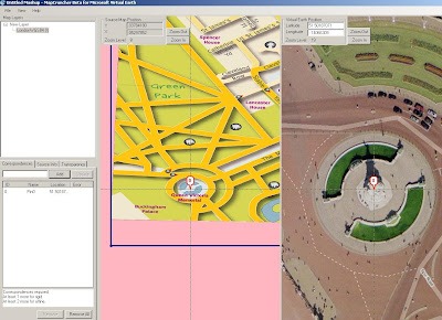
Map Cruncher Georeferencing
locate both 'locations' and add a marker on virtual earth base, once three locations are done it can be locked.

Lock the Image to the Virtual Earth (VE) map

Rendering.... THE MAP CRUNCHING BIT! (can take a while with big images) - this one took 20 minutes.
The good thing here is that it is an automated process - only 'map crunching' computer time
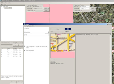
Map Cruncher Rendering
This is automatic - just have a new folder for the images and html to go.


This even creates a sample html page to get you up and running.

But I want 3D!

OK you cannot view 3D on your local computer - but you can if the 'map crunched' data is uploaded to a webserver (http only)

File sizes - ok the little issue here is that many images created for zoom and panning.
This map is 236MB so it can take a while to upload to a webserver..

But then once on the webserver - you can view it in 3D

try
http://www.mapsinternational.co.uk/ve/samplepage.html
try and let the image load up first (post-cache)

(ok, ok London is a bit flat!)

But this can be done for more undulating areas!

Can this be used for other mapping API's?
Looking into this using Google Maps API, Multimap API and Yahoo Maps API.
(in theory yes)

Mapperz

Labels: , , , , , ,

17 October 2007

Microsoft Virtual Earth Version 6 - Released

Microsoft Virtual Earth Version 6 - Released

What is it?
"Virtual Earth provides the power behind Live Search Maps, an online mapping service that enables users to search, discover, explore, plan, and share information about specific locations. By using traditional road maps, labeled aerial photo views, low-angle high-resolution aerial photos, and proximity searching capabilities, Virtual Earth provides unique opportunities for developers to incorporate both location and local search features into their Web applications."


(Finally the video uploads! - from Space to the Grand Canyon)
This is a Powerful 3D Engine - You can use it like 'Google Earth' but this is in a web browser (Firefox here with the 3D plugin already installed)

Whats is New? (lots)

Version 6.0 of the map control includes improvements in the following areas:
  • Enhanced accuracy
  • Additional functionality
  • Enhanced performance (it is a lot smoother
  • Enhanced Geocoding. Integrates multiple geocoders and datasets.
  • Rooftop Geocoding. Rooftop locations are the most precise geocoding.
  • Consistent Pushpin Accuracy. When switching between aerial and Birdseye views.
  • Multi-point Routing. A new method takes multiple points for a route
  • Switching from Miles/Kilometers available
  • Bulk Addition of Shapes. A new method to add multiple pushpins in one call.
  • Improved Shape Control. You can now specify how a shape object appears relative to other shapes or tile objects, providing greater control in viewing data and objects.
  • MapCruncher (Beta). MapCruncher Beta for Microsoft Virtual Earth makes it easy to publish maps overlaid in an application using the Virtual Earth map control. See the MapCruncher Web page for further information.
  • 3D Altitude Settings. Altitudes for three-dimensional objects can now be specified in meters.

There have been significant speed and accuracy improvements for pushpins and shapes in high numbers. Performance enhancements also include faster map panning.


MapCruncher Beta for Microsoft Virtual Earth makes it easy to publish maps overlaid in an application using the Virtual Earth map control. Once you are familiar with the tool, it will take you about ten minutes to generate a new tile layer. Just find 5 to 10 corresponding landmarks on your map and on the Virtual Earth map view, and MapCruncher will register your map to the global coordinate system, warp it to fit a Mercator projection, and generate a set of image tiles that can be seamlessly layered on top of Virtual Earth map control's standard road, hybrid, or aerial imagery. It even makes a sample HTML page for reference. MapCruncher accepts a variety of vector formats (PDF, WMF, EMF) and raster formats (JPG, PNG, TIFF, GIF, BMP). Where to get more information?
Start here http://dev.live.com/virtualearth/sdk/ test the functions out.
http://blogs.msdn.com/virtualearth/


Download the SDK Version from http://msdn2.microsoft.com/en-us/library/bb429619.aspx

More Blogs detailing the features
http://blogs.msdn.com/keithkin/archive/2007/10/17/virtual-earth-v6
-api-now-available.aspx

upgrading from version 5?
http://www.nateirwin.net/VirtualEarthMapControlV6Released.aspx


Labels: , , , , ,

16 October 2007

New Live Maps - Goes Live +KML Overlay

New Live 'Search' Maps - Goes Live

New Live Maps
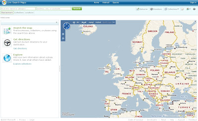
New cleaner version of Live Search Maps

and the 3D gets smoother....

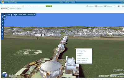
New Live Maps Brighton in 3D
Brighton Pier in 3D in FireFox.

Look for the Loader
3D Loading Rendering Progress
The Globe show the data loading/rendering for the view.

quick guide -

Shortcut keys...
Home [Button] - Birds Eye -straight down
Page up [Button] - Zooms Out
Page Down [Button] - Zooms in
Cursor keys - Pan in keys direction
Shift - Pivot on that location
Control (Ctrl) Key - tilts and rotates (with mouse)
B - Birds Eye View

Click 'N' (North) on the controls resets the direction to North.

Control and Shift keys can be use with the mouse.

Have a Play - http://maps.live.com/


Some more details coming out.

Codenamed Gemini is Version 2 of Live Maps based on the Virtual Earth 6 Engine

New Features include KML overlay (a global accepted spatial dataset now?)

Seems only points are supported so far here is an example

Google Maps KML overlay

Now Live Maps KML Overlay

Same KML URL but the route(polyline) is missing - though does allow you to subscribe to the KML via RSS

Much more information in more detail is available from the official blog
http://virtualearth.spaces.live.com/default.aspx?wa=wsignin1.0

Google Earth Blog has a very good articial on Basic KML supported by Microsoft
http://www.gearthblog.com/blog/archives/2007/10/microsoft_virtual
_earth_supports_ba.html


Mapperz

Labels: , , , , , , ,

14 October 2007

Massive Live Local Maps and Imagery Updated

"Birds Eye views of dozens of cities around the world were added to the Virtual Earth platform last night. You can enjoy them at Live Search Maps or integrate them into your own applications with our Map Control. 10TB of new imagery went out in this release along with 28TB of refreshed street map tiles. The October imagery release is one of the largest for Birds Eye in a while, featuring coverage in Madrid, Stockholm, Copenhagen, plus 15 regions in the UK and US respectively (see below for full list) "


1 Terabyte = 1024 Gigabytes


(ensure 3D Virtual Earth Plugin is installed with IE7 before clicking the links)


Source:


http://virtualearth.spaces.live.com/Blog/cns!
2BBC66E99FDCDB98!9246.entry?action=post&wa=wsignin1.0

Labels: , , , ,

11 October 2007

Compare OpenStreetMap vs Google Maps Data Sources

An Update:Topologically Integrated Geographic Encoding and Referencing TIGER Data going into OpenSteetMap -
http://www.linux.com/feature/119493
  • with experience with TIGER data, towns and cities have fairly good data, though in more rural locations the data is of less (made up in some places) quality.
  • 'paper roads' can exist - where the roads have been planned but don't physically exist.
  • Poor positional accuracy has however made it extremely difficult to integrate TIGER with advanced technologies and data sources such as GPS, high resolution imagery.
  • The positional accuracy of TIGER road centerline can be improved from an original 100 plus meters using a method called 'conflation'(See Cartography)
Stats on the loading http://dev.openstreetmap.org/~daveh/tiger/stats.html

current stats
"We are processing 6.212597 OSM objects per second at this rate of upload, the entire US will be done in: 27401872 seconds or 317 days or 0.868313 years on Sun Aug 24 12:27:57 2008"


OpenStreetMap vs Google Maps Data Sources - who do you trust?

This is a very interesting topic and compares commercial products (TeleAtlas) with community captured data (OpenStreetMap)

Note: All Maps are to an extent wrong/or out of date, but having a good baseline of cleaned digital data is a very good start.

RefNum has produced set of 'editorial' markups showing the differences and even for a small town there are a number of striking ones.
Haywards Heath Errors - KML Overlay
In detail on Hayward's Heath is a KML Overlay highlighting errors.


Comparing TeleAtlas Google Maps with Open Street Map
geo.topf.org
has side by side comparison of Google Maps and Open Street Map (MapNik Styled)

"This is an attempt at generating nice map tiles for slippy maps at low zoom levels which can then be combined with OpenStreetMap tiles from higher zoom levels.
The information in the OpenStreetMap database is intended for higher
zoom level and doesn't work well when viewing the whole world or a whole continent."
Jochen Topf
http://geo.topf.org/contact.html

So the future looks good for community based mapping data (open source free mapping).
Commercial digital data capture companies have the edge for coverage at the moment. But the more the people and small companies that join in the faster the benefit to all.
It will not put out business to business mapping but for 'Joe Public'
without the threat of breaking licencing infringements to produce maps for personal/club/internet usage.

Interested in this Project?
Then head to OpenStreetMap


Source:
http://www.opengeodata.org/

Mapperz

Labels: , , , , , ,

10 October 2007

Google Maps Street View - New Feature

Google Maps Street View - New Feature- now look up

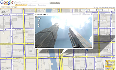
Now you can check out 360-degree views of Chicago(IL), Pittsburgh (PA), Philadelphia (PA), Phoenix (AZ), Portland(OR) and Tucson(AZ). As an added bonus, the images in Phoenix, Tucson and parts of Chicago are all in high resolution.
Plus you can pan within the Streetview mode and look up at tall buildings.

Sears Tower - StreetView - Now Look Up

Two Official Posts on this (one with a karaoke video)
http://google-latlong.blogspot.com/2007/10/
more-street-view-cities-to-explore_09.html(updated)

http://google-latlong.blogspot.com/2007/10/
more-street-view-cities-to-explore.html

Labels: , , ,

08 October 2007

4D Data in ArcGIS Explorer

4D Data in ArcGIS Explorer - Timeline

"Time Navigator can animate any ESRI Shapefile with point geometry and a timestamp field. The timestamp fields can be date, numeric or textual. Time Navigator is developed as a custom task for ArcGIS Explorer build 410 and can be downloaded from downloaded from ArcScripts (source code is included)." mrrichie


Source: Ogle Earth

Labels: , , , ,

07 October 2007

Woodland Trust - Ancient Trees Map

Woodland Trust - Ancient Trees Map - for the UK

"Ancient trees are living relics of incredible age that inspire in us feelings of awe and mystery. We reveal what makes a tree truly ancient, unlock a few of the fascinating secrets and stories associated with them and help you discover why they can sustain such a wide variety of wildlife."Ancient Tree Hunt

Ancient Tree Hunt
This custom built map is a good example on how to have your own custom map and still achieve
highly interactive content. Based in Flash the map is easy to use and has a 'drill down' on data, getting more detailed as you zoom in. More layers become available in the side bar when your in particular areas and zoom levels.

Currently there are 3410 verified ancient trees available

Other layers of data are available:
  • Protected Areas
  • Sites of Special Scientific Interest
  • Areas of Outstanding Natural Beauty
  • National Nature Reserves
  • Local Nature Reserve
Other valuable information is also given whether is private or has access to pubic.
  • Car Parks
  • Footpaths
  • Information Points
  • Entrances
  • Cycle Routes
To use the interactive map (in flash) go to
http://www.ancient-tree-hunt.org.uk/Discoveries/interactivemap?
and zoom into your area of interest.

Nice touches through out - print for personal use and the find works as it should.
Even the little flash intro (not too long) of leafs falling is a visual guide that something is happening.

*Note the 'Zoom Bar' is back to front - compared to conventional mapping applications out there.
Mapping has been created by DrawLive Ltd

Mapperz

Labels: , , , , , ,

05 October 2007

Real-Time Travel Information Map - Leeds

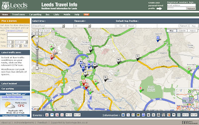
Real-Time Travel Information Map - Leeds

The Map shows the location of all traffic affecting Road Closures, Roadworks and Planned Events active now or in the near future.

Leeds Travel Information Map
An excellent 'mashup' using numerous data sources including BBC Backstage and Leeds City Council.

Tips on Use: If the map looks cluttered when you visit first use the content panel and switch off all then click individual icons for that layer to be displayed.
Also available is a set your last selected default map position and also remembers your last selection of travel information types and time.

Full Features of the Leeds Travel Information Map
  • Map: the map shows the locations of all traffic affected by road closures, roadworks and planned events that are active now or in the near future
  • Car Parking: A list of up to the minute information on car parking spaces
  • Travel News: This tab contains a searchable list of all traffic affecting road closures, roadworks and planned future events.
  • RSS Feeds: subscribing to the RSS feeds you can receive up to the minute travel information of your choice for the Leeds area
  • Mobile Services: live travel information to mobile phones with Google Maps for Mobile
More Information from the Help Guide
and for a Full Legend for the Map Icons go to the Key

Leeds Travel Information Map


More like this please! Mapperz

Labels: , , , , ,

New Improved Microsoft Live Maps Soon

Update 16/10/2007
This is now live to all
New Post
http://mapperz.blogspot.com/2007/10/new-live-maps-goes-live.html

Nearly New Microsoft Live Maps

Live Search Maps Preview
Image Source LiveSlide
They have listened to users feedback and have released a few 'sneek' peek improvements.

Live Maps Preview

Whats changed?
  1. The second confusing search box is gone.
  2. The map control moves to the upper left corner
  3. more too be announced ... (support for KML geothought thinks so?)

Major improvements in traffic and driving directions includes
  • directions with either the start or the finished directions compressed.
  • another directions improvement is a traffic re-director based on real-time traffic data.
  • one click directions if you are inviting others to an event,supports multiple starting points
  • 1-click directions will show directions from the North, South, East, and West

3D Improvements
  • incorporating Birds Eye photography pictures directly into the 3D map
  • a new way to create 3D collections that "flyover" of collection points

More new features and improvements pending - reportedly due in couple weeks.

More screen shots and details at LiveSlide.net

Also Version 6 of the Virtual Earth Map Control is soon to be released, good news for developers of Custom Live Maps.

Mapperz

Labels: , , , , ,

04 October 2007

Google Maps includes Transit Data

Google Maps includes Transit Data


Formally they only way to access this for the 21 (most in the US) cities was via
http://www.google.com/transit

But it seems from today that is now available via the Google Maps main portal.
Google Maps Now Includes Transit Data
It's a good way to help get information to the user, real-time traffic can also be overlayed to see any potential delays.

The coverage hopefully expands and in due course 'city' commuters will be able to access it via mobile devices.
No European Cities to date.


try it out here:
http://www.google.com/maps?f=d&hl=en&geocode=
&time=&date=&ttype=&saddr=university+washington
&daddr=robinswood&sll=47.598755,-122.199554&sspn
=0.10441,0.32135&dirflg=r&ie=UTF8&ll=47.651281,
-122.202301&spn=0.13414,0.32135&z=12&om=1&layer=t&start=0
(time for tinyurls google?)

Mapperz Source:
http://blogs.zdnet.com/BTL/?p=6507

Now there is an Official Post from Google LatLong Blog on this topic.

Labels: , , , , ,

02 October 2007

'At-Risk' Post Office Outlets Mapped

last update:
Yorkshire area
http://mapperz.googlepages.com/yorkshire_post_offices
_at_risk_name.html


Outreach Post Offices Planned (replacing these Post Offices)
http://mapperz.googlepages.com/outreach_post_offices_named.html

data from...
http://news.bbc.co.uk/1/shared/bsp/hi/pdfs/02_10_07_po_total.pdf
so if that is wrong so will the location on the map

update:

Midlands is Mapped now.
http://mapperz.googlepages.com/Midlands_post_offices
_at_risk_named.html
*Starkholmes, 133 Starkholmes, Road Matlock E4 5JA was not mapped due to an incorrect postcode.

Kent 'at-risk' Post Office Outlets Mapped


"The Post Office has announced the first 180 branches earmarked for closure under its plan to shut 2,500 by the end of next year."

based on the pdf on the BBC website - Mapperz mapped them. In 15 minutes
http://news.bbc.co.uk/1/hi/uk/7023244.stm


How was this done so quick?

  • Copy and pasted addresses and postcodes from the PDF into notepad, save as .txt
  • Rename as .csv
  • Open this in OpenOffice (or Word) as comma delimited.
  • Adjusted the Postcodes into one column
  • Appended the lat/lng to the Post Office 'at risk' in OpenOffice
  • Saved as .xls
  • Published this as 'public' (will not work if your don't)
*to create the link between the spreadsheet and google map via the Public Spreadsheet Key.
**the wizard does do a lot of things, icons sizes, colours, viewport, map extent based on data.
The Mapperz modified a little html to make the map centre on Europe before zooming to the Kent era.

View the 'At Risk' Post Offices in Kent Map

Mismatched postcodes with the geocoder
Kent had one Postcode that was incorrect replacing the 'I' for a '1' worked.
TN13 IHZ should be TN13 1HZ

Labels: , , , , , ,

01 October 2007

UK Bluetongue Map

UK Bluetongue Map showing Control Zones in the UK

Bluetongue Map
Blue Range Rings 20km
Red Polygon Simplified Control Zone
Black Polygon Simplified Protection Zone

Cause?

"Transportation of the virus by midges is believed to have occurred on a Southeasterly wind from the continent.

Thetford has been selected as a centre point of East Anglia and the centre point of the range rings that are spaced 20km apart.
As the map shows spread of the virus is greatly affected by climatic conditions such as wind and temperature.
As wind direction is a significant factor in the spread of the virus, winds from the Northeast and Southeast quadrants pose the greatest risk of the virus spreading, along with a mild winter.
DEFRA control zones could very well change on a daily basis so farmers are well advised to check with DEFRA on the latest situation.

Please check the map (gets updated).
http://www.gis-logic.co.uk/bluetongue.htm

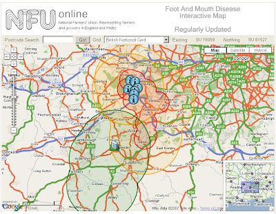
Also available is nice interactive version for Foot & Mouth
http://www.gis-logic.co.uk/footandmouth.htm
Foot and Mouth Map
Red Circle/Polygon: Foot and Mouth Protection Zone
Orange Circle/Polygon: Foot and Mouth Surveillance Zone 10KM
Dark Green Circle/Polygon: Lifted Zones

No Mapperz does not have Bluetongue or Foot and Mouth. But this map is a better solution than defra pdf and slightly interactive maps.

Please refer to Defra for up to date information.

Labels: , , , , ,