MapCruncher (VE beta Version) +Quick Guide
MapCruncher (VE beta Version) Quick Guide

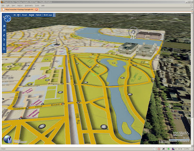
Your own Custom Map in Virtual Earth in 3D (London is a bit too flat) Buildings are from Microsoft Virtual Earth.
What is it?
Crunches Maps!
Generates Custom tiles in from one image into tiles at different zoom levels
Okay what do I need?
MapCruncher VE version (beta)
some space on your pc
*not much knowledge on web programming
.net version 3.0 framework is required to use this program (but it's worth having anyway)
How to use it
have a digital version of your map - and make sure you have copyright on the map source.
(tif,gif.jpeg,pdf,png can be used.)
at least 150dpi, try at 300 and your map will be clearer (less fuzzy)
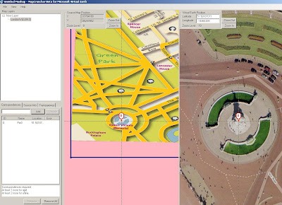
Georeference the image - this shows you how - at least 3 points are needed - 4 is best.

locate both 'locations' and add a marker on virtual earth base, once three locations are done it can be locked.
Lock the Image to the Virtual Earth (VE) map
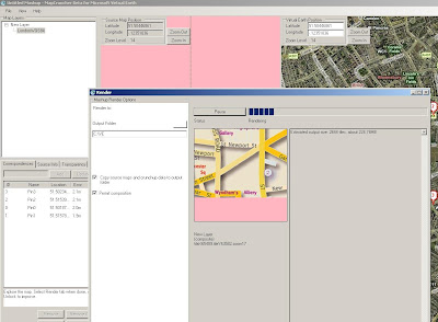
Rendering.... THE MAP CRUNCHING BIT! (can take a while with big images) - this one took 20 minutes.
The good thing here is that it is an automated process - only 'map crunching' computer time

This is automatic - just have a new folder for the images and html to go.
This even creates a sample html page to get you up and running.
But I want 3D!
OK you cannot view 3D on your local computer - but you can if the 'map crunched' data is uploaded to a webserver (http only)
File sizes - ok the little issue here is that many images created for zoom and panning.
This map is 236MB so it can take a while to upload to a webserver..
But then once on the webserver - you can view it in 3D
try
http://www.mapsinternational.co.uk/ve/samplepage.html
try and let the image load up first (post-cache)
(ok, ok London is a bit flat!)
But this can be done for more undulating areas!
Can this be used for other mapping API's?
Looking into this using Google Maps API, Multimap API and Yahoo Maps API.
(in theory yes)
Mapperz
Labels: 3D, Beta, Georeferencing, Guide, MapCruncher, Rendering, Virtual Earth


6 Comments:
have yet to play about with MCruncher (work computer not net 3.0) but would be interested if it works with google maps.
So, if as a contractor, you purchased a license to use OS data (Mastermap, 50k, etc.) Would I have the right to use MC to upload it and use it to deliver data overlaid onto the OS mapping to a client within G-Maps/MS?
Once you have rendered your files you can use this application http://rootcamp.net/crunchup2kml to convert it into a KML to use in Google Earth!
If you purchased an OS data licence you could use it. As long as the licence is for commercial web. That is not cheap.
Have 'crunched' an OS Map for a test and works out well. You don't even need to project the data into WGS84.
Rob nice App - looking into it.
Mapperz,
Its easy to use MapCruncher for GoogleMaps.
I put a bit on the Mapki about it around a year ago. See
http://mapki.com/wiki/Map_Cruncher
Bill thanks, I have seen the Mapki, though testing still.
Want transparencies so either setting it 50% in a photoshop action (adds watermark too).
Or add an opacity slider to the custom layer.
The world map that is getting crunched produced 4 gb of pngs...
need to reduce that or get a bigger ftp pipe to the webserver.
I have put some fairly detailed instructions about using MapCruncher for GoogleMaps at
http://www.bdcc.co.uk/GoogleCrunch/Crunch.htm
Post a Comment
<< Home