Real-Time Travel Information Map - Leeds
Real-Time Travel Information Map - Leeds
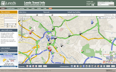
The Map shows the location of all traffic affecting Road Closures, Roadworks and Planned Events active now or in the near future.

An excellent 'mashup' using numerous data sources including BBC Backstage and Leeds City Council.
Tips on Use: If the map looks cluttered when you visit first use the content panel and switch off all then click individual icons for that layer to be displayed.
Also available is a set your last selected default map position and also remembers your last selection of travel information types and time.
Full Features of the Leeds Travel Information Map
- Map: the map shows the locations of all traffic affected by road closures, roadworks and planned events that are active now or in the near future
- Car Parking: A list of up to the minute information on car parking spaces
- Travel News: This tab contains a searchable list of all traffic affecting road closures, roadworks and planned future events.
- RSS Feeds: subscribing to the RSS feeds you can receive up to the minute travel information of your choice for the Leeds area
- Mobile Services: live travel information to mobile phones with Google Maps for Mobile
and for a Full Legend for the Map Icons go to the Key
Leeds Travel Information Map
More like this please! Mapperz


0 Comments:
Post a Comment
<< Home