->

13 October 2010

Travellerspoint.com

Travellerspoint.com helps you plot future and past trips on a map. Control trip colours, curves, transport modes.

"The goal of Travellerspoint is to create an international meeting point for travellers worldwide, whether they are planning their travels, currently travelling or have returned from their travels and want to stay in touch with (or find) those travel friends they met while travelling in the past."

TravellersPoint.com Map

http://www.travellerspoint.com/guide/

Labels: , , , , , ,

18 June 2008

MAPme.com - A Community Based Mapping Project

MAPme.com - A Community Based Mapping Project
Mapme Logo

MAPme.com a social mapping site which allows everyone from travelers to special interest groups to create and contribute locations by suggesting 'Hotspots' and other information that other members of a map might be interested in.
Mapme social mapping weirdness
Filters include 'weirdness' - in this case the 'Dancing Elvis Troupe' in Tokyo


These travel guides are community maps where other members can leave comments or photos or even submit their own locations. Usually, these suggestions will either be added directly to each map, or they go into a moderation queue assigned to the map owner (depending on the type of map).

"Each map is like a new post in a geographic forum”, says John McCann, who managed the development of the site. “We have given the map owners as much flexibility as they could ever need in terms of being able to moderate location data, but we've also allowed for options for public and personal maps – public maps are generally a free for all, and personal maps are for mostly private use".

Global Development
The development of the MAPME project took around 6 months, and was achieved on a shoestring budget by outsourcing work to all corners of the globe. Programmers working in the UK, Philippines, The Russian Federation and Australia patched together the MAPME application using open source software including the CAKE rapid development framework and of course the Google Maps API


Complexness
According to Robin Metcalfe- the lead developer of the project, the most complex undertaking was getting the permissions system right, and working out how to allow users to effectively explore a map that might have 500 or 500,000 markers. “We don't have a map with 500, or even 5000 Hotspots on it yet, but I think our system can handle it”.

Community Mapping
While community mapping is relatively new concept and something that hasn't really taken the online world by storm (yet), MAPme.com is also excellent for creating travel or city guides that are useful in their own right. Take for example this guide to Cebu, in the Philippines;
Mapme Cebu - Philippines
http://www.mapme.com/map/cebu

Future Applications
Apparently a Facebook Application, and Map Widget (built in Flash) are on the way, but for the time being map in can be exported in GPX format (easily transferable to portable GPS devices) or by KML. You can even keep an eye on any map activity by subscribing to the RSS channel for each guide.

MAPme is a great looking new site in the ilk of Flagr.com and Platial.com but on a global scale which is easier to use and better to look at. With the addition of an exportable map widget, this could easily be the best web 2.0 community mapping site on the net.

Map your World at http://www.mapme.com

Overall there is a lot of content already and subject matter that might call for some over 18's certification but on the whole the site works well with the sense of being part of a geo-community mapping project.

Labels: , , , , ,

05 October 2007

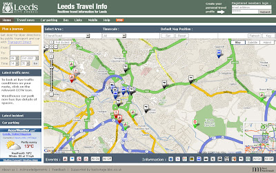
Real-Time Travel Information Map - Leeds

Real-Time Travel Information Map - Leeds

The Map shows the location of all traffic affecting Road Closures, Roadworks and Planned Events active now or in the near future.

Leeds Travel Information Map
An excellent 'mashup' using numerous data sources including BBC Backstage and Leeds City Council.

Tips on Use: If the map looks cluttered when you visit first use the content panel and switch off all then click individual icons for that layer to be displayed.
Also available is a set your last selected default map position and also remembers your last selection of travel information types and time.

Full Features of the Leeds Travel Information Map
  • Map: the map shows the locations of all traffic affected by road closures, roadworks and planned events that are active now or in the near future
  • Car Parking: A list of up to the minute information on car parking spaces
  • Travel News: This tab contains a searchable list of all traffic affecting road closures, roadworks and planned future events.
  • RSS Feeds: subscribing to the RSS feeds you can receive up to the minute travel information of your choice for the Leeds area
  • Mobile Services: live travel information to mobile phones with Google Maps for Mobile
More Information from the Help Guide
and for a Full Legend for the Map Icons go to the Key

Leeds Travel Information Map


More like this please! Mapperz

Labels: , , , , ,

19 January 2007

Travel Intelligence Maps

Travel Intelligence Maps

Nice Map Integration of the Mapsack

Features
  • Hover on linked text (side panel) to highlight Point of Interest (poi's)
  • Map display area is link with the photo rail at the bottom.
  • Nice and clean interface
  • Fast database retrieval of information (ajax?)

Travel Intelligence UK Map

More Maps like these please!

Labels: , , , ,

01 December 2006

TravBuddy Map

Make a TravBuddy Map

Mapperz TravBuddy MapMapgirl TravBuddy Map

Very easy to make - select the countries you have visited and the map is generated.
Code and paste the code into your web page.

Labels: , , ,

27 November 2006

Interactive Map - Oxford

Interactive Map of Oxford
Clean and simple interactive map with panaromic views of Oxford.

Source:World Travel Blog

Labels: , , ,

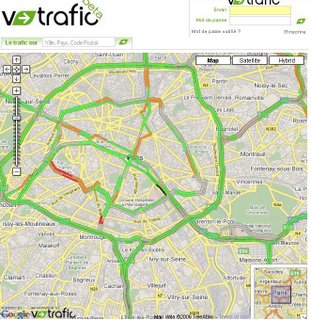
v-Trafic Beta - French Traffic Congestion Mapped

v-Trafic Beta - Traffic Congestion
Nice clear mapping overlay on a google map.
This shows in near real-time traffic congestion for the whole of France.

Labels: , , , , ,

14 November 2006

AA Travel Planner Updated

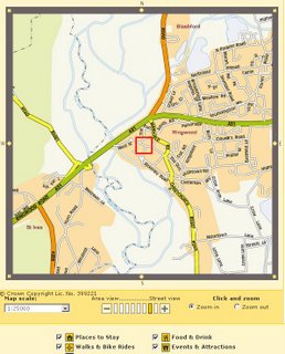
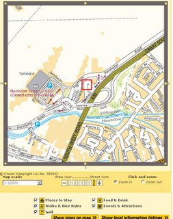
The AA Travel Planner has been updated. Points of Interest (POI) have been now included into the Travel Planner and the Street by Street Map Finder

New Features are:
Speed Cameras or Safety Cameras to be PC (Static Only) Plotted on your route.
Petrol Stations (though not all)
Traffic Blackspots
AA Travel Planner- Speed Cameras

Map Finder uses the AA Street by Street products in digital format
but with the added features
  • Postcode
  • Private Streets
  • Places of Interest
AA Travel Planner - Street By Street - MapVu DataAA Travel Planner - Street By Street - AA Data
Top MapVu speced to AA spec - Bottom AA Street by Street Digital

Labels: , , , ,