->

02 February 2011

Crime Maps England & Wales

Crime Maps England & Wales

Recorded crime in England and Wales on Google Maps - find what crimes have been committed in their neighbourhoods.

The map shows crime mapped to "an anonymous point on or near the road where they occurred." NOTE: Individual addresses are not pinpointed on the map.

To search for crime in an area users can enter a postcode or an address. The map will then display the crimes committed in a radius of the submitted location. The maps include a pretty neat marker clustering system and the number of crimes are also broken down by category.
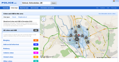
Crime Maps  England & Wales
Crime Maps for England and Wales - to Street Level - Search by postcode, town name or street.

Example:
http://www.police.uk/crime/?q=Oxford,%20Oxfordshire,%20UK#streets

Built on the API - http://www.police.uk/api/docs/

Source:
Google Maps Mania
http://googlemapsmania.blogspot.com/2011/01/uk-launches-national-crime-map.html

Interesting related post on the Guardian
http://www.guardian.co.uk/technology/2011/feb/02/uk-crime-maps-developers-unhappy

Labels: , , , ,

20 October 2009

Crime Maps (England & Wales ) Released

Crime Maps (England & Wales ) Released

Crime Maps (England & Wales ) Released
The long awaited crime maps have been released.

Crime Maps Guilford, Surrey (England & Wales ) Released
Bing Maps are used with Police boundaries that are thematically styled with crime rates.
centring the map with the 'gun' sight target pulls up information from the authority. Up to 5 authoritiies can be compared at once.

"The map was launched today by Home Office minister David Hanson and National Policing Improvement Agency (NPIA) deputy chief executive Steve Mortimore"

Quick Links
http://maps.police.uk/view/avon-somerset/
http://maps.police.uk/view/devon-cornwall/
http://maps.police.uk/view/dorset/
http://maps.police.uk/view/wiltshire/
http://maps.police.uk/view/hampshire/
http://maps.police.uk/view/surrey/
http://maps.police.uk/view/sussex/

related previous posts:
http://mapperz.blogspot.com/2009/08/bbc-crime-map-truth-about-crime.html
http://mapperz.blogspot.com/2008/08/london-metropolitan-police-crime.html

Source:
http://www.inthenews.co.uk/news//crime/government-launches-crime-maps-to-public-$1335231.htm

News links (they finally catch up)
http://uk.news.yahoo.com/5/20091020/tuk-online-maps-let-public-compare-crime-45dbed5_2.html
http://news.bbc.co.uk/1/hi/uk/8315089.stm
http://www.dailymail.co.uk/news/article-1221604/Crime-maps-allow-householders-check-areas-boon-burglars.html

Labels: , , , , , ,

05 June 2009

BBC Live Election Map (England & Wales) - June 2009

BBC Live Election Map (England & Wales) - June 2009

England & Wales Live Elections Map June 2009
Over the next day this map will change colours representing local elections results.
The Map is using live (confirmed and verified) data and is fully interactive based in flash.
Users can select their local county/authority and find more details on the results.

The Interactive Election Map (Flash required)
http://news.bbc.co.uk/1/shared/bsp/hi/elections/local_council/09/map/html/map.stm


Non-Map Link (A-Z Listing)
http://news.bbc.co.uk/1/shared/bsp/hi/elections/local_council/09/html/region_99999.stm

Labels: , , , , ,

20 August 2008

Free Maps for Education (in PDF format)

Free Maps for Education (in PDF format)

Maps International
have release free maps in A3 paper size
(297mm×420mm or 11.7''×16.5'')

Maps International Educational Free Maps - Europe
Politically coloured Europe map for Free

Maps International Educational Free Maps - World
This World Map is available for educational use at not cost.
(Politically coloured World map with hill shading and bathymetry.)

"Maps International Education shop provides education wall maps and geography teaching resources and aids for all ages. Our product range is extensive and includes the new exclusive Primary Schools wall maps. Also available to purchase are key geography texts for higher and further education including subjects such as Earth Sciences, Regional and Area Planning and many more Geography based subjects."

Other Free Maps available:
  • UK map with major transport links including motorways, primary routes, ferry routes and airports.
  • UK map with major transport links including motorways and airports.
  • UK map with parliamentary boundaries and names.
  • Wales map with country/ county/ district/ unitary boundaries and names
  • Scotland map with country/ county/ district/ unitary boundaries and names
  • England map with country/ county/ district/ unitary boundaries and names.
  • Europe map with hill shading and hypsometry.
  • Outline black and white World map with country borders, capitals and country names.
  • Outline black and white World map with country borders only.

These Maps in PDF format are available from
http://www.mapsinternational.co.uk/education_downloads.asp

TERMS OF USE
All material is copyrighted and should not be reproduced for commercial use. If you intend to use the free resources for anything other than classroom use, then contact Maps International on Free Phone 0800 038 6277 or sales@mapsinternational.co.uk to discuss the cost and royalties applicable. No responsibility can be assumed for the accuracy of the information given.

Labels: , , , , , , , , ,

16 May 2008

DEFRA Noise Maps (England)

DEFRA Noise Maps (England)

Noise Mapping Defra England Cities - Bristol
Defra Map of Bristol day time road noise levels.

Noise maps only cover cities, but cover day noise (Lden) and night time (Lnight) noise levels
4 Layers are available - Road, Rail, Industry and Air noise.

The Noise Mapping England site currently supports the following urban areas only:

Birkenhead
Blackpool
Bournemouth
Brighton
Bristol
Coventry
Hull
Leicester
Liverpool
London
Manchester
Nottingham
Portsmouth
Preston
Reading
Sheffield
Southampton
Southend
Teeside
The Potteries
Tyneside
West Midlands
West Yorkshire


"The noise maps have been produced by Defra to meet the requirements of the Environmental Noise (England) Regulations 2006, and are intended to inform the production of noise action plans for large urban areas, major transport sources, and significant industrial sites in England.
Directive 2002/49/EC - more commonly known as the Environmental Noise Directive (END) - concerns noise from road, rail and air traffic and from industry. It focuses on the impact of such noise on individuals, complementing existing EU legislation which sets standards for noise emissions from specific sources. The END requires:
the determination of exposure to environmental noise, through noise mapping;
provision of information on environmental noise and its effects on the public;
adoption of action plans, based upon noise mapping results, which should be designed to manage noise issues and effects, including noise reduction if necessary;
preservation by the member states of environmental noise quality where it is good."

The Interactive Maps can be found at:

http://noisemapping.defra.gov.uk/wps/portal/noise

Related News Sources:

http://news.bbc.co.uk/1/hi/uk/7403280.stm

http://www.telegraph.co.uk/news/1967803/Noise-pollution-map-warns-of-health-risks.html

Blog

http://bridgetfox.wordpress.com/2008/05/16/noise-mapping/

Labels: , , , , , ,

10 September 2007

National Intrusion Map England

National Intrusion Map for England

National Intrusion Map - England
Source: CPRE
The Campaign to Protect Rural England (CPRE) has releases New Maps depicting the Intrusion of many sources (traffic, rail, air, dense population, power lines etc) that lead us to a more intrusive way of life.
  • Within 3km
- of very high disturbance roads such as most major motorways and A roads (e.g. M25, M1, M6) with over 75000 daily traffic flow
- of the edge of large towns of over 270,000 people (e.g. size of Southampton, Liverpool)
- of power stations;
  • Within 2km
- of sections of some motorways (e.g. M6 north of Preston) and many urban A roads with 25,000 to 75,000 daily traffic flow (e.g. A184 in Durham or A24 in West Sussex);
- of the edge of smaller towns of 4,000 to 270,000 people;
  • Within 1km
- of many urban A roads (e.g. within London or Birmingham) and some rural A roads with 10,000 to 25,000 daily traffic flow or ;
- of the published noise contour (57 decibels equivalent sound figure) for civil airports;1
Within 0.5km
- of many rural A roads with 5,000 to 10,000 daily traffic flow (e.g. A594 between Ambleside and Keswick in the Lake District or A354 from Salisbury to Dorchester);
- of settlements of 2,500 to 4,000 people;
- of mainline railways;
- of 400KV and 275KV power lines

Source: CPRE

Where are the Maps?
Developing an Intrusion Map of England (PDF)

Intrusion Map Explained
(PDF)

Large Map (PDF)

Where are the least intrusive places?

"The largest remaining areas of unspoilt countryside are mostly in the national parks - Dartmoor, Exmoor, the Yorkshire Dales, the North Yorkshire Moors, the Lake District and Northumberland.

Shropshire and the North Pennines are also largely free from noise and eyesores."
Daily Mail

Labels: , , , , , , ,

05 February 2007

England Rocks! Map

Music Venues, Artist Locations, Gig Venues it all Rocks!

Click for the Map


England Rocks Map

Source:
Enjoy England

Top Tip - Click the Juke box page to see more Artists.

Labels: , , , , ,

27 November 2006

Interactive Map - Oxford

Interactive Map of Oxford
Clean and simple interactive map with panaromic views of Oxford.

Source:World Travel Blog

Labels: , , ,