->

22 July 2011

Met Office - Storm Tracker Beta

Met Office - Storm Tracker Beta

Met Office Storm Tracker

The Met Office has created a new Google Maps Flash Map to monitor and forecast tropical storms around the world.

There are two versions of this map - Free and Premium (Paid For)

Free Version
· 1 x forecast weather layer (UK deterministic 5 day storm track)
· 1 x observed track
· 3 x latest weather layers:
· cloud (IR and Visible satellite)
· sea surface temperatures
· Thousands of historic storms (HURDAT data from 1850 until the present).

Advanced version (paid for service)
Additional premium content for an advanced service is available at a subscription rate.
The advanced service includes access to all the above, plus:
· Probabilistic forecasts of storms and weather – so a range of possible scenarios
can be understood
· Met Office 15 day ensemble forecast storm tracks; and equivalent data from
European Centre for Medium-range Weather Forecasting (ECMWF) and USA’s
National Oceanic and Atmospheric Administration (NOAA).
· Multi-model combinations of these leading models

· Additional forecasts for storms, including strike probabilities, forming storms, and
ensemble mean storm tracks
· A utilities layer showing district boundaries for the Gulf of Mexico
Access to these features enables users to build a far more complete picture

Users require to have an account (even for the free version) worldwide cloud conditions and the locations of current cyclones. If you select a cyclone on the map you can view the cyclone's observed track and wind speeds recorded along the track.

As well as viewing current tropical storm conditions it is also possible to view historical storm information. For example you can view the track of the 2009 Hurricane Bill.


Met Office Storm Tracker Historic Tracks


Storm Tracker Worldwide Map by the UK Met Office.
http://www.metoffice.gov.uk/premium/stormtracker/
(sign up and login required to view both free and premium)

Source:
http://googlemapsmania.blogspot.com/2011/07/worldwide-tropical-storm-tracker.html

Labels: , , , , , ,

24 February 2011

Embed ArcGIS Online Maps for Free

Embed ArcGIS Online Maps for Free


View Larger Map

required > OpenStreetMap and the license (CC-by-SA). < http://wiki.openstreetmap.org/wiki/OpenStreetMap_License#Attribution">OSM attribution).

A fix is required on the ESRI side [code]

Thanks to David highlighting the issue.
http://lists.openstreetmap.org/pipermail/talk/2011-February/056894.html

Full Screen Map
http://www.arcgis.com/home/webmap/embedViewer.html?webmap=1907d8d1c2954484b4b6569b5d8de305&zoom=true&scale=true


ArcGIS Online Example & Make your Own Map(s)
http://www.arcgis.com/home/
source:
http://nygeog.blogspot.com/2011/02/embedding-arcgis-online-maps-open.html
deleted by poster.

Labels: , , , ,

20 July 2010

StepMap - Create Free World Maps

StepMap - Create Free Personal World Maps

"StepMap is a free service, enabling you to create, edit and share individual and personalized maps. Also, it allows you to export your maps to any other web site. The term "map" includes all kinds of topics, themes and design option. StepMap offers you a free tool to create maps that represent your specific, personal requirements and design ideas."

Step Maps - Create Free World Maps - Step1
Create and customise your own world, regional or country map with this service.

Step Maps - Create Free World Maps - Step2
Change the style, add, symbols, images, media, text, metadata a comprehensive resource in creating very specific mapping for personal and commercial use.

Personal Commercial
Creating a Map using the Online-Editor FREE FREE
Presentation in the Map Directory FREE FREE
Save as private Map FREE FREE
Embedding the Map to another website FREE FREE
Additional web space for rich media FREE FREE
Adding to Google Search FREE FREE
Printing a Map FREE PAID


StepMap for Educational Purposes

The free of charge features that are listed for private users also apply for any educational purpose, e.g. schools, universities or research.

That means that teachers and students can use StepMap for free considering the general terms ad conditions.

http://www.stepmap.com/termsofuse2.php


Try creating your map

An example

Labels: , , , , ,

21 April 2010

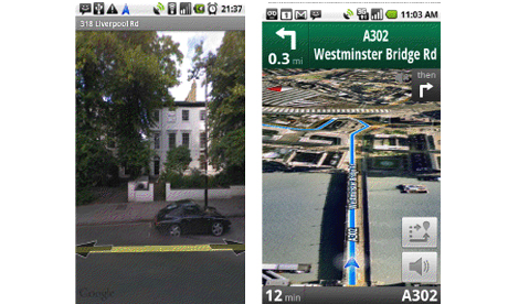
Google's FREE Navigation killer - now released for the UK

Google's FREE Navigation killer - now released for the UK ( & Ireland)

Google's FREE Navigation Killer
Image:The Guardian

http://www.google.com/mobile/navigation/

Killer Features:

  1. FREE
  2. Voice Commands
  3. Traffic Indicator (Red Slow/Stop, Yellow, Green Go.)
  4. Map, Satellite and Streetview modes
  5. There are already upwards of 50 million people using Google Maps.

Full Article by Jemma Kiss
http://www.guardian.co.uk/media/pda/2010/apr/21/digital-media-google

Download Google Maps Navigation
http://www.google.com/mobile/navigation/

Labels: , , , ,

21 January 2010

Big News - Nokia Ovi Maps Free for Life

Big News - Nokia Ovi Maps Free for Life

updated 5.07pm 21/01/2010
Nokia Ovi Maps Free for Life
No more subscriptions, Ovi Maps with Navigation (Walking, Driving) is now Free.
*N97 soon after firmware update release.
update N97 users: "New Ovi Maps for N97 will be available on 28th January 2010." with Maps v3.3 included in the firmware update.

note:some N97 users are confirming that the new ovi maps application will install when there is more than 20mb free space on the c: drive (untested by mapperz).

A New version of Ovi Maps 3.3 comes with FREE driving (car) & walking (pedestrian) features turn-by-turn, with voice guided navigation. Ovi Maps has a large global coverage.
74 countries are covered.
Maps Data for all the regions will be available, for free, for loading over the air (data costs!) or pre-loading via a desktop computer (PC or Mac). Traffic information and city guides from the likes of Lonely Planet and Michelin, will also be made available at no additional cost.

Since Nokia owns Navteq (the map data company) they can do this without losing out. So Google, tomtom and many others look out.

Press Release:January 21, 2010
Nokia makes walk and drive navigation free on its smartphones, doubling size of mobile navigation market
http://www.nokia.com/press/press-releases/showpressrelease?newsid=1375569

Video


Official Nokia Maps Website
http://maps.nokia.com/explore-services/ovi-maps/ovi-maps-main

Supported Devices for the Nokia Ovi Maps v3.3
http://europe.nokia.com/support/product-support/maps-support/compatibility-and-download#/default/

More Details at:
http://www.womworld.com/nokia/13158/your-thoughts-on-this-mornings-ovi-maps-announcement/
http://www.allaboutsymbian.com/news/item/11010_Nokias_Ovi_Maps_navigation_goe.php

News Links
PC World
http://www.pcworld.com/article/187335/nokia_delivers_free_navigation_service_to_customers.html

Engadget
http://www.engadget.com/2010/01/21/nokia-ovi-maps-with-free-turn-by-turn-navigation-hands-on/

BBC News
http://news.bbc.co.uk/1/hi/technology/8472165.stm

The Guardian
http://www.guardian.co.uk/technology/2010/jan/21/nokia-satnav-software

The Times Online
http://technology.timesonline.co.uk/tol/news/tech_and_web/article6996954.ece

Labels: , , , , , , ,

16 November 2009

Free Wall Maps to Print - Geography Awareness Week

Free Wall Maps to Print - Geography Awareness Week

National Geographic sponsors & highlights:

Geography Awareness Week 2009, with its theme of "Get Lost in Mapping: Find Your Place in the World" was kicked off on Sunday 15th November 2009.


"The Geography Awareness Week Web site offers students, teachers and the public access to games, activities and lessons about mapping. The site features contributions from National Geographic and partner organizations such as Google and ESRI. Visitors can learn about mapping at home and at school, as well as experiencing geospatial technologies and learning how to become "map activists." Visitors can explore maps of all sizes, from high-tech to low-tech, and can download a free poster-size National Geographic world map for the bedroom or living room wall. Google Earth tours offer virtual interactions with fascinating people and places, and engaging videos explain how today's geospatial revolution is changing everything from shipping to warfare."


Free Wall Maps to Print
http://mywonderfulworld.org/pdf/mww_worldpol.pdf

[pdf that can be printed in 6 sections]

More Free Wall Maps to Print
There are more wall maps across the world Physical/Political /Terrain to download and print out are available here:
http://java.nationalgeographic.com/studentatlas/printpdf.html?

source:
http://www.directionsmag.com/press.releases/index.php?duty=Show&id=39752

Labels: , , , , , ,

31 July 2009

Free Ordnance Survey Maps for the iPhone

Free Ordnance Survey Maps for the iPhone

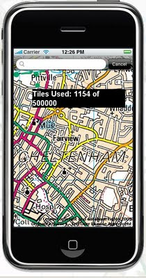
iOSMaps v1.0 has launched.
"Get the OpenSpace Ordnance Survey© mapping application for the iPod Touch© and iPhone© from the iTunes© Store for FREE right now!"

"The application is intended to be free, making use of newish technologies to showcase the awesome possibilities/fun of marrying different technologies. I see iOSMaps being used in replacement of paper Ordnance Survey maps. For what every your outdoor pursuit, be it mountaineering, skiing, fell running, hiking, cycling or a good old fashioned walk, just enjoy using the application on your iPhone"
Author of this application

What is looks like on screen? (minus the tile number)

Free OS Maps iPhone
This service is not the fastest, but does work well, though you will find high data transfers costs using this service. But the idea is right, if caching of data is allowed on the phone in theory the user can 'cache os maps' before they venture out with the device.

iOSMap uses the new the mapping data provided by the OpenSpace API from Ordnance Survey, to show feature rich geographic, geotopic and cartalogic data of Great Britain. The application make use of OpenLayers, gmaps and prototype libraries and was written using the mighty iPhone sdk in Objective-C 2.0 and C.

Geeky info:
client:
iPhone/iPod Touch.

OpenLayers:Map,Control,GridProjection
OpenSpace 0.72:Map, Gazetter, GridProjection
Prototype1.6:prototype.js, scriptalicios.js
Google:gMapsAjaxSearch, googlemaps (check terms of use using google maps api and openspace api together?)

But very promising and will be the future of mapping, though not sure it will replace paper/book maps as they never run out of batteries...
Mapperz

To get the free OS Maps App on the iPhone website is:
http://www.publicfootpaths.com/

Labels: , , , , , , ,

07 April 2009

OpenJump GIS

OpenJump GIS [Free Java based GIS]

update 21/04/2009

OpenJump 1.3 (more GIS analysis, faster, better)

http://www.openjump.org/wiki/show/New+OpenJUMP+Release
source: SlashGeo

There are more and more Open Source Projects coming along though which is the better of the bunch?
Not saying this is the 'best' though users are different to the developers.
OpenJump GIS is one of the better all round 'Free GIS' programs because:
  1. It supports common GIS formats (.shp, .tif, .gml etc).
  2. You can EDIT the data - lots are free but this one you can fully edit the data.
  3. You can do some GIS Analysis!
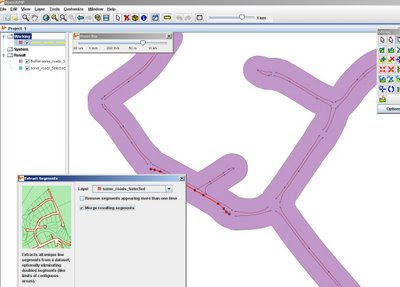
OpenJumpGIS - Buffering
Buffering for Free, OpenJump does do plenty of spatial analysis.

Spatial Analysis built-in (no plugins required!)
  • Intersect, Buffer, Union, Symmetrical Differences, Centroid
  • Generalisation
  • Polygonise (converts lines to polygons)
  • Join attributes by spatial location
  • Thiessen Polygon Creation
  • Attribution Queries
Additonal 'Plug-ins' can be loaded - though it's best the download them separately and unzip them on you computer the folder.

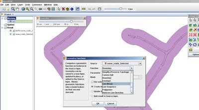
OpenJumpGIS - Geometry Functions
More Geometry Functions: Line Merge

More information on Open Jump

http://openjump.org/wiki/show/OpenJUMP


Future Suggestions? - More of the same, this is great for students and non-commercial, non profit organisations with limited budgets.
Maybe a Print View/Layout function if need to print
Support for (.osm and .gpx for OpenStreetMap) would be very helpful to many 'map makers'

OpenJump can also export to common formats (.gml, .wkt, .shp and postgis tables)

via SlashGeo
We mentioned other open source GIS software such as Quantum GIS, GRASS GIS, uDig and gvSIG amongst others.

Labels: , , , , , ,

03 November 2008

SatSki [Free Maps Coming Soon]

SatSki [Free Maps Coming Soon]

SatSki is making it's maps available for free for smartphones

"Satski is a touch screen colour GPS system which uses ‘real time’ while on the piste to plot user’s routes and guide skiers and boarders of all different levels around the resort, providing an easy to use, interactive piste map."


SatSki on SmartPhoneSatSki Google Earth Demo
[images sources: SatSki]

"As of 6th November Satski will provide FREE ski map downloads for smart phones. The Satski free downloads offers basic features such as piste/trial map and resort specific information"

Emergency Feature:
This feature provides crucial information for those in need of help and assistance from rescue services at the press of a tab the Satski software will allow the user in an
emergency situation to send their exact location coordinates to Mountain rescue/ Piste security (Longitude and Latitude) as well as their mobile phone number.
[if have a mobile/cell network]

source:http://www.satski.com/News.aspx

Labels: , , , , ,

17 October 2008

Embed Multimap Maps - New

Embed Multimap Maps - New

Multimap have announced via the Microsoft LiveSide that it is now possible to embed Multimaps in your own websites and blogs.


View map of Greater London on Multimap.com
Birds Eye view of Greater London on Multimap.com
Get directions to or from Greater London on Multimap.com

The above map is the new service of embedding multimap maps.

What is New?
  • We [Multimap] launched a new service for small businesses, personal websites and hobbyists this week.
  • The service, available for free from Multimap.com, provides a single line of HTML to cut and paste into a web page.
  • The user gets a slippy map in a choice of map styles (TeleAtlas, Ordnance Survey and Barts) or aerial for anywhere in the world (US included, using VE maps and aerial).
  • The pasted HTML includes four hyperlinks back to Multimap.com:
    1. See this location on Multimap (for a bigger map, POI, business listings, etc)
    2. See this location in Birds Eye
    3. Get directions to this location
    4. Get directions from this location
  • The service is limited to 50,000 transactions per year (which we track) and cannot be used for internal apps (eg BI, CRM)
1. 50,000 transactions a year is not very many, would be better if this was a week or a day.
2. 4 hyperlinks seems to be overkill... 1 or 2 would look better.


Can you embed Multimaps maps? Yes but Multimaps FAQ has yet to be updated.

"No. Licensing restrictions imposed by our data suppliers mean that users are not permitted to display the maps within their own website - even if the user is linking to our website behind the image. However, maps without our advertising or branding are available for a fee. Please see our Business Services section for more information on our mapping options."
http://www.multimap.com/help/#aq64

Source:
http://www.liveside.net/main/archive/2008/10/16/virtual-earth-get-a-multimap-map-on-your-site-for-free.aspx

Don't want to embed the Multimap have a tiny url creator - for the map above
http://www.multimap.com/s/Ap27JczF

Labels: , , , , , ,

20 August 2008

Free Maps for Education (in PDF format)

Free Maps for Education (in PDF format)

Maps International
have release free maps in A3 paper size
(297mm×420mm or 11.7''×16.5'')

Maps International Educational Free Maps - Europe
Politically coloured Europe map for Free

Maps International Educational Free Maps - World
This World Map is available for educational use at not cost.
(Politically coloured World map with hill shading and bathymetry.)

"Maps International Education shop provides education wall maps and geography teaching resources and aids for all ages. Our product range is extensive and includes the new exclusive Primary Schools wall maps. Also available to purchase are key geography texts for higher and further education including subjects such as Earth Sciences, Regional and Area Planning and many more Geography based subjects."

Other Free Maps available:
  • UK map with major transport links including motorways, primary routes, ferry routes and airports.
  • UK map with major transport links including motorways and airports.
  • UK map with parliamentary boundaries and names.
  • Wales map with country/ county/ district/ unitary boundaries and names
  • Scotland map with country/ county/ district/ unitary boundaries and names
  • England map with country/ county/ district/ unitary boundaries and names.
  • Europe map with hill shading and hypsometry.
  • Outline black and white World map with country borders, capitals and country names.
  • Outline black and white World map with country borders only.

These Maps in PDF format are available from
http://www.mapsinternational.co.uk/education_downloads.asp

TERMS OF USE
All material is copyrighted and should not be reproduced for commercial use. If you intend to use the free resources for anything other than classroom use, then contact Maps International on Free Phone 0800 038 6277 or sales@mapsinternational.co.uk to discuss the cost and royalties applicable. No responsibility can be assumed for the accuracy of the information given.

Labels: , , , , , , , , ,

05 September 2007

N95 Free Mobile Software (including Maps)

New N95 Free Mobile Software (including Maps)

reLive! Map London Demo

Nokia Download!
New
"Download! for PC enables you to discover mobile content using a PC. When you connect your mobile device to the PC, Download! for PC automatically synchronises with the corresponding software on your device. This makes it easy for you to find, download and manage content (maps) that is compatible with your device."
http://www.nokia.com/betalabs

Opera Mini 4 Beta v2
http://www.operamini.com/beta/
A Good Mobile Browser that allows you to view web based mapping now in landscape mode.

amAze 4.0
http://www.amazegps.com/index.php?page=countries&language=uk
The best Free Sat Nav For GPS enabled phones (includes N95)

Mosh Nokia New!
http://mosh.nokia.com/
"Your Stuff. Any Phone. Everywhere."
A good resource for finding and sharing Apps, Software,Music, Maps, Games, Pictures, Ringtones etc.

Local Search (Yell and Yahoo Search integrated with Map Option with results)
http://mobilesearch.nokia.com/A4160040


Mapperz Top Pick
reLive!
a unique and handy leisure application, allows you to take photos and write notes along your trip route, and seamlessly attach them to their locations on the map (geo-tagging).

reLive! Map

Demo ( in Flash)
http://relive.atlasct.com/map.asp
Download reLive! at
http://relive.atlasct.com/wap/ (via your mobile)

more info at
http://www.atlasct.com/Applications-ReLive.html

Labels: , , , , , , ,

16 June 2007

New Faster Maploader - Nokia

New Faster Maploader - Nokia

New Maploader v1.1

Faster MapLoader 1.1 downloading map data has improved vastly :)

New Maploader Voices

Now comes with voice commands in 24 Languages.
English (UK) has 0.2mb more the English(USA).

Nokia Maploader v1.1 New Data UK

Checked UK differences in Data from the last upload.

England has more data was 90.3mb now 95.8mb (6% increase in detailed coverage)
Northern Ireland has more data was 6.6mb now 6.7mb (1.5%)
Wales has much more data was 12.7mb now 16.7mb (24% increase)
Scotland 18.4mb now 19.4 (6% increase)

New Maploader Speed is much better
England at 95.8mb was downloaded in less that 8 minutes, the software then transfers to the memory card and verifies the map data has been completed successfully.
Voice for English [UK] took 45 seconds to download and a minute to transfer and verify.

Smart2Go update coming very soon.
More on this over at
http://www.allaboutsymbian.com/

Tips- 1. BACKUP YOUR PHONE - VERY IMPORTANT! - Use Nokia PC Suite Backup to your PC and the backup function on your phone - backup phone to memory card.

2. FLASH YOUR FIRMWARE, v11.0.026..... is the latest *#0000# will show your version on screen on your phone.

Go get Maploader v1.1
and enjoy free digital maps on your phone.

Mapperz

Free Maps, Nokia,N-series,N95, Maploader,

Labels: , , , , , , ,

09 April 2007

N95 Free Applications - including GPS & Maps

N95 Free Applications - including GPS & Maps

N95 in the Box
Source: Mapperz (this blog (via adsense) helped buy this device!))

To Start an Official Application (Supports Google Earth Output- KML)

Sports Tracker
"If you own a N95 one of the first things you should do is download the recently released free application 'Sports Tracker' from Nokia. Sports Tracker is aimed at the sports or general user on foot or cycling and more importantly it provides full route tracking with the ability to upload to Google Earth."
Source and More Info at Digital Urban

MapLoader and the Standard Software on the PC>Phone does the Job.
(though have a day to hand loading the maps on - 150mb took 6 hours)

Though recommend you only use this for Foot and Car Naviagation in Semi-Urban and Urban Areas. Or if you do hill walking, hiking and mountaineering this software is not for you.
The solution here would be to be able to import your own maps.

update:more free official apps here

Mobile GMaps
"Mobile GMaps is a FREE application that displays Google Maps, Yahoo! Maps, Windows Live Local (MSN Virtual Earth) and Ask.com Maps and satellite imagery on Java J2ME-enabled mobile phones, PDAs and other devices. MGMaps can connect to a GPS receiver over bluetooth or use internal GPS features on some phones in order to automatically display the map for your current position."
More Info and Download at mgmaps


Online Data Backup
All this Data but what if the phone goes down and and out have not backed up your phone?
"Store your mobiles phone numbers, calendar and SMS safely with ZYB. Sign up now, and get a copy of your precious mobile content"
https://zyb.com/

A Very Fast Calculator
Try this simple example: start the standard calculator and do 2/3 x 7. It takes 13 clicks. Using Calcium it only takes 6!
More Info
http://mtvoid.com/calcium/

Like to Stay in Contact?
Via Wifi or EGPRS*

http://mobile.live.com/wml/

http://mobile.yahoo.com/go


http://code.google.com/p/mobile-google-talk-http/

or use this app for all three
http://www.gizmoproject.com/
(Yahoo! Messenger, Google Talk, or Windows Live)

Free Phone Calls? (using Voice Over IP)
Using Wifi or EGPRS*
Fring

EGPRS* is charge by data transfer - depending on your network operator and mobile tariff this can vary in cost. Use Wifi if you can!
http://en.wikipedia.org/wiki/Enhanced_Data_Rates_for_GSM_Evolution
_Rates_for_GSM_Evolution

add a comment if you know of more!

mapperz

additions pending.... mapperz approval


Labels: , , , , , , ,

26 February 2007

Free Subway Maps Across the World

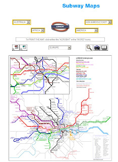
Amadeus Global Travel Distribution is allowing people to view and download subway/underground/tube maps for free.

Free Subway Maps - London

There are many locations across the world to many too list

here are a handful, available in PDF and Word formats
and many, many more.

Source:LifeHacker via Google News

Mapperz

Labels: , , , , ,

01 February 2007

UK Geocoder Maps - Postcode and Street Addresses

Mapperz has requests after requests on UK Geocoding Postcodes and Addresses for the UK.

Using Google Maps API and Local Search Two Geocoders have been created

Please use the Official Method.
http://gmaps-samples.googlecode.com/svn/trunk/geocoder/singlegeocode.html

Local Search Example
http://geo.localsearchmaps.com
http://geo.localsearchmaps.com/?street=48+Leicester+Square&
city=London&country=UK
returns
map.centerAndZoom(new GPoint(-0.130427, 51.510036), 4);

Mapperz just returns the GPoint on a Google Map and displays the center of the map

Top Tip: is you can zoom in after the result is returned to display your Postcode or Address locations.

Note: This is only using data freely available on the Internet.

Other Geocoders are available

US Geocoder

Yahoo

InfoSports
Manual Geocoder

Batch Geocoder

Related:
ASK City Supports Reverse Geocoding

Simple Geocoding using Google Maps

3D Geocoding (Microsoft Live Local)


Geocoding Via Google AJAX Searches

Labels: , , , , ,

amAze - Free GPS Navigation Software for Your Mobile Phone

amAze - Free GPS Navigation Software for Your Mobile Phone

"amAze is a first of its kind mobile local search and navigation application, and it's totally free!"

amAze - Free GPS Navigation Software

Features and features coming soon:
  • Visual and voice guidance to any destination
  • Search or define any location by its address
  • Search and navigate to businesses listed in yellow pages directories (where available)
  • Present any required location on the map
  • View and use dynamic high quality maps at various scales
  • View aerial photos and satellite images(soon!)
  • View topographic maps(soon!)
  • View real-time traffic conditions on the map(where available)
  • Calculate the fastest way between two locations
  • Save and manage personal favourites list
Map Coverage

Supported Phones and Bluetooth GPS (required)

Quick Guide (PDF)

amAze was created by LocatioNet Systems Ltd.

*Note: Integrated GPS phones are not yet supported
Mapperz would like to see this supported very soon for the Nokia N95 which is to be released 7th March 2007 in the UK

Labels: , , , , , ,

17 January 2007

Powerful Mapping Applications

Using Google Maps API and Oracle Application Express (APEX)
Google Maps and Oracle Apex
Source and image: inside-apex this blog has lots more information and links to build your own powerful mapping application.

Mapperz

Labels: , , ,

18 December 2006

Free Simple UK Geocoding Searches - via Google

Mapperz is asked a lot about UK Geocoding and Address Geocoding.

The Google Maps API will Geocode Addresses but due to "Contractual Reasons" they are not allowed to provide it for the United Kingdom. But Google does have this information available to you and yes you can retrieve it with simple google searches via Google Maps.

Here is a very basic request
using Google Maps (UK Version)

An address Search term

"10 Downing Street, London"

Gives you this result

UK Geocoding via Google Maps
Click "Link to this Page" will give you a long url


http://maps.google.co.uk/maps?f=q&hl=en&q=10+Downing+Street,+London
&sll=53.098145,-2.443696&sspn=6.97008,17.512207&ie=UTF8&amp;;z=16
&ll=51.503253,-0.127544&spn=0.007052,0.02414&om=1&iwloc=addr


ignore the first Latitude and Longitude and take the second pair.

you can also add zoom levels

http://maps.google.co.uk/maps?&z=17&ll=51.503253,-0.127544
will zoom in to street level.

This can be also exported to a kml and be viewed in Google Earth.
http://maps.google.co.uk/maps?&z=17&ll=51.503253,-0.127544&output=kml

This will create a .kml and ask you to open it or save it.
If you save it - this can be renamed .xml for use in other applications etc.


If your a programmer you can batch this up to make an address database free of charge.


For Real Programmers this looks to be an excellent source for on the fly geocoding

geopy includes geocoder classes for MediaWiki (with the GIS extension), Semantic MediaWiki, the Google geocoder, the Yahoo! geocoder, geocoder.us, Virtual Earth, and GeoNames.

Labels: , , , , ,

11 December 2006

ClustrMaps - Map Your Site Visitors

Map your visitors to your website

ClustrMaps Beta


No hidden extras: For light users (under 2500 visitors daily) the service is free, forever.

The geolocation hit counter that is simple and powerful:
  • ClustrMaps: free, for light users (up to 2,500 visitors daily), limited archive of old maps
  • ClustrMaps+ : small monthly fee, unlimited archive of old maps, zoom to continents
  • ClustrMaps Pro: larger daily visit limit, embed zoomed maps in your own site's look and feel (you keep logs, we provide maps).

ClustrMaps is the only hit counter that accurately shows you the locations of all visitors to your site on a thumbnail map embedded in your page.

The basic service, 'ClustrMaps', is free, and does exactly what it says below: it is not just a 'trial', and there is no 'time limit'.

Labels: , , ,