->

12 August 2010

Sports Tracker 3.5 Released
Sports Tracker 3.5 Released

Sports Tracker
The Award winning FREE Sports Tracker Application gets an update along with revamped web service for viewing and sharing your routes.

"The newly launched online service allows users to store, visualize and analyze their workouts with enhanced tools, as well as share their media enhanced workout experiences with other Sports Tracker users - and the whole world. The online service also allows existing Nokia Sports Tracker Beta users to import their workout history to the new service.

The Sports Tracker mobile application has also been updated to support uploading of tracked data to the new service and direct sharing to Facebook. The update also extends the list of compatible devices to cover more than 50 device models."

Testing the New Sports Tracker:
Sports Tracker 3.50 Mapping GPS Routes
Mapperz has tested this and the services along with the phone application works seamlessly together.

With the FREE Sports Tracker application mobile phone becomes a full-featured GPS sports computer, keeping track of everything from calories burned while running to your average cycling speed over altitude. You get maps, time and distance calculators, step count, and even heart rate when you use a compatible Polar HR belt. You can chart your progress, find your strengths and weaknesses, and share with others.

The new mobile application allows users to:
  • Record activities with all the data needed to analyze the performance, including distance, speed, duration, route, step count and more.
  • Check their location on the map while running, cycling, walking or with any other outdoor activity, using Open Street Map as a map based (can be cached for offline use)
  • Upload their activity data from their phone to the Sports Tracker service
  • Share their activities and automatically geo-tagged photos with other users and friends on Facebook, directly from their phone
  • Optional with Heart Monitor - Record heart rate data by connecting the Polar WearLink®+ transmitter with Bluetooth® heart rate belt by Polar (€70 or $90USD)
  • Automatically compare speed, distance and duration of recorded activities


Get it here:
http://www.sports-tracker.com/

With this Launch Ovi (Nokia) are having a competition:


GPS Trace from Skating
Create your own shape and enter for a prize. Image: Ovi Blog

"What we’re asking you to do is simply this: make a funny or interesting shape with your Sports Tracker workout, share it publicly in the service and send a link of the shared workout to us."
For more information on this competition and what can be won go here:
http://blog.ovi.com/2010/08/12/sports-tracker-ovi-competition-launches-now

Labels: , , , , , ,

28 May 2010

Spacebits.eu Launch Map

Spacebits.eu Launch Map (Live Tracking on 30th May 2010)

Spacebits1 live tracking map
The Launch and Tracking Dashboard.
This will be the Live Dashboard for the official launch of Spacebits 1 which is scheduled for the 30th of May, 2010, 11AM UTC/GMT+1.

Time of launch on other cities in the world.

  • 03:00AM Los Angeles USA
  • 06:00AM New York USA
  • 07:00PM Tokyo, Japan
The Project
"The goal for this project is to launch an High Altitude Balloon (HAB) with a computer probe to near space in Portugal. The Helium filled Balloon will go as high as 30.000 meters (that's about 100.000 feet), to the stratosphere, then explodes and the probe falls with a parachute and is recovered on earth."

Location of Launch
Scheduled for launching the Balloon on 30th of May, 2010 at Castro Verde, Portugal.


Ver mapa más grande

For much more information on the Project please visit http://spacebits.eu/

The Live Map will be here http://spacebits.eu/live (a demo mode is currently available).

Setup - http://spacebits.eu/page/spacebits1live.html

Good Luck to the Spacebits1 launch. follow on http://twitter.com/flyspacebits

Labels: , , , , , ,

08 January 2010

Ovi Maps Racing - Sneak Peak

What happens when you combine Ovi Maps and Ovi Games? Ovi Maps Racing is what happens – another gaming title announced today by Nokia, coming soon to the Ovi Store.

Ovi Maps Racing


"In a truly unique experience, you use the GPS in your device to find your location or use Ovi Maps to choose any location in the world), then customize a track around your neighborhood, and finally fire up those engines."


useful? or just fun... you decide.

Labels: , , , , , ,

27 November 2009

Golfshot.com - World Golf Courses Mapped and App'ed

Golfshot.com - World Golf Courses

Golfshot Touchpoint

Golfshot is now available for the iPhone and available from the App Store.

  • Golfshot makes it easy
  • Over 22,000 courses ready to play
  • No software to install on your computers
  • Show up and golf

Golf is a game. It should be fun.

We designed Golfshot to be easy to use, understand and share.
No computer downloads...simply add Golfshot to your iPhone and go play golf.
Scorecards, Statistics and now GPS Aerial View and GPS List View, are all included with
Golfshot: Golf GPS.

Example Golf Course
Golfshot Map Preview
http://golfshot.com/Courses/Detail/12681/Shanklin-Sandown-Golf-Club

but many more from (23,000+)
http://golfshot.com/Courses

and On the iPhone
Golfshot

Distances calculated and touch screen controls for the golfer.

We have over 23,000 courses mapped – mostly in the US, but we’re adding them worldwide. You can search and view courses at golfshot.com/courses. You can also request new courses for free from the same page.


Golfshot: Golf GPS is now featured in the Apple App Store at introductory pricing and no subscription.
More details:
http://golfshot.com/Home/Easy

Full Users Guide
http://resources.golfshot.com/userguide.pdf

*Google [Aerial images and API] requires an internet connection to view images for the course.
Tip - You are able to download images with WiFi and they will be available on the course if you keep the app open.

Labels: , , , , , ,

15 October 2009

Atlanta Mapathon - Creating the Best Mapped City

Atlanta, the capital of the US state of Georgia will soon be the world's most digitally mapped city, according to organisers of a massive "Mapathon".
Source: BBC News

OSM Map Altanta Mapathon

http://www.openstreetmap.org/index.html?lat=33.792&lon=-84.336&zoom=10

What is a Mapathon?
Mapping on-mass [crowdsourcing] the downtown Atlanta area including parks, university campuses and historic sites. Volunteers will be on hand to help new mappers learn how to use a GPS or Walking-Papers and have helpful tips for beginners. Come for the whole day or just stop by for an hour to learn the basics of community mapping and add a few points of interest to the map.

Atlanta Citywide Mapathon

October 16th 17th 18th

During this three day mapping event, local businesses, community groups and OSM members will join together to launch a citywide initiative to help make the map of Atlanta one of the best in the US. For details of how to get involved in this fun, family-friendly event, see the Atlanta Citywide Mapathon page.

Useful links:
http://wiki.openstreetmap.org/wiki/Atlanta_Citywide_Mapathon
http://wiki.openstreetmap.org/wiki/Atlanta#Atlanta_Citywide_Mapathon

New to OpenStreetMapping?
http://wiki.openstreetmap.org/wiki/Beginners%27_Guide

Labels: , , , , , , , ,

22 June 2009

iPhone MobileNavigator [NAVIGON]

iPhone MobileNavigator [NAVIGON]

Navigon iPhone GPS Navigator
Now Available via iTunes Apps

"Turn your iPhone into a first-rate navigation system with MobileNavigator. Try the feature for yourself and enjoy the excellent user control and superior design that allow simple and intuitive operating. The application includes the latest map material from the market leader NAVTEQ and can be used without an Internet connection, which is of enormous benefit abroad, for example, as no extra charges are incurred. With MobileNavigator you can turn your iPhone into an equally handy and convenient route guidance system."

Features and range of functions:

  • 2D and 3D map displays
  • Can be used in portrait and landscape format
  • Precise voice announcements
  • Intelligent address entry
  • Reality View Pro (realistic display of motorway interchanges and exits)
  • Lane Assistant Pro
  • Real signpost display
  • Speed Assistant with adjustable audio-visual warning
  • Day and night mode for map display
  • Direct access and navigation to contacts saved in the iPhone's address book
  • The latest NAVTEQ map material including more than two million (EU version) places of interest (POIs)
  • Navigation is automatically resumed after an incoming phone call
  • Quick access to user-defined POIs in the area and along the route
  • Take Me Home function with a single click
  • Automatic language selection to match the iPhone's user language
Cost:
Navigon’s MobileNavigator Europe app (iTunes link) is now listed on the App Store for a one-time price of $94.99 [£58] but a note in the description claims that the “special introduction price is valid only until June 30th.”

Similar Products for Windows/PDA's

also S60 3rd Edition Phones

Source:
http://blogs.zdnet.com/Apple/?p=4220

Labels: , , , , ,

15 June 2009

Nokia N97, Ovi Maps - The Mapperz Review

Nokia N97 Ovi Maps Review

"Ovi Maps is the new name for Nokia Maps."
Nokia have updated their mapping application.
Some good improvements and new content and new features and simpler cost structure.

Deleting Outdated Map Data
Old map data is recognised in the new software and will update the data, though depending on the amount of coverage you choose. Total for the entire world is towards 7GB. The UK is 156.5mb.
Pre-loading the maps will save you money in
'data transfer' costs over the mobile networks.

New Nokia Ovi Maps
Nokia Maps now Ovi Maps was updated last Thursday (11/06/09)

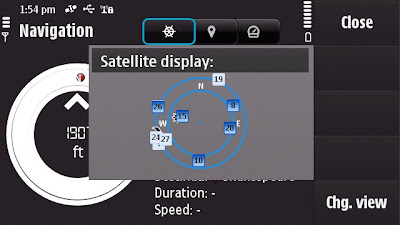
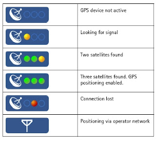
Satellite Status - BarSatellite Status - Radial
A quick note: Getting GPS Fixes faster. (less than a minute with 5 satellites
using standard GPS - no network based or A-GPS which uses the mobile
network to access GPS positional data)

The New N97 has more GPS details - in Applications>Location you can find
this in Position options Satellite Status will give you the signal strength of all
the GPS satellites available.
The view can be changed to Satellite display that gives the orbits on a radial
chart with sun and moon positions also. A nice feature, could this be implemented
in the Ovi Maps Application on the phone?

Back to the Maps:

What is New?
  • The map (vector) data has been completely updated
  • Current weather forecast information.
  • Speed Limit Warner
  • Saftey Spot Warner
  • Travel time or Time of Arrival option
  • Automatic 'Re-route' due to traffic option
  • Walking Directions has the option of straight-line distance to the destination.
  • Automatic 'Day/Night Time' Map mode.
  • Maps Improvement option.
  • *Compass mode (N97) Map rotates with you touch dragging (pan & zoom)
  • Search Nearby - vastly improved and more details available to users
  • Synchronisation with Ovi Maps Online. (confirmed this works very well)
  • Performance has been much improved (panning the map)
  • bugs fixed and is now a more stable application.
  • Better support and help - on phone or online option
Compass requires calibration before the function is available to use.


Traffic Information is now displayed on the Map even in 3D mode - Routes can be
automatic recalculated to avoid traffic incidents.

Smoothness, there has been a big improvement in the panning and zoom,
no jittering - when in driving navigating the map keeps up with the speed
of the vehicle. Navigation does repeat 3 times, one for advanced warning
- 350 yards. Then reminders at 50-30yds then 10 yards.

Walking mode does have the addition of straight line
'as the crow flies'
direction and distance.
(Golf players might use this to their advantage.)
Note the compass is 'green' meaning it is calibrated and active giving the
user the sense of bearing.
Walking Mode Straight line Navigation

Details on the map data:
v3.01 09wk24 b01 MV OpenGL LM MN
Map Version 0.1.22.103 OpenbitLM 6.21.3

Data souces:
NavInfo (Traffic info)
Satellite Imagemap 2002 - Planetary Visions
Imagery - Digital Global 2008
Aronbado por el Insitututo Geografico Milltar 5 Sept 2008.
STRM V4 2008 CIAT

update 25th January 2010 - New devices N97 (June 2009 onwards) Navigation is now Free
for life of the Phone. see
http://maps.nokia.com/explore-services/ovi-maps/downloads#/default/
Costs: (based on UK prices) - For Directions and Voice Navigation.
£52.99 for a year.(covers Europe).
£6.00 for 30 days.
£1.50 per day
*Pricing for other regions vary

1. Bug found: When using the 3D map option on the N97 - the touch screen only pans
upwards, the user cannot pan down the map.

Overall impressed with Nokia Ovi Maps 3 and where this application is going,
not only improving the software, the map data but introducing new and useful
features that engage and interacts with the user getting them to and from
locations conveniently.
Also the maps (vector data from Navteq now Nokia owned) are more up-to-date
than many online mapping
sources including TeleAtlas etc. (which Google uses).
At least areas that Mapperz has tested in so far.

This is the final beta stage of Ovi maps version 3. Expect the full release
in the next few weeks for
all current nokia phones that can support the application.

SportTracker Users will be happy to know that this is working for the N97 with
the touch screen controls.
Please visit Symbian World for more on this:
http://symbianworld.org/1187-sports-tracker-finally-
available-for-nokia-n97-and-5800/

Ovi Maps is a free application for S60 devices, though extra features
'Directions and Voice Navigation'
require licences that can be purchased
through the application.
More information
http://betalabs.nokia.com/betas/view/nokia-maps-30-maps-ovi

More details on the N97 Mapperz recommends:
http://www.allaboutsymbian.com/reviews/item/Nokia_N97
_Review-Part_1-First_impressions.php

http://www.allaboutsymbian.com/news/item/9902_Nokia_N97
_Review-Part_2-Touch-.php

A very special thanks to the team at http://www.womworld.com/nokia/
for a very successful 'Search for N' competition.


Labels: , , , , , , , , ,

03 November 2008

SatSki [Free Maps Coming Soon]

SatSki [Free Maps Coming Soon]

SatSki is making it's maps available for free for smartphones

"Satski is a touch screen colour GPS system which uses ‘real time’ while on the piste to plot user’s routes and guide skiers and boarders of all different levels around the resort, providing an easy to use, interactive piste map."


SatSki on SmartPhoneSatSki Google Earth Demo
[images sources: SatSki]

"As of 6th November Satski will provide FREE ski map downloads for smart phones. The Satski free downloads offers basic features such as piste/trial map and resort specific information"

Emergency Feature:
This feature provides crucial information for those in need of help and assistance from rescue services at the press of a tab the Satski software will allow the user in an
emergency situation to send their exact location coordinates to Mountain rescue/ Piste security (Longitude and Latitude) as well as their mobile phone number.
[if have a mobile/cell network]

source:http://www.satski.com/News.aspx

Labels: , , , , ,

23 September 2008

Nokia ViNe Alpha (Mapping)

Update 23/09/2008
There is now a Nokia Mapping Application available to view your 'geotagged' photos using
the new Nokia Photo v1.5 (Beta)

Nokia Photo Maps - Stacking Photos on Location
Multiple photos on the same geographical location are stacked.

For a full and in-depth review on the functionality visit

http://www.allaboutsymbian.com/news/item/8097_Nokia_Photos_15_now_available_.php

To download the Windows (Mac coming soon?)
http://www.nokia.com/betalabs/photos
(NokiaPhotos_1_5_200_en_gb.exe is a 53.8mb download)

Seems to me that Nokia are now competing with Google Picasa 3.
Though the Nokia application seems to be more seamless with loading geotagged photos from your phone and showing those photos on a map than Picasa is.
Maybe Picasa 4 will make use of the Google Map API and overlay photos onto that.... there is hoping.

Nokia ViNe Alp
ha (Mapping)
Nokia ViNe
Nokia ViNe application is currently in closed Alpha but the website is up and running.

"new geo-tracking-photo-and-video-and-music application"
Clinton Jeff - Darla Mack


Nokia ViNe Mapping Tracks
ViNe combines and uploads music, photos and gps tracks you record from your Nokia Device on one process.

Combine following applications:
Nokia Sports Tracker (Still Beta)
Nokia Lifeblog (Photos)
Nokia Music Player
GPS (GeoTagging)

Why the fuss? Why not use the applications that already exist?
It's one application that encapulates three applications and expands the mapping potential of geo-location tagged files (photo,music & video).
The Mapping is based in flash (website) - the users tracks link photo, music and videos that were captured when the ViNe Application is set to record.
There are concerns over the battery life - lucky for Nokia this is still in pre-release alpha and can be addressed before a public beta version.
Nokia's LifeviNe project has been renamed, it seems, to just Nokia ViNe.

There is nothing new but - for the non-savvy phone user it makes it easier for the user to record trip for sharing with friends afterwards.

For a more in depth review of the new application vist the Darla Mack Blog below where the whole process is shown.

Sources:
http://www.allaboutsymbian.com/news/item/8088_Nokia_ViNe-Practical_or_Pointl.php
http://www.darlamack.com/darlamack/2008/09/nokia-lifevine.html

At least Nokia are making use of Navteq data, now that Google Maps is completely TeleAtlas based.

Labels: , , , , , ,

12 September 2008

Virtual Earth News & Weather Silverlight Demo

Virtual Earth News & Weather Silverlight Demo

MapDotNet Virtual Earth US Radar Cloud Map
Very impressive Silverlight Demonstration showing weather (cloud/radar) across the USA.
(Hurricane Ike can be seen in the bottom right)

Silverlight 2.0 interface and Virtual Earth tiles with real time weather feeds showing current weather conditions.
There also is a radar refresh rate 5 minutes or 15 minutes


http://demo2.ischosting.net/weathersldemo/
[requires Microsoft Sliverlight]

Other geospatial applications that can be used with Virtual Earth:

* Windows Communications Foundation (WCF)-based web services
* Windows Presentation Foundation (WPF) Map and Tile renderer
* Virtual Earth Base Map Data and Imagery

* Silverlight 2.0 Map Control
* Spatial Data Import (Shapefile, SQL Server 2008, ArcSDE and PostGIS)

more information
http://www.mapdotnet.com/Pages2.0/index.aspx


An Up and Coming Virtual Earth Events

26 September 2008 11:00 GMT, London (so 12 noon as UK is on BST)

Following the success of the previous webcast, the second of our quarterly Virtual Earth technical briefings is once again presented by Johannes Kebeck, EMEA Virtual Earth Technology Specialist.

This webcast is aimed at developers and offers an opportunity to get an update on the Virtual Earth platform. Additionally you will learn some of the latest tips and tricks and can take part in an online Q&A with Johanne.

http://msevents.microsoft.com/CUI/WebCastEventDetails.aspx?EventID=1032385964&EventCategory=4&culture=en-GB&CountryCode=GB


The New Version of Virtual Earth

Thursday, October 02, 2008 9:00 AM Pacific Time (US & Canada) (5pm BST)

Microsoft is excited to announce the latest version of the Virtual Earth platform, which can now deliver the Virtual Earth mapping experience on the desktop, on mobile devices, and via broadcast. The new release features mobile support, expanded international mapping, richer imagery, a broader range of data, and improved functionality. Organizations using Virtual Earth can see more and do more than ever, with enhancements that allow users to find, discover, and visualize data in new and innovative ways.

http://msevents.microsoft.com/CUI/WebCastEventDetails.aspx?EventID=1032388370&EventCategory=4&culture=en-US&CountryCode=US


Virtual Earth Globalisation BBC
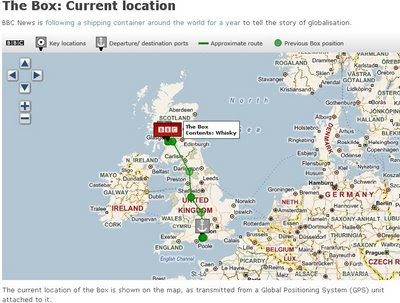
'The BBC BOX' that is getting tracked around the globe using a GPS beacon that is attached to a Shipping Container.
Not very exciting stuff currently but in a year hopefully the paths of the all the routes it has taken will be shown on the Map.
Update: They have just filled the BBC Box with whiskey in Glasgow.

THE BBC BOX MAP - Tracked
This Shipping Container is going to be tracked for a year.

BBC Virtual Earth is being used to track the box at a 12 hourly rate.

(Thanks to Keir Clarke for finding that one)

Labels: , , , ,

25 May 2008

Biggest GPS Self Portrait in the World

Biggest GPS Self Portrait in the World

GPS Self Portrait
55 days,over 100,000 km and 62 countries later...


"Artist Erik Nordenankar says he has created the Biggest Drawing In The World. He says he gave DHL a case and travel instructions for a 55-day journey, then traced the route using GPS. The route was more than 100,000km long and went through 62 countries. The result was a self-portrait."

Labels: , , , ,

01 February 2008

Nokia Internal vs External GPS

Nokia GPS Internal vs External
"The Nokia Bluetooth GPS Module LD-4W is for you if you’re looking for a navigation solution to send you effortlessly on your way. The lightweight, slim design makes this technology a great travelling companion" (AND DON'T HAVE AN INTERNAL GPS BUILT TO YOUR MOBILE PHONE)

Nokia GPS LD-4W Module
Nokia GPS Module - it's light, small and gets good fixes with good battery life.

(though users with built in Internal GPS (i.e.N95, N82 etc might be surprised on this independent review...)

GPS Module LD-4W generously supplied by WOM World, not only did they just supply a bluetooth GPS but also a Nokia N95.

Mapperz likes thank them once again for this opportunity.

Nokia says you can...With a Nokia Bluetooth GPS Module LD-4W you can: Turn your mobile device into a navigator (but only if you sign up to Nokia Maps with Navigation)Explore with GPS features on Nokia Maps, or compatible software (correct)tap in an address to Nokia Maps and let voice-guided directions take you there (see note 1)
Take it along with the belt clip or suction cup (yes it comes with this though you might not ever use it)
Operate up to 11 hours on a single, fast charge (fast charge is 1 hour approx -came with a car charge but not a mains charger, though you can use the N95 mains charger.)

If on a long trip 11 hours or more your likely to need a double car charger or if not driving out on the mountains then a Power Monkey is recommended.

Tech Spec:
The GPS Module Tech spec:

SiRF Star III LT, 20 parallel channels, Weighs 31 g (It is small and super light
Up to 11 hours, continuous tracking (so your phone will need a charge by then
Stand-by up to 4 days (seems pretty good for a small device
Typical ± 5-10 m (seem better than that most of the time with 8 or more satellites)1 second refresh rate-30°C up to +70°
Cold start (when the Nokia Bluetooth GPS Module has been switched off more than 2 hours): up to approx. 45 seconds on average - TrueHot start (when the Nokia Bluetooth GPS Module has been switched off for less than 2 hours): up to approx. 2 seconds on average - True
DatumWGS84 (world geodetic system) only - (this seems the main stream format these days)
Supports most Nokia bluetooth phones - though you will need a map application or tracking application to use it.

Here is Mapperz tested Map Application List...
Tested with:Google Maps Mobile (with 'My Location')


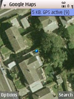
9 Satellite Fixes with Google Maps
Google Maps used the fully capacity of the GPS Module and got 9 satellites
(less than 4 metres in true terms)

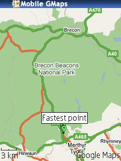
MGMaps (Internal GPS worked but failed to detect the paired bluetoothed GPS device)

Brecons Track KML MGMap

but does overlay kml from sport tracker

Yahoo Go! (beta 3) worked but no coverage maps of aerial for the UK (yet).
Yahoo_Go Beta 3.0

Maps24 (no gps tracking support but was 3D and has traffic alerts)
Map24 Options

All required a internet link either wifi or more likely GPRS when out and about.

combine these mapping applications and you will get a first class mapping application

**Though Nokia Maps was pre-installed and map data loaded onto the memory card - but will use mobile/cell network if required.
Nokia Maps - worked in the same way as the internal gps device as expected.Nokia Sports Tracker (v1.7) worked well as expected.
Nokia Navigation A40

Nokia Navigation, but beware of a few strange things - the route is correct but is the symbolisation?
Also told Mapperz to do a U-Turn on a dual carriageway!! though was traveling at speed.

The trial had almost ended from WOM World when Nokia Labs released Location Tagger (not used here) though see post.
Interesting the Nokia GPS device has 20 channels however their software seems only to support 5 channels (satellite fixes)

Google Maps Mobile used as many as 9 channels (max 12?) and seemed to get almost within a metre of 'my location' in several occasions.
*note to be fair the Assisted GPS and Network positioning was switched off as not all applications supported it.

Conclusion - if you have gps on your phone then you might not need to use this but if you want to take the strain off your mobile phone battery then you might consider this option, though remember that the bluetooth link will use battery life up too but not as much as internal gps chips.
Non-GPS phones (with bluetooth) that can install S60 mapping applications and want a nice little gps which does not need to be attached to the phone physically. This device is for you.

Price

Two options available:

The £59.99 version (just the module)

or the £169.99 version (includes Nokia Maps - but unsure if includes Navigation...)

Labels: , , , , , , ,

31 December 2007

Testing the N82 with Sports Tracker (Beta)

Testing the N82 with Sports Tracker (Beta)
Nokia N82 with Adventure Pack

Mapperz goes testing....N82 Sports Tracker (Beta) and Nokia Maps (phone, sports tracker software and bag generously supplied by WOM World)
http://www.womworld.com/nseries/category/n82/

Not going to go into details of build quality, looks or if it makes phone calls. There are plenty of other sites doing this.
Gets Go!

Sports Tracker enables the user to log or track your progress, it displays a pace, speed, altitude etc.
Official Full Details
http://research.nokia.com/research/projects/SportsTracker/

Sport Tracker Beta Site
http://sportstracker.nokia.com/nts/main/index.do (login required to use the service Free)

Mapperz coverage of the Sport Tracker Beta (previous post)
http://mapperz.blogspot.com/2007/11/nokia-sports-tracker-beta-map.html

Integrated GPS
Get as quick fix with the assistance of:

BlueTooth GPS (not needed)
A-GPS on
Integrated GPS on
Network Based on

Access point
GPRS (check default as will use WAP which is more expensive)
nokia server for A-GPS
supl.nokia.com

WOM wanted Mapperz to test out.
"Testing the sports trackers ability to track journey routes, along with other info regarding altitude, distance etc would be really interesting!"

So here is a train journey...
N82 Sports Tracker Beta in Google Earth

A tracking issue or gps issue?

N82 Sports Tracker Beta GPS errors?
Think the issue here is that the GPS and lack of 'field of view' to the sky.
A 'wobble' in the tracking - due a high filter correction method as default?
here is an interesting article
http://wubbahed.com/2007/07/12/gps-quality-on-the-n95/
Highlights the GPS being 'hyper-active' (note this was from an N95 with firmware updates)
The N82 seems better than the N95 for 'gps filtering'

Maybe there is a call for the A-GPS to be active on startup with an option to disable it on tracking mode (unless within an urban area). This should create a smoother tracking line.

Improvements: that could make this the perfect mobile map device:
  • Nokia please add the Nokia maps (map data) to the sports tracker. Not the navigational functions just the base map. (Mapperz has done this via Nokia Feedback). This would improve the usefulness of the application beyond 'tracking'.
  • Automatic screen rotation option to switch it off. Walking briskly with it in hand for using it in Nokia Map mode was jumping into landscape mode.
  • Ghost Tracking - where a previous track can be overlaid, very useful to runners, walkers etc would like to do the same routes in part of their routine.=
  • Imperial/Decimal Mode but with the option of Meters in Height (UK distance in Miles but UK height in Meters)
Spot the difference between Sports Tracker and Nokia Maps
Noticed when in Nokia Maps - the 'tracking' would snap to roads running along next to the railway. But the Sport Tracker did not.
This is a small issue - there must be some sort of rank - Motorways more important than Rail or A Roads on the Vector Map Data.
Have noticed that when going over a bridge going over a motorway/primary route the cursor snaps the major road rather than the road your are on.

N82 v N95
Not an easy one but there are improvements in the N82 over the N95.
Start up is faster & less crashing when running multiple applications
Camera Flash at night is much better on the N82 by miles.
Battery life has improved on the N95 (even after firmware v20).
But the N82 battery seems to go further than the N95 by about 6 hours (general use).
Screen size is a little smaller than the N95 but in general not any less functional.
It's slightly cheaper

If you want go for an unlocked N82 for 2008.
Test a N82 (limited places left)
http://www.nseries.com/index.html?l=campaigns,n82,demand#l=campaigns,n82,demand

If buying it - its worth getting directly from here at £399 +£3.99 standard delivery.
(you get a free bag.)
http://shop.nokia.co.uk/nokia-uk/product.aspx?sku=3759722&section_id=530&culture=en-GB

Clincher - N82 with TomTom - in Car
The N82 is a better navigational device for getting around London against the TomTom
XL Europe. why?
TomTom data was out of date and 'drop out' from GPS mode in between high buildings.
N82 had up to date data and no drop out was noticed (A-GPS and cell based positioning was on)

Full Spec of the N82 in depth.
http://www.gadgetnutz.com/modules/news/article.php?storyid=00420

Yes you can make and receive phone calls to.

Thanks to WOM World for the chance to test the phone and sports tracker.

Labels: , , , , , ,

27 December 2007

iPhone GPS

iPhone with GPS

  • better fix
  • better accuracy
iPhone LOCO GPS
iPhone with GPS Module


iPhone LOCO GPS dimensions
Loco GPS

Images courtesy of
http://partfoundry.com

More Information:
http://partfoundry.com/iphonegps.html


The GPS module will work on both the iPhone as well as the iPod touch

price
$89
£44.98

Labels: , , , ,

23 October 2007

A GPS Jacket on sale

A GPS Jacket on sale in the UK for £350

Trail Blazer GPS Jacket

  • GPS technology provides updates every 10 seconds
  • Firm says garment gives young more independence

Not sure on this...
So for your first year that is £350+£120 (£470)

If had a lifejacket (life preserver) option this would be more useful.

There is a children's version for £250+£170 for the paranoid parent.

So now there are trainers (sneakers/runners), Jackets. Next GPS trousers (pants)?

direct links
http://www.bladerunner.tv/product/details.php?id=trlbzr

http://www.bladerunner.tv/product/details.php?id=CHILDRENS

for that price I would want the 'drying mode' and 'self adjusting mode' of the 'back to the future' (part II) jacket

Source Guardian Unlimited
http://www.guardian.co.uk/technology/2007/oct/23/news.crime

Labels: , , , ,

05 September 2007

N95 Free Mobile Software (including Maps)

New N95 Free Mobile Software (including Maps)

reLive! Map London Demo

Nokia Download!
New
"Download! for PC enables you to discover mobile content using a PC. When you connect your mobile device to the PC, Download! for PC automatically synchronises with the corresponding software on your device. This makes it easy for you to find, download and manage content (maps) that is compatible with your device."
http://www.nokia.com/betalabs

Opera Mini 4 Beta v2
http://www.operamini.com/beta/
A Good Mobile Browser that allows you to view web based mapping now in landscape mode.

amAze 4.0
http://www.amazegps.com/index.php?page=countries&language=uk
The best Free Sat Nav For GPS enabled phones (includes N95)

Mosh Nokia New!
http://mosh.nokia.com/
"Your Stuff. Any Phone. Everywhere."
A good resource for finding and sharing Apps, Software,Music, Maps, Games, Pictures, Ringtones etc.

Local Search (Yell and Yahoo Search integrated with Map Option with results)
http://mobilesearch.nokia.com/A4160040


Mapperz Top Pick
reLive!
a unique and handy leisure application, allows you to take photos and write notes along your trip route, and seamlessly attach them to their locations on the map (geo-tagging).

reLive! Map

Demo ( in Flash)
http://relive.atlasct.com/map.asp
Download reLive! at
http://relive.atlasct.com/wap/ (via your mobile)

more info at
http://www.atlasct.com/Applications-ReLive.html

Labels: , , , , , , ,

29 August 2007

Ovi Nokia Maps Released

Ovi Nokia Maps Released for All - (Out of Beta!)

Nokia Maps Released

"London, UK – Nokia today introduced Ovi, the company’s new Internet services brand name. With the
introduction of Ovi, Nokia is expanding from a focus on mobile devices to offering a range of Internet services. Ovi, meaning ‘door’ in Finnish, enables consumers to easily access their existing social network, communities and content, as well as acting as a gateway to Nokia services."

Ovi Nokia consists of:
  • Nokia Music Store
  • N-Gage
  • Nokia Maps
  • *(more to be added)

Also under the Ovi umbrella is Nokia Maps, a navigation service that offers maps, city guides and more directly to compatible mobile devices. Nokia aims to bring more Internet based services to Ovi in the coming months.

Give me the links!

http://europe.nokia.com/A4509271 - Nokia Maps/Device Selector

http://europe.nokia.com/A4509291 - Introduction and how it works

http://ovi.nokia.com/ovi/flash/assets/

pdf/1_MeetOvi_Umbrella.pdf - Press Release (PDF)

http://nds1.nokia.com/files/support/global/phones/
guides/Maps_1_UG_en.pdf
User Guide (PDF)

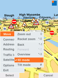
Nokia Maps GPS Fixes
GPS Fixes - the bottom icon costs you money with data transfer - Assisted GPS enabled (N95) only

Mapperz

Labels: , , , , , ,

23 August 2007

SatMap - A Sports GPS

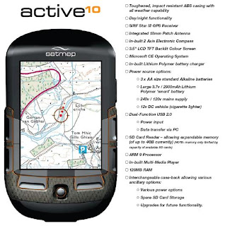
SatMap - A Sports GPS called the 'active10'

Sat Map Sports GPS

Source: © Satmap Systems Ltd

Specifically built for the UK Market. So it's waterproof!

Contains Ordnance Survey Mapping (on SD Card)

Easy to use
No computer is needed, just insert a map (SD Card) and go.

Real maps select from the wide range of titles
containing high quality maps supported by Ordnance Survey.
1:50,000 and 1:25,000 Mapping

Clear navigation
The intelligence of the active10 makes finding your way simple.SatMap Sports GPS Features

Source: © Satmap Systems Ltd

Internet links
A simple USB cable is all you need to connect to the Internet to download maps or share your favourite routes.

18 different titles, each one giving you all the 1:25,000 EXPLORER and 1:50,000 LANDRANGER maps on the trail making sure you stay on track.

UK Regions
10 different titles, each showing over 20,000 km2 of the country on a 1:50,000
LANDRANGER map giving you the freedom to roam throughout your region.

UK Counties
67 different titles, each on a 1:50,000 LANDRANGER map, allowing you to
focus on your favourite county.

Electronic compass
An internal electronic compass that works just like a standard hand-held compass.

Trip statistics
Automatically records route data so you always know how you are doing.

Price £300

Looks good and sounds great but a few questions

Does is export to KML?
Battery life?
Can you add your own mapping?
If you don't need PC how do you connect to the internet to share maps? (Built in Wifi?)

Technical Specs (PDF)
http://www.satmap.com/eshot/Satmap_product.pdf

http://www.satmap.com/eshot/Satmap_Tech_Spec.pdf

Labels: , , , , , ,

20 July 2007

Track Your Shoes (GPS Gadget)

GPS in your Shoes

Ever lost your shoes?

Here is a pair you can always find

GTXC GPS Shoe

"smallest lightest, most durable and powerful electronics on the market today

Interchangeable, waterproof and shock-proof module, from one shoe to the next"

http://www.gtxcorp.com/whatshot.htm

You can track your shoes and view the trail in Google Maps and Google Earth

Using Assisted GPS (now available in the N95 phone also)
PDF on this Technology (for geeks)

But can it recharge by walking?

Which shoe has the chip either or both?

Labels: , , , ,

01 July 2007

iPhone or N95?

Okay in simple terms why Mapperz bought an N95 and not an iPhone.

The iPhone has:
  • Touch Screen (3.5-inch (diagonal) widescreen multi-touch display))
  • Auto rotate
  • Maps (Google)
  • Quad Band (850, 900, 1800, 1900 MHz)
  • Wifi -Wi-Fi (802.11b/g) no n?
  • 2 Mega-pixel camera (my 5 year old camera has 3mega-pixel)
  • Limited Software available
  • A Polishing Cloth.
iPhone with Map no GPS!
Image:geothought.blogspot.com

Though it lacks one fundamental feature. GPS

If your going to have mapping on your phone, you want to know where you are, not Steve Jobs Office Location.

Just this one missing feature stops Mapperz pursuing the iPhone.

Location based information is useless unless it is providing information around your position or desired destination.

Now if Nokia and Apple produced a product together then it would be a better solution. But this is unlikely.

The N95 has done and is still doing it's job, however the information that phone has in its needs to be updated and cleaned. It is only a computer and can only give you the information it has.
(more map updates from TeleAtlas needed)

N95 has
  • GPS - Locates you in a few seconds (faster in the car with 12v of power)
  • Built in Maps - if you pre-load onto your memory card.
  • Built in Sat Nav with voice commands (if purchased)
  • 5 Mega-pixel camera.
  • Lots of supported software available.
N95 Maps GPS Active
Image:Allaboutsymbian.com

Mapperz own views, comment if you like.

Labels: , , , ,