->

28 May 2010

Spacebits.eu Launch Map

Spacebits.eu Launch Map (Live Tracking on 30th May 2010)

Spacebits1 live tracking map
The Launch and Tracking Dashboard.
This will be the Live Dashboard for the official launch of Spacebits 1 which is scheduled for the 30th of May, 2010, 11AM UTC/GMT+1.

Time of launch on other cities in the world.

  • 03:00AM Los Angeles USA
  • 06:00AM New York USA
  • 07:00PM Tokyo, Japan
The Project
"The goal for this project is to launch an High Altitude Balloon (HAB) with a computer probe to near space in Portugal. The Helium filled Balloon will go as high as 30.000 meters (that's about 100.000 feet), to the stratosphere, then explodes and the probe falls with a parachute and is recovered on earth."

Location of Launch
Scheduled for launching the Balloon on 30th of May, 2010 at Castro Verde, Portugal.


Ver mapa más grande

For much more information on the Project please visit http://spacebits.eu/

The Live Map will be here http://spacebits.eu/live (a demo mode is currently available).

Setup - http://spacebits.eu/page/spacebits1live.html

Good Luck to the Spacebits1 launch. follow on http://twitter.com/flyspacebits

Labels: , , , , , ,

23 September 2008

Nokia ViNe Alpha (Mapping)

Update 23/09/2008
There is now a Nokia Mapping Application available to view your 'geotagged' photos using
the new Nokia Photo v1.5 (Beta)

Nokia Photo Maps - Stacking Photos on Location
Multiple photos on the same geographical location are stacked.

For a full and in-depth review on the functionality visit

http://www.allaboutsymbian.com/news/item/8097_Nokia_Photos_15_now_available_.php

To download the Windows (Mac coming soon?)
http://www.nokia.com/betalabs/photos
(NokiaPhotos_1_5_200_en_gb.exe is a 53.8mb download)

Seems to me that Nokia are now competing with Google Picasa 3.
Though the Nokia application seems to be more seamless with loading geotagged photos from your phone and showing those photos on a map than Picasa is.
Maybe Picasa 4 will make use of the Google Map API and overlay photos onto that.... there is hoping.

Nokia ViNe Alp
ha (Mapping)
Nokia ViNe
Nokia ViNe application is currently in closed Alpha but the website is up and running.

"new geo-tracking-photo-and-video-and-music application"
Clinton Jeff - Darla Mack


Nokia ViNe Mapping Tracks
ViNe combines and uploads music, photos and gps tracks you record from your Nokia Device on one process.

Combine following applications:
Nokia Sports Tracker (Still Beta)
Nokia Lifeblog (Photos)
Nokia Music Player
GPS (GeoTagging)

Why the fuss? Why not use the applications that already exist?
It's one application that encapulates three applications and expands the mapping potential of geo-location tagged files (photo,music & video).
The Mapping is based in flash (website) - the users tracks link photo, music and videos that were captured when the ViNe Application is set to record.
There are concerns over the battery life - lucky for Nokia this is still in pre-release alpha and can be addressed before a public beta version.
Nokia's LifeviNe project has been renamed, it seems, to just Nokia ViNe.

There is nothing new but - for the non-savvy phone user it makes it easier for the user to record trip for sharing with friends afterwards.

For a more in depth review of the new application vist the Darla Mack Blog below where the whole process is shown.

Sources:
http://www.allaboutsymbian.com/news/item/8088_Nokia_ViNe-Practical_or_Pointl.php
http://www.darlamack.com/darlamack/2008/09/nokia-lifevine.html

At least Nokia are making use of Navteq data, now that Google Maps is completely TeleAtlas based.

Labels: , , , , , ,

12 September 2008

Virtual Earth News & Weather Silverlight Demo

Virtual Earth News & Weather Silverlight Demo

MapDotNet Virtual Earth US Radar Cloud Map
Very impressive Silverlight Demonstration showing weather (cloud/radar) across the USA.
(Hurricane Ike can be seen in the bottom right)

Silverlight 2.0 interface and Virtual Earth tiles with real time weather feeds showing current weather conditions.
There also is a radar refresh rate 5 minutes or 15 minutes


http://demo2.ischosting.net/weathersldemo/
[requires Microsoft Sliverlight]

Other geospatial applications that can be used with Virtual Earth:

* Windows Communications Foundation (WCF)-based web services
* Windows Presentation Foundation (WPF) Map and Tile renderer
* Virtual Earth Base Map Data and Imagery

* Silverlight 2.0 Map Control
* Spatial Data Import (Shapefile, SQL Server 2008, ArcSDE and PostGIS)

more information
http://www.mapdotnet.com/Pages2.0/index.aspx


An Up and Coming Virtual Earth Events

26 September 2008 11:00 GMT, London (so 12 noon as UK is on BST)

Following the success of the previous webcast, the second of our quarterly Virtual Earth technical briefings is once again presented by Johannes Kebeck, EMEA Virtual Earth Technology Specialist.

This webcast is aimed at developers and offers an opportunity to get an update on the Virtual Earth platform. Additionally you will learn some of the latest tips and tricks and can take part in an online Q&A with Johanne.

http://msevents.microsoft.com/CUI/WebCastEventDetails.aspx?EventID=1032385964&EventCategory=4&culture=en-GB&CountryCode=GB


The New Version of Virtual Earth

Thursday, October 02, 2008 9:00 AM Pacific Time (US & Canada) (5pm BST)

Microsoft is excited to announce the latest version of the Virtual Earth platform, which can now deliver the Virtual Earth mapping experience on the desktop, on mobile devices, and via broadcast. The new release features mobile support, expanded international mapping, richer imagery, a broader range of data, and improved functionality. Organizations using Virtual Earth can see more and do more than ever, with enhancements that allow users to find, discover, and visualize data in new and innovative ways.

http://msevents.microsoft.com/CUI/WebCastEventDetails.aspx?EventID=1032388370&EventCategory=4&culture=en-US&CountryCode=US


Virtual Earth Globalisation BBC
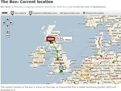
'The BBC BOX' that is getting tracked around the globe using a GPS beacon that is attached to a Shipping Container.
Not very exciting stuff currently but in a year hopefully the paths of the all the routes it has taken will be shown on the Map.
Update: They have just filled the BBC Box with whiskey in Glasgow.

THE BBC BOX MAP - Tracked
This Shipping Container is going to be tracked for a year.

BBC Virtual Earth is being used to track the box at a 12 hourly rate.

(Thanks to Keir Clarke for finding that one)

Labels: , , , ,

07 September 2007

VeoGeo Map (Video & Map Tracking)

VeoGeo Map (Video & Map Tracking)

VeoGeo Video Map Tracking

VeoGeo takes video sharing to the next level. Now you can map the activities you video, and share even more of the experience!

See what people from around the world are doing, and see where they’re doing it!

  • Capture your outdoor activities on your video camera
  • Capture a GPS record at the same time
  • Upload them to VeoGeo and share them with the world
This could take off with GPS and Video Capture on Mobile Phones.
The N95 could be used in conjunction with Sports Tracker and the 5 mega pixel camera.

VeoGeo Video Geotagged Map

As the video is played the map has a route and marker that moves in relation to the geographic position in the video. A nice touch is the graph that shows both speed/acceleration and elevation.

Labels: , , , ,

20 July 2007

Track Your Shoes (GPS Gadget)

GPS in your Shoes

Ever lost your shoes?

Here is a pair you can always find

GTXC GPS Shoe

"smallest lightest, most durable and powerful electronics on the market today

Interchangeable, waterproof and shock-proof module, from one shoe to the next"

http://www.gtxcorp.com/whatshot.htm

You can track your shoes and view the trail in Google Maps and Google Earth

Using Assisted GPS (now available in the N95 phone also)
PDF on this Technology (for geeks)

But can it recharge by walking?

Which shoe has the chip either or both?

Labels: , , , ,

28 November 2006

Real-time Sunrise and Sunset Tracking Map

Track the Sun setting or rising in real-time.
Sunset Sunrise Tracking Map - Zoomed Out

The map displays- in real time- the lines between the light (day) and dark (night) sides of the earth. This dividing line is known as the terminator. The parts of the earth that are crossing the terminator are where sunrises and sunsets occur.

As the map runs in real-time, you can watch different parts of the earth move from night to day (and vice versa).

Sunrise and sunset

You can choose between close-up views of the sunrise (night-to-day) and sunset (day-to-night) halves of the terminator. Sunrise (the part of the earth moving out of the shadow) is shown in yellow, moving across the landscape. Sunset (the parts of the earth moving into shadow) is shown in blue.

Latitude

Latitude is how far north or south of the equator (from 0 to 90 degrees) a place is. You can choose which latitude you want the view centred on. Either click the map (you may find navigation easier if you zoom out first) to centre on that latitude, or enter a value from +90 degrees (the North Pole) to -90 degrees (the South Pole).

Note that areas within the Arctic and Antarctic circles may be in permanent daylight or night during winter or summer, so it's impossible to show sunrise and sunset in such cases.

Labels: , , ,