->

26 October 2010

Evolution: European OpenStreetMap

Evolution: European OpenStreetMap

Evolution of European OpenStreetMap coverage from skobblertutorials on Vimeo.

Hence why Mapquest(Open) and Bing Maps (OSM App) are becoming more mainstream
Labels: , , , , ,

30 September 2010

TripGeo - Directions with Video Streetview

TripGeo - Directions with Video Streetview

"If you need a directions widget for your business, school or college you could do a lot worse than embed a free Directions Map widget on your website. TripGeo Directions uses Google Maps to help users create an embedable driving directions map for their website or blog.

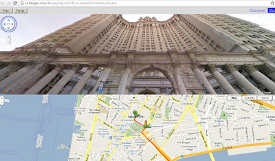
TripGeo - Directions with Video Streetview  NYC

The really fun part of this Google Maps based widget however is that it also allows you to create animated Street View tours. If you just add a starting point and a destination to Directions Map you can then view the route entirely in Street View.

Directions Map allows users to create driving directions from any starting point to any location. Users can also define the height, width and the map type of their widget. Once the widget has been embedded on a website it can then be used to follow the given driving directions or to view an animated walk-through of the route in Street View.

The animated walk-throughs of routes with Street View are very impressive. Given the impressive nature of these Street View animated routes I can see Directions Map also being used by websites to create virtual tours. In fact Directions Map has created a number of example animated Street View routes for locations around the world."
TripGeo - Directions with Video Streetview
Glide along with directions and video streeview (click play).
Here are links to some of the example animated Street View routes:

Chapmans Peak Drive, South Africa
Chateau d'Eox , Switzerland
Golden Gate Bridge
Colosseum, Rome
Las Vegas Boulevard
London, from the Houses of Parliament to the British Museum

Because Directions Map uses dynamic URL's you can even play about with the web address to quickly create your own routes by changing the start point and destination in the URL.

Here is the URL for New York to Boston:

http://s3.tripgeo.com/dirmap/map.htm?from=New%20York&to=Boston


If you want to view a Street View animation of the route from New York to San Francisco just change 'Boston' to 'San Francisco in the URL above. So what routes can you create. Post links to your routes in the comments below.

Update: microformats.dk has quickly created a page combining a Directions Map Street View tour of the Alpe d' Huez with a Kraftwerk YouTube video. Superb!

cross-posted from Google Maps Mania

Labels: , , , , ,

16 August 2010

Open Layers Heatmaps

Open Layers Heatmaps

"Making Open Street Maps even hotter!"

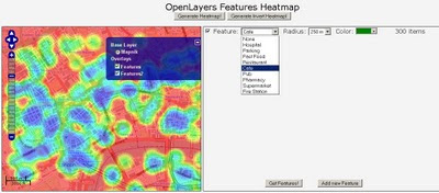
Open Layers OSM Heatmap
A Great Mashup to show 'HeatMaps' using Open Layers and Open Street Map Features (OSM).
Select a number of OSM Features and create dynamic heatmaps from them.
Note: this is the 'inverted' heatmap view.

Credit to Felipe Barriga (http://blog.felipebarriga.cl/)

If you want to create your own HeatMaps the source code is available via OLHeatmap.


What is OLHeatmap ?

OpenLayers Heatmap is a group of hacks ( talented programmers) to render heat maps over OpenLayers. At this moment is very ugly and dirty but I have some ideas in mind to make this a more presentable project....

Why that name ?

OLHeatmap stands for OpenLayers Heatmap

Video Demo


Video via http://opengeodata.org/osm-heatmaps-in-the-browser-w-openlayers

Heat Map
http://blog.felipebarriga.cl/olheatmap_demo/

Source:
http://blog.felipebarriga.cl/programacion/olheatmap-live-demo/

Labels: , , , ,

23 September 2008

Nokia ViNe Alpha (Mapping)

Update 23/09/2008
There is now a Nokia Mapping Application available to view your 'geotagged' photos using
the new Nokia Photo v1.5 (Beta)

Nokia Photo Maps - Stacking Photos on Location
Multiple photos on the same geographical location are stacked.

For a full and in-depth review on the functionality visit

http://www.allaboutsymbian.com/news/item/8097_Nokia_Photos_15_now_available_.php

To download the Windows (Mac coming soon?)
http://www.nokia.com/betalabs/photos
(NokiaPhotos_1_5_200_en_gb.exe is a 53.8mb download)

Seems to me that Nokia are now competing with Google Picasa 3.
Though the Nokia application seems to be more seamless with loading geotagged photos from your phone and showing those photos on a map than Picasa is.
Maybe Picasa 4 will make use of the Google Map API and overlay photos onto that.... there is hoping.

Nokia ViNe Alp
ha (Mapping)
Nokia ViNe
Nokia ViNe application is currently in closed Alpha but the website is up and running.

"new geo-tracking-photo-and-video-and-music application"
Clinton Jeff - Darla Mack


Nokia ViNe Mapping Tracks
ViNe combines and uploads music, photos and gps tracks you record from your Nokia Device on one process.

Combine following applications:
Nokia Sports Tracker (Still Beta)
Nokia Lifeblog (Photos)
Nokia Music Player
GPS (GeoTagging)

Why the fuss? Why not use the applications that already exist?
It's one application that encapulates three applications and expands the mapping potential of geo-location tagged files (photo,music & video).
The Mapping is based in flash (website) - the users tracks link photo, music and videos that were captured when the ViNe Application is set to record.
There are concerns over the battery life - lucky for Nokia this is still in pre-release alpha and can be addressed before a public beta version.
Nokia's LifeviNe project has been renamed, it seems, to just Nokia ViNe.

There is nothing new but - for the non-savvy phone user it makes it easier for the user to record trip for sharing with friends afterwards.

For a more in depth review of the new application vist the Darla Mack Blog below where the whole process is shown.

Sources:
http://www.allaboutsymbian.com/news/item/8088_Nokia_ViNe-Practical_or_Pointl.php
http://www.darlamack.com/darlamack/2008/09/nokia-lifevine.html

At least Nokia are making use of Navteq data, now that Google Maps is completely TeleAtlas based.

Labels: , , , , , ,

06 March 2008

Master Class: Creating Custom Maps

Creating Custom Maps with John Coryat

How do you do 'Custom Tiles' in Google Maps?

An excellent presentation explains it all.

Software/scripts required
Perl 5.8 with DBI, GD and CGI modules
USNaviguide_Google_Relpix Perl module
USNaviguide_Google_Tiles Perl module
PostgreSQL 8.2 with PostGIS Extension (Mapperz recommends PostgreSQL)
Apache 2.0 webserver
ProjectedImage.js (Javascript)
US Census Cartographic Boundary County Shapefiles
Geonames.org US.zip data file

Or the PDF version

http://www.usnaviguide.com/ws-2008-02/presentation.pdf(5.5mb file)

Examples and Presentation Materials
http://www.usnaviguide.com/ws-2008-02/download.zip (111mb file)

Well done http://maps.huge.info/blog

Labels: , , , , ,

29 February 2008

Worldwide Telescope Video (Microsoft)

Worldwide Telescope Video (Microsoft)


source:
http://www.ted.com/talks/view/id/224

Labels: , , ,

10 February 2008

Carmenta Mobile (N95)

Carmenta Mobile
'The future of maps in mobile phones'


"Carmenta Mobile is a high performance map engine for mobile phones, targeting companies that want to provide advanced Location Based Services applications around maps, routing and geocoding"

Carmenta Mobile can be easily embedded into a mobile application as it provides a rich set of features such as:

  • 2D and 3D maps with 3D buildings and landmarks
  • Onboard and/or offboard (loaded from server) maps
  • Maps as images or vector data
  • In-car personal navigation
  • Pedestrian personal navigation
  • Friend finder
  • Proximity search, “where is the closest restaurant from my location”
  • Location based games
  • Tracking
  • Fleet management

video: http://www.youtube.com/watch?v=iBGvkmmSkWI

http://www.carmenta.com/company is a company producing high-class geospatial software products.

Labels: , , , , ,

07 September 2007

VeoGeo Map (Video & Map Tracking)

VeoGeo Map (Video & Map Tracking)

VeoGeo Video Map Tracking

VeoGeo takes video sharing to the next level. Now you can map the activities you video, and share even more of the experience!

See what people from around the world are doing, and see where they’re doing it!

  • Capture your outdoor activities on your video camera
  • Capture a GPS record at the same time
  • Upload them to VeoGeo and share them with the world
This could take off with GPS and Video Capture on Mobile Phones.
The N95 could be used in conjunction with Sports Tracker and the 5 mega pixel camera.

VeoGeo Video Geotagged Map

As the video is played the map has a route and marker that moves in relation to the geographic position in the video. A nice touch is the graph that shows both speed/acceleration and elevation.

Labels: , , , ,

15 January 2007

Gchart - Currency, Local Time and Weather Map

Gchart Currency Map
Gchart - Currency, Local Time and Weather Map all available on from one source and one map.
Simple and a easy to use.

Also mapped is video and web blogs

Mapperz (now with rss email feed - visit blog to subscribe)

Labels: , , , , , ,