->

30 March 2007

Find the Vine - Search by Grape or Wine

A nice website for all you wine connoisseurs (including mapgirl)

Find the wine map site
Search by Appellation d’origine contrôlée (AOC) or by grape.

Nice and clean website findthevine.com full of wines from France and a Google Map showing you the geographical locations where the grapes vines and wine production is.

Find the wine google map
Notice the Gpolygon from the Google Maps API is used on this site.

"I'd been wanting to learn more about French wine, so hit upon the idea of merging the legal texts about French A.O.C's from http://www.inao.gouv.fr/ with Google maps, to represent where different wines are grown.
Your post http://mapperz.blogspot.com/2007/01/google-maps-and-topology.html was very helpful in getting the GPolygon working in IE6."
Graham King - Google Map Maker and wine enthusiast (http://www.darkcoding.net/index.php)

mapperz reply - your very welcome.

Labels: , , , , ,

29 March 2007

ESRI ArcGIS 9.2 Service Pack 2

update: 17/04/2007
For more information on ArcGIS Service Pack 2
http://mapperz.blogspot.com/2007/04/arcgis-92-service-pack-2-released.html

ArcGIS Service Pack 2 Announcement

ArcGIS 9.2 Flyer
Image Source ESRI (UK) - scribble by mapperz

Okay this is a summary due to the large number of bug/fundamental errors in ArcGIS 9.2 (Service Pack 1)

This is truly amazing to see after ESRI did extended beta testing of ArcGIS 9.2

One missing in this is the recently found projection problem - If you have a World Database and it is in Geographic and projection on the fly into Vander Grinten then change the central meridian to 155 degrees
nothing happens! (thanks ESRI - lucky we have 9.1 (SP3) running which works without a hitch)

Come on ESRI produce better software - remember most companies are paying thousands of pounds (and dollars) for the software + thousands more for maintenance.

But where is the compensation when you have lost 100's of production hours migrating to from 9.1 to 9.2 and finding out stuff did work and now does not!


Mapperz Top 10 bugs (fixed? we hope so...)
1.
NIM004761 - BasicGeoprocessor clip doesn’t work at ArcGIS release 9.2.
2.
NIM005308 - Maplex does not produce labels in some situations with data drawn in Geographic Coordinate System.
3.
NIM005313 - ArcCatalog may crash when trying to create a backup using Personal and Workgroup ArcSDE geodatabases if the user creating the back up is a geodatabase administrator and an administrator on the local machine
4.
NIM005500 - Batch Project Script returns an "Error failed to execute" when trying to run script.
5.
NIM005575 - In 9.2, when highlighting a subset of records in Selected View and pressing Delete in edit mode, only the highlighted records should be deleted (as it is in 9.1); instead all selected records get deleted

6.
NIM006180 - When you compress a file geodatabase dataset, any text attribute longer than 256 characters truncates to 256 characters.

7.
NIM006254 - Calculating an angle for annotation in the angle field fails on a single point geometry.

8.
NIM006313 - On some Windows machines, installing ArcGIS 9.2 can cause raster projection not being recognized.

9.
NIM006640 - Adding a spatial index to large shapefiles may fail.

10.
NIM006783 - Representation layers may lose CMYK color information on export to PDF, EPS, SVG, and AI formats.

Full list (have at least 10 mins spare with caffeine)

So try
MapInfo Professional
CadCorp
AutoDesk


ESRI - remember there are some very good open source GIS applications out there. With the likes of

Mapserver
(very easy to configure - Internet Map Server like ArcIMS but FREE)
QGIS - coming along strong - supports postgres (ESRI were to support Postgres??)

Even Google Earth is becoming a GIS for the general public to create spatial information

Labels: , , ,

Useamap - Tinyurl for Maps

Useamap a tinyurl for Maps- Mapperz recommended

Mapperz Useamap
http://useamap.com/mapperz

"A free site which your readers might indeed find useful. It allows you to save a location for an event with a short URL. For example, if you are having a meeting with your clients, you can save your office location with a link like 'useamap.com/office_meeting' on a map . It is very easy to embed the map onto your blog or website and anyone going to your location can get detailed driving directions to your place."

This site does what it says, very handy and good sized maps, directions are supplied using MapQuest Open API and works well

Useamap Directions

Note: This site uses it's own geocoding service and is fast.

Nice work and thanks to Vincent Glennon (useamap.com)

Labels: , , , ,

28 March 2007

StreetAdvisor

Find out about the local area before you move

StreetAdvisor
http://streetadvisor.com/

"StreetAdvisor is the easy way to find out what people REALLY think about the street they live in. It’s a place where people can finally voice their opinions about where they live, have lived or simply visited"

Using a search you report on Mobile Phone Coverage, Nightlife, Schools and many other amenities.
A very useful service where the more that use it the better the service becomes.


mapperz


Labels: , , , ,

19 March 2007

Europe Weather Alert Map

Wind
Extreme high temperature
Rain
Extreme low temperature
Snow/Ice
Coastal Event
Thunderstorms
Forest Fire
Fog
Avalanches

MeteoAlarm (Weather) Map
all mapped here, okay not the most dynamic mapping (static images updated on alert) but to make it available in 12 languages is very help to traveling Europeans, though no Welsh or Gaelic.

mapperz

Labels: , , , , ,

17 March 2007

WMS & WFS Google Maps + KML

Oxford Archaeology opened up their data with a Web Mapping Service

Online Archaeology
has a good couple articles on both services. In summary here:
  • Web Mapping Service (WMS) produces maps of spatially referenced data dynamically from geographic information.
wms service in google maps online archeology
Live link for WMS
http://www.online-archaeology.co.uk/GoogleMap/Pages/oa.htm


  • Web Feature Service (WFS) is an interface allowing requests for geographical features across the web using platform-independent call.
wfs service in google maps
Live Link for WFS
http://www.andrewlarcombe.co.uk/index.php/oa


The future of Web Features/Map Services?
These services will have to make room for the KML (Keyhole Markup Langauge) format that seems to becoming a standard in its own right.

And the inclusion of this 'GGeoXML' integrating kml format with Google Maps API
hinted on the Google Maps API group in the next version of the API (2.76) has great potential in making thousands of features available to view to the world.
When available will have a post here on the mapperz blog about it.


Labels: , , , , ,

15 March 2007

Your Map Data to KML

Update 09/08/2007

WHAT'S NEW IN VERSION 2.3:
- graduated marker symbols are now supported
- multi-part features are now supported
- the feature name can now be explicitly defined
- bunch of other bug fixes, minor tweaks and improvements

INSTALLATION:
Refer to "Export_to_KML_Documention.pdf" for information on installing
and uninstalling the extension.

NOTE:
This is a free, open source product. While I'll continue to make improvements,
if you need much more sophistication than this tool offers,
check out the commercial software.

RECENT FIXES (Version 2.3):
6/12/07 - updated documentation; added uninstall script
5/10/07 - fixed issue with circles and curves not being exported from geodatabases
3/27/07 - removed unnecessary leading commas from KML coordinates; makes output
KMLs compatible with Google Maps API


Your Map Data to KML for use in Google Earth or Google Maps
(and gain more visitors to your site/blog)

mapperz cities kml in google earth from shapefiles indexed
World cities in Google Earth from a Shapefile

mapperz cities kml in google maps from shapefiles
KML to Google Maps
So you have vast amounts of data offline?

You want more Visitors to your website.

Here is an unofficial and not supported post to boost your audience using geographical data.

Have tested this and works. mapperz

Ingredients
  • 1 Webserver (or free service like Google Pages)
  • Some data (say shapefiles of UK Towns)
  • A little bit of code (honest it's only little bit)
  • some links
OK here is some data in a Full fledged GIS

UK towns in British National grid arcmap

your right it a bit boring! and what has this got to do with KML?

OK for this to work you need your GIS data in WGS84 format.

In your GIS (in this case ArcMap) Project the data using project in the toolbox

Note:If you data does not have a .prj file with shapefiles use define projection before the project command.

This will make the data into Geographic projection (yes you will be able to overlay it in google map and google earth in a minute)

Now do a Calculate (ArcGIS 9.2 users have it easy by using the Calculate Geometry option)


UK towns in Geographic projection arcmap

pre 9.2 you need to create two fields x&y or lat&lng

if doing this a lot easier if you use the free code from Ianko Tchoukanski


So now you have the geographical values.

Using ArcGIS and a free script

Export to KML 2.3.4

http://arcscripts.esri.com/details.asp?dbid=14273

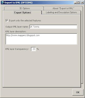
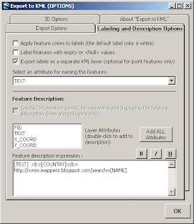
"Export to KML is an extension developed for ArcGIS 9.x by the City of Portland, Bureau of Planning. The extension allows ArcGIS users to export GIS data in “keyhole markup language” (KML) format for viewing in the free Google Earth data viewer. Any point, polyline, or polygon dataset, in any defined projection, can be exported. Features can be exported as either 2-dimensional features, or 3D features "extruded" upwards by an attribute or z-value. Some other features: ability to incorporate ArcMap layer symbology into the exported KML; labeling of point, line, and polygon features; "describe" individual features using the database attributes."

shape to_kml

Shapefiles to KML Options


Please note: you will be making this data available to the whole world and make sure you own copyright to the data.

Why all this effort?
Make Kml available helps your potential users find you/your website/blog as google seem to be ranking geographical data higher than other web formats (plain old html, xml).
Making your kml available online is also available through the google earth application and with 200 million downloads, it is going to help pull people towards your website.
Remember content is King.

Working Examples
Google KML File Directory (for Example purposes)
http://mapperz.kml.googlepages.com/home
View in Google Earth of the Option of viewing in Google Maps

sitemap (key to indexing kml files)
http://mapperz.kml.googlepages.com/sitemap.xml


Sources:
http://googlemapsapi.blogspot.com/2007/01/get-more
-traffic-to-your-maps-api-site.html
http://www.sitemaps.org/protocol.html
http://www.google.com/apis/maps/sitemap.html

MIME types to the server and Network Links
  • application/vnd.google-earth.kml+xml kml
  • application/vnd.google-earth.kmz kmz
http://googleearthuser.blogspot.com/2007/03/
posting-kml-on-web-server.html


Labels: , , , , ,

13 March 2007

Google Earth in Tandem

Your friends can now follow along with you in Google Earth

Unype via Skype sharing Google Earth locations

required
  • a friend
  • Skype (voice/video over ip)

Synchronising two users with Google Earth installed on each others pc, using the popular skype program to send the information and unype sends basic kml to the viewers google earth app.

Good for demo's and showing friends places.

more info and video
http://digitalurban.blogspot.com/2007/03/skype-goolge
-earth-multi-user-google.html

http://www.gearthblog.com/blog/archives/2007/03/
skype_unype_multiuse.html

Source: Nafcom

Labels: , , , , ,

09 March 2007

Google Maps Photos - Geotagged

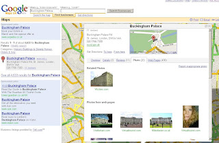
Google now maps relates photos by description (geotagging)
http://en.wikipedia.org/wiki/GeoTagging

Google Map Geotagging Photos Related to Map Search
Find 'Buckingham Palace' returns Map and Photos

This a form of Metadata where information about the data you search on is returned

Other possibilities for metadata are

Statistics (Area, Height, Volume)
Historic (This building was build in)
Structure (This Building is made from)
the list goes on...

Labels: , , , ,

08 March 2007

3D Berlin - Google Earth

3D Berlin - Google Earth - The Official Berlin 3D City Model

Berlin in 3D Google Earth
Nice Building Textures

Inside 3D IMAX Building Google Earth
Inside IMAX in Google Earth

In English or in German

Fast internet connection required 2mb+

mapperz

Labels: , , , ,

07 March 2007

Mole-Whacker Map

Whack A What?
Well it's an official and latest example from Google Map API Blog http://googlemapsapi.blogspot.com/
Whack A Mole Map
More info and code
The map in an interactive game form shows by example what can be done with new code in the 2.75 version of Google Maps API

Another timely named March Marker Madness: GMarkerOptions
show you the code changing underneath the map, very useful for non-coders ( like mapperz) to show what is going on under the hood.

Good to see helpful and fun examples, more please

No real moles were harmed in the creation of this post.

Labels: , ,

05 March 2007

UK Geocoder Map - via AJAX

UK Geocoder Map - via Google AJAX Search

Type your postcode in and there it is on the map!

Type in a postcode
sw1A 2aj
For example

UK Geocoding Map AJAX
Supports UK Addresses too

For example
10 downing street london

UK Geocoding Addresses Map AJAX

that easy.

Thanks to http://www.farnhamknights.com/ash/google_maps.asp

top tips: lowercase seems to be faster and do not add commas to the search.

suggestion: to be a geocoder coordinates need to be returned ( the longitude and latitude in this case)
mapperz

Labels: , , , , ,

Save Your Post Office Map!

Post offices in crisis: the map

Save Your Post Office Map
Britain's first and only interactive campaign map designed to highlight the state of our post offices.

Using the map:
"To open a report and post your comments, pictures and videos, click on a postbox symbol or the right hand links. For a closer look at a particular location, use the 'Zoom in' link. Otherwise, scroll around using the arrows or your mouse. Note: some maps for more remote rural locations may be low quality or missing - use the [+} and [-] buttons to make necessary adjustments."

more details on this hot topic: Silent assassin stalking your local post office

Add your Post Office Contact:
postoffices@thisismoney.co.uk

Map information:

MapKit was use to create the embedded Google Map provided by platial.com

Think of all those people who do not drive and cannot get to a Main Post Office, for some it is the hub of the community.
Some are having to travel up to 14 miles to get to a post office - it's a UK service.
Find your nearest Post Office here

Mapperz

Labels: , , , ,

04 March 2007

Ordnance Survey New Product - Sitemap™

Ordnance Survey Releases A New Product - Sitemap™

Ordnance Survey Sitemap™
Image Source: Ordnance Survey

"OS Sitemap provides customers with extracts of Ordnance Survey mapping in a number of different formats and to different scales. It is has been developed to suit the requirements of a broad range of customers - from private individuals requiring a paper map to large design and engineering organisations wanting map data to be used within a computer system."

OS Sitemap provides a detailed and seamless view of topography of Great Britain:
Three scales
  • 1:1250 (Derived from OS Master Map)
  • 1:2500 (Derived from OS Master Map)
  • 1:10 000

Available in Paper (Colour or Black and White)
Raster Images (LZW compressed Tiff or PDF format)
Vector (DXF but not NTF or GML)

But is it cheap?
No, cheaper than OS Master Map but for Personal use and even small businesses it is expensive. Use Open Street Map (free) as an alternative instead.

Prices, the PDF just points to Sitemap at the end available at Ordnance Survey Mapping and Data Centres, it depends on a number of factors

Raster or Vector formats
Colour or Black and White
Size of Area needed
and complex pricing structuring dependant on your use, commercial vector on a website will lead to many ££££.

To find your nearest stockist

60 Layers of Features however here are some that are Not included are

Roads under 100 metres (Private Land)
Rights of Way
Detail under bridges (so captured from aerial photography and not surveyed?)
Detail under elevated roads
Buildings below a minimum size (resolution of image not high enough to capture it?)
Land parcel areas and House Numbers

Good for Ordnance Survey to create new digital products, however they need to make purchasing and costs more accessible to the public.
If they reduce prices they would gain more customers and not scare many off with complex pricing, are all 47% of Ordnance Survey is paid by the tax payer.
so do UK tax payers with get a 47% discount with that?

mapperz
likes OS products and uses them most days in a commercial sense, though OS need to make it easier and cheaper for Joe Public to use it for personal use.

Labels: , , , , , , , , ,

02 March 2007

Swiss Alps Super High Res in Google Earth/Google Maps

Swiss Alps in Glossy Super High Res in Google Earth/Google Maps

Swiss Alps High Res

Google announce another imagery and terrain update:

Highlights are:
  • Entire country of Switzerland at 50cm and many Swiss cities at 25cm ( courtesy of Endoxon)
  • Entire country of Switzerland terrain at 10m, the Swiss Alps are now super high-res!
  • Entire country of Denmark at 50cm
  • Australia day flyover
  • Cities of France: Lyon; Le Mans; Lourdes; Reims; Nancy; Limoges; Lille; Arles
  • Potsdam and Magdeburg, Germany
  • Barcelona, Belem, CapeTown, Galapagos (Isabella Island), Manaus, Mt Saint Helens, Recife, Rio, Venice)
  • Full state coverage for Wyoming & Utah
  • Significant amounts of new Digital Globe data
Google now shows you the dates of the images

Google Earth Image Dates

select 'Digital Globe Coverage' in the Layers to view this information (useful for reference)


Source: http://bbs.keyhole.com/ubb/showthreaded.php/Cat/0/Number/815618
Via: The Map Room
More Links at Google Maps Mania

More info over at Ogle Earth

Labels: , , , , ,

01 March 2007

'Faulty' Fuel Map

'Faulty' Fuel Map locations spreading across the UK.

Faulty Fuel UK Map
Image Source: BBC News

Fuel Outlets have been suppling the UK with Fuel that has been "contaminated"
More on this here:
http://news.bbc.co.uk/1/hi/uk/6409025.stm

But if you have a Vecta-DeLoran your be okay

"I have a nano-silver nutron converter fitted to my Vecta-DeLoran. I just empty waste material into its processor to generate the power I require. I have used empty Tesco carrier bags and wrappers in the past but I found McDonalds waste produces a nice smell."

said StevieB, from Staines

update: traces of silicon have been found in petrol taken from the cars

final update: A Result
http://news.bbc.co.uk/1/hi/uk/6421783.stm

Labels: , , , ,