->

19 September 2007

Brighti Solutions - GeoData to GeoRSS

Brighti Solutions - GeoData to GeoRSS

Get your data unlocked and web ready. It's quick and clever
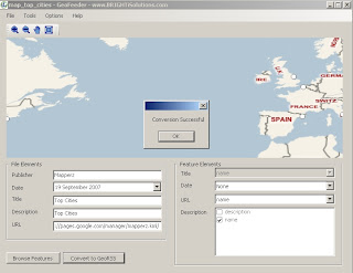
Brighti Solutions GeoRSS Output
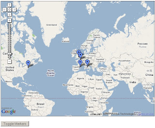
At first glance locations seems displaced. But in the Google map (below) locations are in the correct location.

"Yet the problem remains that most geodata is locked away in formats that don't play nice with the major web mapping providers"

"That’s where BRIGHTi GeoFeeder comes to the rescue"

  • Convert to all variations of GeoRSS formats including RSS, ATOM and Simple,GML,
  • Works with the following formats/extensions: .kml, .kmz, .gml, .shp, .mif, .dxf
  • Convert vector data (points, lines and polygons) to GeoRSS
  • Map feature attributes to GeoRSS attributes
  • Specify multiple attributes for elements
  • Displays all features on a Virtual Earth map
  • Browse features and attributes
  • Zoom and pan
Brighti Solutions GeoRSS Google Map
This map took 30 seconds to create - code from the official example
http://www.google.com/apis/maps/documentation/
examples/geoxml-rss.html
*change api key to your website
*change url of the georss.xml (GeoRSS file)
done!
Nice work.

Suggestions
More formats please
hyperlinking urls (like to products - this can be done if edit the xml file)
feedback forum to share issues and solutions

Labels: , , , , , , , ,

04 March 2007

Ordnance Survey New Product - Sitemap™

Ordnance Survey Releases A New Product - Sitemap™

Ordnance Survey Sitemap™
Image Source: Ordnance Survey

"OS Sitemap provides customers with extracts of Ordnance Survey mapping in a number of different formats and to different scales. It is has been developed to suit the requirements of a broad range of customers - from private individuals requiring a paper map to large design and engineering organisations wanting map data to be used within a computer system."

OS Sitemap provides a detailed and seamless view of topography of Great Britain:
Three scales
  • 1:1250 (Derived from OS Master Map)
  • 1:2500 (Derived from OS Master Map)
  • 1:10 000

Available in Paper (Colour or Black and White)
Raster Images (LZW compressed Tiff or PDF format)
Vector (DXF but not NTF or GML)

But is it cheap?
No, cheaper than OS Master Map but for Personal use and even small businesses it is expensive. Use Open Street Map (free) as an alternative instead.

Prices, the PDF just points to Sitemap at the end available at Ordnance Survey Mapping and Data Centres, it depends on a number of factors

Raster or Vector formats
Colour or Black and White
Size of Area needed
and complex pricing structuring dependant on your use, commercial vector on a website will lead to many ££££.

To find your nearest stockist

60 Layers of Features however here are some that are Not included are

Roads under 100 metres (Private Land)
Rights of Way
Detail under bridges (so captured from aerial photography and not surveyed?)
Detail under elevated roads
Buildings below a minimum size (resolution of image not high enough to capture it?)
Land parcel areas and House Numbers

Good for Ordnance Survey to create new digital products, however they need to make purchasing and costs more accessible to the public.
If they reduce prices they would gain more customers and not scare many off with complex pricing, are all 47% of Ordnance Survey is paid by the tax payer.
so do UK tax payers with get a 47% discount with that?

mapperz
likes OS products and uses them most days in a commercial sense, though OS need to make it easier and cheaper for Joe Public to use it for personal use.

Labels: , , , , , , , , ,