->

23 August 2010

Spatial Data Viewer on Bing Maps App

Spatial Data Viewer on Bing Maps App

View
  • ESRI Shapefiles (.shp & .dbf files) [best under 300k]
  • GeoRSS Feeds (.xml with lat & lng)
  • Well Know Text (WKT)
Known as Ricky's Data Viewer
Bing Maps Shapefile Viewer
Loaded Shapefile (World Countries) in the Data Viewer using 'select shapefile' option, .dbf if your want to see attributes (table data).

Bing Maps Viewing GeoRSS Feeds
GeoRSS (.xml) recent earthquakes feed from (USGS)

Full list of Bing Maps Apps.

Labels: , , , , ,

29 January 2010

Mobile GeoRSS Maps *Beta* (Map Channels)

Mobile GeoRSS Maps *Beta* (by Map Channels)
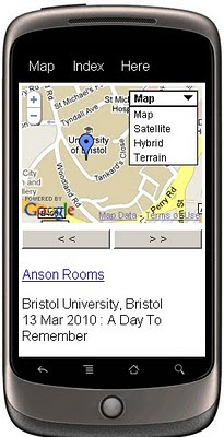
"The easy way to add mapping for mobile websites"

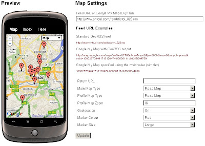
Mobile GeoRSS Maps combines the Google Maps v3 API and Google Feeds API to display a GeoRSS feed on a map that is optimized for mobile phone display.

Mobile GeoRSS Maps
Create your own Map with feeds for your mobile, mymaps or georss feeds can auto-update and provide you with latest information whilst on the move.

Use Mobile GeoRSS Maps to simply add your map to your mobile website, or to generate a map link for emailing.

Google My Maps are supported. Use Mobile GeoRSS Maps to generate a mobile version of a My Map in seconds.

Mobile GeoRSS maps works on any phone which supports the Maps v3 API, such as the iPhone and Android or Symbian platforms.

Mobile GeoRSS Maps Preview
Simple instructions to set you up for adding your own feeds to your mobile.

Technical Notes:

This map is a *beta* project, please contact us if you notice any bugs.

Only placemarks in a feed are displayed (lines and polygons are not displayed)

A maximum of 200 placemarks are displayed on the map

Custom Marker styles contained in a My Map are not displayed

base url for the following parameters
http://data.mapchannels.com/mobmap/100/map.htm

f = Feed URL or My Maps ID
r = Return URL
mt = Main Map Type (1=Road Map, 2=Satellite, 3=Hybrid, 4=Terrain)
pt =Profile Map Type (1=Road Map, 2=Satellite, 3=Hybrid, 4=Terrain)
z =Profile Map Zoom (between 1 and 20)
g =Geolocation (0=Off 1=On)
c =Marker Colour (0=Red 1=Blue 2=Green 3=White)

example:
http://data.mapchannels.com/mobmap/100/map.htm?g=1&mt=1&pt=1&z=16&c=0&s=1&f=http://www.entcal.com/rss/bristol_826.rss&r=
(will appear a full page map on a web browser)

Try it out here
http://www.mapchannels.com/MobileGeoRSSMaps.aspx

Nice, clean simple you set up and use, good work by the Map Channels keep up with developments at http://www.mapchannels.com/News.aspx

Labels: , , , , , , , ,

24 February 2009

Map Channels Version 3 (Beta)

Map Channels Version 3 (Beta)

update 02/03/2009 - Map Channels v3.01 - added features:

* Google Map Maker tiles can be selected
* Fixed caching bugs affecting update and display of map scripts
* Added map cursor shape option
* Added filter and info window link colour options
* Fixed info window and tooltip style bugs
* Added 'infoInitial' map setting and '&id' parameter to display a selected place marker
when the map first loads
* Added local map hosting instructions


Not just an update, but a complete re-write of the code.
MyMaps Feed MapChannels V3 beta

New Features

• Restructuring of the design process
• User-definable dictionaries to present maps in any language
• Support for spreadsheet data in either tab-delimited format or from Google Spreadsheets
• Support for GeoRSS feeds using the Google Feeds API
• Marker clustering to display large numbers of markers on a map
• Google Street View (UK Streetview is on it's way...)

• Microsoft Virtual Earth (includes the birds eye view mode; oblique aerial imagery)


Clustering is now available as an option so maps can display more markers easily.
This involves gathering markers dependant on the number that obsure the map detail.
But also gives the user feeback that there are x amount of markers in an area
See the image below ( image source: Google Maps Mania)
Map Channels Clustering
Note: The Markers have dynamic numbers displayed on them indicating number of markers within a cluster at a particular zoom level of the map.
There is an option to display Street View and Virtual Earth as in Dual Maps.
(Look out Germany and the UK in the coming weeks)
Multi-language support is improved, users can create a custom dictionary to translate all phrases used on the map.
Feeds supported include KML, GeoRSS, Google Spreadsheet and Tab-delimited text. Feeds can be created separately from the map and from spreadsheet feeds.
Developers can customise the javascript used to display info window, tooltip and icon text.
Demos using Map Channels Version 3 (beta) are available here

Labels: , , , ,

11 December 2008

Blogger Gets Geotagging (GeoRSS Support)

Blogger Gets Geotagging (GeoRSS Support)


Available through http://draft.blogger.com/

"With geotagging, you can add a location to your each of your blog posts. Just as time stamps help readers find posts from a certain date or time, geotags give your readers a way to browse posts near a specific location"
GeoRSS Support included in each post’s location in your blog’s RSS and Atom feeds using GeoRSS, a standard for geotagging. This means that feed readers, map applications and search engines can associate your posts with their locations.

Geotagging has a few known issues. We'll be addressing them shortly, but here are some suggested workarounds for the near-term:
  • The location editor is hidden behind the text field in the Edit HTML tab. Please switch to the Compose tab to view and edit locations.
  • A geotag cannot be removed from a post once it has been saved. If you need to remove a geotag, please copy your post content into a new post and delete the geotagged post.
  • Update 2:33pm: If you have a customized template and you don't see the "Location:" byline, you may need to reset your blog's widget template. Do this by going to the Layout > Edit HTML tab in your dashboard, and then clicking Revert widget templates to default below the main text field.
  • Update 2:33 pm: Some users are having issues with the blog post map gadget. Brian is investigating.
source:

Labels: , , , ,

19 September 2007

Brighti Solutions - GeoData to GeoRSS
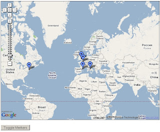
Brighti Solutions - GeoData to GeoRSS

Get your data unlocked and web ready. It's quick and clever
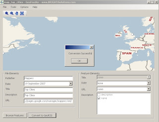
Brighti Solutions GeoRSS Output
At first glance locations seems displaced. But in the Google map (below) locations are in the correct location.

"Yet the problem remains that most geodata is locked away in formats that don't play nice with the major web mapping providers"

"That’s where BRIGHTi GeoFeeder comes to the rescue"

  • Convert to all variations of GeoRSS formats including RSS, ATOM and Simple,GML,
  • Works with the following formats/extensions: .kml, .kmz, .gml, .shp, .mif, .dxf
  • Convert vector data (points, lines and polygons) to GeoRSS
  • Map feature attributes to GeoRSS attributes
  • Specify multiple attributes for elements
  • Displays all features on a Virtual Earth map
  • Browse features and attributes
  • Zoom and pan
Brighti Solutions GeoRSS Google Map
This map took 30 seconds to create - code from the official example
http://www.google.com/apis/maps/documentation/
examples/geoxml-rss.html
*change api key to your website
*change url of the georss.xml (GeoRSS file)
done!
Nice work.

Suggestions
More formats please
hyperlinking urls (like to products - this can be done if edit the xml file)
feedback forum to share issues and solutions

Labels: , , , , , , , ,

10 August 2007

Yahoo Pipes - News Map - Output KML

Yahoo Pipes - News Map
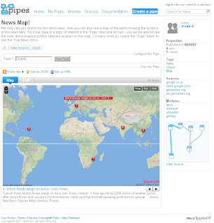
Finally a Yahoo Pipe that uses a map to visualize the found results.

Yahoo Pipe Map - Author Vivek C

Author of the Pipe is Vivek C

Though there were not many feeds to the Map - The useful thing with Yahoo Pipes is that when it is published it is available to public and 'Copies of' can be created (sign in to yahoo required).

Here is Mapperz version of this
Yahoo Pipe Map Mapperz Version
This Map is overlaying rss feed from the yahoo pipe model below
Yahoo Pipe Map Model - Mapperz Version

Add RSS feeds is very easy to apply - use the + icon on the url feed.
Mapperz added some extra rss feeds
BBC News
Reuters UK
Sky News
CNN
and the Mapperz Blog


But the clever thing about this pipe is that it is using a normal rss feed then using geonames.org to apply a latitude and longitude to the rss feed > therefore creating a georss feed. This is then overlayed on a yahoo map showing the locations around the world.

Yahoo Pipe Map KML - Google Earth
One final point, you can export the results to KML and view in 3D using Google Earth.
One helpful scenario would be if you were looking for a new house and you can request different estate agents and overlay and view the surrounding area.

Labels: , , , , , ,

11 April 2007

BlueGhost Integrates GeoRSS Maps

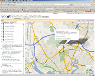
The BlueGhost Project nows uses Google Maps Enhancements to provide up to the minute Travel Incidents across the UK.
BlueGhost GeoRSS and Google Maps

Live Feed Link
http://maps.google.co.uk/maps?q=
http://bbc.blueghost.co.uk/travel_data/locations.rss

Clicking on the blueghost.co.uk inside the icon info window will link to a new map of just that selected area.

BlueGhost GeoRSS Southampton and Google Maps

Markers Represent there is a Incident and the Lines Represent the Road is Closed.

This works very well with live data and shows the full potential of GeoRSS feeds - providing users with up-to-date information.

Well Done to Michael Pritchard (Blueghost creator) for creating this and other very useful data feeds that are displayed in map form.

Other Blueghost maps
http://bbc.blueghost.co.uk/site4.php
(Traffic, Rail and Weather on Google Map - with nice icons)

Labels: , , , ,

27 January 2007

RSS Feeds to GeoRSS Maps

RSS Feeds to GeoRSS
GeoRSS Blog Feed Mapperz Google Map
RSS?
GeoRSS?
Give your posts the spatial location element with http://exploreourpla.net/
converts your rss/atom feeds into maps in seconds.

RSS to GeoRSS Mapperz Blog Feed

To add your rss feed simply go to
http://exploreourpla.net/georss +url of RSS feed in full

Example
http://exploreourpla.net/georss/http://mapperz.blogspot.com/rss.xml
http://exploreourpla.net/georss/http://mapperz.blogspot.com/atom.xml

More info
Source:geonames.org
Related:addressfix.com

Mapperz

Labels: , , , , , ,

01 November 2006

Map 24 Supports GeoRSS Feeds

Map 24 now supports GeoRSS feeds
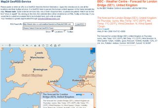
Map24 GeoRSS Feeds

"GeoRSS in general is a technology for distributing news feeds with corresponding location attributes among a great variety of clients. Geographically encoded news feeds may be organized thematically in channels and visualized in web mapping solutions like Map24 Portal. Since GeoRSS is evaluated by the Open Geospatial Consortium (OGC), it is a prospective standard in the geospatial domain."

A large amount of Weather GeoRSS feeds are now available from the BBC Weather Service.
search a region or enter a city (any large city in the world will have a feed)
copy the link (.xml) from clicking the
Weather RSS Feeds View Feed for this Location
http://feeds.bbc.co.uk/weather/feeds/rss/5day/id/3366.xml (London Bridge, UK)
paste into the Maps24 demo.

Labels: , , , ,