->

28 October 2010

Bing Maps The Route Savvy App

Bing Maps The Route Savvy App

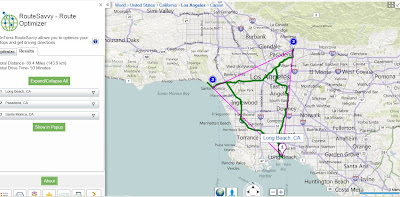
Whether you are going five or fifty places, the Route Planner app is a useful, unique map app that will get you from point A to Z in the shortest amount of time possible.Route Savvy App  Bing Maps

Find Shortest Routes or quickest routes with traffic and managing geocoding from Excel data.

How it Works

Route Savvy App Geocode - Bing Maps

The first step is to add destinations on the map. “RouteSavvy” makes it easy to quickly add a few or 100 destinations – you can click locations on the map, enter addresses manually on the left-rail, or upload an Excel file with addresses on each row. For demonstration purposes, I’ve shown eight points below. Each time you add a destination, the map auto-zooms and centres so you can see all the destinations at once.

Route Savvy App Import Excel - Bing Maps

"General users likely have between three and ten destinations when they plan trips that could benefit from route optimization. The value of this tool for business use is amplified when businesses may have 25 or more destinations to reach in a day. Other servicesonly allow up to 25 waypointsconsidering the Bing app can handle up to 100, we feel that we’ll be a strong choice for businesses who need great route optimization for lots of destinations. Realtor's who have multiple showings in a day, any business that does deliveries, shuttle services, technicians, and florists – just a few examples - will find this to be a great tool to make their lives easier with the “RouteSavvy” app."

View the new Map App: OnTerra’s “RouteSavvy” Route Optimizer


Source(cross posted): Bing Maps Watch

Labels: , , , ,

23 August 2010

Spatial Data Viewer on Bing Maps App

Spatial Data Viewer on Bing Maps App

View
  • ESRI Shapefiles (.shp & .dbf files) [best under 300k]
  • GeoRSS Feeds (.xml with lat & lng)
  • Well Know Text (WKT)
Known as Ricky's Data Viewer
Bing Maps Shapefile Viewer
Loaded Shapefile (World Countries) in the Data Viewer using 'select shapefile' option, .dbf if your want to see attributes (table data).

Bing Maps Viewing GeoRSS Feeds
GeoRSS (.xml) recent earthquakes feed from (USGS)

Full list of Bing Maps Apps.

Labels: , , , , ,

20 January 2010

Bing Maps Destination Maps (Map App)

Bing Destination Maps (Map App)

Bing Destination Maps Apps save styles
Bing Maps Destination Maps (Map App) European Map Style.

Bing Map Explorer moved out of beta today, and some new experimental 'Map Apps' have appeared in a continuing effort to make Bing Maps more widley used.

Bing Destination Maps Apps
The Maps are customised by dragging the edges of the rectangle.

Maps Apps are extension tools to Bing Maps they are only accessible in the sliverlight version.
A good link to observe this tools is
http://www.bing.com/community/blogs/maps/archive/2009/12/21/bing-maps-application-gallery-overview-new-apps.aspx

Desination Maps, now this is very new, though basic Map Types 'American' 'European', Sketchy (Pencil) and Treasure Maps Styles.


This App does have great potential if:
Legend can be added
Annotation/Text can be (Title, Comments)
Simple Arrows, Line,point polygons can be added.
Simple layer contol - move minor roads above major roads.

Destination Map Format Export JPEG
Basic Map - though the Destination Map App has good potential if it has a few more customising tools.

Sharing can be improved by allowing users to specify the size and currently only jpeg and pdf formats are available for export.

Will the Bing/Microsoft Research team work on this?

Current coverage:
  • USA
  • Canada
  • Mexico
Source:
http://www.bing.com/community/blogs/maps/archive/2010/01/19/new-bing-maps-application-destination-maps.aspx

Labels: , , , , , , ,

03 December 2009

BING Maps Explore (Streetside)

BING Maps Explore (Streetside)
*Sliverlight required & in beta
**Streetside mode is in some USA Cities only currently

BING Maps Explore Streetside
Looks familiar to Google StreetView but is a light blue indicating 'StreetSide' coverage.

BING Maps Explore Streetside - Streetside Mode
Streetside mode - has similar features to streetview, controls are slightly different.

BING Maps Explore Map Apps
Apps for your BING Maps - Nearby App (useful), Traffic, Twitter App displays geo-tweets, many more to explore.

BING MAPS BETA NEARBY CLUSTER MARKERS
Nearby Map App- Markers(Icons) group in clusters when there is not enough space to display all markers at zoom levels.

BING MAPS BETA STREETSIDE
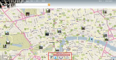
BING Maps Explore has new controls - automatic 'finds' the best map mode for your zoom level

try it
http://www.bing.com/maps/explore/

warning to firefox users - can cause memory leaks and freeze up your browser.

source:
http://www.bing.com/community/blogs/maps/archive/2009/12/02/bing-maps-adds-streetside-enhanced-bird-s-eye-photosynth-and-more.aspx

Labels: , , , , , ,

08 September 2009

Ovi SDK - Map Beta Examples - First Look

Ovi SDK - Map Beta Examples - First Look

It is nearly a week since the public release of the Ovi [Nokia] SDK

Mapping Wise what can you do with it?

Ovi Map Example Apps
Well the first version had an issue - apps would not show, but this has been rectified and now the examples will show in the Nokia(N97) Emulator.

This example shows a few options.
Drop Pin
POI Icons
Server Icon (Wifi/3G connection required)
Local (Phone memory in the app)
Polyline (now we are getting somewhere)
Polygons - Reviewed
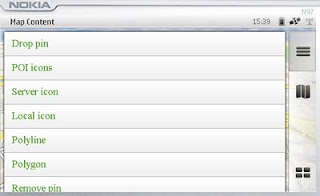
Map Content Example
Landscape mode enabled - shows all example with out needing to scroll.

Polygon Example

mapperz wasn't happy with the example polygon - it didn't seem that helpful

Ovi Maps Beta Example Polygon Bristol,UK
Custom Polygon generated in Ovi Map Player using the Ovi Apps SDK
(mapperz customised the orginal example with something slightly better)
So how was this achieved?

Well you can study the Development Guide or the API Library that comes zipped up
However the fastest way to learn is working examples

The code was found in mapfunctions.js
(in the Downloaded SDK >com.nokia.maps.examples.mapContent)
in here there is a section of code:

Example – Adding a Polygon to the Map
*/
function addPolygon()
{
var polygon = {
type: "polygon",
points:
[{latitude: 51.45128846597743, longitude: -2.5956809520721436}, {latitude: 51.45115474591054, longitude: -2.5934386253356934}, {latitude: 51.44976403399727, longitude: -2.5936853885650635}, {latitude: 51.449957933872724, longitude: -2.595916986465454}],
visible: true,
width: 5,
color: {red: 180, blue: 20, green: 0, alpha: 255},
fillColor: {red: 0, blue: 0, green: 0, alpha: 100}
};
// Set zoom level
player.map.setZoomScale(500);

// Move map center to a central location between the three points of the polygon:
player.map.moveTo({
latitude: 51.45052625634988,
longitude: -2.5947046279907227
});

// Create a layer:
//var layer = player.map.createLayer({name: "testLayer1"});

// Add the polygon:
var mapObjects1 = layer.addMapObjects(polygon);

}


all that code for one square polygon? well yes...

Now in real-world terms you need quite a lot of information before you start:
Coordinates for each vertices is required to have
{latitude: 51.45128846597743, longitude: -2.5956809520721436}
easier would be: {lat1:
51.451288,lng:-2.595680}
but it would be simpler to list them in a clockwise order.
or you end up copying and pasting lots of coordinates for quite simple shapes.

**note make sure you use {} 'curly brackets' and not () 'normal brackets' or you will get javascript errors.

There is currently no option for holes in polygons (donut polygons)
What would really help is the ability to overlay KML/GPX files from servers or accessed from the device.

Not sure why zoom extent coordinates are required - would be easier for the extent of the polygon(s) to be used.

Less code makes faster devices (http://www.bewebmaster.com/42.php)
color: {red: 180, blue: 20, green: 0, alpha: 255},
fillColor: {red: 0, blue: 0, green: 0, alpha: 100}

how about:
rgb:180,20,0,255
fill:0,0,0,100


Was hoping to evaulate the New Ovi Maps Navigiation API though in reading the documentation you get a message:

NOTE: The functionality described here is not yet available.

Would prefer they left it out until it was available - would presume that this requires an api key of sorts - but if wanted it tested and de-bugged in beta you would think it would be.


There is demand for this - many, many mobile devices are geo-aware and can use this but it seems clearer there is going to be a good few months of re-writting code to make this a truely customisatable portable mapping and navigational system.
Mapperz will review when activated.

The SDK has been written by techinical people and it does show. They say you are required some basic knowledge of html & javascript.
Mapperz would say you are required to be at an intermediate level for javascript, html,css and de-bugging.
Note: The Software Aptana 1.5 is required to do serious work in the Ovi Apps SDK.

Nokia have the resources they just need to apply it a little stronger.
Web Documentation would be also helpful - like many other mapping apis available.

So the answer to their blog
"OviSDK+you=Ovi Apps for Everyone"
http://blog.ovi.com/2009/09/03/ovi-sdk-you-ovi-apps-for-everyone/?utm_source=rss&utm_medium=rss&utm_campaign=ovi-sdk-you-ovi-apps-for-everyone

is no currently and unfortunately (hope this changes)

Action please
Nokia need people with basic programming - to read their documentation and highlight areas of explanation.

Ovi Maps Player API stongest competitor is going to be Google Map API (v3) There are some interesting features coming to it in the coming weeks, stay tuned.

When these teething issues have been ironed out then they will have a competitive product.
There is no indication whether the Navigation API will require a licence.
Currently Nokia Ovi Map users require a daily,weekly,monthly or yearly licence to use Navigational Features, if you make an app with it - does everyone require a seperate licence.
If they do it will be a stumbling block for a promising feature.

Labels: , , , , , , , ,

08 June 2009

Scoot Maps and Filters

Scoot Maps and Filters

Scoot Maps
Find many things fast using the scoot database and overlay it on google maps

http://tinyurl.com/scoot-maps

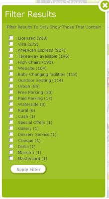
The unique feature here is in the filter options: Even the option to filter by payment.

Scoot Maps Filter

iPhone users will be happy to know there is a Free iphone app created by scoot.
http://www.scoot.co.uk/about-us/scoot-iphone-app.html
(maps and directions available) hopefully more mobile devices will be available in the near future.

Labels: , , , , , ,

05 September 2007

N95 Free Mobile Software (including Maps)

New N95 Free Mobile Software (including Maps)

reLive! Map London Demo

Nokia Download!
New
"Download! for PC enables you to discover mobile content using a PC. When you connect your mobile device to the PC, Download! for PC automatically synchronises with the corresponding software on your device. This makes it easy for you to find, download and manage content (maps) that is compatible with your device."
http://www.nokia.com/betalabs

Opera Mini 4 Beta v2
http://www.operamini.com/beta/
A Good Mobile Browser that allows you to view web based mapping now in landscape mode.

amAze 4.0
http://www.amazegps.com/index.php?page=countries&language=uk
The best Free Sat Nav For GPS enabled phones (includes N95)

Mosh Nokia New!
http://mosh.nokia.com/
"Your Stuff. Any Phone. Everywhere."
A good resource for finding and sharing Apps, Software,Music, Maps, Games, Pictures, Ringtones etc.

Local Search (Yell and Yahoo Search integrated with Map Option with results)
http://mobilesearch.nokia.com/A4160040


Mapperz Top Pick
reLive!
a unique and handy leisure application, allows you to take photos and write notes along your trip route, and seamlessly attach them to their locations on the map (geo-tagging).

reLive! Map

Demo ( in Flash)
http://relive.atlasct.com/map.asp
Download reLive! at
http://relive.atlasct.com/wap/ (via your mobile)

more info at
http://www.atlasct.com/Applications-ReLive.html

Labels: , , , , , , ,