->

28 October 2009

Google Navigation Beta for Andriod

Google Navigation Beta for Andriod
(turn-by-turn GPS navigation with voice guidance for the Google Android Platform)

News update: 29/10/2009
"Shares in sat-nav device companies have fallen substantially after Google unveiled its free live sat-nav for mobiles on Wednesday.

US firm Garmin fell 18% after details of Google Maps Navigation were revealed. Dutch firm TomTom fell 9.5% when markets closed on Thursday."

http://news.bbc.co.uk/1/hi/business/8331824.stm

Google Maps Navigation is an internet-connected GPS navigation system with voice guidance. It is part of Google Maps for mobile and is available for phones with Android 2.0.

Google Navigation - search along a route
Searching for Points of Interest along your route. (users choose poi topics)

Google Maps Navigation uses your phone's internet connection to give you the latest maps and business data. But that's not all that's different about Google's approach to GPS navigation. Watch the below video to learn more.

1. Search in plain English
2. Search by Voice
3. Traffic View (see busy routes either green,yellow,red segments)
4. Search along a Route (Points of Interest of users choice along the active route)
5. Satellite View (includes direction visualisations)
6. Street View (includes direction visualisations)
7. Car Dock Mode - Landscape. (voice processing active, backlight enabled)

http://www.google.com/mobile/navigation/index.html#p=default


source:
http://googleblog.blogspot.com/2009/10/announcing-google-maps-navigation-for.html

Labels: , , , , ,

05 September 2007

N95 Free Mobile Software (including Maps)

New N95 Free Mobile Software (including Maps)

reLive! Map London Demo

Nokia Download!
New
"Download! for PC enables you to discover mobile content using a PC. When you connect your mobile device to the PC, Download! for PC automatically synchronises with the corresponding software on your device. This makes it easy for you to find, download and manage content (maps) that is compatible with your device."
http://www.nokia.com/betalabs

Opera Mini 4 Beta v2
http://www.operamini.com/beta/
A Good Mobile Browser that allows you to view web based mapping now in landscape mode.

amAze 4.0
http://www.amazegps.com/index.php?page=countries&language=uk
The best Free Sat Nav For GPS enabled phones (includes N95)

Mosh Nokia New!
http://mosh.nokia.com/
"Your Stuff. Any Phone. Everywhere."
A good resource for finding and sharing Apps, Software,Music, Maps, Games, Pictures, Ringtones etc.

Local Search (Yell and Yahoo Search integrated with Map Option with results)
http://mobilesearch.nokia.com/A4160040


Mapperz Top Pick
reLive!
a unique and handy leisure application, allows you to take photos and write notes along your trip route, and seamlessly attach them to their locations on the map (geo-tagging).

reLive! Map

Demo ( in Flash)
http://relive.atlasct.com/map.asp
Download reLive! at
http://relive.atlasct.com/wap/ (via your mobile)

more info at
http://www.atlasct.com/Applications-ReLive.html

Labels: , , , , , , ,

23 August 2007

SatMap - A Sports GPS

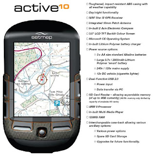
SatMap - A Sports GPS called the 'active10'

Sat Map Sports GPS

Source: © Satmap Systems Ltd

Specifically built for the UK Market. So it's waterproof!

Contains Ordnance Survey Mapping (on SD Card)

Easy to use
No computer is needed, just insert a map (SD Card) and go.

Real maps select from the wide range of titles
containing high quality maps supported by Ordnance Survey.
1:50,000 and 1:25,000 Mapping

Clear navigation
The intelligence of the active10 makes finding your way simple.SatMap Sports GPS Features

Source: © Satmap Systems Ltd

Internet links
A simple USB cable is all you need to connect to the Internet to download maps or share your favourite routes.

18 different titles, each one giving you all the 1:25,000 EXPLORER and 1:50,000 LANDRANGER maps on the trail making sure you stay on track.

UK Regions
10 different titles, each showing over 20,000 km2 of the country on a 1:50,000
LANDRANGER map giving you the freedom to roam throughout your region.

UK Counties
67 different titles, each on a 1:50,000 LANDRANGER map, allowing you to
focus on your favourite county.

Electronic compass
An internal electronic compass that works just like a standard hand-held compass.

Trip statistics
Automatically records route data so you always know how you are doing.

Price £300

Looks good and sounds great but a few questions

Does is export to KML?
Battery life?
Can you add your own mapping?
If you don't need PC how do you connect to the internet to share maps? (Built in Wifi?)

Technical Specs (PDF)
http://www.satmap.com/eshot/Satmap_product.pdf

http://www.satmap.com/eshot/Satmap_Tech_Spec.pdf

Labels: , , , , , ,

11 November 2006

Sat Nav loses to Road Atlas

Interesting to see the outcome of this test.

Garmin Sat Nav LosesAA Great Road Atlas 2007 Winner
Four users were to Navigate through London:

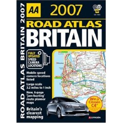
One was given an AA's Great Road Atlas 2007
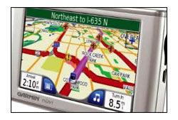
Another used the satellite navigation system (a Garmin unit)
The third was supplied with a printed map using Microsoft Autoroute 2006
The four participant made use of the Government's free Transport Direct website.


Results were surprising.

1st in 1 hour and 35 minutes for the AA's Great Road Atlas 2007.
2nd 1 hour and 43 minutes for the Garmin Sat Nav.

3rd 1 hour 49 minutes for the printed Autoroute map.
4th 1 hour 56 minutes for the Transport Direct map.

Question
but why?

Answer
It is true technology guides and helps us all in performing tasks.

However it is the way the information is communicated to the user.
So in this case the Cartography wins this task by providing the user with clear instructions that can be applied in the real world.

Until 'Sat Nav' companies use cartographers to help them present the data and have cartographic editors to verify and double check the source data is correct the hardcopy map will win.


Look out for the New AA 1:100,000 (currently 1:200,000)
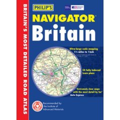
Road Atlas going to print soon, this goes head to head with the Philips Scale of Road Altas.

Philips Navigator Road Atlas

Labels: , , , , ,