->

30 September 2010

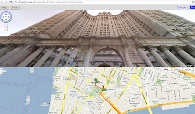
TripGeo - Directions with Video Streetview

TripGeo - Directions with Video Streetview

"If you need a directions widget for your business, school or college you could do a lot worse than embed a free Directions Map widget on your website. TripGeo Directions uses Google Maps to help users create an embedable driving directions map for their website or blog.

TripGeo - Directions with Video Streetview  NYC

The really fun part of this Google Maps based widget however is that it also allows you to create animated Street View tours. If you just add a starting point and a destination to Directions Map you can then view the route entirely in Street View.

Directions Map allows users to create driving directions from any starting point to any location. Users can also define the height, width and the map type of their widget. Once the widget has been embedded on a website it can then be used to follow the given driving directions or to view an animated walk-through of the route in Street View.

The animated walk-throughs of routes with Street View are very impressive. Given the impressive nature of these Street View animated routes I can see Directions Map also being used by websites to create virtual tours. In fact Directions Map has created a number of example animated Street View routes for locations around the world."
TripGeo - Directions with Video Streetview
Glide along with directions and video streeview (click play).
Here are links to some of the example animated Street View routes:

Chapmans Peak Drive, South Africa
Chateau d'Eox , Switzerland
Golden Gate Bridge
Colosseum, Rome
Las Vegas Boulevard
London, from the Houses of Parliament to the British Museum

Because Directions Map uses dynamic URL's you can even play about with the web address to quickly create your own routes by changing the start point and destination in the URL.

Here is the URL for New York to Boston:

http://s3.tripgeo.com/dirmap/map.htm?from=New%20York&to=Boston


If you want to view a Street View animation of the route from New York to San Francisco just change 'Boston' to 'San Francisco in the URL above. So what routes can you create. Post links to your routes in the comments below.

Update: microformats.dk has quickly created a page combining a Directions Map Street View tour of the Alpe d' Huez with a Kraftwerk YouTube video. Superb!

cross-posted from Google Maps Mania

Labels: , , , , ,

24 September 2010

GeoVation Challenge

GeoVation Challenge

This year, GeoVation has been split into three separately themed challenges, the first of which was ‘How Can Britain Feed Itself?’ now closed to new entries, although you can still visit the site to read and rate the 52 ideas that have been contributed.

But fear not, the chance to be involved has not passed you by; for the next Challenge is due to open on Tuesday 28th September 2010 and is entirely focused on how geographic data can help us get from A to B.

Bumper to bumper. Photo by Lynac via Flikr

Bumper to bumper. Photo by Lynac via Flikr

There are huge and exciting opportunities for geography to be harnessed to solve transport related problems, especially with the influx of open data releases that we’ve seen over the past months. Those include Data.gov.uk; Ordnance Survey’s own OS OpenData portal; a number of local authorities; and most recently transport data from Transport for London.

And, for the second of this year’s Challenges, delighted to have the additional support of the the TSB funded Ideas in Transit project and the National Business Travel Network.

Ideas in Transit is a five-year project that applies “bottom-up” innovation to the transport challenges faced by individuals and society. NBTN promotes workplace travel planning as a cost effective way for businesses to reduce CO2 emissions and benefit staff.

Both are committed to supporting a sustainable future for transport in Britain and with their help we’re really hoping that we’ll uncover something extra special.

GeoVation

We are all users of transport, so if you’ve got a geography based transport idea why not submit it next week? The best entries will be invited to a further develop their ideas at a GeoVation Camp before going on to pitch for funding at a ‘Dragons’ Den’ style showcase next year.

There is a prize fund of £25,000 available to award to winning ideas and whilst entrants aren’t limited to using Ordnance Survey data, there is also an additional prize available for the best use of any of the datasets freely available through OS OpenData.

Keep an eye on GeoVation.org.uk next week for more details on the second challenge and you can also follow the project on Twitter for all the latest news at @GeoVation.

Reposted by request (twitter) from:

http://blog.ordnancesurvey.co.uk/2010/09/geovation-seeks-ideas-to-get-you-moving/

Labels: , , , ,

21 September 2010

Transparency Report: Government Requests Map

Transparency Report: Government Requests Map

"We’ve created an interactive map of Government Requests that shows the number of government inquiries for information about users and requests for Google to take down or censor content. We hope this step toward greater transparency will help in ongoing discussions about the appropriate scope and authority of government requests."
Government Requests Map

United Kingdom
In the UK for example, the map shows that there were 1,343 requests for data between January and June 2010. There were also 48 requests for the removal of content, regarding 232 items. The majority of this content was within the web search category.

Transparency Report: Traffic Chart
http://www.google.com/transparencyreport/traffic/


Transparency Report: Traffic Map
http://www.google.com/transparencyreport/governmentrequests/

Labels: , , , ,

20 September 2010

Hurricane IGOR - NOAA KMZ Overlays

Hurricane IGOR - NOAA KMZ Overlays

Hurricane IGOR Advisory Archive NOAA KML/KMZ - National Weather Service
Hurricane IGOR Advisory Archive NOAA - National Weather Service - KMZ Display using Google Maps v3.

Overlayed 4 KML/KMZ files from
http://www.nhc.noaa.gov/gis/archive_forecast_results.php?id=al112010&name=Hurricane%20IGOR

Mapped the overlays here
http://mapperz.110mb.com/GMAP/Hurricane_Igor.html

Labels: , , , , , ,

17 September 2010

Twitter: Tweet With Your Location

Twitter: Tweet With Your Location
(This additional service is now being rolled out across the world)

Twitter's Tweet With Your Location feature allows you to selectively add location information to your Tweets. This feature is off by default and you will need to opt-in to use it. You can find out how to start using this feature on the How to Tweet With Your Location help page; this article is an overview of the feature.Mapperz Twitter Tweet Location Map

Once you've opted-in, you will be able to add your location information to individual Tweets as you compose them on Twitter.com and with other applications or mobile devices that support this feature. The location information that is shared publicly can be either your exact location (your coordinates) or your place (like a neighborhood or town).

Tweeting with your place or coordinates can add context to your updates and help you join the local conversation, wherever you are.

Helpful links for Your Questions:

How do I tweet with my location?

http://support.twitter.com/articles/122236

http://support.twitter.com/articles/78525-about-the-tweet-with-your-location-feature


This service was first introduced in November 2009 [USA only] via the twitter api, now this is available in users settings (off by default).

Most likey because FaceBook Places has been rolled out globally too.
http://www.bbc.co.uk/news/technology-11342802

Labels: , , , , ,

13 September 2010

World War Two: Battle of Britain Maps

World War Two: Battle of Britain Maps

"
MSN has teamed up with Shoothill to present an interactive overview of the Battle of Britain. Zoom into a mosaic of archive images and documents; compare present-day maps with maps and charts showing bomb damage during the Blitz; and view high-resolution Photosynths of iconic RAF aircraft."

This is one of the 'Best Bing Interactive Maps' for 2010 (and 1940)


World War Two: Battle of Britain Maps

The TimeMap is based on Bing Maps Silverlight Control. It shows original maps, reconnaissance imagery and target documents of the German Luftwaffe. You can navigate to various locations through quick links in a target list for London and Coventry.
  • The TimeScope can be dragged around to explore the location
  • The TimeSlider lets you switch between various historic maps and satellite imagery and the Documents.
  • DeepZoom - Compositions of the original target documents within the TimeScope.

Click for large view on the Map Controls, TimeSlider and TimeScope.

View the maps here:
http://news.uk.msn.com/in-depth/world-war-two/battle-of-britain/default.aspx

Labels: , , , , , , ,

09 September 2010

Points of Control Map

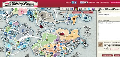
Points of Control Map - The Battle for the Network Economy

Points of Control Map
Social Networks and industry leaders battle it out over this 'Points of Control' Map. You can add your own comments and link up with social networking. Then see the map grow over the coming weeks.

Build the Map...

"In the coming weeks, we plan to add a game of sorts – we’ll be asking you to lay out which companies the incumbents should be buying as they circle each other across this landscape. From the tiny to the massive, we’d like to see who you think will be snatched up next.

For now, we know that we have certainly missed things – probably a lot of things. And no doubt our initial choices of players, and the amount of territory they control, is worthy of debate (as is, most likely, our sense of humor). That’s why we want your input. We’ve created a commenting layer throughout the map, and we will be incorporating your input into future revisions. We’re not happy with the name for the Location Based Services territory, for example, and we’re still trying to figure out how to deal with the carriers (who isn’t!?)."

More than any time in the history of the Web, incumbents in the network economy are consolidating their power and staking new claims to key points of control.

Meanwhile, insurgents both large and small are hoping to gain footholds or take ground in new territories.

Map control

As simple as using the Google Map, plus add your own content, and help make the map grow.

Pan and Zoom to explore the map, and click the icons to get some insight about each player and their position.

Then, turn on the comments view to discuss the map with others and add your own ideas!

Also, bring the conversation to Twitter using hashtag #w2smap. We'll be listening!

http://map.web2summit.com/

Source:

http://blog.web2summit.com/2010/08/29/points-of-control-the-map/

Labels: , , , ,

07 September 2010

50 Best Blogs for Geography Geeks

Geography appeals to a wide audience due to the fact that it both influences and is influenced by a staggering number of subjects. History, politics, earth sciences, anthropology, archaeology, social sciences, technology and myriad other disciplines all contribute to geography as a cohesive whole. Unsurprisingly, the internet overflows with blogs that analyze the topic and its close relationship with every other discipline imaginable. Readers pining to learn everything they can have plenty of free, wonderfully diverse resources available to quell their thirst for information. Peruse everything they have to offer – and don’t forget to check out the contributions of other blogs who sadly did not end up on this list, likely due to a slower update schedule. Just because they didn’t end up here doesn’t mean that they don’t have anything valuable to offer!


"Online Engineering Degree is an nonprofit online resource created to explain to students their options and some of the advantages and disadvantages of getting an online engineering degree. It was our opinion that existing sites which attempted to explain to students the reality of obtaining your engineering degree online were typically for-profit and thus biased and less trustworthy.

This website is owned and maintained by Edgar Diaz and Samantha Rhodes, engineering professionals who both obtained their engineering degrees online. While we both have day jobs, we each make significant time for this website and for answering student emails each week, so if you have any comments or questions, please see http://www.onlineengineeringdegree.org"

Full List of the Best 50 Blogs:

1 National Geographic Blog Central

Explore the world through one of the essential resources on the subject of all things geographic – from cartography to culture, everything gets covered by National Geographic.

2 Matt’s Geography Blog

About.com’s Geography Portal, hosted by Matt Rosenberg, writes about a nice, broad range of relevant topics suitable for general audiences.

3 Newgeography.com

Geography extends beyond the cartographic, as this fantastic must-bookmark illustrates with its excellent writings on the people who make up the places.

4 The Urbanophile

Fans of geography interested in the specifics of cities will love crawling through Aaron M. Renn’s musings on urban areas throughout the world.

5 The Rural Blog

On the other side of the geographic coin lay The Rural Blog, where readers can trace the trends and ideas that shape those particular corners of the United States.

6 Cultural Geography Blog

Watch as people, cities and movements ebb and flow throughout the world with this very cool, very informative blog.

7 Geographic Travels

From the straight-laced to the esoteric, Geographic Travels has plenty of great maps and images to illustrate the true diversity of the discipline.

8 Making Maps: DIY Cartography

Geography buffs who enjoy drawing up their own maps of natural landmarks, cultural phenomena and more will love learning the latest ideas and strategies. A year went by without updates, but they seem to be back into the groove of things.

9 Free Geography Tools

Independent mappers in search of a few gratis technologies to indulge their passion need to bookmark Free Geography Tools and follow the latest and greatest developments.

10 Google Earth

Even those without an overwhelming geekiness towards geography still love tooling around with Google Earth…and those that do probably enjoy following what’s going down with the application.

11 Ogle Earth

Stefan Geens analyzes how “Google Earth and other neogeographical tools” come to impact the perceptions of professionals, amateurs and hobbyists alike.

12 All Points Blog

The official blog of Directions Media, All Points Blog posts about geography as it relates to politics, economics and other subjects.

13 Mapperz

Follow Mapperz for news and reviews of online mapping and GIS programs, discovering the best ones to suit certain needs.

14 Slashgeo

This community and accompanying blog serves as an excellent online forum for geography geeks to band together and discuss their love of geospatial technology – and more!

15 The Map Room

Jonathan Crowe writes about all the ins and outs of maps and mapping technologies in a manner that general audiences can understand.

16 Digital Urban

Digital Urban wants its followers to learn everything they can about the development of cities – their architecture, culture, politics, economics and (obviously) geography.

17 Strange Maps

Cartography lovers interested in perusing the weird and wonderful corners of their hobby (or profession!) need to drop by Strange Maps for some educational fun.

18 Geography blog from Networlddirectory

Most of the content available through Net World Directory’s Geography blog tends to emphasize the environmental facets of the discipline.

19 Google LatLong

The developers behind both Google Maps and Google Earth band together to offer an excellent resource for geography aficionados who enjoy reading about their hobby with a generous shot of technology.

20 Edible Geography

This absolutely amazing blog discusses geography through a foodie’s filter, facilitating talks about how the 2 fields have come to greatly impact one another.

21 World Geography Blog

Read World Geography Blog for global news and views about the immensely intimate relationship between people and places.

22 Bing Maps Blog

Fans of what Bing Maps has to offer may want to keep up with what the developers have been doing to make it the best application it can possible be.

23 Maponics Blog

The GIS service Maponics blogs about its latest endeavors and what they can provide the geography community.

24 AnyGeo

Anything and everything of interest to geospatial technology fanatics can be found right here at this incredibly popular and informative blog.

25 My Wonderful World Blog

National Geographic and other related institutions and publications band together to promote relevant educational initiatives in order to narrow the gulfs between different peoples.

26 Virtual Earth/Live Maps

Dive into the most fascinating corners of current geospatial technologies with one of the most in-depth online resources on the topic.

27 VerySpatial

Between the blog, videos and podcast, VerySpatial has plenty to please fans of all things geography – though mainly emphasizing the latest news and views regarding geospatial technology.

28 Students Without Borders

World University Service of Canada hopes to bring together students from all over the planet as a means of broadening horizons and strengthening understanding between vastly different cultures.

29 James Fee GIS Blog

WeoGeo’s James Fee keeps his readers updated on the diverse news and views from across the rapidly growing GIS industry.

30 Interchange

Planetizen’s Interchange blog caters to geography geeks curious about urban development and the various issues that come with it.

31 Google Maps Mania

These ardent fans of Google Maps hope to share their love of pushing the application to its fullest potential with fellow geography and geospatial technology buffs.

32 Terrain.org Blog

Ruminations on landscapes both natural and constructed comprise the content of Terrain.org and its associated blog.

33 Computing, GIS and Archaeology in the UK

Archaeology and GIS technologies collide in one incredibly interesting resource that focuses mainly on goings-on in the United Kingdom.

34 Google Sightseeing

Google Sightseeing is not affiliated with the eponymous corporation, but it does showcase a love of their applications by using it to take viewers on digital tours around the world.

35 knowwhere

Steven Feldman loves himself some geography, keeping an excellent blog that concentrates on how GIS technologies have forever changed the way people perceive the world around them.

36 Asia Ruminations

China-based Fulbright fellow Daniel Michaeli may not update as often as other bloggers on this list, but his blog remains a must-read for anyone fascinated by Asian geopolitics.

37 Spotlight on Geopolitics

In both English and Italian, Florian Pantazi writes about the geopolitical climate of the European Union.

38 Planet Geospatial

A rotating band of contributors aggregate the best of the best geospatial postings from around the internet.

39 GeoData Policy

Stop by GeoData Policy for detailed news on geospatial technology, geopolitics and social issues and impacts.

40 European Geostrategy

Geography geeks who enjoy studying European geopolitics and defense strategies may find this blog an incredibly engaging resource.

41 Adam Estrada

Geospatial professional Adam Estrada uses his blog to share everything he learns about the industry while going about his day-to-day doings.

42 Geofooding

Geography’s impact on food and foodie culture is undeniable (as is the reverse!), and anyone who enjoys both will find this blog a wonderful treat. Be sure to check out the recipes, too!

43 Geographicus

The rich history of geography and cartography comes alive through amazing imagery and detailed writings – anyone wanting to trace the origins of today’s geospatial technologies should stop by the excellent Geographicus immediately.

44 Atlas Obscura

Explore the wacky world continent by continent in search of esoteric, obscure people, places and things that make Earth what it is today.

45 RealClimate

Climate – and all the scientific and political factors surrounding it – has everything to do with geography.

46 geoMusings

Bill Dollins dishes on geography, with particular attention paid to the latest developments and opinions regarding GIS technologies.

47 Discovery News

The Discovery Channel posts up the latest news on the natural world blog-style, covering myriad topics of interest to geography fanatics of all ages and skill levels – including earth sciences, history, anthropology, paleontology and much more.

48 Climate Progress

For geography fans interested in learning more about anything and everything about climate – particularly politics and science – Climate Progress makes for an essential read.

49 Dot Earth

The New York Times’ official blog regarding the environment and natural resources greatly appeals to those who enjoy studying their geography through a green lens.

50 Global Voices

Source:

http://www.onlineengineeringdegree.org/50-best-blogs-for-geography-geeks

Many thanks to Samantha Rhodes from Online Engineering Degree.

Labels: , , ,

01 September 2010

New BBC Travel Maps (Beta)

New BBC Travel Maps (Beta)

New BBC Travel Maps (Beta)
Improved Navigation and live feeds (jamcams included), much better Travel News from the BBC.

http://www.bbc.co.uk/travelbeta/birmingham/

What's new:
  • Updated design, with wider pages and larger text.
  • Improved navigation, allowing movement between adjacent geographic areas
  • Interactive mapping, which can be minimised if you prefer the text incident list
  • Clearer timestamping of incidents.
  • Traffic jam cams showing frequently updated still images of traffic conditions on motorways and trunk roads
Addional Improvements
  • The text incident list has been updated to improve readability, and is synchronised with the map.
  • Local weather forecast from the BBC Weather Centre for the next 6 hours from now
  • Backend improvements to our data-handling system to categorise data, and speed up the reception and delivery of data to the site.

What's not changed:
  • BBC's comprehensive traffic and travel information remains at the core of the service, updated around the clock
  • The text list remains, and you can hide/minimise the map, to put the functionality of the site back to the way it used to be.
  • BBC have made the redesign as subtle as possible, in order to retain the things you've told us you like about the existing site.
  • In the final version of the site, you'll be able to click to see a country-wide motorways or major roads overview from every page.
  • BBC's door-to-door journey planner, powered by Transport Direct, remains but has been made more prominent.

Why a new version of BBC Travel News:

"Firstly, to update the design to take advantage of the BBC's wider page layout, introduce maps across the site for the first time, and make some basic improvements to the presentation of our information
Secondly, to improve the data-handling processes behind the scenes, to allow us to separate the data into more useful groups, and reduce the time it takes for the data to reach you
Thirdly, to integrate traffic jam cameras (where available) into the main BBC Travel News website alongside our incident data"

Current BBC Travel Maps (Beta) Areas:

Birmingham beta
Black Country beta
Coventry beta
Herefordshire beta
Shropshire beta
Staffordshire beta
Warwickshire beta
West Midlands beta
Worcestershire beta
Wolverhampton beta

Labels: , , , ,