->

17 September 2010

Twitter: Tweet With Your Location

Twitter: Tweet With Your Location
(This additional service is now being rolled out across the world)

Twitter's Tweet With Your Location feature allows you to selectively add location information to your Tweets. This feature is off by default and you will need to opt-in to use it. You can find out how to start using this feature on the How to Tweet With Your Location help page; this article is an overview of the feature.Mapperz Twitter Tweet Location Map

Once you've opted-in, you will be able to add your location information to individual Tweets as you compose them on Twitter.com and with other applications or mobile devices that support this feature. The location information that is shared publicly can be either your exact location (your coordinates) or your place (like a neighborhood or town).

Tweeting with your place or coordinates can add context to your updates and help you join the local conversation, wherever you are.

Helpful links for Your Questions:

How do I tweet with my location?

http://support.twitter.com/articles/122236

http://support.twitter.com/articles/78525-about-the-tweet-with-your-location-feature


This service was first introduced in November 2009 [USA only] via the twitter api, now this is available in users settings (off by default).

Most likey because FaceBook Places has been rolled out globally too.
http://www.bbc.co.uk/news/technology-11342802

Labels: , , , , ,

25 February 2010

Google Fusion Maps - February 2010 Update

Google Fusion [Tables] Maps - February 2010 Update - More Powerful

An Interesting update here in a previous blog post
Note: Suggestions, would be nice to be able to overlay the thematic map [based in flash] over the Google Map (or creating gpolygons). Sharing with the option of embedding and link to would be convenient.

Well seems like this service has improved:
How?
  • Some new features that will let you upload and map large amounts of geographic data.
  • You can also now hide and show different data depending on your own criteria.
  • Create Custom HeatMaps with your own data.
  • You Do NOT need to be a Developer.
  • Embed Your Map to your website or blog.
Google LatLong Blog has a great example of the new power (without being a developer)
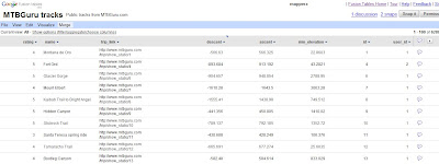
Google Fusion Tables Routes Datasource
Go from the this table of Bike Tracks.. http://tables.googlelabs.com/DataSource?dsrcid=11310

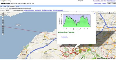
to a nice bike tracks map with routes and altitude on a map with little or no programming.
Google Fusion Tables Routes Mapped

Points are displayed at small scales but zoom in and routes of bike tracks are displayed very fast on the map Note: Goto 'Visualize >Map
http://tables.googlelabs.com/DataSource?dsrcid=132848

http://www.mtbguru.com/ is responsible for this first example using this method, mapperz highly recommends readers to look at the blog post: http://blog.mtbguru.com/2010/02/24/mtbguru-tracks-as-seen-through-google-fusion-tables/
which goes through the motions clearly on how to do this. Then you can try it with your own datasets.

Create Heatmaps
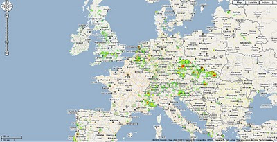
Google Fusion Tables Routes Heatmap
You can even create Heat Maps simply with your own data.

A great way to get started on mapping your own data.

Embed the Map:


(for the coders)

Using iframe
iframe width="500px" height="300px" scrolling="no" src="http://tables.googlelabs.com/embedviz
viz=MAP&q=select%20col0,col1,col2,col3,col4,
col5,col6,col7,col8,col9,col10,col11
%20from%20132848%20where%20col11%20%3E%20'70'&h
=false&lat=49.85392252759648
&lng=14.85626220703125&z=9&l=col10"/iframe

Under the hood:
http://maps.google.com/maps?gwt=1&file=api
&client=google-fusiontables&sensor=false&v=2.x">

var map = new GMap2(document.getElementById("map_canvas"));
map.setCenter(new google.maps.LatLng(49.98,14.88),9);
var l = new GLayer("span style="font-weight: bold;">ft:132848");
<< style="font-weight: bold;">select+col10+from++132848/span"); 
Select column 10 from fusion table ID

map.addOverlay(l);
map.setUIToDefault();
map.addControl(new GMapTypeControl());
map.addControl(new GLargeMapControl());
map.addMapType(G_PHYSICAL_MAP);

Source and More details on http://google-latlong.blogspot.com/2010/02/mapping-your-data-with-google-fusion.html
credit to http://www.mtbguru.com/

Labels: , , , , , ,

10 April 2009

Google Maps Mobile [version 3.0.1.4]

Google Maps Mobile [version 3.0.1.4]

Google Maps Mobile version 3.0.1.4
A minor update but with a few changes.

Most noticable when you search the result animate [drop in markers] to the area.

New Users to Google Maps Mobile can have the following in thier pocket:

Public Transport
Public Transport - can change times starting off.

Send as SMS - Text Message
Meeting a friend? You can send them the map where to meet.

Walking Directions Beta
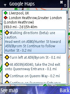
Walking Direction improved - Not really walking Liverpool to London Heatherow but just a good test - seems faster to calculate in prevoius versions.

Street View Mobile with route
StreetView Mobile - again seems much quicker and also displays your route [pegman guides you].

Available via - http://www.google.com/mobile/


Source:
http://www.allaboutsymbian.com/news/item/9286_Google_Maps_for_Symbian_update.php


Labels: , , , , ,

24 March 2009

Nokia SportsTracker v2.05 with Maps

Nokia Sports Tracker v2.05 with Maps

Finally Nokia makes the map option available in the Sports Tracker Application
Nokia Maps v2.05 - With Maps
Image source:
http://nokiae71.wordpress.com/2009/03/23/the-best-now-even-better-nokia-sports-tracker-205/

Phone - Map Options - Source
Maps are available - though the Phone option does not use Nokia Maps (v2 or v3) data to display but rather downloads tiles (similar to web based maps).

Not sure if that is a good thing, Would rather have preloaded tiles on an area - due to out of network issues with walking, hiking, cycling in rural areas.

But at least the maps have made it to this application- after a long and a number of submitted requests.

Only 'Map Tiles' available - no Satellite or Terrain option (unlike the Nokia Maps)

The fastest way to get it is connet to a wifi source and use the 'check for updates on the phone.
Or Download it from here
http://sportstracker.nokia.com/nts/mobile/downloadclient.do?p=50&hw=536926806
(link is a direct link to the file SportsTracker_50_v205.sisx)

Sports Tracker GPS fix quality
GPS Fix strength/quality is viewable (map has no data in this area) and will also replay your routes.

http://betalabs.nokia.com/blog/tag/sports-tracker/

Suggestion - Terrain maps would be useful.

Labels: , , , ,

27 February 2009

Vector Magic - Raster to Vector - update

Vector Magic - Raster to Vector - update

"One of the best products out there that really does vectorize raster images to enable editing/scaling and just makes life easier in the cartographic world."


Vector Magic takes a raster image and recreates it in a vector format.
image sources: Vector Magic


The new version (26th Feb '09) v1.11 (pc) v1.14(mac) has a number of new features including:
  • Now export to AI (Adobe Illustrator), DXF (CAD) (in addition to EPS, SVG, and PDF)
  • On PC, export to Microsoft Office EMF format
  • More export options (group by colour, stroking mode)
  • More compatible EPS output
Get an order in by 6th March for the Desktop Version using the promotion code VMDE0306 before March 6th and get a $50 discount.

Mapperz has seen Vector Magic develop from Stanford University Artificial Intelligence research project into a fully commercial and viable product in less than 2 years. Well done to the creators in making and continuing to develop this excellent product.

Desktop Version
http://vectormagic.com/desktop/

Online Version Available (less functionality)
http://vectormagic.com/online/how_it_works

Source:
http://vectormagic.com/blog/posts


Labels: , , , ,

26 February 2009

Yahoo Maps Update February 2009

Yahoo Maps Update February 2009

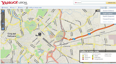
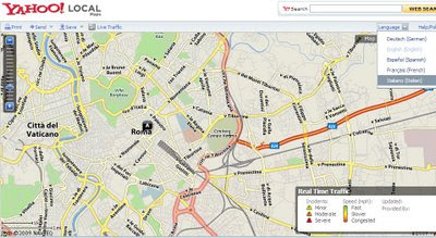
Yahoo Maps has had an update that seems to concentrate on localization
International Support is improved overall.

Yahoo Local Maps Language Switch Italian
Italian Maps Mode and Controls
Yahoo Local Maps Language Switch English
Yahoo make it far easier to change language, the page/map tiles do have to refresh in order to view the localised maps. Enlgish to Italian shown.

Yahoo Local Maps Language Spanish Mapas
Español Mapas, Maps for Rome Spanish Version.

Yahoo Local Maps Language French Canadian
French Canadian Maps available too.
  • Yahoo updates to US, US-Español, Canadian and Canadian French Mapping sites.
  • A language selector, easy selection from English, French, Italian, Spanish and German.
  • A miles/km selector, distances can be quickly changed.
  • Print page improvements
    • Drag/Pan/Zoom functionality for Print page maps.
    • Collapsible driving directions vertical to save space.
    • Driving Directions made wider and in a larger font.
    • Interactive map controls on the Print page. Useful for tweaking before printing.
Source:
http://www.ygeoblog.com/blog/2009/02/25/yahoo-maps-%E2%80%93-enhanced-international-support/

Labels: , , , , ,

20 August 2007

Hurricane Dean - Mapped and Tracked

Final Update:
The storm has reached Category Five, the highest strength, with winds of up to 160mph (255km/h).

Dean Hurricane at Category 5
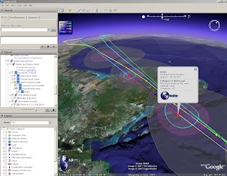
Radial Zones show destructive path of Hurricane Dean at Category 5

For a Visual Understanding - view the Hurricane Animated guide from the BBC (in Flash)


Update 3:
Dean is now forecast to slam into Belize and the east coast of Mexico's Yucatan Peninsula, including the popular tourist destination of Cancun.
http://news.sky.com/skynews/article/0,,30200-1280456,00.html?f=rss

Update 2:
meteorological reports the storm could intensify into a Category Five hurricane in the next few hours.
http://news.bbc.co.uk/1/hi/world/americas/6954296.stm

"
Dean is now expected to pass close by the low-lying Cayman Islands, before hitting Mexico in the coming hours"


Update:
For more information
http://www.nhc.noaa.gov/#DEAN

Currently Category 4
"Winds 131-155 mph (114-135 kt or 210-249 km/hr). Storm surge generally 13-18 ft above normal. More extensive curtain wall failures with some complete roof structure failures on small residences. Shrubs, trees, and all signs are blown down."
There is potential for this hurricane to be upgraded to category 5...eek!
" Dean is now over very warm water and in an ideal situation to strengthen further."
Rob McElwee, BBC Weather


Hurricane Dean - Mapped and Tracked

Hurricane Dean Tracked

View live updated content for Hurricane Dean with predicted courses based on category (currently 4).

The KMZ for Google earth comes with more information.
  • Oil and Gas Fields
  • Buoys (Windspeed, pressure etc)
  • Sea Temperatures (very important with hurricanes)
  • Clouds (Shows the scale of the hurricane)
  • Predicted Routes/Modeled Forecasts

more information from GraphOilogy Blog

Link to the KMZ (the latest release of Google Earth is required which is 4.1.1087.5048)

Labels: , , , , , ,

01 May 2007

ArcGIS Explorer (380 Build)

ArcGIS Explorer (380 Build) available for download from ESRI
(if you dare too)

ArcGIS Explorer Build 380
More Google Earth like, but slower.

"You can also change the appearance of ArcGIS Explorer by using skins. At present, each of the three skins that ship with ArcGIS Explorer has a distinct color scheme but does not differ in functionality. The skin color is determined by the color scheme active for your version of the operating system"
Rather have more functionality

Download ~(need an ESRI User Account to access the download)

ArcGIS Explorer Build 380 Crash

Yes it is a serious problem when you try opening a kmz file and it crashes.

ESRI please fix this.
And add support for Personal Geodatabases (your own files). (please)
They have shapefiles...

Labels: , , , ,

23 January 2007

Oblique Aerial Photos & More 3D Buildings Windows Live Local / Virtual Earth

Some nice 3D Photographic Images coming from Microsoft is are making their way through Windows Live Local / Virtual Earth

High Res Oblique Aerial Monte Carlo
Monte Carlo


Textured 3D Buildings in Miami
Miami in 3D
(use IE7 with 3D Virtual Earth Plugin pre-installed)

Source: Virtual Earth Blog

Labels: , , , , , ,

19 January 2007

Map Blog Feed For Mobile Devices

Get your Mapperz Blog Feed For Mobile Devices

Mapperz feed on your mobile device

This is a cut down version of what is available on the main mapperz blog and to reduce data charges, images removed and content is reduced to 50 characters.
  • Supports older web/wap enabled mobile phones.

Top Tip:Use GPRS (data transfer) mode rather than pay per minute on wap.

Blog feed to mobile feed provided by winksite.com

simply add this url
http://winksite.com/mapperz/mobile

Network charges vary.

Labels: , , , ,

05 January 2007

Mapperz joins GIS WIKI


Mapperz joins GIS WIKI

This Blog will be available through NewsFeeds

Labels: , , , ,

14 December 2006

ArcGIS 9.2 Service Pack 1

ArcGIS 9.2 Service Pack 1 will be released next week (18th December 2006)

No 'Issues Addressed' reported on the website yet.

But since most UK ArcGIS users have yet to receive ArcGIS 9.2

Top Tip: Do not install until SP1 is Downloaded and on CD.

So after months of alpha, betas and release candidates... you still need to patch up the holes.

If ESRI want to win more users, a public beta (one without having to spend 20% of your time reporting back to ESRI for Free).

Embarrassed? (you would be)

UPDATE:
ESRI (UK) confirmed today that ArcGIS Desktop 9.2 will not be available until February 2007.

Even though EDN 9.2 is Delivered to UK EDN Users.

Therefore ArcGIS Engine, Runtime etc cannot be used with Desktop

Nice One ESRI!

So that MapInfo....

Labels: , , ,

06 December 2006

Drag Polylines in Google Maps (v2.70)

Some nice new functions are coming out of the Google Maps API.
(trying to keep it simple but this post gets a bit geeky)

Drag Polyline v2.70 Esa Example
ESA has been busy and demostrates the draggable Polyline.

So whats the fuss about that? Well there are alot more discoveries in this update.

Mike Williams seems to know whats going on in the latest javascript update (v2.70)
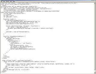
his comments below.

There's lots of strange goings on inside the API this time.

I've not yet worked out how to use it all, or what it all does.

I've not actually tested any of them yet. All this information is my
reading of the source code and crawling through that part of the DOM
that contains the functions. So it's quite possible that I've
misunderstood some of it.

New function
============
GVerify(la)
This one's weird. I can't see where they managed to hide the source. I'm
pretty sure that it isn't in the normal API code or in the API loader,
but the code somehow is present in the DOM.

New method
==========
GBounds.mid()
returns the GPoint at the centre of the GBounds.

Extra parameters
================
new GPolygon()
new GPolyline()
GPolyline.fromEncoded()
all accept one extra parameter, making a total of 7, 5, and 2 parameters
respectively. The additional parameter appears to be a set of
{GPolylineOptions}

New properties
==============
GPolyline.opacity
GPolyline.color
GPolyline.weight
Perhaps you can now do things like changing the weight of a polyline
when the zoom changes, and changing the colour when the maptype changes.
Previously the properties were inaccessible so you could only make such
changes by removing the old polyline and adding a new one.

If so, it's rather strange for Google to be exposing properties instead
of providing methods like GPolyline.setWeight() etc. It's not their
usual coding style.

New event
=========
visibilitychanged
Triggered by GMarker, GPolyline and GPolygon when their .hide() or
.show() method is called. Returns a parameter which is true for .show()
and false for .hide().

New GMarkerOptions
==================
description
name
zIndexProcess

zIndexProcess sounds like fun. You can set it to a function(marker,b)
that returns a zIndex value for the marker instead of using the normal
API internal function that puts the southerly markers on top.

new GPolyLineOptions
====================
id
name
outline
mapsdt

new GMapOptions
===============
mapOrderMarkers
It looks like you can set this to be a reference to an ordering
function, as used in an Array.sort() call. If you use the option, then
the API will call markers.sort(yourfunction). I've no idea why you might
want to do that.

new GDraggableObjectOptions
===========================
restrictX

--
If your a bit of a javascript buff you can access these functions by changing your api key code.
from:
http://maps.google.com/maps?file=api&v=2&key=YOUR KEY HERE

to:
http://maps.google.com/maps?file=api&v=2.70&key=YOUR KEY HERE


Well done Mike and Esa good work, nice examples coming soon

Labels: , , , ,

26 November 2006

gTraffic updated with Timeline

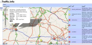
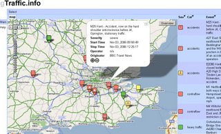
A nice update from gTraffic incorporating time to a Google Maps Mashup.
gTraffic Timeline MapgTraffic Timeline Chart

Using something called "GWT wrapper"

Looks like a first to Mapperz. Very well done.

Labels: , , ,

16 November 2006

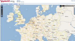
Yahoo Maps Released

Yahoo Maps released out of Beta.
Yahoo Maps Out of Beta
and the European Data has been updated.

Labels: , ,

09 November 2006

UK Addresses - Geocoded via Google Maps API

22 November
New UK Geocoding Addresses Service in Testing
http://mapperz.blogspot.com/2006/11/mapperz-requests-testers-for-uk.html

Final Update on this hot topic
http://hublog.hubmed.org/archives/001414.html

5pm
UPDATE No.2
For UK Geocoding of UK Postcodes is still possible via the Google AJAX Search
A very good Live example of this is Online Archaeology


1:45:05 pm
Mapperz from the mapperz blog
"Bugga"
1:45pm
Joel from the Google Map API Team
"There are no intended changes to the geocoding API - results in the UK and Japan should still be returning the 603 error code. We're tracking down the change now and hope to resolve it shortly. I'm sorry for the inconvenience!"

12 noon 9th November 2006.
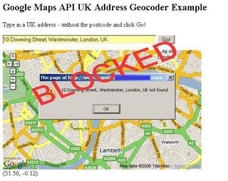
IMPORTANT UPDATE: Google Maps API have pulled the plug on UK Geocoding.

(It's all down to Crown Copyright of the Data - Royal Mail and Ordnance Survey)


UK Address Geocoding Blocked

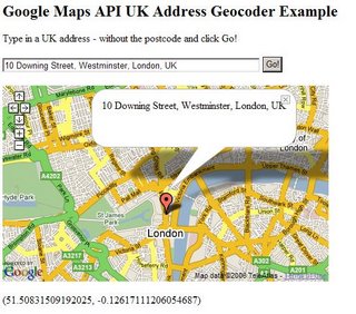
UK Addresses - Geocoded via Google Maps API

UK Addresses Geocoded using Google Maps API
Finally but NOT any offical word on it from the Google Maps API Blog hence no linking URL
(on request only. mapperz@gmail.com subject:UK Geocoding)

but you can tinker with the code on your own webserver:


UK Addresses Geocoded Code
sorry beta blogger hates html code pasted in.

Labels: , , , , , ,

07 November 2006

Virtual Earth 3D Launches

Official News Blog

Local Live updated - Virtual Earth Version 4

Virtual Earth 3DVirtual Earth 3D

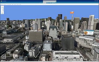
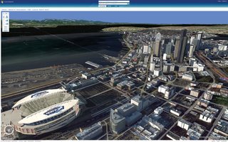
Microsoft uses aerial cameras that take photos of cities and render the images into Microsoft's Virtual Earth 3D, announced on Monday, allows advertisers to buy banner ads that float above buildings in photorealistic environments. The application, which downloads into a browser, melds together Virtual Earth's 3D features and Microsoft map and local search. In this screen shot, Zip Realty ads appear on virtual billboards

3D graphics for the new Virtual Earth 3D application, which downloads into a browser. The rendering creates photorealistic scenes featuring buildings, roadways and bodies of water.

Microsoft's Virtual Earth 3D melds together photorealistic cityscapes with its existing online mapping services, such as traffic reports shows color-coded freeways in Los Angeles indicating which roadways are congested and which are clear.

Microsoft's new Virtual Earth 3D online mapping interface allows people to "fly" through cities much as they would in virtual reality scenes and online games, with graphics that are as realistically rendered.

Three-dimensional models are available initially for 15 U.S. cities: San Francisco, San Jose, Seattle, Boston, Philadelphia, Los Angeles, Las Vegas, Detroit, Phoenix, Houston, Baltimore, Atlanta, Denver, Dallas and Fort Worth. Terrain imagery in 3-D is available globally, and Microsoft expects to offer 3-D imagery in an ever expanding set of cities. Other features provided by Live Search include access to real-time traffic information in select major U.S. cities, and access to business listings "yellow pages" and people listings "white pages" that allows consumers to easily find local information and act on it.

Update:
IE6 & IE7 only
to view 3D you need this plugin (but who wants to install another plugin?)
Mircosoft Servers are having serious issues at the moment (surprise, surprise).
Looks good when works!
Mapperz

Labels: , ,

03 November 2006

gTraffic Version 2

gTraffic version 2

Gtraffic Version 2
New Features:

- New look and feel with tabbed views.
- Zebra list style with sortable columns.
- Selection menu indicates which dataset is currently active.
- All event categories are now listed in traffic view.
- 'overview' button will take you back to dataset overview zoom level.
- Some help pages (working on improving this).
- 'Busy' indicator.
- Permalink feature.

A nice clean update. More details from the creator

Labels: , , ,

02 November 2006

New Features in Google Earth 4 Beta

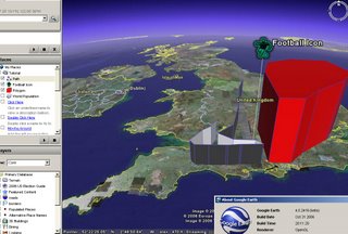
New Features in Google Earth 4 Beta (4.0.2416+)

Google Earth 4 Point Line Polygon

Now Supports:
Drawing of paths and polygons (was only available in Google Earth Plus)
Point Lines and Polygons can be Extruded with elevation or made floating in space.
New Icons for Placemarkers
Faster 3D model rendering
Improved lighting for models
Print of driving directions

More info
Google Earth Blog

Download Google Earth 4 beta (Free)

Official update
Labels: , , , ,