->

20 July 2010

StepMap - Create Free World Maps

StepMap - Create Free Personal World Maps

"StepMap is a free service, enabling you to create, edit and share individual and personalized maps. Also, it allows you to export your maps to any other web site. The term "map" includes all kinds of topics, themes and design option. StepMap offers you a free tool to create maps that represent your specific, personal requirements and design ideas."

Step Maps - Create Free World Maps - Step1
Create and customise your own world, regional or country map with this service.

Step Maps - Create Free World Maps - Step2
Change the style, add, symbols, images, media, text, metadata a comprehensive resource in creating very specific mapping for personal and commercial use.

Personal Commercial
Creating a Map using the Online-Editor FREE FREE
Presentation in the Map Directory FREE FREE
Save as private Map FREE FREE
Embedding the Map to another website FREE FREE
Additional web space for rich media FREE FREE
Adding to Google Search FREE FREE
Printing a Map FREE PAID


StepMap for Educational Purposes

The free of charge features that are listed for private users also apply for any educational purpose, e.g. schools, universities or research.

That means that teachers and students can use StepMap for free considering the general terms ad conditions.

http://www.stepmap.com/termsofuse2.php


Try creating your map

An example

Labels: , , , , ,

16 April 2010

Radar Virtuel European Airspace Map

Radar Virtuel European Airspace Map

Update: Now preset with the Volcano Ash Cloud Plume Layer

Volcano Ash Cloud Plume Map Layer
The grey zones represent the approximate area that the ash cloud from the Icelandic Volcano is in near real-time.


Radar Virtuel European Airspace Map
The Map says it all - No (or very limited) Flights in Northern Europe

Due to a volcano in Iceland the Eyjafjallajokull (pronounced "ay-yah-
FYAH'-plah-yer-kuh-duhl") glacier is producing a huge cloud at high altitude of ash that is covering large areas of Northern Europe restricting air travel.


View the 'Non' Air Traveling Map - http://www.radarvirtuel.com/
(site has been busy and might be slow today) - A Live Map

Labels: , , , ,

18 August 2009

Google Maps News - Street View & Map Maker

Google Maps News - Street View & Map Maker

update:19/09/09
Mexico is now available for Map Maker - please see the official blog post
http://google-latlong.blogspot.com/2009/08/map-maker-goes-west.html

StreetView has been expanded again this now covers
Switzerland and Portugal and also Taipei City in Taiwan

New Street View Chapel Bridge, Lucerne
Chapel Bridge, Lucerne with new Streetview coverage.

Google Maps Mania does a very good round-up of the coverage included
http://googlemapsmania.blogspot.com/2009/08/street-view-arrives-in-switzerland.html


Google Map Maker has been opened up some more with download-able vector data available for Africa [Terms of Use Apply]. This is either in KML format or Shapefile.

On the Mapmaker creation side Eastern Europe has now been opened up for editing.
This includes Albania, Belarus, Kosovo, Macedonia, Moldova, Montenegro, Romania and Serbia.
More news on this here
http://google-latlong.blogspot.com/2009/08/map-maker-gets-european-flair.html

Map Maker Africa Download
This data can be obtained by accepting the terms of use at this link
https://services.google.com/fb/forms/mapmakerdatadownload/
This data can be used in a GIS or Google Earth Application.

Labels: , , , , , , , ,

12 June 2009

Yahoo Maps Updated [Europe]

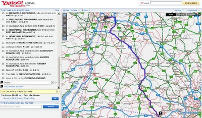
Yahoo Maps Updated [Europe]

Yahoo Maps New Drag Directions
Now it is possible to drag the routes...
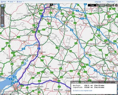
Yahoo Maps New Drag Directions - Compare Old and New Route
Yahoo draggable routes, with option to revert back to original, also compares the route distance.

Other new features & updates
In response to users feedback Yahoo made some major improvements to Yahoo Maps

  • Faster loading time -No more waiting for the application to load - Dial-up mode removed
  • Language preference – Choose from one of the 5 European languages: English, French, Italian, Spanish and German*.
  • Interactive print page – Customize the print page to include only the information you need.
  • Personalised routing – Don’t like the route yahoo provide drag and drop the routes interactively.
  • Saved locations – For convenience, previously entered locations are automatically stored and available within Maps and elsewhere on Yahoo, such as Local and Weather.
  • Quickly look up places through auto-completion.
  • Waypoint support – Get driving directions for trips with multiple stops.
  • Save driving directions – Two places to save, Yahoo! Bookmarks and delicious
  • Zoom bar – now with the ‘+’ on top.
*Yahoo will be rolling out the same set of Maps improvements in Germany in the coming weeks.

Try it
http://tinyurl.com/NewYahoo-Maps-Routes
(above example)

Yahoo Maps Europe main sites:
http://uk.maps.yahoo.com/ (UK)
http://fr.maps.yahoo.com/ (France)
http://de.maps.yahoo.com/ (Germany)
http://espanol.maps.yahoo.com/ (Spain)

Labels: , , , , ,

21 November 2008

New AA Route Planner Beta

New AA Route Planner Beta

The AA Route Planner is under going an update - here is the first blog mention of it.

AA Route Planner Beta Map AA Overview
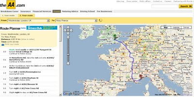
Google Maps based, but AA have their own Custom Maps in the Info Windows (click the sidebar and an info window at the location is displayed)

AA Route Planner Beta Map
European Directions includes channel crossings, Ireland is also covered.


The switch from old the ArcIMS to Google Maps API but preserving the additional functionalities of the old routing [sidebar in graphic form - the road sign structure]. It is still under beta and things might change and improve, Points of Interest (POI's) along the route might be useful.

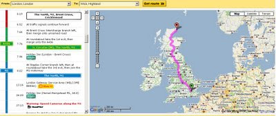
AA Route Planner Beta Map UK
The Sidebar is interactive and is displayed as the driver would recognise the signage [Primary Route Green, Motorway Blue etc.]

Try it out
http://www.theaa.com/route-planner/index.jsp

Old Version is still available
http://www.theaa.com/travelwatch/planner_main.jsp?database=B

Mapperz

Labels: , , , , , ,

20 August 2008

Free Maps for Education (in PDF format)

Free Maps for Education (in PDF format)

Maps International
have release free maps in A3 paper size
(297mm×420mm or 11.7''×16.5'')

Maps International Educational Free Maps - Europe
Politically coloured Europe map for Free

Maps International Educational Free Maps - World
This World Map is available for educational use at not cost.
(Politically coloured World map with hill shading and bathymetry.)

"Maps International Education shop provides education wall maps and geography teaching resources and aids for all ages. Our product range is extensive and includes the new exclusive Primary Schools wall maps. Also available to purchase are key geography texts for higher and further education including subjects such as Earth Sciences, Regional and Area Planning and many more Geography based subjects."

Other Free Maps available:
  • UK map with major transport links including motorways, primary routes, ferry routes and airports.
  • UK map with major transport links including motorways and airports.
  • UK map with parliamentary boundaries and names.
  • Wales map with country/ county/ district/ unitary boundaries and names
  • Scotland map with country/ county/ district/ unitary boundaries and names
  • England map with country/ county/ district/ unitary boundaries and names.
  • Europe map with hill shading and hypsometry.
  • Outline black and white World map with country borders, capitals and country names.
  • Outline black and white World map with country borders only.

These Maps in PDF format are available from
http://www.mapsinternational.co.uk/education_downloads.asp

TERMS OF USE
All material is copyrighted and should not be reproduced for commercial use. If you intend to use the free resources for anything other than classroom use, then contact Maps International on Free Phone 0800 038 6277 or sales@mapsinternational.co.uk to discuss the cost and royalties applicable. No responsibility can be assumed for the accuracy of the information given.

Labels: , , , , , , , , ,

14 August 2008

Eye On Earth - Water Watch (Europe)

Eye On Earth - Water Watch (Europe)
Water Watch Eye on Earth
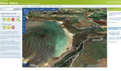
See and rate how clean your beach is. European Environment Agency launched the Eye on Earth water campaign, using the Microsoft Virtual Earth platform. The new campaign monitors beach water quality along the coasts and allows the reporting of quality concerns. Virtual Earth provides a bird’s-eye view of beaches that users plan to visit and helps provide information on the cleanliness of the water before they make a trip.

"Eye on Earth retrieves data from 21,000 monitoring points across Europe, presenting recent water quality ratings for bathing sites in 27 countries, and for some beaches, historical ratings for up to the past 18 years. Countries including Greece, Italy, Malta, the Netherlands, Slovenia, Portugal and Slovakia will also display the latest 2008 data, with more countries expected to update information in the near future. A traffic-light-style evaluation of water quality based on traditional monitoring methods is supported by similar ratings reflecting the experiences of people who have visited the beach. Combining these streams of information provides accurate and up-to-date information on bathing water quality across Europe, and makes it available to anyone who has access to the internet."
Source: Microsoft Press Release

Water Watch Eye on Earth in 3D
Sennen Cove, Cornwall in 3D.
Beaches can also be viewed either in Birdseye View (Oblique Aerial) or in 3D View as above.
For a UK Birdeye View Beach, visit Bournemouth or Brighton.

"Eye on Earth allows users to zoom in on a given section of the coast or riverbank, both in street map or bird’s eye viewing formats. A ‘traffic-light’ evaluation (red, amber, green) of water quality based on scientific monitoring methods is supported by similar ratings reflecting the experiences of people who have visited the bathing site.

As part of the five-year partnership announced last May, the EEA and Microsoft will continue to develop the Eye on Earth portal by adding new sets of environmental information."

http://www.eea.europa.eu/highlights/heading-for-your-favourite-beach-is-the-bathing-water-clean

Suggestion: Great to see water quality, but having a rating on the conditions and potential dangers (rip tides, strong currents, large tidal range etc) would also be useful to the potential tourist.

Labels: , , , , ,

13 August 2007

Map Seeaarch - but who wins?

Seeaarch is a quick fire, map and directions search website that uses 4 mapping solutions

Map Searches
  • Yahoo
  • Google
  • Live
Directions
  • Yahoo
  • Google
  • Mapquest
Though a quick test reveals a clear winner.

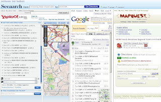
Seeaarch Results - Winner
note: moving the columns is possible to show each one more clearly.

Yahoo gets confused but tries (finds an American route)
Google does the job - as you would expect
Mapquest failed to find the start location

Mapperz requests directions from
10 Downing St, Westminister, London, UK
to SW19 1AR (Wimbledon)

So there a quick and effective test.
(So why not just use Google Directions?)

When Planning a route, whether it is in the UK, Europe or any other part of the world, don't just rely on one solution.
The AA Travel Planner is more effective than any of the above in the UK. The driving times are more accurate and the congestion travel information is more up-to-date.
For Europe try Yahoo Maps

Labels: , , , , , , , , ,

18 June 2007

Better European Driving Directions - Yahoo Maps

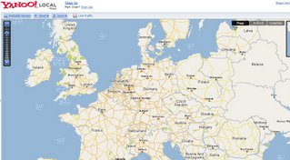
Yahoo Maps are now providing better European driving directions.


Now you can cross borders and sea's and get accurate driving times (exclude traffic jams) to places right across Europe. The Example shows from Belfast to Galaţi (Eastern Romania) Stopping off in Paris (for a croissant) will take you 41 hours and 8 minutes (approx).

Driving directions within 34 European countries include:

Western Europe - Complete coverage
Austria, Belgium, Denmark, Finland, Germany, Great Britain, Luxembourg, Netherlands,
Ireland, Norway, Portugal, Spain, Sweden, Switzerland, France, and Italy.

Eastern Europe – Comprehensive coverage
Albania, Bosnia/Herzegovina, Bulgaria, Croatia, The Czech Republic, Estonia, Greece, Hungary
Latvia, Lithuania, Macedonia, Poland, Romania, Russia, Serbia/Montenegro, Slovakia, Slovenia, and Turkey

Redesigned interactive print page makes it easier to print and read driving directions.

Yahoo will introduce new in-country Maps sites in France, Germany, Italy, Spain and the UK.

(You can already take a look at Yahoo! Maps India, currently in beta)

Labels: , , , ,

04 June 2007

Google Earth Images Massive Update for UK

Mapperz noticed late last night that Google Earth images for England and Wales have dramatically improved in resolution of aerial images.

Other areas of Europe and the World have also been updated.

full list:

Germany now looks much better thanks to special colour mapping techniques which were used for Switzerland previously!
UK updated - Most of England is now in high resolution.
Parts of Greenland
Antarctica - some strips of high resolution down here
Parts of Canada with new high resolution, big area around Toronto
Catalonia part of Spain
State of Alabama
St. Paul, Minnesota
Puerto Rico has more high resolution
Iran has lots of new Digital Globe satellite strips
New Zealand has some new coverage
Parts of Russia

from the Google Earth Blog

Google Earth is now onto Version 4.1 (beta)

Labels: , , , , ,

16 November 2006

Yahoo Maps Released

Yahoo Maps released out of Beta.
Yahoo Maps Out of Beta
and the European Data has been updated.

Labels: , ,