->

06 October 2009

Discover,Evaluate & Develop - New Ordnance Survey Licences

Discover,Evaluate & Develop - New Ordnance Survey Licences

Ordnance Survey have found the word 'Innovate' and have changed the way they 'give away' (at cost*) data for
Discovering,Evaluating and Developing Ordnance Survey data.

The New Licencing Models:-

Discover:
if you are a private individual, new customer, social entrepreneur, or represent a social group or start up company. You can use the data for your internal evaluation and testing purposes only. You cannot develop or demonstrate the data. It is free of charge and can be used as long as you adhere to the terms. Terms PDF

Evaluate:
You may be interested in this licence if you are a new or existing customer who would like to take a larger area of OS data to evaluate, test or demonstrate internally. You can take this data initially for a maximum of three months. Standard supply is up to 10% of Great Britain. This licence is free of charge.
*Though if your order 10.1% of Britian you will be charged £500 payable within 30 days.
Terms PDF

OS Vector Data Formats Available
Many of the Ordnance Survey Datasets are available to download in various GIS formats so no data conversion is required. Simply load into your GIS sofatware.

Developer:
You may be interested in this licence if you would like to develop, test and demonstrate our data to your potential customers.

Our standard supply of Developer Data is for the Plymouth area. Products, formats and exact areas covered are on the Developer Data overview page.

You can use the data for 12 months (except for any third party products listed in the licence where the term can be reduced to 3 or 6 months) and the licence to do this is free of charge.
Terms PDF

FAQ's

How long can I use the data for?

Discover Data– until we terminate the licence.
Evaluation Data – You can take this data for three (3) months except where you request and we agree to supply more than four (4) individual kilometre tiles of OS MasterMap Imagery Layer, which will be for a period of one (1) month.
Development Data – 12 months from the date of despatch, after this time the licence will automatically renew on the same terms. Term for the 3rd party products is also 3 months from the date of despatch.

How much data can I have?

Discover Data– You can download what is on the website.
Evaluation Data – up to 10% of national cover as standard.
Developer Data – Plymouth area as standard.

Which products are available?

** Rasters require world files for GIS software to geo-reference each image available here
***not sure why this data is made available is 'frozen' (dis-continued)

Can I have, for example, three different areas of 10% cover?

Under the Evaluation licence you can have one geographical area of 10% for different products.

What do I do if I want to order the same area for a different product a few weeks after I placed my first order?

You need to complete another request form for the second batch of data.

What happens with the evaluation licence at the end of three months?

You should cease use, destroy and delete the data or contact us if you still need to use the data.

Source:
http://www.ordnancesurvey.co.uk/oswebsite/products/innovations/

Though at the end of the day does it innovate you?

Labels: , , , , , , ,

18 August 2009

Google Maps News - Street View & Map Maker

Google Maps News - Street View & Map Maker

update:19/09/09
Mexico is now available for Map Maker - please see the official blog post
http://google-latlong.blogspot.com/2009/08/map-maker-goes-west.html

StreetView has been expanded again this now covers
Switzerland and Portugal and also Taipei City in Taiwan

New Street View Chapel Bridge, Lucerne
Chapel Bridge, Lucerne with new Streetview coverage.

Google Maps Mania does a very good round-up of the coverage included
http://googlemapsmania.blogspot.com/2009/08/street-view-arrives-in-switzerland.html


Google Map Maker has been opened up some more with download-able vector data available for Africa [Terms of Use Apply]. This is either in KML format or Shapefile.

On the Mapmaker creation side Eastern Europe has now been opened up for editing.
This includes Albania, Belarus, Kosovo, Macedonia, Moldova, Montenegro, Romania and Serbia.
More news on this here
http://google-latlong.blogspot.com/2009/08/map-maker-gets-european-flair.html

Map Maker Africa Download
This data can be obtained by accepting the terms of use at this link
https://services.google.com/fb/forms/mapmakerdatadownload/
This data can be used in a GIS or Google Earth Application.

Labels: , , , , , , , ,

03 August 2009

Cloudmade: Directions Africa Cape Town to Ethiopia

Cloudmade: Directions Africa Cape Town to Ethiopia

OpenStreetMap gets a boost with capable directions now across Africa


Africa Directions from Cape Town to Ethiopia click 'Hide' view the map route on the map.

view the url:
http://maps.cloudmade.com/?lat=-9.622414&lng=11.25&zoom=3&directions=-33.914731015167575,18.423986434936523,
3.5024553022772564,39.056396484375&travel=car&styleId=1

Other Cloudmade news
http://blog.cloudmade.com/
CloudMade partners release new mobile libraries

Raster Libraries

Vector Libraries

Nutiteq have long been a trusted CloudMade partner providing mobile libraries. They have now added CloudMade support for two leading mobile platforms - Blackberry and Android. Blackberry commands a high worldwide market share for smart phones and is the leading platform for email and enterprise. Google’s Android has set a new bar for open source mobile OSes, and we expect a number of new handsets to come to market during the remainder of this year. Both libraries give access to a full range of CloudMade services including custom image tiles, geosearch and routing.

Labels: , , , , ,

31 March 2009

South Downs National Park Maps

South Downs National Park Maps
New 'South Downs National Park' - Confirmed
The new South Downs National Park - Overview [image for illustration]

On 31st March 2009 this has now be confirmed.

http://www.defra.gov.uk/wildlife-countryside/protected-areas/national-parks/south-downs/index.htm


Maps of the new National Park
http://www.defra.gov.uk/wildlife-countryside/pdf/protected-areas/national-park/south-downs/boundary-map.pdf

Western Section [Maps 1-11 & 41-49]
Central Section [Maps 11 -20 & 34-40]
Eastern Sections [Maps 20 -33]

Beachy Head - http://www.naturalengland.org.uk/Images/Map%2027_tcm6-10384.pdf

More South Down National Park Annex Maps
http://www.planning-inspectorate.gov.uk/southdowns/documents/PositionPapers.htm

Decision Letter [No Maps]

GIS data is available - http://www.gis.naturalengland.org.uk/pubs/gis/GIS_register.asp
[In Shapefile Format]

In the News
http://news.bbc.co.uk/1/hi/england/7973417.stm
http://www.guardian.co.uk/environment/2009/mar/31/south-downs-national-park

Labels: , , , ,

11 March 2009

Mapping the News API (Guardian)

Mapping the News API

The Guardian is now Geocoding/Mapping it's News Articles with it's New OpenData APIMapping the News API - Guardian

A neat way of finding news articles by location.

Experiment with the new API
http://www.guardian.co.uk/open-platform/getting-started

Start Page for Guardian Map API
http://guardian.apimaps.org/index.html

GeoCode this! (try a search term)
http://guardian.apimaps.org/search.html

CloudeMade Mapping
http://guardian.apimaps.org/map.html


Note: Articles that do not have a location can be updated by readers

Example search
http://guardian.apimaps.org/search.html?q=London

For Budding Developers:
Data Structure of the API
http://guardian.apimaps.org/data.html

Map API integration:
News articles by The Guardian.
Maps © 2009 CloudMade, map data CC-BY-SA OpenStreetMap.org contributors.
Place searching by Flickr. Font reset by YUI. Cheerleading by SteveC.
Design and code by Stamen Design.

Source:
http://www.programmableweb.com/mashup/guardian-api-maps

Labels: , , , , , , ,

10 August 2007

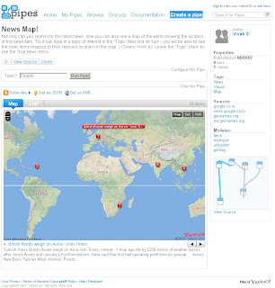
Yahoo Pipes - News Map - Output KML

Yahoo Pipes - News Map
Finally a Yahoo Pipe that uses a map to visualize the found results.

Yahoo Pipe Map - Author Vivek C

Author of the Pipe is Vivek C

Though there were not many feeds to the Map - The useful thing with Yahoo Pipes is that when it is published it is available to public and 'Copies of' can be created (sign in to yahoo required).

Here is Mapperz version of this
Yahoo Pipe Map Mapperz Version
This Map is overlaying rss feed from the yahoo pipe model below
Yahoo Pipe Map Model - Mapperz Version

Add RSS feeds is very easy to apply - use the + icon on the url feed.
Mapperz added some extra rss feeds
BBC News
Reuters UK
Sky News
CNN
and the Mapperz Blog


But the clever thing about this pipe is that it is using a normal rss feed then using geonames.org to apply a latitude and longitude to the rss feed > therefore creating a georss feed. This is then overlayed on a yahoo map showing the locations around the world.

Yahoo Pipe Map KML - Google Earth
One final point, you can export the results to KML and view in 3D using Google Earth.
One helpful scenario would be if you were looking for a new house and you can request different estate agents and overlay and view the surrounding area.

Labels: , , , , , ,

27 June 2007

Sky News - UK Flooding Map (Pics)

Update - if your looking for UK Floods in Southern, West and Midlands [20th July to 24th July 2007]
Go to the newer page
http://mapperz.blogspot.com/2007/07/uk-flooding-links.html


Sky News UK Flooding Map showing pictures of the Flooding in the North of England - News has Location.


Sky News UK

More and more Maps are Illustrating news events - giving the users a sense of the scale of the matter.
(other parts of the UK have been affected - though the North of England has had it very bad.)

Source: Google Maps Mania via Press Gazette

More Flooding Pictures from the BBC Site

Labels: , , , , ,

22 May 2007

BBC, Nokia & Ymogen = GeoStories

News has location
BBC, Nokia & Ymogen team up to create GeoStories

GeoStories is a project combining GPS, News and Innovation together. Students from Brighton University have started this unique project.

This is a very likely and useful way of reporting news and adding location to the story.


Geo-Stories Project
GeoStories uses Google Maps to show locations of events per story

"Ymogen are working with Nokia and BBC Innovation to produce Geo-Stories, an innovative 'citizen story' project, which explores how content (video, pictures and text) combined with location and time can most effectively be used to create crowd pulling stories."

Nokia N-series mobile phone(s) are used to store location and record video and geotagged photos

View the GeoStories

Posted by Mapperz in Canada

Labels: , , , , ,

05 January 2007

Mapperz joins GIS WIKI


Mapperz joins GIS WIKI

This Blog will be available through NewsFeeds

Labels: , , , ,

17 November 2006

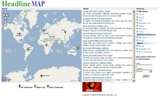
News has Location - Headline Map

Google Maps Mania posts are filled with the lastest google maps mashups.
Headline Map is one that stands out...

Headline Map

Rich in multiple data sources cross referenced with location. This provides the user with World Headlines, Continental, Regional and Country News. This site is clean and responsive to the user. Users can submit feeds into this site. Mapperz gives this the thumbs up.
Well Done Headline Map.

Headline Map gives its credit to:
  • Google, for providing the amazing Google Map API
  • Topix.net, for providing granularity to this site due to their vast coverage
  • Flickr, for providing the pics of each location

Labels: , , , , ,