->

11 December 2008

Blogger Gets Geotagging (GeoRSS Support)

Blogger Gets Geotagging (GeoRSS Support)


Available through http://draft.blogger.com/

"With geotagging, you can add a location to your each of your blog posts. Just as time stamps help readers find posts from a certain date or time, geotags give your readers a way to browse posts near a specific location"
GeoRSS Support included in each post’s location in your blog’s RSS and Atom feeds using GeoRSS, a standard for geotagging. This means that feed readers, map applications and search engines can associate your posts with their locations.

Geotagging has a few known issues. We'll be addressing them shortly, but here are some suggested workarounds for the near-term:
  • The location editor is hidden behind the text field in the Edit HTML tab. Please switch to the Compose tab to view and edit locations.
  • A geotag cannot be removed from a post once it has been saved. If you need to remove a geotag, please copy your post content into a new post and delete the geotagged post.
  • Update 2:33pm: If you have a customized template and you don't see the "Location:" byline, you may need to reset your blog's widget template. Do this by going to the Layout > Edit HTML tab in your dashboard, and then clicking Revert widget templates to default below the main text field.
  • Update 2:33 pm: Some users are having issues with the blog post map gadget. Brian is investigating.
source:

Labels: , , , ,

28 June 2007

Map Your Picasa Web Photos

Map your photos

See your photos arranged on a map, and show friends exactly where you took your best pictures. Simply type a location into the ‘Place Taken’ field when creating a new album, or refine a photo’s placement using a drag-and-drop map. It’s a great way to share photos from a summer vacation or road trip.

Example (Official)

Source: Googlified

Mapperz Demo

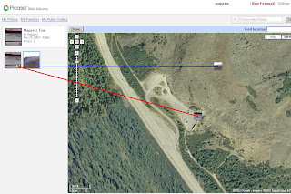
Geotagging (Georeferencing) Photos in Picasa New Feature

To manually Georeference your photos, select the album and view map enter a rough location, then centre the map and zoom in to where you remember the photo was take. Pick up the photo thumbnail and drag it across the map. Then the Latitude and Longitude is automatically assigned to the image. Simple as that.


Labels: , , , ,

22 May 2007

BBC, Nokia & Ymogen = GeoStories

News has location
BBC, Nokia & Ymogen team up to create GeoStories

GeoStories is a project combining GPS, News and Innovation together. Students from Brighton University have started this unique project.

This is a very likely and useful way of reporting news and adding location to the story.


Geo-Stories Project
GeoStories uses Google Maps to show locations of events per story

"Ymogen are working with Nokia and BBC Innovation to produce Geo-Stories, an innovative 'citizen story' project, which explores how content (video, pictures and text) combined with location and time can most effectively be used to create crowd pulling stories."

Nokia N-series mobile phone(s) are used to store location and record video and geotagged photos

View the GeoStories

Posted by Mapperz in Canada

Labels: , , , , ,

07 May 2007

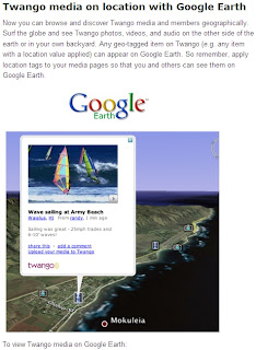
Twango - Multimedia in Google Earth

Twango - Multimedia in Google Earth

Twango content in Google Earth

How to use:

Install Google Earth

View geo-tagged media from the Twango community:
most popular media, most popular members (approx location), most recent media, most recent photos, most recent videos, most recent audio

Geo-tagged media from a particular channel:
Go to the channel page, click the Subscribe button, then click the icon on the popup.

View all geo-tagged media from a particular member:

Supported file types: 3g2, 3gp, 3gp2, 3gpp, 3gpp2, aac, aif, aifc, aiff, amr, asf, asr, asx, au, avi, bmp, cad, cmx, cod, css, dib, doc, dot, dtd, dwf, fla, flv, gif, ico, ief, ifo, ipx, jfif, jpe, jpeg, jpg, lsf, m1a, m1v, m3u, m4a, m4p, m4v, mdi, mid, midi, mov, movie, mp2, mp3, mp4, mpa, mpe, mpeg, mpg, mpp, mpv2, mqv, nsc, odf, odg, odp, ods, odt, pbm, pdf, pgm, png, pot, ppm, pps, ppt, psd, pub, qt, ra, ram, ras, rgb, rmi, rtf, rtx, scd, sit, snd, swf, tif, tiff, tsv, txt, vsd, vss, vst, vsx, vtx, wav, wax, wbmp, wm, wma, wml, wmp, wmv, wmx, wri, xbm, xla, xlc, xlm, xls, xlt, xlw, xml, xsd, xsl, xslt, z, zip.

More info:
http://blog.twango.com/

Labels: , , , ,

30 April 2007

Geotagging N95 Camera Photos to Google Maps

Geotagging N95 Camera Photos to Google Maps

update 30/04/2007
Ogle Earth reviews Digital Urban's post and ShoZu (more info).

Digital Urban beat Mapperz to it (had done this in practice, honest).

Digital Urban N95 Geotagged Photo
The result Geotagged Photo in Google Maps, Content from Digital Urban.

To do this you will need:
1x N95
1x ShoZu
1x Yahoo/Flickr Account
1x Google Account

So will hand you over for full details
http://digitalurban.blogspot.com/2007/04/how-to-geotag-
photographs-from-nokia.html


N95 users notes a special additon of ShoZu is coming out for the N95 soon.
"Thanks for your review of ShoZu :-) We're working on a special version for the N95 with a few cosmetic fixes and also the ability to automatically 'wake' the gps antenna without you having to load the Maps app in the background."
Source: Digital Urban comments

We look forward to it.

Labels: , , , ,

09 March 2007

Google Maps Photos - Geotagged

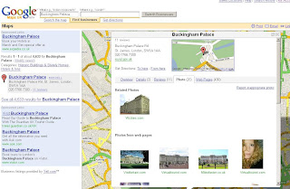
Google now maps relates photos by description (geotagging)
http://en.wikipedia.org/wiki/GeoTagging

Google Map Geotagging Photos Related to Map Search
Find 'Buckingham Palace' returns Map and Photos

This a form of Metadata where information about the data you search on is returned

Other possibilities for metadata are

Statistics (Area, Height, Volume)
Historic (This building was build in)
Structure (This Building is made from)
the list goes on...

Labels: , , , ,