->

20 April 2009

Via Michelin Revamp (Maps, Routes & Photo's)

Via Michelin Revamp (Maps, Routes & Photo's)

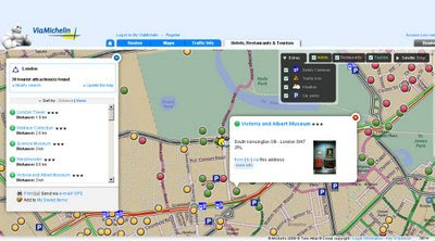
Via Michelin Maps Revamp - Points of Interest
Lot of new content availble in Via Michelin Maps - Speed Cameras, Traffic Incidents, Parking and Weather available across Europe.

Via Michelin Maps Revamp - Routing
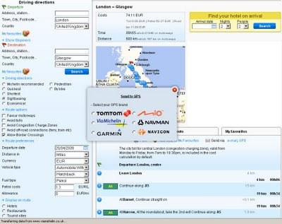
Full routing (Directions) right across Europe - France to Turkey in this case.

Via Michelin Send to GPS
GPS users can send themselves routes (directions) six different types are supported.
Note the good selection of alternative routes - sightseeing, economical quickest, shortest, pedestrian and bike.
Different types of automobiles (with caravan etc) and fuel cost calculator.
Display Hotels, Restaurant and Tourist site on-route.

Very impressive revamp from Via Michelin - the more you look the more there is with this site.

Via Michelin PhotoExplorer Labs (beta)
PhotoExplorer is currently in Labs (beta) with Via Michelin but looks familiar to the panorama layer google maps has (but it is Via Michelin own content).
more labs products:
http://labs.viamichelin.com/


Via Michelin is available in many more languages (Click the Flag Icon at anytime)
Native is French - http://www.viamichelin.fr/viamichelin/fra/tpl/hme/MaHomePage.htm

Labels: , , , , , ,

23 September 2008

Nokia ViNe Alpha (Mapping)

Update 23/09/2008
There is now a Nokia Mapping Application available to view your 'geotagged' photos using
the new Nokia Photo v1.5 (Beta)

Nokia Photo Maps - Stacking Photos on Location
Multiple photos on the same geographical location are stacked.

For a full and in-depth review on the functionality visit

http://www.allaboutsymbian.com/news/item/8097_Nokia_Photos_15_now_available_.php

To download the Windows (Mac coming soon?)
http://www.nokia.com/betalabs/photos
(NokiaPhotos_1_5_200_en_gb.exe is a 53.8mb download)

Seems to me that Nokia are now competing with Google Picasa 3.
Though the Nokia application seems to be more seamless with loading geotagged photos from your phone and showing those photos on a map than Picasa is.
Maybe Picasa 4 will make use of the Google Map API and overlay photos onto that.... there is hoping.

Nokia ViNe Alp
ha (Mapping)
Nokia ViNe
Nokia ViNe application is currently in closed Alpha but the website is up and running.

"new geo-tracking-photo-and-video-and-music application"
Clinton Jeff - Darla Mack


Nokia ViNe Mapping Tracks
ViNe combines and uploads music, photos and gps tracks you record from your Nokia Device on one process.

Combine following applications:
Nokia Sports Tracker (Still Beta)
Nokia Lifeblog (Photos)
Nokia Music Player
GPS (GeoTagging)

Why the fuss? Why not use the applications that already exist?
It's one application that encapulates three applications and expands the mapping potential of geo-location tagged files (photo,music & video).
The Mapping is based in flash (website) - the users tracks link photo, music and videos that were captured when the ViNe Application is set to record.
There are concerns over the battery life - lucky for Nokia this is still in pre-release alpha and can be addressed before a public beta version.
Nokia's LifeviNe project has been renamed, it seems, to just Nokia ViNe.

There is nothing new but - for the non-savvy phone user it makes it easier for the user to record trip for sharing with friends afterwards.

For a more in depth review of the new application vist the Darla Mack Blog below where the whole process is shown.

Sources:
http://www.allaboutsymbian.com/news/item/8088_Nokia_ViNe-Practical_or_Pointl.php
http://www.darlamack.com/darlamack/2008/09/nokia-lifevine.html

At least Nokia are making use of Navteq data, now that Google Maps is completely TeleAtlas based.

Labels: , , , , , ,

30 January 2008

Nokia Beta Labs - Location Tagger

Nokia Location Tagger
(georeferencing your phone camera photos)

Nokia Location Tagger

"What is it all about? Nokia Location Tagger is a small application running on “selected” S60 3rd devices that allows you to tag pictures captured from Camera application with geographical coordinates from GPS. The tagging process itself is sometimes called geotagging or geocoding (see also this article at Wikipedia). Technically, the location information is stored in the EXIF header of your pictures (.jpg file)."

Nokia Location Tagger S60


With Nokia Location Tagger, you can automatically tag your location data to your pictures. As you take a picture, your GPS coordinates are saved to the EXIF header of the JPEG file. You can use this data later, for example, to locate your pictures on a map.
In the near future, we hope to make location tagging a seamlessly integrated part of your Nokia experience. Until then, Nokia Location Tagger is a small standalone application that gives you a sneak preview. We are not planning to productize this application as such, but we’d love to hear your thoughts already now, so that we have time to take it into account in the mainstream development.
Tested with Nokia N95, N95 8GB, N82, and E90 using the integrated GPS. Should work but not fully tested with all S60 3rd edition devices using an external Bluetooth GPS receiver. Sharing your location-tagged pictures online requires Share Online 3.0.

- Launch Nokia Location Tagger application.- On the main screen, you will see the status of your GPS module. It will show the coordinate if GPS module is active. Otherwise, it will show "Searching".- To tag pictures with GPS coordinates, simply use the built-in Camera application. Press the Camera button of your device to take pictures as usual. When Nokia Location Tagger is running in the background, you will see small icon at the top left corner of Camera’s view finder. This indicates the status of GPS module: Green: GPS module is active. Amber: Nokia Location Tagger is connecting to GPS module or searching for GPS coordinate. Red: GPS module is inactive.

Q: What happens if I take pictures while the GPS module is not active yet?

A: Nokia Location Tagger tries to tag pictures to the last "known" coordinates in the last 10 minutes. Since GPS module normally takes some time to initialize, it’s better to launch Camera application a couple of seconds before taking pictures. Launching Camera application will activate Nokia Location Tagger; which will initialize GPS module. You can also bring Nokia Location Tagger window to the foreground to initialize GPS module.


Q: Will my battery be empty very fast when running Nokia Location Tagger in the background?A: Nokia Location Tagger has a time-out feature (by default, it is 5 minutes). If there is no picture until time-out time, the GPS module will be turned off. This will normally save power. you can change the time-out option in the settings (2, 5 (default), or 10 minutes)

Q: How can I view the GPS coordinates of my pictures?A: The GPS coordinates are stored in the EXIF header of JPEG files. Some online sites, such as Flickr and Panoramio are able to display GPS coordinate from the EXIF. For more info on these services, please see below. You can also use photo organized software that read EXIF, such as Picasa (with the combination of Google Earth).
Q: How can I set Flickr to automatically import location in my uploaded pictures, and place them on a map accordingly?A: Please go to this URL: http://www.flickr.com/account/geo/exif, sign in, tick the yes please box and click save. From now on, all new tagged pictures that you upload will automatically be placed on a map. Also underneath every picture, there will be a map link that - after you click on it - shows where the picture is taken. Here are some examples. A nice alternative to Flickr is Panoramio. After uploading your pictures, you can view them on Google Maps but also export them to Google Earth. Here are some examples.
issues- The pictures from secondary camera are not tagged. Nokia Location Tagger tags pictures from the main camera only.- In a very rare case, Nokia Location Tagger may not be able to tag picture with the error message "File is being used".- Pictures captured in burst mode may not be displayed in order in the Logs tab.- This version has been tested on N95, N82, E90 as well as N73, N81 with external GPS module (Nokia LD-4W). It should work on all other devices; but there is no guarantee at this point.

What can we do with the Geo-tagged pictures? You can upload them to the photo sharing sites, such as Flickr, Panoramio and Picasa Web, so that your friends know where the pictures were taken. If you want to keep them private on your PC, some photo organizer applications, such as Picasa (combined with Google Earth), are able to display location information.
Please read the instructions at Nokia Location Tagger web page.

Labels: , , , , , ,

28 June 2007

Map Your Picasa Web Photos

Map your photos

See your photos arranged on a map, and show friends exactly where you took your best pictures. Simply type a location into the ‘Place Taken’ field when creating a new album, or refine a photo’s placement using a drag-and-drop map. It’s a great way to share photos from a summer vacation or road trip.

Example (Official)

Source: Googlified

Mapperz Demo

Geotagging (Georeferencing) Photos in Picasa New Feature

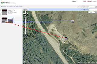
To manually Georeference your photos, select the album and view map enter a rough location, then centre the map and zoom in to where you remember the photo was take. Pick up the photo thumbnail and drag it across the map. Then the Latitude and Longitude is automatically assigned to the image. Simple as that.


Labels: , , , ,

09 March 2007

Google Maps Photos - Geotagged

Google now maps relates photos by description (geotagging)
http://en.wikipedia.org/wiki/GeoTagging

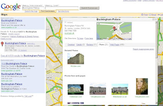
Google Map Geotagging Photos Related to Map Search
Find 'Buckingham Palace' returns Map and Photos

This a form of Metadata where information about the data you search on is returned

Other possibilities for metadata are

Statistics (Area, Height, Volume)
Historic (This building was build in)
Structure (This Building is made from)
the list goes on...

Labels: , , , ,