->

22 March 2010

Online Spatial Database Clouds - SQL Azure

Online Spatial Database Clouds - SQL Azure
(spatial database support coming due to demand of user feedback)

SQL Azure Spatial POI Along Route
Using a Spatial database (SQL Azure) to find Gas (petrol) Stations along a route.
New Functionality - Azure Spatial Database Support using cloud computing related topic - http://en.wikipedia.org/wiki/SQL_Azure


Last Wednesday (March 17th), Dave Robinson of the SQL Azure Team announced upcoming support for spatial data in SQL Azure. You can view the announcement at the MIX Conference in the video of Dave’s presentation, Building Web Applications with Microsoft SQL Azure (go to 18:40 on the timeline for the start of the spatial data portion of his talk).
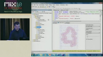
SQL Azure - Spatial Buffer
Spatial buffering a polyline - but across the web (not local database) - Windows SQL Azure will have spatial capabilities - to be released April 2010.

"SQL Azure provides a highly available and scalable relational database engine in the cloud. In this demo-intensive and interactive session, learn how to quickly build web applications with SQL Azure Databases and familiar web technologies. We demonstrate how you can quickly provision, build and populate a new SQL Azure database directly from your web browser. Also, see firsthand several new enhancements we are adding to SQL Azure based on the feedback we’ve received from the community since launching the service earlier this year."

This uses the same technology as Microsoft SQL 2008 Server
basically it supports latitude and longitude.

A "Flat Earth" (GEOMETRY or planar) data type represents geospatial data which has been projected from its native, spherical, coordinate system into a plane.
A "Round Earth" data type (GEOGRAPHY) uses an ellipsoidal model in which the Earth is defined as a single continuous entity.

source:
Video
http://live.visitmix.com/MIX10/Sessions/SVC07 (46.45) jump to 18.36if have no time.

Related blog
http://blogs.msdn.com/edkatibah/archive/2010/03/21/spatial-data-support-coming-to-sql-azure.aspx

SQL Azure Labs
http://blogs.msdn.com/sqlazure/archive/2010/03/19/9981936.aspx

Labels: , , , , , , , ,

12 February 2010

Google Maps Gets Beta Labs

Google Maps Gets Beta Labs
*Google Account signin required
Google Map has now enabled Google Labs experiments that you can now add some nice and useful functionality.

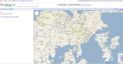
Google Maps Labs Rotated
A new prespective - Note the Map Labels (Text) are correct way up but the map is upsidedown.


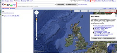
Google Maps Labs New
New Features and Tools in Google Maps via Google Maps Labs - Rotate Map Types (Sat

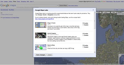
Google Labs experiments that you can now add the following functionality:

Drag 'n' Zoom
Zooming in on a specific part of the map is now fast and easy. Simply click the Drag 'n' Zoom button, draw a box on the map.
Google Maps Labs

Google Maps Labs Drag Zoom
New Button for Drag Zoom - Useful!

Click on the Green beaker New! to access the new features (simliar to gmail labs)

The Options are as follows
Aerial Imagery (Includes Rotate)
Add Aerial imagery to the map! Aerial imagery gives you rotatable, high-resolution overhead imagery presented in a new perspective. Currently imagery is only available in certain areas, but we're adding more all the time.

Back to Beta
Gmail isn't the only one that can enjoy a BETA tag.

Where in the World Game
Test your knowledge of world geography. Guess the name of the country from satellite imagery, and try to beat your top score.

Rotatable Maps
Tired of North always being up? Add rotatable map types and give East, West and South a fair go.

What's Around Here?
Adds a second search button that searches for "*", returning the top results in the current view. A great way to browse the map.

LatLng Tooltip
Displays a tooltip next to the mouse cursor showing the latlng directly underneath it.

LatLng Marker
Adds an option to the context menu that lets you drop a mini marker showing the latlng of the position that the cursor was pointing at when the context menu was evoked.

Smart Zoom
Ever zoom in too far and get the message "We don't have imagery at this zoom level"? Ensure you don't see it again, with Smart Zoom, which will check in advance what imagery exists, and ensure you can't zoom in beyond it.

source:
http://blogoscoped.com/archive/2010-02-12-n86.html
Related
http://googlemapsmania.blogspot.com/2010/02/google-maps-in-google-labs.html
Official Post
http://google-latlong.blogspot.com/2010/02/introducing-google-maps-labs-your.html

Labels: , , , , , ,

25 June 2009

Google City Tours (Labs)

Google City Tours (Labs)

Google City Tours Google Labs - London


Google Labs " Google City Tours" which uses Google Maps. The idea is that anyone can locate points of interest and plan up-to three day trips in major cities.

City Tours has a number of tours for pre-set for San Francisco, New York, London and Dublin. Major landmarks, museums and art galleries are available in each of the cities.


Landmarks can be edited on your own tour using the google map. Info windows display this information for the markers includes user rating and the opening hours. The Sidebar shows the order of the walk and the time it should take to walk from one location to the next.

City Tours Example - London Day 2
Mapperz Suggestion: The walking directions should follow the walkable path for the streets and not as the crow files in this case. Hopefully this gets an update.

Try it here
http://citytours.googlelabs.com
[Google account require to edit and save/rate tours]

Related post:
http://googlemapsmania.blogspot.com/

Labels: , , , , , , ,

28 May 2009

Brand New Google Maps API v3

Brand New Google Maps API v3 (in Labs)

Just released... and its even faster....lots of code changes...
Google Maps API version 3 - Brand New

"Welcome to the release of version 3 of the Google Maps API. This JavaScript API will look similar to the existing version 2 of the Google Maps API. However, much has changed under the hood: Version 3 (called V3 within this document) has been designed to load fast, especially on mobile browsers such as Android-based devices and the iPhone™. The initial launch has a smaller feature set than that available in the V2 API. We will migrate additional features from V2 while working to keep the size of the JavaScript code small and maintain our optimized loading speeds. We welcome your feedback and comments on this version of the Google Maps API within the Google Maps API V3 discussion group."


Major Changes:
  • No API keys required! so can embed in RSS readers
  • Geocoding API has been overhauled!
  • Model–view–controller (MVC) based - so faster downloading javascript!

example of code changes:

function initialize() {
var myOptions = {
zoom
: 4,
center
: new google.maps.LatLng(-33, 151),
navigationControl
= false,
scaleControl
: true,
mapTypeId
: google.maps.MapTypeId.ROADMAP
}
var map = new google.maps.Map(document.getElementById("map_canvas"),
myOptions
);

More Information:
http://code.google.com/apis/maps/documentation/v3/
Official Blog Post:
http://googlegeodevelopers.blogspot.com/2009/05/announcing-google-maps-api-v3.html

Labels: , , , , , ,

20 April 2009

Via Michelin Revamp (Maps, Routes & Photo's)

Via Michelin Revamp (Maps, Routes & Photo's)

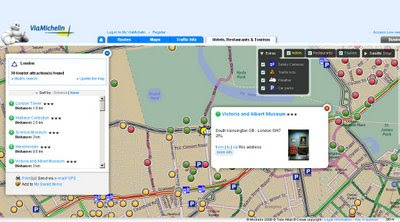
Via Michelin Maps Revamp - Points of Interest
Lot of new content availble in Via Michelin Maps - Speed Cameras, Traffic Incidents, Parking and Weather available across Europe.

Via Michelin Maps Revamp - Routing
Full routing (Directions) right across Europe - France to Turkey in this case.

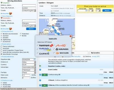
Via Michelin Send to GPS
GPS users can send themselves routes (directions) six different types are supported.
Note the good selection of alternative routes - sightseeing, economical quickest, shortest, pedestrian and bike.
Different types of automobiles (with caravan etc) and fuel cost calculator.
Display Hotels, Restaurant and Tourist site on-route.

Very impressive revamp from Via Michelin - the more you look the more there is with this site.

Via Michelin PhotoExplorer Labs (beta)
PhotoExplorer is currently in Labs (beta) with Via Michelin but looks familiar to the panorama layer google maps has (but it is Via Michelin own content).
more labs products:
http://labs.viamichelin.com/


Via Michelin is available in many more languages (Click the Flag Icon at anytime)
Native is French - http://www.viamichelin.fr/viamichelin/fra/tpl/hme/MaHomePage.htm

Labels: , , , , , ,

11 February 2009

Gmail gets location support

Gmail gets location support

Google Mail (Gmail) has now the ability via Google Mail Labs to add your location to your signature.
You have to enable experimental 'labs' (in gmail settings).

Gmail gets location support

Gmail signature location
Tick the 'Append your location' to activate the location factor.

Note: Google Gears (if installed) will ask for permissions to access your location (via ISP or Mobile/Cell network).

Gmail compose email signature with location

What No Map?
Request: A little Static Map that can be embedded into the email (if html)

like this:

Map Created with the Static Map Wizard

Source:
http://gmailblog.blogspot.com/2009/02/new-in-labs-add-your-location-to-your.html

Some other thoughts
http://searchengineland.com/gmail-labs-adds-location-to-signatures-16518
http://blogoscoped.com/archive/2009-02-11-n42.html

Labels: , , , , ,

30 January 2008

Nokia Beta Labs - Location Tagger

Nokia Location Tagger
(georeferencing your phone camera photos)

Nokia Location Tagger

"What is it all about? Nokia Location Tagger is a small application running on “selected” S60 3rd devices that allows you to tag pictures captured from Camera application with geographical coordinates from GPS. The tagging process itself is sometimes called geotagging or geocoding (see also this article at Wikipedia). Technically, the location information is stored in the EXIF header of your pictures (.jpg file)."

Nokia Location Tagger S60


With Nokia Location Tagger, you can automatically tag your location data to your pictures. As you take a picture, your GPS coordinates are saved to the EXIF header of the JPEG file. You can use this data later, for example, to locate your pictures on a map.
In the near future, we hope to make location tagging a seamlessly integrated part of your Nokia experience. Until then, Nokia Location Tagger is a small standalone application that gives you a sneak preview. We are not planning to productize this application as such, but we’d love to hear your thoughts already now, so that we have time to take it into account in the mainstream development.
Tested with Nokia N95, N95 8GB, N82, and E90 using the integrated GPS. Should work but not fully tested with all S60 3rd edition devices using an external Bluetooth GPS receiver. Sharing your location-tagged pictures online requires Share Online 3.0.

- Launch Nokia Location Tagger application.- On the main screen, you will see the status of your GPS module. It will show the coordinate if GPS module is active. Otherwise, it will show "Searching".- To tag pictures with GPS coordinates, simply use the built-in Camera application. Press the Camera button of your device to take pictures as usual. When Nokia Location Tagger is running in the background, you will see small icon at the top left corner of Camera’s view finder. This indicates the status of GPS module: Green: GPS module is active. Amber: Nokia Location Tagger is connecting to GPS module or searching for GPS coordinate. Red: GPS module is inactive.

Q: What happens if I take pictures while the GPS module is not active yet?

A: Nokia Location Tagger tries to tag pictures to the last "known" coordinates in the last 10 minutes. Since GPS module normally takes some time to initialize, it’s better to launch Camera application a couple of seconds before taking pictures. Launching Camera application will activate Nokia Location Tagger; which will initialize GPS module. You can also bring Nokia Location Tagger window to the foreground to initialize GPS module.


Q: Will my battery be empty very fast when running Nokia Location Tagger in the background?A: Nokia Location Tagger has a time-out feature (by default, it is 5 minutes). If there is no picture until time-out time, the GPS module will be turned off. This will normally save power. you can change the time-out option in the settings (2, 5 (default), or 10 minutes)

Q: How can I view the GPS coordinates of my pictures?A: The GPS coordinates are stored in the EXIF header of JPEG files. Some online sites, such as Flickr and Panoramio are able to display GPS coordinate from the EXIF. For more info on these services, please see below. You can also use photo organized software that read EXIF, such as Picasa (with the combination of Google Earth).
Q: How can I set Flickr to automatically import location in my uploaded pictures, and place them on a map accordingly?A: Please go to this URL: http://www.flickr.com/account/geo/exif, sign in, tick the yes please box and click save. From now on, all new tagged pictures that you upload will automatically be placed on a map. Also underneath every picture, there will be a map link that - after you click on it - shows where the picture is taken. Here are some examples. A nice alternative to Flickr is Panoramio. After uploading your pictures, you can view them on Google Maps but also export them to Google Earth. Here are some examples.
issues- The pictures from secondary camera are not tagged. Nokia Location Tagger tags pictures from the main camera only.- In a very rare case, Nokia Location Tagger may not be able to tag picture with the error message "File is being used".- Pictures captured in burst mode may not be displayed in order in the Logs tab.- This version has been tested on N95, N82, E90 as well as N73, N81 with external GPS module (Nokia LD-4W). It should work on all other devices; but there is no guarantee at this point.

What can we do with the Geo-tagged pictures? You can upload them to the photo sharing sites, such as Flickr, Panoramio and Picasa Web, so that your friends know where the pictures were taken. If you want to keep them private on your PC, some photo organizer applications, such as Picasa (combined with Google Earth), are able to display location information.
Please read the instructions at Nokia Location Tagger web page.

Labels: , , , , , ,