->

14 January 2010

Edmonton Opens Up City Data

Edmonton Opens Up City Data

The City of Edmonton in Alberta, Canada is following suit of Vancouver and Toronto and opening up city (public) data.

Data available now (more available after review of the community preview Feb 2010).
  • 2009 Census - Age and Gender
  • 2009 Census - Dwelling Unit Ownership
  • Bus Stops Edmonton Transit Locations
  • City Council Meeting Schedule
  • City Parks Locations of various City parks in Edmonton
  • Community League Centres Locations in Edmonton
  • Locations of all Fire stations in Edmonton
  • Locations of historical buildings in Edmonton
  • List of Planned Road Closures throughout the City of Edmonton
  • Police Stations Locations in Edmonton
  • Locations of School buildings in Edmonton

Though Edmonton take it a stage further and provide feeds and data overlay map ready so users can quickly make use of the data.
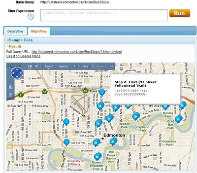
Edmonton Bing map
Default View of Bus Stops Overlay on the Edmonton City of Edmonton Website

Getting to the Data
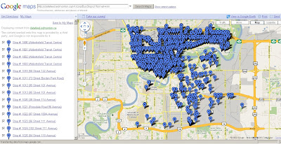
Edmonton KML
This example show the direct feed http://datafeed.edmonton.ca/v1/coe/BusStops/ as a KML (Google Earth) file loaded directly on Google Maps.
To view this Data as above - http://maps.google.com/?q=http://datafeed.edmonton.ca/v1/coe/BusStops/?format=kml

There is a stage futher, not only do City of Edmonton provide Scripts ready made so it makes it much easier for non programmers to create their own web maps.
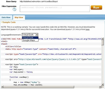
Edmonton bing map source
Default is Bing (Virtual Earth) Maps though drop-down Language Environment reveals Google Maps API source code.
Mapperz edited mashup
This a mapperz example taken from the code above. Though there are two important changes for the examples to work.
1. jquery-1.3.1.min.js needs to be fully mapped to your server/website
2.Google Maps API requires a specific API Key for YOUR site (API Key signup)

Other changes mapperz made are simply moving the latitude and longitude to centre on Edmonton and not Washington DC.

Links - and Well done to the City of Edmonton making this available.
http://data.edmonton.ca/

mapperz version (tweaked to work)
http://mapperz.googlepages.com/edmonton_google_map_source.html

source:
http://www.calgaryherald.com/Edmonton+releases+downloadable+databases/2438135/story.html

Labels: , , , , , , ,

25 June 2009

Google City Tours (Labs)

Google City Tours (Labs)

Google City Tours Google Labs - London


Google Labs " Google City Tours" which uses Google Maps. The idea is that anyone can locate points of interest and plan up-to three day trips in major cities.

City Tours has a number of tours for pre-set for San Francisco, New York, London and Dublin. Major landmarks, museums and art galleries are available in each of the cities.


Landmarks can be edited on your own tour using the google map. Info windows display this information for the markers includes user rating and the opening hours. The Sidebar shows the order of the walk and the time it should take to walk from one location to the next.

City Tours Example - London Day 2
Mapperz Suggestion: The walking directions should follow the walkable path for the streets and not as the crow files in this case. Hopefully this gets an update.

Try it here
http://citytours.googlelabs.com
[Google account require to edit and save/rate tours]

Related post:
http://googlemapsmania.blogspot.com/

Labels: , , , , , , ,

05 October 2007

Real-Time Travel Information Map - Leeds

Real-Time Travel Information Map - Leeds

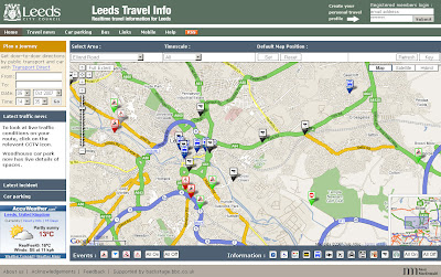
The Map shows the location of all traffic affecting Road Closures, Roadworks and Planned Events active now or in the near future.

Leeds Travel Information Map
An excellent 'mashup' using numerous data sources including BBC Backstage and Leeds City Council.

Tips on Use: If the map looks cluttered when you visit first use the content panel and switch off all then click individual icons for that layer to be displayed.
Also available is a set your last selected default map position and also remembers your last selection of travel information types and time.

Full Features of the Leeds Travel Information Map
  • Map: the map shows the locations of all traffic affected by road closures, roadworks and planned events that are active now or in the near future
  • Car Parking: A list of up to the minute information on car parking spaces
  • Travel News: This tab contains a searchable list of all traffic affecting road closures, roadworks and planned future events.
  • RSS Feeds: subscribing to the RSS feeds you can receive up to the minute travel information of your choice for the Leeds area
  • Mobile Services: live travel information to mobile phones with Google Maps for Mobile
More Information from the Help Guide
and for a Full Legend for the Map Icons go to the Key

Leeds Travel Information Map


More like this please! Mapperz

Labels: , , , , ,

11 September 2007

Embed Ask City Maps

Embed Ask City Maps

Ask City map now allows you to embed the maps into your blog/website similar to Google Maps.


Though 'Ask' has a clever function not seen before - searching within a polygon.

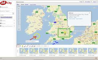
This map was to find Bourne Ultimatum films showing in cinemas in Greater London

How is this function achieved?
Draw a Polygon of the search area. (used the M25 as boundary)

Then when the polygon is completed (double click to close)
a little search magnifying glass appears.

Ask City Search by Shape

Clearly the Ask help is not updated with this

There is a some way to go, only a few results where returned. Looks like the bounding box was (map extent) was used rather than the actual polygon.
But a good step in the geographical spatial search method.

Real spatial searches in 'Search Engines' and web based maps? Maybe very soon.
A quick fast method would be to send the centre coordinates with a radius distance and use a spatial database (postgres is extremely powerful and fast at this) to return all the locations based on the search terms to give the user the first ten.
*postgres can do this in milliseconds.

Labels: , , , , ,

16 February 2007

Interactive Vancouver City Map

Interactive Vancouver City Map

Vancouver Map Interactive Overview
A very impressive interactive map for the city of Vancouver.
Nice layout and easy to use, user controls
Pan, Zoom in, Zoom out, Zoom Bar, Interactive layer controls, and useful Overview Map links with main map and legend when hovering over the sub layer.


Vancouver Map Interactive Layers
Switching layers on add content to the map, from accommodation to transportation (sky train).


Two useful functions:

zoom bar

The Zoom Bar allows for incremental zooming on the area visible on the screen. Users can either slide the zoom slider control to the desired zoom level, click on the + or - buttons on either side of the bar, or they can click on any space on the bar to adjust the zoom level accordingly.

mark tool

The Mark tool can be dragged from the top bar to any space on the map. You can customize the text accompanying the marker by clicking on the text. The symbol of the icon can also be adjusted to your desired size by clicking on the <> buttons near the icon. The map can then be printed with the customization in view. Customized marks will appear on the Menu, but will not be saved a browser window has closed or you have moved to a different map. You can delete the icon by clicking the X in the upper left corner.

More Help


Makes Mapperz want to visit.

Labels: , , ,

05 December 2006

Ask City Maps

New Ask City Maps
Ask City Maps UK

New Mapping from Ask.com and CitySearch
Drawing Tools make it easy to add graphics to the map point(icon), line (freehand available), polygons and text.

Good you can save snap shots of your cartographic skills (mapperz was playing!)

AskCity is a search service that allows you to find Businesses, Events, and Movies for most cities in the U.S. Ask combines these features with a number of other helpful services, such as:
  • Driving and walking directions
  • Drawing tools so you can mark places on your map and add text notes
  • Editorial and user reviews of local businesses, concert halls, movie theaters and more
  • Options that allow you to save one location while you search for another one on the same map
  • "Save Map" option that allows you to save up to ten of your maps
But also works in the UK, Road Classifications shows maximum speed for that Road.
(note speed limit in Richmond Park is 20mph now UK does not have a 25mph limit)

Ask Map Richmond Park Speed Classifications

To make your map click here

Labels: , , , , ,