->

21 January 2010

Big News - Nokia Ovi Maps Free for Life

Big News - Nokia Ovi Maps Free for Life

updated 5.07pm 21/01/2010
Nokia Ovi Maps Free for Life
No more subscriptions, Ovi Maps with Navigation (Walking, Driving) is now Free.
*N97 soon after firmware update release.
update N97 users: "New Ovi Maps for N97 will be available on 28th January 2010." with Maps v3.3 included in the firmware update.

note:some N97 users are confirming that the new ovi maps application will install when there is more than 20mb free space on the c: drive (untested by mapperz).

A New version of Ovi Maps 3.3 comes with FREE driving (car) & walking (pedestrian) features turn-by-turn, with voice guided navigation. Ovi Maps has a large global coverage.
74 countries are covered.
Maps Data for all the regions will be available, for free, for loading over the air (data costs!) or pre-loading via a desktop computer (PC or Mac). Traffic information and city guides from the likes of Lonely Planet and Michelin, will also be made available at no additional cost.

Since Nokia owns Navteq (the map data company) they can do this without losing out. So Google, tomtom and many others look out.

Press Release:January 21, 2010
Nokia makes walk and drive navigation free on its smartphones, doubling size of mobile navigation market
http://www.nokia.com/press/press-releases/showpressrelease?newsid=1375569

Video


Official Nokia Maps Website
http://maps.nokia.com/explore-services/ovi-maps/ovi-maps-main

Supported Devices for the Nokia Ovi Maps v3.3
http://europe.nokia.com/support/product-support/maps-support/compatibility-and-download#/default/

More Details at:
http://www.womworld.com/nokia/13158/your-thoughts-on-this-mornings-ovi-maps-announcement/
http://www.allaboutsymbian.com/news/item/11010_Nokias_Ovi_Maps_navigation_goe.php

News Links
PC World
http://www.pcworld.com/article/187335/nokia_delivers_free_navigation_service_to_customers.html

Engadget
http://www.engadget.com/2010/01/21/nokia-ovi-maps-with-free-turn-by-turn-navigation-hands-on/

BBC News
http://news.bbc.co.uk/1/hi/technology/8472165.stm

The Guardian
http://www.guardian.co.uk/technology/2010/jan/21/nokia-satnav-software

The Times Online
http://technology.timesonline.co.uk/tol/news/tech_and_web/article6996954.ece

Labels: , , , , , , ,

30 October 2009

Google Maps JavaScript API v3 - Now with Directions

Google Maps JavaScript API v3 - Now with Directions

**Remember Google Maps JavaScript API v3 is designed to be super lightweight for mobile devices

This makes mapping for mobile devices a lot more useful

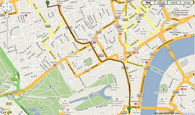
New Directions (Walking or Driving) in London - Google Maps API V3
New Directions (Walking or Driving) in London - Google Maps V3

@mapperz example above
http://mapperz.googlepages.com/google_mapv3_directions.html

With a Directions Panel
http://mapperz.googlepages.com/google_mapv3_directions_panel.html


Code:
New required parameters

var directionDisplay;
var directionsService = new google.maps.DirectionsService();

Set Start and End locations:

function calcRoute() {
var start = document.getElementById("start").value;
var end = document.getElementById("end").value;
var request = {
origin:start,
destination:end,

Travel Modes:

travelMode: google.maps.DirectionsTravelMode.WALKING
travelMode: google.maps.DirectionsTravelMode.DRIVING

Get the response from the Geocoder if both locations geocoded then display route between locations:

directionsService.route(request, function(response, status) {
if (status == google.maps.DirectionsStatus.OK) {
directionsDisplay.setDirections(response);


See the changelog
http://code.google.com/p/gmaps-api-issues/wiki/JavascriptMapsAPIv3Changelog

revelant links
Official documentation
http://code.google.com/apis/maps/documentation/v3/reference.html#DirectionsRenderer
http://code.google.com/apis/maps/documentation/v3/reference.html#DirectionsService

Offical Examples:
http://code.google.com/apis/maps/documentation/v3/examples/directions-simple.html
http://code.google.com/apis/maps/documentation/v3/examples/directions-panel.html

source:
http://groups.google.com/group/google-maps-js-api-v3/browse_thread/thread/ee7ce7cf8a872268?hl=en#

Labels: , , , , , ,

15 October 2009

Atlanta Mapathon - Creating the Best Mapped City

Atlanta, the capital of the US state of Georgia will soon be the world's most digitally mapped city, according to organisers of a massive "Mapathon".
Source: BBC News

OSM Map Altanta Mapathon

http://www.openstreetmap.org/index.html?lat=33.792&lon=-84.336&zoom=10

What is a Mapathon?
Mapping on-mass [crowdsourcing] the downtown Atlanta area including parks, university campuses and historic sites. Volunteers will be on hand to help new mappers learn how to use a GPS or Walking-Papers and have helpful tips for beginners. Come for the whole day or just stop by for an hour to learn the basics of community mapping and add a few points of interest to the map.

Atlanta Citywide Mapathon

October 16th 17th 18th

During this three day mapping event, local businesses, community groups and OSM members will join together to launch a citywide initiative to help make the map of Atlanta one of the best in the US. For details of how to get involved in this fun, family-friendly event, see the Atlanta Citywide Mapathon page.

Useful links:
http://wiki.openstreetmap.org/wiki/Atlanta_Citywide_Mapathon
http://wiki.openstreetmap.org/wiki/Atlanta#Atlanta_Citywide_Mapathon

New to OpenStreetMapping?
http://wiki.openstreetmap.org/wiki/Beginners%27_Guide

Labels: , , , , , , , ,

31 July 2009

Free Ordnance Survey Maps for the iPhone

Free Ordnance Survey Maps for the iPhone

iOSMaps v1.0 has launched.
"Get the OpenSpace Ordnance Survey© mapping application for the iPod Touch© and iPhone© from the iTunes© Store for FREE right now!"

"The application is intended to be free, making use of newish technologies to showcase the awesome possibilities/fun of marrying different technologies. I see iOSMaps being used in replacement of paper Ordnance Survey maps. For what every your outdoor pursuit, be it mountaineering, skiing, fell running, hiking, cycling or a good old fashioned walk, just enjoy using the application on your iPhone"
Author of this application

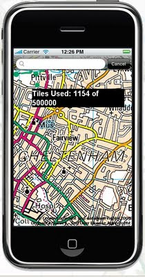
What is looks like on screen? (minus the tile number)

Free OS Maps iPhone
This service is not the fastest, but does work well, though you will find high data transfers costs using this service. But the idea is right, if caching of data is allowed on the phone in theory the user can 'cache os maps' before they venture out with the device.

iOSMap uses the new the mapping data provided by the OpenSpace API from Ordnance Survey, to show feature rich geographic, geotopic and cartalogic data of Great Britain. The application make use of OpenLayers, gmaps and prototype libraries and was written using the mighty iPhone sdk in Objective-C 2.0 and C.

Geeky info:
client:
iPhone/iPod Touch.

OpenLayers:Map,Control,GridProjection
OpenSpace 0.72:Map, Gazetter, GridProjection
Prototype1.6:prototype.js, scriptalicios.js
Google:gMapsAjaxSearch, googlemaps (check terms of use using google maps api and openspace api together?)

But very promising and will be the future of mapping, though not sure it will replace paper/book maps as they never run out of batteries...
Mapperz

To get the free OS Maps App on the iPhone website is:
http://www.publicfootpaths.com/

Labels: , , , , , , ,

25 June 2009

Google City Tours (Labs)

Google City Tours (Labs)

Google City Tours Google Labs - London


Google Labs " Google City Tours" which uses Google Maps. The idea is that anyone can locate points of interest and plan up-to three day trips in major cities.

City Tours has a number of tours for pre-set for San Francisco, New York, London and Dublin. Major landmarks, museums and art galleries are available in each of the cities.


Landmarks can be edited on your own tour using the google map. Info windows display this information for the markers includes user rating and the opening hours. The Sidebar shows the order of the walk and the time it should take to walk from one location to the next.

City Tours Example - London Day 2
Mapperz Suggestion: The walking directions should follow the walkable path for the streets and not as the crow files in this case. Hopefully this gets an update.

Try it here
http://citytours.googlelabs.com
[Google account require to edit and save/rate tours]

Related post:
http://googlemapsmania.blogspot.com/

Labels: , , , , , , ,

18 June 2009

Sustrans Map - Measure Your Route

Sustrans Map - Measure Your Route

"Sustrans is the UK's leading sustainable transport charity. Our vision is a world in which people choose to travel in ways that benefit their health and the environment. Every day we are working on practical, innovative ways of dealing with the transport challenges that affect us all."

Sustrans Map

The Sustrans Map uses Openlayers and data from Ordnance Survey - a Dotted Eyes creation.

Sustrans aims are:

  • reduce the environmental and resource impacts of transport
  • enable people to choose active travel more often
  • provide car-free access to essential local services
  • create streets and public spaces into places for people to enjoy.
The Unique 'Value Added Tool' for this map is the Interactive Route Creation which dynamically shows the user the distance and time it takes whilst digitising your own route:

Sustrans Map Measure Route
Custom route creation - displays average time and distance as you build your route.

The refresh display speed of the background maps are not the fastest but the usefulness of the tool overrides this bottleneck.

Link to Sustrans Birmingham Map (as above though zoom in)
http://www.sustrans.org.uk/map?searchtype=search&searchkey=Birmingham

Labels: , , , , ,

03 June 2009

Bing Maps for Mobile (with directions)

Bing Maps for Mobile (with directions)

related update: Just released!
Bing Maps 3D -
http://tinyurl.com/Bing-Maps-3D
(though it is/was the same as Virtual Earth plugin just renamed)
source:
http://www.microsoftwindowsos.com/bing-maps-3d-has-been-released


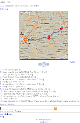
Bing Maps for Mobile (Cell) Phone is now available with Driving Directions and Walking Directions.

Bing Maps for Mobile Devices
Clean and Simple -Very fast response for Mobile devices.


There seems to be a neat function that it takes traffic information and applies it to the outcome or at least a warning of possible delays.

It is possible to test this function on a normal web browser

Other features are available (weather, local information etc.) from http://m.bing.com/

here is the link

http://tinyurl.com/BingMapsMobile

Labels: , , , , , ,

13 August 2008

Google Maps API - Walking Directions

update - from The Google Maps API Team

"This is the testing version of the Maps API JS, is not meant for production, and is liable to change at any time. Only use it for your personal experiments, and don't be surprised if it breaks later."


Google Maps API - Walking Directions
New!
Google Maps API Walking Directions New
Previously only 'Walking Directions' was available in Google Maps - Now available to be customised in the Google Maps API.

Try Mapperz version
http://mapperz.googlepages.com/Google_Maps_API_Walking_Directions.html


Thanks to Mike Williams with his useful and informative posts (usually with an example or two) on the Google Maps API Group with Version changes to the API. Walking Directions is made available in version *v2.124.


*Warning v2.124 is still subject to change.

source:
http://groups.google.com/group/Google-Maps-API/browse_thread/thread/0a12fef4439790cf#

v2.124 adds walking and avoid highways routing to the API.

The new GDirectionsOptions are:
{travelMode:G_TRAVEL_MODE_WALKING}
{avoidHighways:true}

The defaults are
{travelMode:G_TRAVEL_MODE_DRIVING}
{avoidHighways:false}

Example: http://econym2.googlepages.com/temp_walk.htm

Note: API v2.124 is not yet live. It's possible that the code may be
changed before it goes live.

Labels: , , , ,

22 July 2008

Walking Directions 'Beta' Now in Google Maps

Walking Directions Beta Now in Google Maps

Update:
'Walking Directions' option will appear when directions that are 6.2 miles (10 kilometers) or less.

Update2 - Mibazaar via Google Maps Mania finds a long detour.A 2 mile walk is now '120 mi (193 km) – about 1 day 15 hours'
http://maps.google.com/maps?f=d&hl=en&geocode=&saddr=detroit,mi&daddr=Windsor,+Essex,+Ontario,+Canada&mra=cc&dirflg=w&doflg=ptm&sll=42.482226,-82.692719&sspn=0.474992,0.85144&ie=UTF8&t=h&z=10
So Beta it is...


Google Maps Directions Car Mode
Traditional Driving Directions take you around Hyde Park, London
Map Directions (Car)
Longer Distance (3 miles but shorter time for the journey 12 mins)
**
(excludes finding parking, pay for parking and sitting in traffic waiting for parking)

Google Maps Directions Walk Mode
Switching to 'Walking' Beta Mode shows it's much shorter to Walk than Driving taking only 8 minutes longer than Driving .
Map Directions (Walking)
Shorter Distance (1 mile for the journey but 20 minutes in duration)
***
Use caution when walking in unfamiliar areas.

Official Blog Post

Labels: , , ,