->

20 April 2011

Ovi Maps 3D Beta (Now Photorealistic)

Ovi Maps 3D Beta ( Now Photo-realistic)


Cities coverage

Nokia's photorealistic 3D models of metropolitan areas initially include:

- Barcelona
- Boston
- Chicago
- London
- Copenhagen
- Florence
- Helsinki
- Las Vegas
- Los Angeles
- Madrid
- Miami
- Milan
- New York
- Oslo
- Prague
- San Francisco
- Stockholm
- Toronto
- Venice
- Vienna

http://maps.ovi.com/3d/
(plugin required) - servers are in demand currently and might not get the full picture - wait a few days for the hype to calm down.

http://conversations.nokia.com/2011/04/19/ovi-maps-3d-the-world-is-not-flat/

Labels: , , , , ,

12 August 2010

Sports Tracker 3.5 Released

Sports Tracker 3.5 Released

Sports Tracker
The Award winning FREE Sports Tracker Application gets an update along with revamped web service for viewing and sharing your routes.

"The newly launched online service allows users to store, visualize and analyze their workouts with enhanced tools, as well as share their media enhanced workout experiences with other Sports Tracker users - and the whole world. The online service also allows existing Nokia Sports Tracker Beta users to import their workout history to the new service.

The Sports Tracker mobile application has also been updated to support uploading of tracked data to the new service and direct sharing to Facebook. The update also extends the list of compatible devices to cover more than 50 device models."

Testing the New Sports Tracker:
Sports Tracker 3.50 Mapping GPS Routes
Mapperz has tested this and the services along with the phone application works seamlessly together.

With the FREE Sports Tracker application mobile phone becomes a full-featured GPS sports computer, keeping track of everything from calories burned while running to your average cycling speed over altitude. You get maps, time and distance calculators, step count, and even heart rate when you use a compatible Polar HR belt. You can chart your progress, find your strengths and weaknesses, and share with others.

The new mobile application allows users to:
  • Record activities with all the data needed to analyze the performance, including distance, speed, duration, route, step count and more.
  • Check their location on the map while running, cycling, walking or with any other outdoor activity, using Open Street Map as a map based (can be cached for offline use)
  • Upload their activity data from their phone to the Sports Tracker service
  • Share their activities and automatically geo-tagged photos with other users and friends on Facebook, directly from their phone
  • Optional with Heart Monitor - Record heart rate data by connecting the Polar WearLink®+ transmitter with Bluetooth® heart rate belt by Polar (€70 or $90USD)
  • Automatically compare speed, distance and duration of recorded activities


Get it here:
http://www.sports-tracker.com/

With this Launch Ovi (Nokia) are having a competition:


GPS Trace from Skating
Create your own shape and enter for a prize. Image: Ovi Blog

"What we’re asking you to do is simply this: make a funny or interesting shape with your Sports Tracker workout, share it publicly in the service and send a link of the shared workout to us."
For more information on this competition and what can be won go here:
http://blog.ovi.com/2010/08/12/sports-tracker-ovi-competition-launches-now

Labels: , , , , , ,

21 January 2010

Big News - Nokia Ovi Maps Free for Life

Big News - Nokia Ovi Maps Free for Life

updated 5.07pm 21/01/2010
Nokia Ovi Maps Free for Life
No more subscriptions, Ovi Maps with Navigation (Walking, Driving) is now Free.
*N97 soon after firmware update release.
update N97 users: "New Ovi Maps for N97 will be available on 28th January 2010." with Maps v3.3 included in the firmware update.

note:some N97 users are confirming that the new ovi maps application will install when there is more than 20mb free space on the c: drive (untested by mapperz).

A New version of Ovi Maps 3.3 comes with FREE driving (car) & walking (pedestrian) features turn-by-turn, with voice guided navigation. Ovi Maps has a large global coverage.
74 countries are covered.
Maps Data for all the regions will be available, for free, for loading over the air (data costs!) or pre-loading via a desktop computer (PC or Mac). Traffic information and city guides from the likes of Lonely Planet and Michelin, will also be made available at no additional cost.

Since Nokia owns Navteq (the map data company) they can do this without losing out. So Google, tomtom and many others look out.

Press Release:January 21, 2010
Nokia makes walk and drive navigation free on its smartphones, doubling size of mobile navigation market
http://www.nokia.com/press/press-releases/showpressrelease?newsid=1375569

Video


Official Nokia Maps Website
http://maps.nokia.com/explore-services/ovi-maps/ovi-maps-main

Supported Devices for the Nokia Ovi Maps v3.3
http://europe.nokia.com/support/product-support/maps-support/compatibility-and-download#/default/

More Details at:
http://www.womworld.com/nokia/13158/your-thoughts-on-this-mornings-ovi-maps-announcement/
http://www.allaboutsymbian.com/news/item/11010_Nokias_Ovi_Maps_navigation_goe.php

News Links
PC World
http://www.pcworld.com/article/187335/nokia_delivers_free_navigation_service_to_customers.html

Engadget
http://www.engadget.com/2010/01/21/nokia-ovi-maps-with-free-turn-by-turn-navigation-hands-on/

BBC News
http://news.bbc.co.uk/1/hi/technology/8472165.stm

The Guardian
http://www.guardian.co.uk/technology/2010/jan/21/nokia-satnav-software

The Times Online
http://technology.timesonline.co.uk/tol/news/tech_and_web/article6996954.ece

Labels: , , , , , , ,

08 January 2010

Ovi Maps Racing - Sneak Peak

What happens when you combine Ovi Maps and Ovi Games? Ovi Maps Racing is what happens – another gaming title announced today by Nokia, coming soon to the Ovi Store.

Ovi Maps Racing


"In a truly unique experience, you use the GPS in your device to find your location or use Ovi Maps to choose any location in the world), then customize a track around your neighborhood, and finally fire up those engines."


useful? or just fun... you decide.

Labels: , , , , , ,

22 October 2009

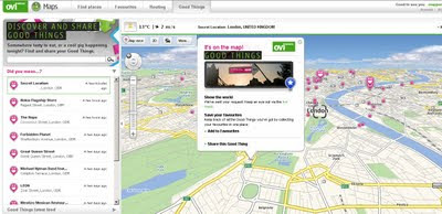
Nokia - Ovi Good Things

Nokia - Ovi Good Things

Nokia - Ovi Good Things
http://maps.ovi.com/goodthings/f84c5631-eec4-4ee6-8c04-872622dc1cb0/Secret-Location

(that's the location but you need a special token)

Labels: , , , , ,

08 September 2009

Ovi SDK - Map Beta Examples - First Look

Ovi SDK - Map Beta Examples - First Look

It is nearly a week since the public release of the Ovi [Nokia] SDK

Mapping Wise what can you do with it?

Ovi Map Example Apps
Well the first version had an issue - apps would not show, but this has been rectified and now the examples will show in the Nokia(N97) Emulator.

This example shows a few options.
Drop Pin
POI Icons
Server Icon (Wifi/3G connection required)
Local (Phone memory in the app)
Polyline (now we are getting somewhere)
Polygons - Reviewed
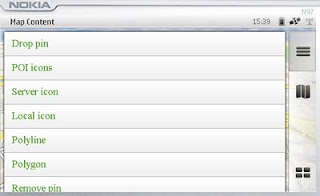
Map Content Example
Landscape mode enabled - shows all example with out needing to scroll.

Polygon Example

mapperz wasn't happy with the example polygon - it didn't seem that helpful

Ovi Maps Beta Example Polygon Bristol,UK
Custom Polygon generated in Ovi Map Player using the Ovi Apps SDK
(mapperz customised the orginal example with something slightly better)
So how was this achieved?

Well you can study the Development Guide or the API Library that comes zipped up
However the fastest way to learn is working examples

The code was found in mapfunctions.js
(in the Downloaded SDK >com.nokia.maps.examples.mapContent)
in here there is a section of code:

Example – Adding a Polygon to the Map
*/
function addPolygon()
{
var polygon = {
type: "polygon",
points:
[{latitude: 51.45128846597743, longitude: -2.5956809520721436}, {latitude: 51.45115474591054, longitude: -2.5934386253356934}, {latitude: 51.44976403399727, longitude: -2.5936853885650635}, {latitude: 51.449957933872724, longitude: -2.595916986465454}],
visible: true,
width: 5,
color: {red: 180, blue: 20, green: 0, alpha: 255},
fillColor: {red: 0, blue: 0, green: 0, alpha: 100}
};
// Set zoom level
player.map.setZoomScale(500);

// Move map center to a central location between the three points of the polygon:
player.map.moveTo({
latitude: 51.45052625634988,
longitude: -2.5947046279907227
});

// Create a layer:
//var layer = player.map.createLayer({name: "testLayer1"});

// Add the polygon:
var mapObjects1 = layer.addMapObjects(polygon);

}


all that code for one square polygon? well yes...

Now in real-world terms you need quite a lot of information before you start:
Coordinates for each vertices is required to have
{latitude: 51.45128846597743, longitude: -2.5956809520721436}
easier would be: {lat1:
51.451288,lng:-2.595680}
but it would be simpler to list them in a clockwise order.
or you end up copying and pasting lots of coordinates for quite simple shapes.

**note make sure you use {} 'curly brackets' and not () 'normal brackets' or you will get javascript errors.

There is currently no option for holes in polygons (donut polygons)
What would really help is the ability to overlay KML/GPX files from servers or accessed from the device.

Not sure why zoom extent coordinates are required - would be easier for the extent of the polygon(s) to be used.

Less code makes faster devices (http://www.bewebmaster.com/42.php)
color: {red: 180, blue: 20, green: 0, alpha: 255},
fillColor: {red: 0, blue: 0, green: 0, alpha: 100}

how about:
rgb:180,20,0,255
fill:0,0,0,100


Was hoping to evaulate the New Ovi Maps Navigiation API though in reading the documentation you get a message:

NOTE: The functionality described here is not yet available.

Would prefer they left it out until it was available - would presume that this requires an api key of sorts - but if wanted it tested and de-bugged in beta you would think it would be.


There is demand for this - many, many mobile devices are geo-aware and can use this but it seems clearer there is going to be a good few months of re-writting code to make this a truely customisatable portable mapping and navigational system.
Mapperz will review when activated.

The SDK has been written by techinical people and it does show. They say you are required some basic knowledge of html & javascript.
Mapperz would say you are required to be at an intermediate level for javascript, html,css and de-bugging.
Note: The Software Aptana 1.5 is required to do serious work in the Ovi Apps SDK.

Nokia have the resources they just need to apply it a little stronger.
Web Documentation would be also helpful - like many other mapping apis available.

So the answer to their blog
"OviSDK+you=Ovi Apps for Everyone"
http://blog.ovi.com/2009/09/03/ovi-sdk-you-ovi-apps-for-everyone/?utm_source=rss&utm_medium=rss&utm_campaign=ovi-sdk-you-ovi-apps-for-everyone

is no currently and unfortunately (hope this changes)

Action please
Nokia need people with basic programming - to read their documentation and highlight areas of explanation.

Ovi Maps Player API stongest competitor is going to be Google Map API (v3) There are some interesting features coming to it in the coming weeks, stay tuned.

When these teething issues have been ironed out then they will have a competitive product.
There is no indication whether the Navigation API will require a licence.
Currently Nokia Ovi Map users require a daily,weekly,monthly or yearly licence to use Navigational Features, if you make an app with it - does everyone require a seperate licence.
If they do it will be a stumbling block for a promising feature.

Labels: , , , , , , , ,

03 September 2009

Ovi Maps News

Ovi Maps News
Nokia have released/updated some Ovi Apps Products

Of Mapping interest there are:

Developers that register for the programme will have access to the following:

  • Ovi Maps Player API – Bringing maps to mobile and web applications effortlessly. The API is powered by NAVTEQ and features more than 180 country maps, location-based search, and detailed place information. Other features include vector-based maps that give a range of views, including: map, terrain and 3D modes for dynamic map mash-ups. The Ovi Maps Player API for the web was introduced earlier this year.
  • Ovi Navigation Player API - Allowing developers to bring Nokia’s industry-leading walk and drive navigation features to their applications, including: pedestrian navigation, turn-by-turn car navigation, and route planning. Developers can deliver applications that get consumers exactly where they want to go.

Ovi Maps Player Example

"Introducing Maps Player - the brand-new, easy-to-use API for Ovi Maps. Maps Player makes it simple to integrate rich Ovi Maps functionality into your website, turning it into a personalised, contextual and compelling experience. "

here is one example

Ovi Maps Player POI

Unlike other Mapping API's available - [Nokia] Ovi Maps Player API gives developers access to their Point's of Interest (currently 3 million) Database.

POI Categories are:

"AMUSEMENT_PARK", "BARS_CAFES", "BAR_DISCO",
"BEACH", "CAMPING", "CAR_DEALER",
"CAR_REPAIR", "CASH_DISPENSER", "CASINO",
"CINEMA", "COMPANY", "CONCERT_HALL",
"CULTURAL_CENTRE", "EDUCATION", "EXHIBITION_CENTRE",
"GOLF_COURSE", "HOLIDAY_PARK", "HOTEL",
"LIBRARY", "MUSEUM", "OPERA",
"PARKING", "PARKING_AREA", "PARKING_GARAGE",

"PARK_RECREATION", "PETROL_STATION", "PHARMACY",
"PLACE_OF_WORSHIP", "POST_OFFICE", "RENT_A_CAR_FACILITY",
"RESTAURANT", "REST_AREA", "SHOP",
"SHOPPING_CENTRE", "SPORT_OUTDOOR", "STADIUM",
"THEATRE", "TOURIST_ATTRACTION", "TOURIST_INFORMATION_CENTRE",
"UNIVERSITY", "ZOO"

Live Example:

Note: you cannot copy & paste the source code unless you have signed up to Ovi Maps Player API (beta) and have recieved 2 api keys from Nokia for specific domains

** For 3D view an Ovi Map Plugin is required and you will require a restart of you web browser.

http://maptile.svc.nokia.com.edgesuite.net/players/map/noauth/examples/Map_Player_moveToObjs.html

More Information Link:

http://www.allaboutsymbian.com/news/item/10415_Ovi_Maps_opens_up_to_devlopers.php
video:

Ovi Navigation API
Ovi Maps Navigation Player API gives you access to the industry-leading Ovi Maps Walk and Drive navigation service, powered by NAVTEQ [Nokia Owned]. With just a few lines of JavaScript, you can add turn-by-turn pedestrian or car navigation to your Ovi apps. You can also add routing to your websites.
Ovi Navigation API
Ovi Navigation API - Drive, Walk & Cycle 'turn-by-turn' directions

Advanced vector maps allow routes matched to the needs of drivers and pedestrians – even when your users are offline.

Developers will be able to use simple, high-level interfaces to leverage turn-by-turn Walk and Drive navigation, with voice guidance in over 20 languages

Users are tired of seeing car routes recycled as "pedestrian". Give them a real Walk experience, with custom map display and enhanced DiscoverCities Navteq data.

Quick links:
http://www.forum.nokia.com/Ovi/
http://www.slashgear.com/nokia-ovi-sdk-plus-navigation-and-maps-apis-launched-0354940/

Source: @Mapperz

Labels: , , , , , , ,

15 June 2009

Nokia N97, Ovi Maps - The Mapperz Review

Nokia N97 Ovi Maps Review

"Ovi Maps is the new name for Nokia Maps."
Nokia have updated their mapping application.
Some good improvements and new content and new features and simpler cost structure.

Deleting Outdated Map Data
Old map data is recognised in the new software and will update the data, though depending on the amount of coverage you choose. Total for the entire world is towards 7GB. The UK is 156.5mb.
Pre-loading the maps will save you money in
'data transfer' costs over the mobile networks.

New Nokia Ovi Maps
Nokia Maps now Ovi Maps was updated last Thursday (11/06/09)

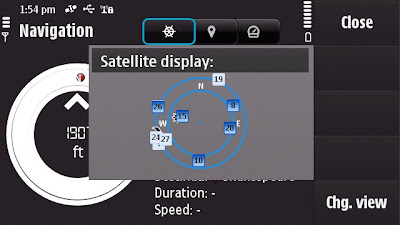
Satellite Status - BarSatellite Status - Radial
A quick note: Getting GPS Fixes faster. (less than a minute with 5 satellites
using standard GPS - no network based or A-GPS which uses the mobile
network to access GPS positional data)

The New N97 has more GPS details - in Applications>Location you can find
this in Position options Satellite Status will give you the signal strength of all
the GPS satellites available.
The view can be changed to Satellite display that gives the orbits on a radial
chart with sun and moon positions also. A nice feature, could this be implemented
in the Ovi Maps Application on the phone?

Back to the Maps:

What is New?
  • The map (vector) data has been completely updated
  • Current weather forecast information.
  • Speed Limit Warner
  • Saftey Spot Warner
  • Travel time or Time of Arrival option
  • Automatic 'Re-route' due to traffic option
  • Walking Directions has the option of straight-line distance to the destination.
  • Automatic 'Day/Night Time' Map mode.
  • Maps Improvement option.
  • *Compass mode (N97) Map rotates with you touch dragging (pan & zoom)
  • Search Nearby - vastly improved and more details available to users
  • Synchronisation with Ovi Maps Online. (confirmed this works very well)
  • Performance has been much improved (panning the map)
  • bugs fixed and is now a more stable application.
  • Better support and help - on phone or online option
Compass requires calibration before the function is available to use.


Traffic Information is now displayed on the Map even in 3D mode - Routes can be
automatic recalculated to avoid traffic incidents.

Smoothness, there has been a big improvement in the panning and zoom,
no jittering - when in driving navigating the map keeps up with the speed
of the vehicle. Navigation does repeat 3 times, one for advanced warning
- 350 yards. Then reminders at 50-30yds then 10 yards.

Walking mode does have the addition of straight line
'as the crow flies'
direction and distance.
(Golf players might use this to their advantage.)
Note the compass is 'green' meaning it is calibrated and active giving the
user the sense of bearing.
Walking Mode Straight line Navigation

Details on the map data:
v3.01 09wk24 b01 MV OpenGL LM MN
Map Version 0.1.22.103 OpenbitLM 6.21.3

Data souces:
NavInfo (Traffic info)
Satellite Imagemap 2002 - Planetary Visions
Imagery - Digital Global 2008
Aronbado por el Insitututo Geografico Milltar 5 Sept 2008.
STRM V4 2008 CIAT

update 25th January 2010 - New devices N97 (June 2009 onwards) Navigation is now Free
for life of the Phone. see
http://maps.nokia.com/explore-services/ovi-maps/downloads#/default/
Costs: (based on UK prices) - For Directions and Voice Navigation.
£52.99 for a year.(covers Europe).
£6.00 for 30 days.
£1.50 per day
*Pricing for other regions vary

1. Bug found: When using the 3D map option on the N97 - the touch screen only pans
upwards, the user cannot pan down the map.

Overall impressed with Nokia Ovi Maps 3 and where this application is going,
not only improving the software, the map data but introducing new and useful
features that engage and interacts with the user getting them to and from
locations conveniently.
Also the maps (vector data from Navteq now Nokia owned) are more up-to-date
than many online mapping
sources including TeleAtlas etc. (which Google uses).
At least areas that Mapperz has tested in so far.

This is the final beta stage of Ovi maps version 3. Expect the full release
in the next few weeks for
all current nokia phones that can support the application.

SportTracker Users will be happy to know that this is working for the N97 with
the touch screen controls.
Please visit Symbian World for more on this:
http://symbianworld.org/1187-sports-tracker-finally-
available-for-nokia-n97-and-5800/

Ovi Maps is a free application for S60 devices, though extra features
'Directions and Voice Navigation'
require licences that can be purchased
through the application.
More information
http://betalabs.nokia.com/betas/view/nokia-maps-30-maps-ovi

More details on the N97 Mapperz recommends:
http://www.allaboutsymbian.com/reviews/item/Nokia_N97
_Review-Part_1-First_impressions.php

http://www.allaboutsymbian.com/news/item/9902_Nokia_N97
_Review-Part_2-Touch-.php

A very special thanks to the team at http://www.womworld.com/nokia/
for a very successful 'Search for N' competition.


Labels: , , , , , , , , ,

10 February 2009

Nokia Maps v3.0 updated (including ovi maps)

Nokia Maps v3.0 updated (including ovi maps)

Nokia Maps v3.0 Updated
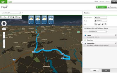
Nokia Ovi Maps (web browser) now can save routes and sync with your nokia maps v3 - mobile/cell device (sign in required to save routes) - Map in nighttime mode with weather and route.
  • You can rotate the map and view 3D landmarks from all directions.
  • In 3D view mode, you can tilt the view by pressing 2 and 8 button
  • 2D/3D mode works with all map modes, now with Satellite and Terrain
  • My Places has option "Point me to" for any saved place/landmark saves the viewing angle as well.
  • Synchronisation of Favourites and Collections with Ovi Maps and vice versa (use in online mode, enable Internet connection), you can now plan routings on Ovi Maps and synchronise to your device
Compatibility and system requirements
Maps Updater and Map Loader 3.0 require Microsoft Windows XP or Vista.
Maps Updater requires Nokia PC Suite to be installed on your computer.

Maps 3.0 Beta works with Nokia devices based on:
S60 3rd Edition Feature Pack 1 (E71, E66, 6110 Navigator, N95, N95 8GB, N82)
S60 3rd Edition Feature Pack 2 (N96, N85, N79, 6650, 6210 Navigator, 6220 Classic, N78)

Ovi MapsBeta works on IE6 (Windows XP), IE7, Firefox 2 and Firefox 3 (Windows XP or Vista).

Note: you cannot use the Nokia Maps 2 and Nokia Maps 3 on the same device. If you have a license for sat-nav (directions/traffic updates etc) you might lose your full licence.
Backup your device before trying beta software.

"Your travel guide licences are not valid in the beta version of Maps 3.0. However, the guide licences will be valid again in the final version of Maps 3.0."

Future implementations (commercial release)
  • Safety spot warner's in selected countries
  • Extended country coverage for Traffic info service
  • Weather information
  • Premium POI content for travel, selected events and cinema
http://betalabs.nokia.com/betas/view/nokia-maps-30-ovi-maps

source and many more screenshots:
http://www.allaboutsymbian.com/news/item/8921_Nokia_Maps_30_beta_updated.php

Labels: , , , , ,

02 December 2008

Nokia Maps 3.0 (beta) - New! +Ovi Maps

Update: WOM World have just sent Mapperz a Nokia Nokia 6210 Navigator for testing the New Maps out.

Will do a honest roundup of the new map application with the next week or so.
[Thanks to WOM World for that surprise and the link]

Nokia Maps 3.0 (beta)
- New!

Nokia Maps 3.0 - New Features
3D Buildings, New Terrain Mode, and Faster... Nokia Maps 3.0 (beta)

Nokia are having a large launch of many mapping apps and plugins:

updates will follow...

Important bit of info:

"Finally some words about compatibility. Right now the Maps 3.0 beta is available only for Nokia devices based on S60 3rd Edition Feature Pack 2, but we haven’t forgotten the FP1 users either. The version for you will follow soon. Also we’ve seen compatibility issues with N96, so we don’t recommend using Maps 3.0 beta with it just yet. In Maps 3.0 beta old Maps 2.0 licenses are supported, so if you have Walk or Drive licenses on your device, they will continue working also after the update."

* What’s new: Enhanced car navigation, Drive*, through lane assistance, speed limit warners, improved sign post design and new ‘Route overview’ mode during navigation,
* Enhanced pedestrian navigation, Walk**, through shortcuts (virtual connections) in urban areas, straight line guidance for off-road terrain and beeps and vibrations before next turn,
* Significantly improved map data quality and content,
* 3D landmarks for over 200 cities – can be displayed in 3D and 2D map modes,
* New Terrain*** map mode,
* Hi-res aerial images for Satellite*** and Hybrid*** map modes,
* Nokia Maps Updater for PC, to update your Maps application and existing map data,
* Synchronisation of Favourites and Collections with MapsBeta on Ovi and vice versa (use in online mode, enable Internet connection).

# Coming soon in Maps 3.0 commercial release: Safety spot warners in selected countries
# Extended country coverage for Traffic info service
# Weather information
# Premium POI content for travel, selected events and cinemas


More info from
http://www.allaboutsymbian.com/news/item/8588_New_Nokia_Maps_plus_personalis.php

# Coming soon in the next Beta release: Route planner for Drive, car navigation, and Walk, pedestrian navigation,
# Traffic information,
# Weather information.

Download available from here

http://www.nokia.com/betalabs/maps/

Nokia maps comes to the Web Browser (plugin required)

Ovi Nokia Maps in IE8 Browser
You can now view Nokia Maps in Full Screen on your PC - The Plugin is available for IE and FireFox. (Shown here in IE8)

Plugin download from
http://maps.ovi.com/services/integrated

Labels: , , , , , , , ,

29 August 2007

Ovi Nokia Maps Released

Ovi Nokia Maps Released for All - (Out of Beta!)

Nokia Maps Released

"London, UK – Nokia today introduced Ovi, the company’s new Internet services brand name. With the
introduction of Ovi, Nokia is expanding from a focus on mobile devices to offering a range of Internet services. Ovi, meaning ‘door’ in Finnish, enables consumers to easily access their existing social network, communities and content, as well as acting as a gateway to Nokia services."

Ovi Nokia consists of:
  • Nokia Music Store
  • N-Gage
  • Nokia Maps
  • *(more to be added)

Also under the Ovi umbrella is Nokia Maps, a navigation service that offers maps, city guides and more directly to compatible mobile devices. Nokia aims to bring more Internet based services to Ovi in the coming months.

Give me the links!

http://europe.nokia.com/A4509271 - Nokia Maps/Device Selector

http://europe.nokia.com/A4509291 - Introduction and how it works

http://ovi.nokia.com/ovi/flash/assets/

pdf/1_MeetOvi_Umbrella.pdf - Press Release (PDF)

http://nds1.nokia.com/files/support/global/phones/
guides/Maps_1_UG_en.pdf
User Guide (PDF)

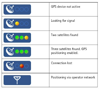
Nokia Maps GPS Fixes
GPS Fixes - the bottom icon costs you money with data transfer - Assisted GPS enabled (N95) only

Mapperz

Labels: , , , , , ,