->

18 August 2011

Google Maps World Weather

Google Maps World Weather

Google Maps World Weather
Work in°C | °F or km/h | mph | m/s with the additional option to overlay clouds

Works well.

http://maps.google.com/maps?lci=weather


Video Introduction


source:
http://googleblog.blogspot.com/2011/08/rain-or-shine-see-weather-in-google.html

Labels: , ,

03 May 2011

WeatherSpark Beta

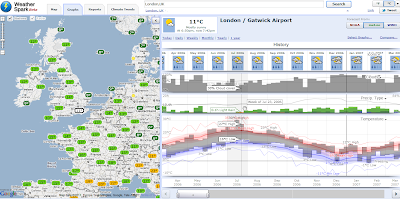
WeatherSpark Beta- Historical weather patterns visualised

An excellent Google maps mashup -an early contender for best gmap 2011.

WeatherSpark Beta


"WeatherSpark is a pretty amazing Google Map of current and historical weather conditions. The site lets you view the historical records of over 4,000 weather stations."

example above
http://weatherspark.com/#!graphs;ws=28726;t=321909;mspp=37115493


Climate Patterns
WeatherSpark Climate Beta


If you are more interested in today's weather you can just center the map on your location and view the current temperature and the current precipitation radar

http://weatherspark.com/#

source:
http://googlemapsmania.blogspot.com/2011/05/history-of-weather-on-google-maps.html

Labels: , , ,

21 February 2011

Rain Alarm Map

Rain Alarm Map

Rain Alarm Map


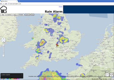
Get live alerts for incoming rain or snow.

The simple idea of this web map and app is to warn you against approaching precipitation like rain or snow. Therefore the app checks in a perimeter of 75 km / 47 miles every 30 minutes, if there is something approaching. Simply leave the page open in the background and you'll get notified.

Note that the map is refreshed automatically so you do not have to reload the page. The buttons on the bottom right en- or disable the animation and the alarm functionality.

The data used originates from governmental weather services and is available for the USA, Canada, Australia, the UK, Ireland, Norway, Germany, the Netherlands, Spain including the Balearic and the Canary Islands.

Browsers:
The alarm notifications work best with Google Chrome. For Mozilla Firefox and Microsoft Internet Explorer the alarms work as well, though they are not as pretty and intuitive.

With some browsers your location can be determined automatically or otherwise a rough estimate is used. To correct your location, simply drag the marker to be able to receive correct alarms.

Internet Explorer
You need to keep Rain Alarm as the active tab to be able to receive alarm notifications even when the Internet Explorer is minimized.

Mobile

The app is also available for Android as well as iOS.

Map:
http://www.rain-alarm.com/

Source:
http://googlemapsmania.blogspot.com/2011/02/google-map-warning-of-rain.html

Labels: , , ,

23 June 2010

Met Office Events Weather Maps

Met Office Events Weather Maps

Whether your interested in The World Cup in South Africa, Wimbledon Tennis Championships or the Music at the Glastonbury Festival the Met Office has released weather map events.

Met Office Weather Events Glastonbury Map
Check out the Glastonbury Temperature, UV, Pollen Forescast weather is continously updated to provide you with warning (Thunderstorms, high ultraviolet rays and hopefully sun.)

Met Office Weather Events Wimbledon UV Map
See UV Sun Index guidance with the interactive symbols on the Wimbledon Weather Map


"The World Cup finals will, for the first time, be taking place in Africa, with South Africa playing the host nation for what is regarded as the world's largest sporting spectacular.

The tournament is taking place between 11 June 2010 and 11 July 2010.

The Met Office are providing a weather forecast for the venues of the World Cup finals, click on the weather symbols on the map to get more detailed information on the venue of interest. "

Met Office Weather Events World Cup Map
Looks like Sunny all the way in South Africa for the World Cup 2010.

Map Links
http://www.metoffice.gov.uk/public/pws/events/worldcup/
http://www.metoffice.gov.uk/weather/uk/wimbledon.html
http://www.metoffice.gov.uk/weather/uk/glastonbury.html

Source:
http://www.metoffice.gov.uk/public/pws/events/

update: 24th June 2010
Met Office News - Press Release on these Events
http://www.metoffice.gov.uk/corporate/pressoffice/2010/pr20100624.html

Labels: , , , , , , ,

05 January 2010

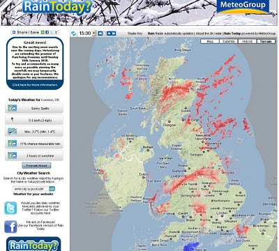
A Real Snow Map #uksnow

A Real Snow Map #uksnow

updated 17.51 06/01/2010

A Real Snow Map

via @jasonhesse

More Interactive Maps are
UK SNOW MAP
http://www.raintoday.co.uk/

The Met Office Invent site
http://www.metoffice.gov.uk/public/pws/invent/weathermap/

BBC Weather
http://news.bbc.co.uk/weather/forecast/10209


Wunderground
http://www.wunderground.com/global/UK.html

#uksnow Map 2.0
http://uksnow.benmarsh.co.uk/

UK Snow Dynamic Crowd Sourced Maps

The UK has been experiencing a snow storm recently and people have been tweeting about it!. This page has been setup, as part of my research into crowd sourcing, to track the #uksnow hashtag based on the following format [Postcode District Score/10] since #uksnow became a trending topic. You can help out by tagging the current snow conditions in your own Tweets like this:
http://www.casa.ucl.ac.uk/sjg/twitter/

more info - http://stevenjamesgray.com/projects/uksnowmaps/


Labels: , , , , , ,

16 July 2009

The Best UK Google Map API Mashup Ever?

The Best UK Google Map API Mashup Ever?

update 20th July 2009
This is now back up and running as you see it here on the blog. The Met Office reverted the code last week after this blog post
http://www.metoffice.gov.uk/invent/pwsviewer/


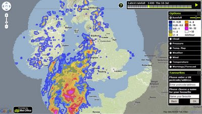
There was a sneak peak of this a few weeks ago, but the update to this is truly amazing.
This has the 'super wow' factor.

Full Credit to the Met Office on this and picking up on feedback from webs users and readers of this Mapperz Blog

Met Office - Current Weather
The Current Weather Outlook over the UK with nice clean self-explanatory icons.

Met Office - Rainfall Radar Weather
Full Radar Coverage of Current Rainfall and works smoothly in animated 'play' mode.

Met Office - Temperature Map Weather
Now with the Mapperz most requested overlay - temperature - users can use the slider on the legend to adjust the opacity (transparency) of the overlay.

Met Office - Wind and Direction Map Weather
Wind speed and directions now available - clear icons with more information on hovering over the icons.


Met Office - Weather Warnings Map title=
Weather Warnings illustrated by counties across the UK

The Met Office Weather Map- Enjoy!
http://www.metoffice.gov.uk/invent/pwsviewer/
17/07/2009
update Bad Weather stops play.
"reverted until we get over this weekend's severe weather event."
so come back next week.
Well done too all involved a great service just got better (Next week).
(special thanks to @angerelle)

Note Firefox users with FireBug might experience the no map issue - either disable firebug or use another browser to view this map, its worth it for the experience.
(this is fixed!)

Related Post
http://mapperz.blogspot.com/2009/06/met-office-google-maps-weather.html

Follow Mapperz on Twitter

Labels: , , , , , , ,

06 July 2009

US National Weather [RADAR] Animated

US National Weather Animated

"A very good visual way to mix Openlayers and Google Maps with near real-time Radar information"

US National Weather Service Animated
Animated Weather and Hazard Warning (Fire Risk, Flash Flooding etc)
Very Smooth and Animates in near real-time over the next 24hrs

Speed of animation can be controlled as is the Opacity of the overlays.

Individual Weather Monitoring Stations can also be displayed

South Dakota Flood Warning

At the time of this post South Dakota has Flood warnings across the state
http://radar.srh.noaa.gov/?zoom=3&lat=43.8511&lon=-98.4131&layers=B000TTTTTTTT

Feedback Survey - Good to see they want feedback from users

http://www.weather.gov/survey/nws-survey.php?code=RIDGEII


KMZ Overlays for Google Earth (and Other KMZ accepting applications)

"While the RIDGE radar display allows for the use of interactive toggles with the image, RIDGE images can be best utilized with GIS software. This page allows you to create "kmz" files which are compressed "kml" files compatible with several GIS software applications"

http://radar.weather.gov/ridge/kmzgenerator.php

UK Met office related post (take note UK MET OFFICE ;)
http://mapperz.blogspot.com/2009/06/met-office-google-maps-weather.html

Labels: , , , ,

30 June 2009

The Met Office (Google Maps) Weather

The Met Office (Google Maps) Weather

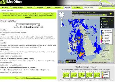
The Met office are experimenting with the Google Maps API - this is a very interesting move. The results are quite impressive and this is a potentially a bold move and a great way to represent weather forecasting on the web.
This includes animating the weather for the next 24hrs using the time bar above the map.

The Met Office Weather using Google Maps 1st July
Google Maps API with Meteorological Data overlayed to represent very visually the foretasted weather for the UK. Animation is controlled by the 'Play' Button.

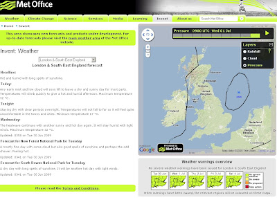
Not only is rainfall overlayed but isobars representing the pressure is also animated.

The Met Office Weather using Google Maps Isobars
Isobars (Barometric Pressure) overlay on Google Maps

There is Temperature, Winds(strength/direction) missing currently, this is planned for the future and will be very useful for users.

This is an impressive experiment and greatly improves the very static generated images that currently dominated the Met Office Website.

Well done to all involved, this is what the public want.

The Met Office Google Map (Experimental)

Currently the BBC have Temperature and Winds [Flash required]
http://news.bbc.co.uk/weather/forecast/10209

Suggestions - Opacity Control - current radar blocks the background map.
Temperature and Winds layers would be very handy.
5 day forecast possible?
An a final request on the raw data - it possible to have a basic GeoRSS feed for budding developers to create weather overlays for their own maps
GeoRSS weather warnings?

Labels: , , , , , ,

10 February 2009

Nokia Maps v3.0 updated (including ovi maps)
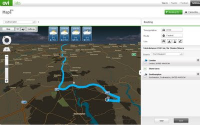
Nokia Maps v3.0 updated (including ovi maps)

Nokia Maps v3.0 Updated
Nokia Ovi Maps (web browser) now can save routes and sync with your nokia maps v3 - mobile/cell device (sign in required to save routes) - Map in nighttime mode with weather and route.
  • You can rotate the map and view 3D landmarks from all directions.
  • In 3D view mode, you can tilt the view by pressing 2 and 8 button
  • 2D/3D mode works with all map modes, now with Satellite and Terrain
  • My Places has option "Point me to" for any saved place/landmark saves the viewing angle as well.
  • Synchronisation of Favourites and Collections with Ovi Maps and vice versa (use in online mode, enable Internet connection), you can now plan routings on Ovi Maps and synchronise to your device
Compatibility and system requirements
Maps Updater and Map Loader 3.0 require Microsoft Windows XP or Vista.
Maps Updater requires Nokia PC Suite to be installed on your computer.

Maps 3.0 Beta works with Nokia devices based on:
S60 3rd Edition Feature Pack 1 (E71, E66, 6110 Navigator, N95, N95 8GB, N82)
S60 3rd Edition Feature Pack 2 (N96, N85, N79, 6650, 6210 Navigator, 6220 Classic, N78)

Ovi MapsBeta works on IE6 (Windows XP), IE7, Firefox 2 and Firefox 3 (Windows XP or Vista).

Note: you cannot use the Nokia Maps 2 and Nokia Maps 3 on the same device. If you have a license for sat-nav (directions/traffic updates etc) you might lose your full licence.
Backup your device before trying beta software.

"Your travel guide licences are not valid in the beta version of Maps 3.0. However, the guide licences will be valid again in the final version of Maps 3.0."

Future implementations (commercial release)
  • Safety spot warner's in selected countries
  • Extended country coverage for Traffic info service
  • Weather information
  • Premium POI content for travel, selected events and cinema
http://betalabs.nokia.com/betas/view/nokia-maps-30-ovi-maps

source and many more screenshots:
http://www.allaboutsymbian.com/news/item/8921_Nokia_Maps_30_beta_updated.php

Labels: , , , , ,

04 February 2009

SpinCloud - Weather Mashup Map

SpinCloud - Weather Mashup Map

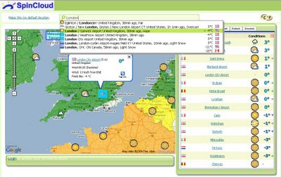
Spin Cloud - Weather Map
Nice integration of weather feeds and mapping from Google Maps. Easy to use.

"Weather mashup with tagging, forecasting, and commenting, plus personalization and weather tracking. RSS enabled. Registration via OpenId or Facebook Connect."

Find the Hottest, Coldest, Windiest, Rainiest, Snowiest or just a Snapshot of your local weather.

http://spincloud.com/

Labels: , , , , , , ,

25 October 2008

New BBC Weather Maps (Beta v1.0)

New BBC Weather Maps (Beta v1.0)

New BBC Weather Beta Maps
The BBC are looking into revamping thier current weather service for 2009.
The are currently looking into adding more interactive features the visual weather portal.


New Features: *subject to feedback and beta status.
A 'one-stop shop' (no need to wait for another page to load)
Better Navigation to Maps in the users 'area of interest'
Flash based maps - animation is smoother and faster [tested with Flash Player 10]
More updates from the Met Office = Better accuaracy and currency of weather.
More localised weather particularly in the United Kingdom.

New BBC Weather Beta - North America Pressure Maps
Maps are now embedded in Flash - faster loading and smoother animations.

BBC Weather is now location based vs the old version by type of forecast.

"all forecast information is now organised by location rather than by type of forecast it might look like there is less information on the site."

More to be added in later beta versions
"The map presenter will also be more interactive and you will be able to view maps for surrounding areas without leaving the page. Later in 2008 we will be adding embedded video forecasts."

"We are currently sourcing forecast temperatures for coastal waters and will add these to the site when they are ready."

Try the BBC Beta Weather Maps
Click to See BBC Weather Beta Maps
(click the image to view)

Please review the site and request new features like - georss, archive weather maps by date, 3D option, transparent overlays (cloud+radar etc) are just a few as examples.
maybe rainfall charts, wind factor, chill factor...

More information
http://www.bbc.co.uk/weather/bbcweather/features/website_redesign.shtml

Mapperz

Labels: , , , , , ,

28 August 2008

BBC Extreme Weather (in Windsor)

BBC Extreme Weather (in Windsor)

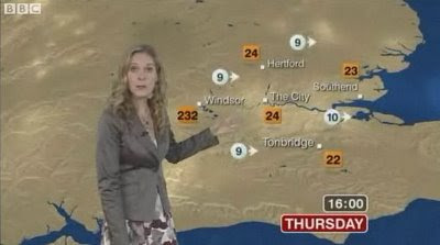
Extreme BBC Weather Windsor
232 degrees in Windsor's was a slight error on the BBC Weather Map this morning...

Blame the Gremlins

Screenshot and news source:
http://news.bbc.co.uk/1/hi/uk/7585641.stm
(non-UK users may not be able to see the video)

Labels: , , , ,

23 July 2008

WunderMap - Hurricane Dolly Live Tracking

WunderMap - Hurricane Dolly Live Tracking
Hurricane Dolly Radar by WunderMap
WunderMap Animates the Current Radar (Rainfall)

This is one of the best way to see a hurricane with Google Maps.
Vast amounts of data collected and represented in a fashion that the user can have as much or as little information displayed.

Below are a few options:
Webcams

Well done to the WunderMap Team,
http://www.wunderground.com/

Hurricane Dolly's current status

Labels: , , , , ,

23 January 2008

The Weather Cam Map (UK)

The Weather Cam Map (UK)

Weather Cam MapWeather Cam Map Accuracy
Webcams show you the weather live - Coloured Polygons show you an accuracy ratio

  • Nice clean map
  • Easy to use and update
  • Informative and up-to-date
Note:
This is not intended to show how weather forecasting can be inaccurate, but more to show which areas are served well by a general weather forecast.

Map created by beats! design

Suggestions?
Maybe a georss overlay from the Met Office?
(as google maps api supports georss)

Example is BlueGhost UK Weather

Labels: , , , , ,

19 March 2007

Europe Weather Alert Map

Wind
Extreme high temperature
Rain
Extreme low temperature
Snow/Ice
Coastal Event
Thunderstorms
Forest Fire
Fog
Avalanches

MeteoAlarm (Weather) Map
all mapped here, okay not the most dynamic mapping (static images updated on alert) but to make it available in 12 languages is very help to traveling Europeans, though no Welsh or Gaelic.

mapperz

Labels: , , , , ,

15 January 2007

Retro Map - BBC Ceefax Map Live

Retro Map - BBC Ceefax Map Live
Ceefax Weather Map Page 401 BBC Ceefax

See old style Ceefax (from analogue signal) live on the internet.
(click the 400 at the bottom then 401 for the Weather Map)

Also available for mobile devices

Ceefax (wiki)

Ceefax TV
© Ceefax is a registered trademark of the BBC Corporation
© Aertel is a registered trademark of RTE

Labels: , , , ,

Gchart - Currency, Local Time and Weather Map

Gchart Currency Map
Gchart - Currency, Local Time and Weather Map all available on from one source and one map.
Simple and a easy to use.

Also mapped is video and web blogs

Mapperz (now with rss email feed - visit blog to subscribe)

Labels: , , , , , ,

23 December 2006

US Weather Map Updated

Weather Map
Nice weather overlay

Labels: , , ,

20 November 2006

Global Climate Map and Charts

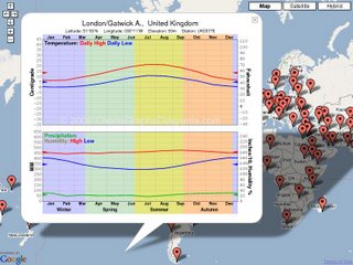
Average weather charts for 4305 global locations. Most show precipitation, many show high and low temperatures, some also have humidity.

Interactive Climate Map

When you zoom in, some more locations will show up in a few seconds.

This site is for Tourists, other travelers, students, meteorologists, climatologists, or anyone else interested in climate around the world.

Labels: , , , , , , ,